Nottely Lake Fishing Report
Synthesis generated comprehensive plan with professional recommendations.
Nottely Lake Fishing Report
Generated Apr 4, 2026, 1:50 AM.
Key fishing read
- Max thump: giant spinnerbaits, slow roll, contact cover
- Fall: chase baitfish in creeks; spinnerbaits/lipless cranks to cover water
- Based on the provided imagery for Nottely Lake, here is the professional water clarity and tactical fishing analysis.
1. Overall Water Quality Summary
The imagery indicates a highly uniform water quality profile across the main body of Nottely Lake. The lake is currently dominated by low-sediment, low-chlorophyll conditions (represented by the dark/black base in the provided visuals). This indicates a stable, clear-water environment with high visibility, likely in the 8–15+ foot range. There is a notable absence of significant sediment plumes or major algae blooms, suggesting the lake is currently in a "finesse-dominant" state.
2. Detailed Clarity Zone Mapping & Characterization
- Primary Zone (The Main Basin & Major Arms):
- Matrix Position: Bottom-Left (Dark/Black).
- Combined Conditions: Low sediment + Low chlorophyll.
- Visibility: 8–15+ feet.
- Tactical Implications: This is a high-visibility environment. Fish will be highly sensitive to boat pressure and unnatural lure profiles. Stealth is the priority.
- Secondary Zone (Isolated Western Shoreline/Inflow points):
- Matrix Position: Top-Left (Red/Tan highlights).
- Combined Conditions: High sediment (TSS) + Low chlorophyll.
- Visibility: 2–6 feet.
- Tactical Implications: These localized areas represent the only "stained" water on the lake. These are high-percentage ambush points where fish will be less spooked by boat presence and more willing to strike reaction baits.
3. Turbidity/Algae Sources & Transition Zones
- Sources: The red/tan highlights on the western shoreline suggest localized runoff or bank erosion, likely from recent localized rain or wind-driven wave action against exposed banks.
- Transition Zones: The "edges" where the black (clear) water meets the tan/red (stained) water are the most critical areas. These transition lines act as natural feeding corridors. Predators (Bass/Walleye) will often sit just inside the clear water, looking into the stained water to ambush baitfish that are disoriented by the change in visibility.
4. Species-Specific Clarity Strategy
- Bass (Largemouth/Spotted): Focus on the transition zones along the western shoreline. Use the stained water to hide your approach, then cast into the clear water or along the "mudline" edge.
- Walleye: Target the deeper, clear-water sections of the main basin. Given the 65°F water temperature, they will likely be suspended or holding near structure in the clear, low-chlorophyll zones.
- Crappie: Look for them in the slightly stained western coves. The reduced visibility (2–6 ft) provides them with security, allowing them to hold tighter to cover than they would in the main basin.
5. Tactical Fishing Adjustments
- Clear Zone (Main Basin):
- Lures: Natural shad-pattern jerkbaits, drop-shot rigs with 6lb–8lb fluorocarbon, and small finesse swimbaits.
- Presentation: Long casts are mandatory. Minimize trolling motor use; drift or use Spot-Lock to maintain position.
- Stained Zone (Western Shoreline/Inflows):
- Lures: 3/8 oz spinnerbaits with gold blades, square-bill crankbaits in crawfish patterns, or jigs with rattles.
- Presentation: More aggressive, faster retrieves. The noise and vibration are key to helping fish locate the lure in the 2–6 ft visibility range.
- Clarity Breaks: Use a "search bait" (like a vibrating jig) to work the edge of the transition. If you get a strike, slow down with a soft plastic to pick apart the immediate area.
6. Seasonal Context
The current visual pattern—characterized by widespread clarity and minimal chlorophyll—suggests a stable, post-turnover or pre-bloom state. The lack of widespread red/orange (high chlorophyll) indicates that the lake is not currently experiencing a major summer algae bloom. The localized tan/red sediment markers suggest that any turbidity is driven by mechanical factors (wind/runoff) rather than biological productivity. This is an excellent time for finesse tactics and sight-based fishing strategies.
- Day 1: High pressure (1024mb) - tougher bite, use finesse tactics
- Day 1: High winds (17mph) - seek protected areas, use heavier lures
- Day 1: MostlyCloudy, High: 76°F, Low: 59°F
- Day 2: High pressure (1021mb) - tougher bite, use finesse tactics
- Day 2: High winds (22mph) - seek protected areas, use heavier lures
Tool analysis details
Lure Matrix Wind Clarity
Lure guidance for wind=windy, clarity=unknown, phase=fall.
Findings:
- Max thump: giant spinnerbaits, slow roll, contact cover
- Fall: chase baitfish in creeks; spinnerbaits/lipless cranks to cover water
Analyze Water Clarity
Based on the provided imagery for Nottely Lake, here is the professional water clarity and tactical fishing analysis.
1. Overall Water Quality Summary
The imagery indicates a highly uniform water quality profile across the main body of Nottely Lake. The lake is currently dominated by low-sediment, low-chlorophyll conditions (represented by the dark/black base in the provided visuals). This indicates a stable, clear-water environment with high visibility, likely in the 8–15+ foot range. There is a notable absence of significant sediment plumes or major algae blooms, suggesting the lake is currently in a "finesse-dominant" state.
2. Detailed Clarity Zone Mapping & Characterization
- Primary Zone (The Main Basin & Major Arms):
- Matrix Position: Bottom-Left (Dark/Black).
- Combined Conditions: Low sediment + Low chlorophyll.
- Visibility: 8–15+ feet.
- Tactical Implications: This is a high-visibility environment. Fish will be highly sensitive to boat pressure and unnatural lure profiles. Stealth is the priority.
- Secondary Zone (Isolated Western Shoreline/Inflow points):
- Matrix Position: Top-Left (Red/Tan highlights).
- Combined Conditions: High sediment (TSS) + Low chlorophyll.
- Visibility: 2–6 feet.
- Tactical Implications: These localized areas represent the only "stained" water on the lake. These are high-percentage ambush points where fish will be less spooked by boat presence and more willing to strike reaction baits.
3. Turbidity/Algae Sources & Transition Zones
- Sources: The red/tan highlights on the western shoreline suggest localized runoff or bank erosion, likely from recent localized rain or wind-driven wave action against exposed banks.
- Transition Zones: The "edges" where the black (clear) water meets the tan/red (stained) water are the most critical areas. These transition lines act as natural feeding corridors. Predators (Bass/Walleye) will often sit just inside the clear water, looking into the stained water to ambush baitfish that are disoriented by the change in visibility.
4. Species-Specific Clarity Strategy
- Bass (Largemouth/Spotted): Focus on the transition zones along the western shoreline. Use the stained water to hide your approach, then cast into the clear water or along the "mudline" edge.
- Walleye: Target the deeper, clear-water sections of the main basin. Given the 65°F water temperature, they will likely be suspended or holding near structure in the clear, low-chlorophyll zones.
- Crappie: Look for them in the slightly stained western coves. The reduced visibility (2–6 ft) provides them with security, allowing them to hold tighter to cover than they would in the main basin.
5. Tactical Fishing Adjustments
- Clear Zone (Main Basin):
- Lures: Natural shad-pattern jerkbaits, drop-shot rigs with 6lb–8lb fluorocarbon, and small finesse swimbaits.
- Presentation: Long casts are mandatory. Minimize trolling motor use; drift or use Spot-Lock to maintain position.
- Stained Zone (Western Shoreline/Inflows):
- Lures: 3/8 oz spinnerbaits with gold blades, square-bill crankbaits in crawfish patterns, or jigs with rattles.
- Presentation: More aggressive, faster retrieves. The noise and vibration are key to helping fish locate the lure in the 2–6 ft visibility range.
- Clarity Breaks: Use a "search bait" (like a vibrating jig) to work the edge of the transition. If you get a strike, slow down with a soft plastic to pick apart the immediate area.
6. Seasonal Context
The current visual pattern—characterized by widespread clarity and minimal chlorophyll—suggests a stable, post-turnover or pre-bloom state. The lack of widespread red/orange (high chlorophyll) indicates that the lake is not currently experiencing a major summer algae bloom. The localized tan/red sediment markers suggest that any turbidity is driven by mechanical factors (wind/runoff) rather than biological productivity. This is an excellent time for finesse tactics and sight-based fishing strategies.
Findings:
- Based on the provided imagery for Nottely Lake, here is the professional water clarity and tactical fishing analysis.
1. Overall Water Quality Summary
The imagery indicates a highly uniform water quality profile across the main body of Nottely Lake. The lake is currently dominated by low-sediment, low-chlorophyll conditions (represented by the dark/black base in the provided visuals). This indicates a stable, clear-water environment with high visibility, likely in the 8–15+ foot range. There is a notable absence of significant sediment plumes or major algae blooms, suggesting the lake is currently in a "finesse-dominant" state.
2. Detailed Clarity Zone Mapping & Characterization
- Primary Zone (The Main Basin & Major Arms):
- Matrix Position: Bottom-Left (Dark/Black).
- Combined Conditions: Low sediment + Low chlorophyll.
- Visibility: 8–15+ feet.
- Tactical Implications: This is a high-visibility environment. Fish will be highly sensitive to boat pressure and unnatural lure profiles. Stealth is the priority.
- Secondary Zone (Isolated Western Shoreline/Inflow points):
- Matrix Position: Top-Left (Red/Tan highlights).
- Combined Conditions: High sediment (TSS) + Low chlorophyll.
- Visibility: 2–6 feet.
- Tactical Implications: These localized areas represent the only "stained" water on the lake. These are high-percentage ambush points where fish will be less spooked by boat presence and more willing to strike reaction baits.
3. Turbidity/Algae Sources & Transition Zones
- Sources: The red/tan highlights on the western shoreline suggest localized runoff or bank erosion, likely from recent localized rain or wind-driven wave action against exposed banks.
- Transition Zones: The "edges" where the black (clear) water meets the tan/red (stained) water are the most critical areas. These transition lines act as natural feeding corridors. Predators (Bass/Walleye) will often sit just inside the clear water, looking into the stained water to ambush baitfish that are disoriented by the change in visibility.
4. Species-Specific Clarity Strategy
- Bass (Largemouth/Spotted): Focus on the transition zones along the western shoreline. Use the stained water to hide your approach, then cast into the clear water or along the "mudline" edge.
- Walleye: Target the deeper, clear-water sections of the main basin. Given the 65°F water temperature, they will likely be suspended or holding near structure in the clear, low-chlorophyll zones.
- Crappie: Look for them in the slightly stained western coves. The reduced visibility (2–6 ft) provides them with security, allowing them to hold tighter to cover than they would in the main basin.
5. Tactical Fishing Adjustments
- Clear Zone (Main Basin):
- Lures: Natural shad-pattern jerkbaits, drop-shot rigs with 6lb–8lb fluorocarbon, and small finesse swimbaits.
- Presentation: Long casts are mandatory. Minimize trolling motor use; drift or use Spot-Lock to maintain position.
- Stained Zone (Western Shoreline/Inflows):
- Lures: 3/8 oz spinnerbaits with gold blades, square-bill crankbaits in crawfish patterns, or jigs with rattles.
- Presentation: More aggressive, faster retrieves. The noise and vibration are key to helping fish locate the lure in the 2–6 ft visibility range.
- Clarity Breaks: Use a "search bait" (like a vibrating jig) to work the edge of the transition. If you get a strike, slow down with a soft plastic to pick apart the immediate area.
6. Seasonal Context
The current visual pattern—characterized by widespread clarity and minimal chlorophyll—suggests a stable, post-turnover or pre-bloom state. The lack of widespread red/orange (high chlorophyll) indicates that the lake is not currently experiencing a major summer algae bloom. The localized tan/red sediment markers suggest that any turbidity is driven by mechanical factors (wind/runoff) rather than biological productivity. This is an excellent time for finesse tactics and sight-based fishing strategies.
Analyze Weather Conditions
Weather analysis for Nottely Lake completed
Findings:
- Day 1: High pressure (1024mb) - tougher bite, use finesse tactics
- Day 1: High winds (17mph) - seek protected areas, use heavier lures
- Day 1: MostlyCloudy, High: 76°F, Low: 59°F
- Day 2: High pressure (1021mb) - tougher bite, use finesse tactics
- Day 2: High winds (22mph) - seek protected areas, use heavier lures
Analyze Thermal Patterns
1. Overall Thermal Landscape Summary
- Assumed Orientation: North is at the top of the image.
- Major Visual Anchors: The lake is characterized by a complex, dendritic (branching) main body in the NW quadrant, a central basin, and a smaller, isolated pool in the SE corner.
- Thermal Summary: The lake is in a cold-water state. The surface temperatures are dominated by the Medium Blue (46-52°F / 8-11°C) range, with pockets of Dark Blue (42-46°F / 6-8°C) appearing in the most constricted, narrow arms of the northern and western sections.
- Temperature Range: Based on the provided scale and image labels, the visible surface temperatures range from approximately 45°F to 51°F.
2. Detailed Thermal Feature Analysis
Temperature Breaks
- Location: The most significant thermal break occurs in the central basin, where the water transitions from the Medium Blue (46-52°F) of the main body to a more intense, darker blue (42-46°F) pocket in the southern portion of that central section.
- Significance: This transition represents a shift from early spring transition water to late winter conditions. Fish will likely be holding on the warmer side of this break, utilizing the slightly higher metabolic potential of the 50-51°F water.
Pockets/Patches
- Location: A distinct, warmer patch (labeled 51°F) is visible in the southern end of the central basin.
- Significance: This is the warmest surface water in the main body. In these cold conditions, this area acts as a thermal refuge where fish are most likely to be active.
Gradients
- Location: A gradual warming gradient is visible moving from the narrow, northernmost fingers (45°F) toward the central basin (51°F).
- Significance: Fish will likely be migrating along these gradients, moving toward the warmer central basin as the sun warms the surface.
Uniform Areas
- Location: The northern and western dendritic arms exhibit a relatively uniform Medium Blue (46-47°F) signature.
- Significance: These areas are currently stable and cold. Expect fish to be lethargic and tightly associated with any available cover or structure, as there is no thermal incentive to move.
3. Insightful Fish Behavior Interpretation
- General Behavior: With surface temperatures ranging from 45°F to 51°F, the fish are in a "cold-water" mode. Metabolism is low, and feeding windows will be short.
- Movement: Fish will be seeking the warmest available surface water (the 50-51°F zones). They are likely to be found in the central basin rather than the colder, narrow northern fingers.
- Surface Activity: Expect minimal surface feeding. Fish will be holding near the bottom or tight to structure, moving only short distances to intercept prey.
4. Satellite Correlation Analysis
- Inflow/Outflow: The narrow, colder fingers (45°F) in the NW quadrant likely represent inflow points where colder runoff is entering the lake. These areas are currently the least productive due to the lower temperatures.
- Wind-Mixing: The central basin, being the widest part of the lake, shows the most consistent warming (50-51°F), likely due to increased surface area exposure to solar radiation and less influence from cold, narrow-channel inflows.
5. Actionable Fishing Recommendations
- Target the Warmest Water: Focus your efforts in the central basin where the 50-51°F water is located. This is the most "active" water on the lake.
- Slow Down: Given the 45-51°F range, use slow-moving, finesse-style presentations. The fish are not in an aggressive, chasing mood.
- Avoid the Extremes: The narrow, northernmost fingers (45-47°F) are currently too cold for consistent activity. Spend your time in the wider, central sections where the thermal signature is warmer.
- Target the Break: Position your boat to cast from the 51°F water toward the edge of the 47°F water in the central basin. This thermal transition zone is the highest-percentage area for finding fish that are beginning to move toward warmer water.
Findings:
- Current surface temperature: 65.0°F. Prime fishing conditions with high fish activity expected. Target areas with consistent temperatures in this range and edges where temperature transitions occur.
-
1. Overall Thermal Landscape Summary
- Assumed Orientation: North is at the top of the image.
- Major Visual Anchors: The lake is characterized by a complex, dendritic (branching) main body in the NW quadrant, a central basin, and a smaller, isolated pool in the SE corner.
- Thermal Summary: The lake is in a cold-water state. The surface temperatures are dominated by the Medium Blue (46-52°F / 8-11°C) range, with pockets of Dark Blue (42-46°F / 6-8°C) appearing in the most constricted, narrow arms of the northern and western sections.
- Temperature Range: Based on the provided scale and image labels, the visible surface temperatures range from approximately 45°F to 51°F.
2. Detailed Thermal Feature Analysis
Temperature Breaks
- Location: The most significant thermal break occurs in the central basin, where the water transitions from the Medium Blue (46-52°F) of the main body to a more intense, darker blue (42-46°F) pocket in the southern portion of that central section.
- Significance: This transition represents a shift from early spring transition water to late winter conditions. Fish will likely be holding on the warmer side of this break, utilizing the slightly higher metabolic potential of the 50-51°F water.
Pockets/Patches
- Location: A distinct, warmer patch (labeled 51°F) is visible in the southern end of the central basin.
- Significance: This is the warmest surface water in the main body. In these cold conditions, this area acts as a thermal refuge where fish are most likely to be active.
Gradients
- Location: A gradual warming gradient is visible moving from the narrow, northernmost fingers (45°F) toward the central basin (51°F).
- Significance: Fish will likely be migrating along these gradients, moving toward the warmer central basin as the sun warms the surface.
Uniform Areas
- Location: The northern and western dendritic arms exhibit a relatively uniform Medium Blue (46-47°F) signature.
- Significance: These areas are currently stable and cold. Expect fish to be lethargic and tightly associated with any available cover or structure, as there is no thermal incentive to move.
3. Insightful Fish Behavior Interpretation
- General Behavior: With surface temperatures ranging from 45°F to 51°F, the fish are in a "cold-water" mode. Metabolism is low, and feeding windows will be short.
- Movement: Fish will be seeking the warmest available surface water (the 50-51°F zones). They are likely to be found in the central basin rather than the colder, narrow northern fingers.
- Surface Activity: Expect minimal surface feeding. Fish will be holding near the bottom or tight to structure, moving only short distances to intercept prey.
4. Satellite Correlation Analysis
- Inflow/Outflow: The narrow, colder fingers (45°F) in the NW quadrant likely represent inflow points where colder runoff is entering the lake. These areas are currently the least productive due to the lower temperatures.
- Wind-Mixing: The central basin, being the widest part of the lake, shows the most consistent warming (50-51°F), likely due to increased surface area exposure to solar radiation and less influence from cold, narrow-channel inflows.
5. Actionable Fishing Recommendations
- Target the Warmest Water: Focus your efforts in the central basin where the 50-51°F water is located. This is the most "active" water on the lake.
- Slow Down: Given the 45-51°F range, use slow-moving, finesse-style presentations. The fish are not in an aggressive, chasing mood.
- Avoid the Extremes: The narrow, northernmost fingers (45-47°F) are currently too cold for consistent activity. Spend your time in the wider, central sections where the thermal signature is warmer.
- Target the Break: Position your boat to cast from the 51°F water toward the edge of the 47°F water in the central basin. This thermal transition zone is the highest-percentage area for finding fish that are beginning to move toward warmer water.
- Spring warming: Focus on shallow bays and areas showing the warmest surface temperatures in thermal imagery as fish move into spawning areas.
Analyze Solunar Timing
Solunar timing analysis for Nottely Lake completed
Findings:
- 2026-04-03 Major feeding periods: 01:54 AM - 04:24 AM, 03:05 PM - 05:35 PM
- 2026-04-03 Minor feeding periods: 09:22 PM - 10:52 PM, 07:19 AM - 08:49 AM
- 2026-04-04 Major feeding periods: 02:38 AM - 05:08 AM, 03:50 PM - 06:20 PM
- 2026-04-04 Minor feeding periods: 10:23 PM - 11:53 PM, 07:49 AM - 09:19 AM
- 2026-04-05 Major feeding periods: 03:25 AM - 05:55 AM, 04:38 PM - 07:08 PM
Analyze Satellite Imagery
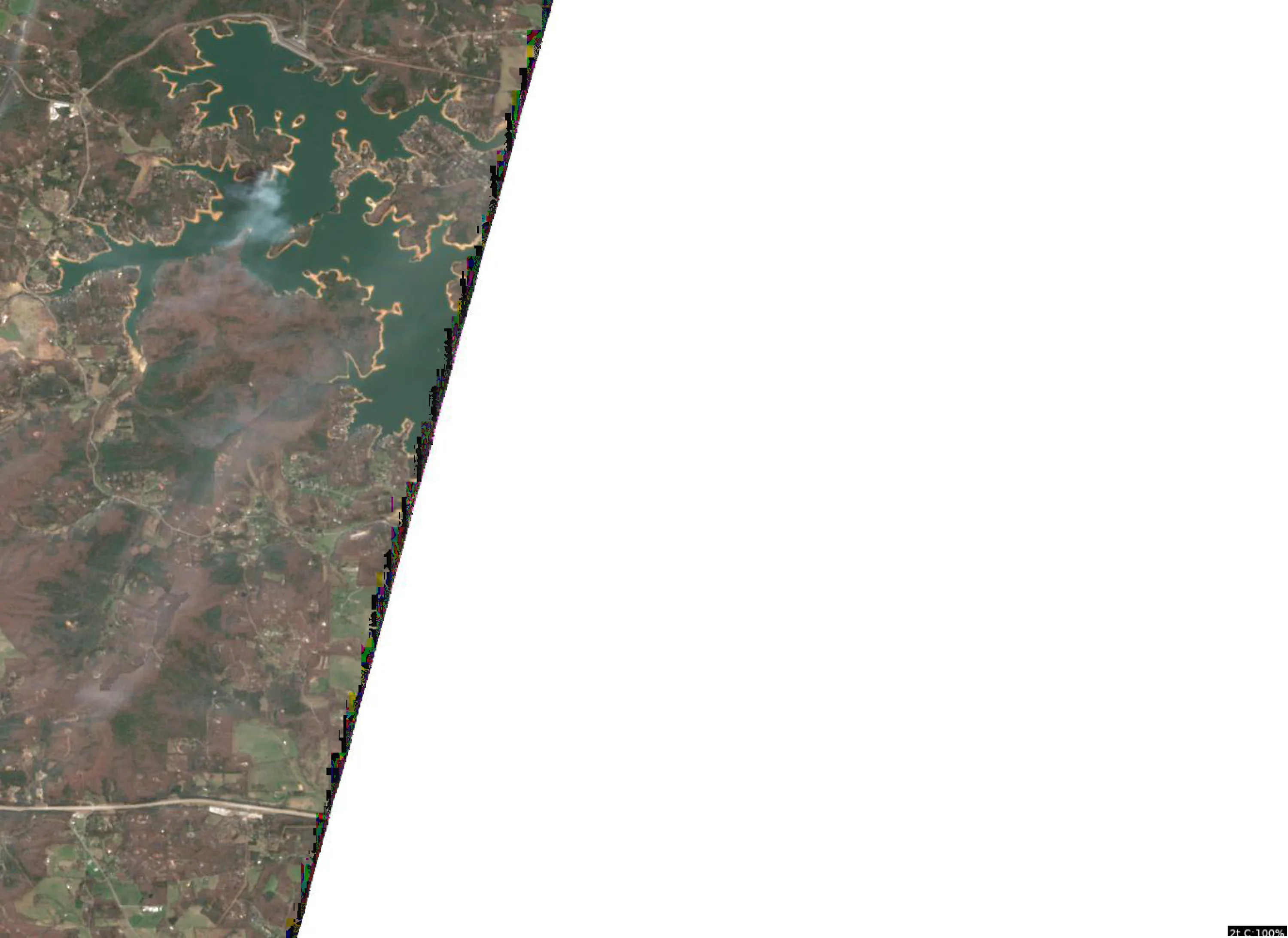
This analysis focuses on the northern portion of Nottely Lake, characterized by complex, winding shorelines, multiple coves, and significant point-to-cove transitions.
1. LAKE OVERVIEW
The visible portion of Nottely Lake is a highly irregular, dendritic reservoir. It is defined by a main channel that snakes through the center, flanked by numerous deep-reaching coves and secondary points. The shoreline is heavily forested, creating a high-contrast environment where points extend into the main channel, providing natural ambush spots for bass.
2. FINDABLE FISHING SPOTS
Spot 1: The Northernmost "Finger" Cove
- General Area: Extreme northern tip of the visible lake.
- How to Find It: Navigate to the northernmost reach of the main channel; look for the narrow, protected cove that branches off to the west.
- What You See: A narrow, protected pocket with a distinct "V" shape at the back.
- Why Fish It: In April, this is a prime spawning area. It is protected from main-lake wind and offers shallow, warming water.
- Best Approach: Work the shoreline with soft plastics or jigs, focusing on the transition from the bank to the slightly darker water in the center.
Spot 2: The Large Western Point
- General Area: Mid-northern section, western shoreline.
- How to Find It: Look for the prominent, wide point that juts out into the main channel on the western side.
- What You See: A broad, rounded point with visible shoreline irregularities.
- Why Fish It: This point acts as a highway for fish moving from the main channel into the adjacent coves.
- Best Approach: Use a crankbait or spinnerbait to cover water along the point, moving from the shallow tip toward the deeper sides.
Spot 3: The Eastern "Double-Cove" Mouth
- General Area: Eastern shoreline, mid-section.
- How to Find It: Locate the two adjacent coves on the eastern bank; target the point that separates them.
- What You See: A sharp, narrow point separating two distinct, deep-reaching coves.
- Why Fish It: The point provides a clear "pinch point" where fish will stage before moving into the coves to feed or spawn.
- Best Approach: Focus on the tip of the point with a Carolina rig or shaky head, then work the edges of the coves.
Spot 4: The Main Channel Narrows
- General Area: Central section of the visible map.
- How to Find It: Where the main channel constricts between a large western point and an eastern shoreline protrusion.
- What You See: A visible narrowing of the main body of water.
- Why Fish It: Current and baitfish movement are often funneled through these narrows, attracting predatory species like spotted bass and walleye.
- Best Approach: Use a jerkbait or topwater lure to mimic baitfish moving through the constriction.
Spot 5: The Southern "Creek-Arm" Entrance
- General Area: Southernmost visible section.
- How to Find It: Follow the main channel south until it widens into a larger, more open basin.
- What You See: A wide, sweeping bend in the channel with a large, shallow flat on the inside.
- Why Fish It: The flat provides excellent feeding grounds for bluegill and bass, especially during the post-spawn transition.
- Best Approach: Target the edge of the flat where the water color shifts from light to dark, indicating the drop-off into the channel.
3. VISIBLE FEATURES BY SECTION
- Northern Section: Characterized by narrow, protected coves and tight shoreline turns. Ideal for early-season, shallow-water tactics.
- Central Section: Defined by the main channel and prominent, sweeping points. This is the "transition zone" where fish move between deep water and shallow spawning flats.
- Southern Section: Features wider basins and larger flats. Focus on the channel swings and the edges of the flats where the bottom composition likely changes.
4. PRACTICAL FISHING GUIDANCE
- Start: Begin in the Northern Section coves early in the morning. The water here warms fastest, and fish will be most active in the shallows.
- Mid-Morning: Move to the Central Section points. As the sun rises, fish will pull off the extreme shallows and stage on the first available structure (the points) outside the coves.
- Pattern: Follow the "Point-to-Cove" rule. If you aren't getting bites in the back of the coves, move to the points at the mouth of those same coves.
- Navigation: The lake is narrow; stay in the center of the channel when moving between sections to avoid shallow, submerged points that extend further than they appear.
Findings:
- This analysis focuses on the northern portion of Nottely Lake, characterized by complex, winding shorelines, multiple coves, and significant point-to-cove transitions.
1. LAKE OVERVIEW
The visible portion of Nottely Lake is a highly irregular, dendritic reservoir. It is defined by a main channel that snakes through the center, flanked by numerous deep-reaching coves and secondary points. The shoreline is heavily forested, creating a high-contrast environment where points extend into the main channel, providing natural ambush spots for bass.
2. FINDABLE FISHING SPOTS
Spot 1: The Northernmost "Finger" Cove
- General Area: Extreme northern tip of the visible lake.
- How to Find It: Navigate to the northernmost reach of the main channel; look for the narrow, protected cove that branches off to the west.
- What You See: A narrow, protected pocket with a distinct "V" shape at the back.
- Why Fish It: In April, this is a prime spawning area. It is protected from main-lake wind and offers shallow, warming water.
- Best Approach: Work the shoreline with soft plastics or jigs, focusing on the transition from the bank to the slightly darker water in the center.
Spot 2: The Large Western Point
- General Area: Mid-northern section, western shoreline.
- How to Find It: Look for the prominent, wide point that juts out into the main channel on the western side.
- What You See: A broad, rounded point with visible shoreline irregularities.
- Why Fish It: This point acts as a highway for fish moving from the main channel into the adjacent coves.
- Best Approach: Use a crankbait or spinnerbait to cover water along the point, moving from the shallow tip toward the deeper sides.
Spot 3: The Eastern "Double-Cove" Mouth
- General Area: Eastern shoreline, mid-section.
- How to Find It: Locate the two adjacent coves on the eastern bank; target the point that separates them.
- What You See: A sharp, narrow point separating two distinct, deep-reaching coves.
- Why Fish It: The point provides a clear "pinch point" where fish will stage before moving into the coves to feed or spawn.
- Best Approach: Focus on the tip of the point with a Carolina rig or shaky head, then work the edges of the coves.
Spot 4: The Main Channel Narrows
- General Area: Central section of the visible map.
- How to Find It: Where the main channel constricts between a large western point and an eastern shoreline protrusion.
- What You See: A visible narrowing of the main body of water.
- Why Fish It: Current and baitfish movement are often funneled through these narrows, attracting predatory species like spotted bass and walleye.
- Best Approach: Use a jerkbait or topwater lure to mimic baitfish moving through the constriction.
Spot 5: The Southern "Creek-Arm" Entrance
- General Area: Southernmost visible section.
- How to Find It: Follow the main channel south until it widens into a larger, more open basin.
- What You See: A wide, sweeping bend in the channel with a large, shallow flat on the inside.
- Why Fish It: The flat provides excellent feeding grounds for bluegill and bass, especially during the post-spawn transition.
- Best Approach: Target the edge of the flat where the water color shifts from light to dark, indicating the drop-off into the channel.
3. VISIBLE FEATURES BY SECTION
- Northern Section: Characterized by narrow, protected coves and tight shoreline turns. Ideal for early-season, shallow-water tactics.
- Central Section: Defined by the main channel and prominent, sweeping points. This is the "transition zone" where fish move between deep water and shallow spawning flats.
- Southern Section: Features wider basins and larger flats. Focus on the channel swings and the edges of the flats where the bottom composition likely changes.
4. PRACTICAL FISHING GUIDANCE
- Start: Begin in the Northern Section coves early in the morning. The water here warms fastest, and fish will be most active in the shallows.
- Mid-Morning: Move to the Central Section points. As the sun rises, fish will pull off the extreme shallows and stage on the first available structure (the points) outside the coves.
- Pattern: Follow the "Point-to-Cove" rule. If you aren't getting bites in the back of the coves, move to the points at the mouth of those same coves.
- Navigation: The lake is narrow; stay in the center of the channel when moving between sections to avoid shallow, submerged points that extend further than they appear.
Analyze Species Behavior
Species behavior analysis for Nottely Lake completed
Findings:
- Largemouth bass: Active in optimal temps (65.0°F), aggressive feeding on structure and cover
- Largemouth bass: Spring pre-spawn/spawn mode - target shallow flats and protected coves
- Spotted bass: Active in optimal temps (65.0°F), aggressive feeding on structure and cover
- Spotted bass: Spring pre-spawn/spawn mode - target shallow flats and protected coves
- White bass: Active in optimal temps (65.0°F), aggressive feeding on structure and cover
How this was synthesized
Professional fishing guide analysis integrating 7 tools: lure_matrix_wind_clarity, analyze_water_clarity, analyze_weather_conditions, analyze_thermal_patterns, analyze_solunar_timing, analyze_satellite_imagery, analyze_species_behavior. User request: 'Generate a comprehensive fishing report for Nottely Lake. Use tools to analyze satellite structure, thermal patterns, water clarity, weather, and solunar timing, then synthesize a concise plan.'. Synthesis generated comprehensive plan with professional recommendations.