Lake Erling Fishing Report
Synthesis generated comprehensive plan with professional recommendations.
Lake Erling Fishing Report
Generated Feb 6, 2026, 3:35 PM.
Key fishing read
- Max thump: giant spinnerbaits, slow roll, contact cover
-
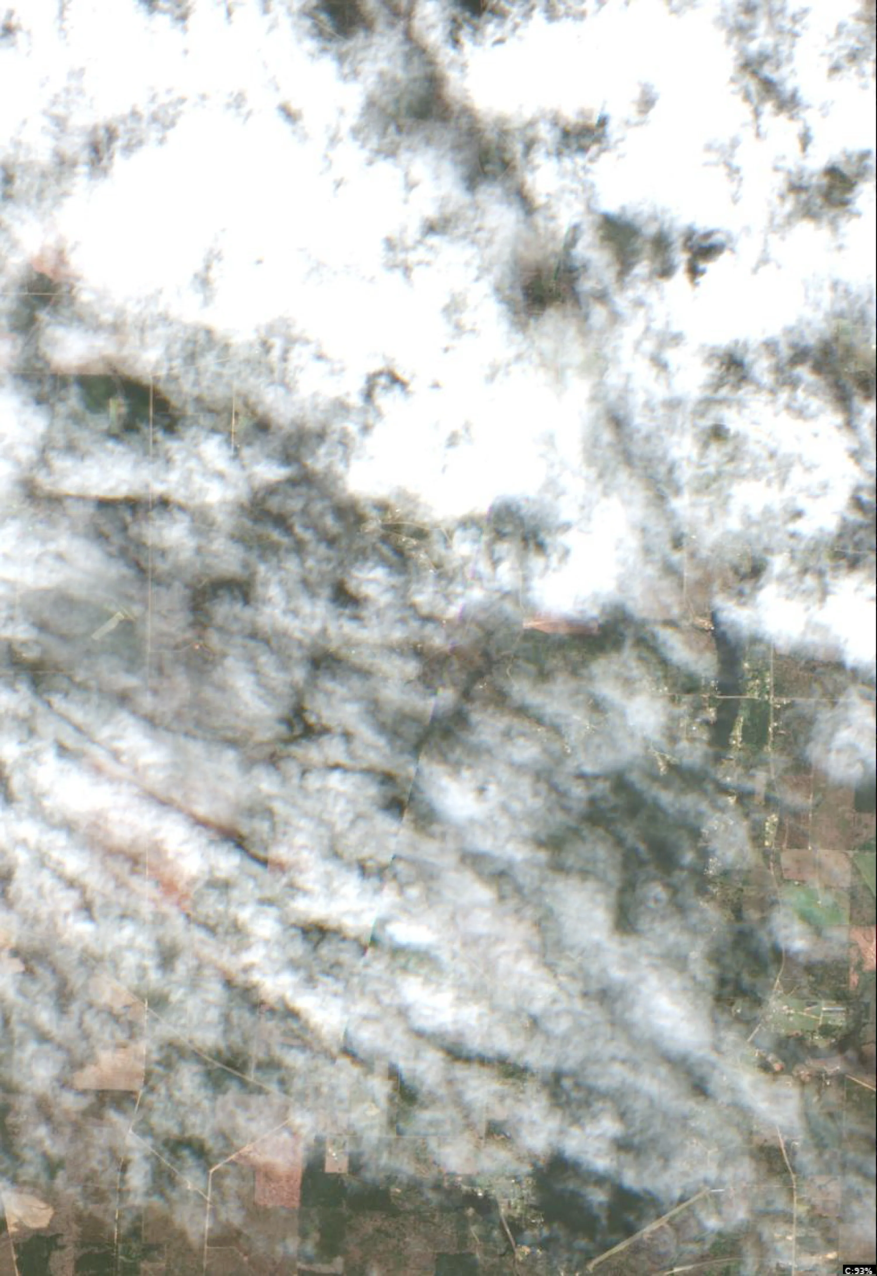
Lake Erling Satellite Analysis (Feb 6, 2026, 44°F - Winter/Pre-Spawn Focus)
1. LAKE OVERVIEW (Natural Sections & Landmarks)
Lake Erling is an irregularly shaped reservoir with a large central main lake body flanked by distinct arms. The overall shape resembles a wide "V" opening southward, narrowing northward.
- Main lake body: Central open water area, widest east-west, with tan-field shorelines and scattered wooded edges.
- Northern section/arm: Narrow, elongated arm extending north from the main body, lined with dense woods on both shores and agricultural fields to the west.
- Southern section/arm: Wider basin south of the main body, with open field shorelines and a few shallow coves visible as lighter water patches.
- Eastern arm: Prominent, creek-like arm jutting east from the main lake, with irregular shorelines, multiple points, and wooded coves.
- Western arm: Shorter, subtler extension west from the northern main lake, mostly field-lined with a few docks.
Major landmarks visible:
- Boat ramp on the western shore of the main lake body (gravel strip leading to water amid tan fields).
- Cluster of docks/marina in a northwest cove off the main lake (rectangular structures with boat slips, near wooded point).
- Road bridge crossing the narrow neck between northern arm and main lake (linear road over water constriction).
- No large islands visible; small wooded humps in eastern arm appear as darker green patches.
- Southern dam/outflow not clearly visible, but field roads lead to the southern tip.
The lake divides naturally at the northern narrows (bridge area) separating the northern arm from the main body, and via long points on the eastern arm creating cove pockets.
2. FINDABLE FISHING SPOTS
Here are 6 high-priority, findable spots based on visible structure (points, docks, color transitions), cover (docks, wooded edges), and winter patterns (channel-like arms, deep-water adjacent points). Ranked 1-10 using structure/cover complexity, depth transition (color gradients from light tan/shallow to darker water), seasonal fit (pre-spawn staging near channels/points), and wind protection.
-
Northern section - Main point just south of the road bridge (Priority: 9/10)
How to Find It: Launch from main lake boat ramp, head north past the western docks cluster, through the narrows by the road bridge; spot is the first big point on the east shore immediately south of bridge.
What You See: Prominent point with sharp color change (light tan to medium-dark water), wooded edge, and a few scattered docks.
Why Fish It: Point with drop-off transition holds pre-spawn bass/catfish staging from deep northern arm; docks add crappie cover.
Best Approach: Anchor or drift along the point edge with jigs or suspended baits for bass/crappie. -
Main lake body - Northwest cove with dock cluster (Priority: 8/10)
How to Find It: From main lake boat ramp, head northwest along western shore to the obvious cluster of rectangular docks in the protected cove.
What You See: Dense docks/boat houses with access paths, surrounded by darker water patches amid tan shallows, wooded point guarding cove mouth.
Why Fish It: Dock cover over moderate depth transitions ideal for winter crappie and bass; protected from wind.
Best Approach: Fish docks vertically with minnows/spider rigs for crappie, or skip baits under for bass. -
Eastern arm - Point at the wide cove mouth near wooded hump (Priority: 9/10)
How to Find It: From main lake, head east into the long arm; target the major point forming the mouth of the widest mid-arm cove, with a small dark green hump offshore.
What You See: Bold point with color gradient (tan flats to dark channel line), wooded shoreline, irregular dark patch (possible hump) in adjacent water.
Why Fish It: Channel-like arm with point/drop-off combo perfect for pre-spawn bass migrating to shallows; hump adds offshore structure.
Best Approach: Parallel the point with crankbaits or jigs, fan-cast to hump for catfish/bluegill. -
Main lake body - Eastern shore point opposite the boat ramp (Priority: 7/10)
How to Find It: Launch at western boat ramp, cross main lake east to the large protruding point directly across, marked by field edge and color shift.
What You See: Long point extending into open water with medium-dark water on deep side, tan shallows on shore side, no docks but clean geometry.
Why Fish It: Exposed point with visible depth break suits bass holding in transition zones; wind can concentrate baitfish.
Best Approach: Troll or cast along the color line with swimbaits for bass. -
Southern section - Protected cove on west shore behind field point (Priority: 8/10)
How to Find It: From main lake boat ramp, run south along western fields to the indented cove behind the first big tan point.
What You See: Sheltered cove with lighter water, a few linear dark laydowns from shore, darker water at mouth near point.
Why Fish It: Wind-protected with laydown cover near deeper main lake access; good for crappie and pre-spawn bass staging.
Best Approach: Pitch jigs to laydowns, work cove mouth for catfish. -
Northern section - East shore docks cluster in upper arm (Priority: 7/10)
How to Find It: Through northern narrows past bridge, hug east shore north to the group of 4-5 docks amid woods.
What You See: Linear docks along steep wooded bank, serpentine darker water line suggesting channel nearby.
Why Fish It: Deep arm channel bends with dock cover hold winter crappie and catfish.
Best Approach: Shoot baits under docks or drift channel edge.
3. VISIBLE FEATURES BY LAKE SECTION
Northern section: Narrow wooded arm with east shore docks cluster (mid-upper), road bridge at south end, main east point south of bridge (color transition), serpentine dark lines suggesting channels.
Main lake body: Western boat ramp (gravel to water), northwest dock cluster/cove, large east-west points (color gradients), open central water with tan shallows south.
Southern section: West shore coves with laydowns/points amid fields, wider open water with light tan patches (shallows), field roads along shores.
Eastern arm: Multiple points/coves with wooded edges, mid-arm wide cove with offshore dark hump, irregular shoreline creating drop-off lines.
Western arm: Field-lined with sparse docks, subtle points tying to main lake.
4. PRACTICAL FISHING GUIDANCE
Suggested fishing progression (winter 44°F, low-light starts, focus deep transitions early):
- Start (dawn/early): Northern section - main point south of road bridge (protected, quick access from ramp via narrows; target drop-off for staging bass).
- Mid-morning: Move to main lake body - northwest dock cluster (stay central as sun rises, hit crappie cover).
- Pattern: Northern arm early for deep refuge, transition to main lake points midday, eastern arm afternoon for channel bass. End in southern coves if wind picks up.
Navigation between sections:
- Northern to main lake: South through narrows by road bridge (short run).
- Main lake to eastern arm: East across open water to arm entrance (watch for points).
- Main lake to southern section: South along western shore past boat ramp (field-lined, easy visual).
- All spots accessible in 5-15 min from western boat ramp; hug shores for wind protection, use docks/points as beacons.
- Plan trips around major solunar periods for peak activity, minor periods offer secondary opportunities
- Day 1: High pressure (1019mb) - tougher bite, use finesse tactics
- Day 1: High winds (22mph) - seek protected areas, use heavier lures
- Day 1: Clear, High: 77°F, Low: 40°F
- Day 2: High pressure (1026mb) - tougher bite, use finesse tactics
- Day 2: High winds (22mph) - seek protected areas, use heavier lures
Tool analysis details
Lure Matrix Wind Clarity
Lure guidance for wind=windy, clarity=unknown.
Findings:
- Max thump: giant spinnerbaits, slow roll, contact cover
Analyze Satellite Imagery
Lake Erling Satellite Analysis (Feb 6, 2026, 44°F - Winter/Pre-Spawn Focus)
1. LAKE OVERVIEW (Natural Sections & Landmarks)
Lake Erling is an irregularly shaped reservoir with a large central main lake body flanked by distinct arms. The overall shape resembles a wide "V" opening southward, narrowing northward.
- Main lake body: Central open water area, widest east-west, with tan-field shorelines and scattered wooded edges.
- Northern section/arm: Narrow, elongated arm extending north from the main body, lined with dense woods on both shores and agricultural fields to the west.
- Southern section/arm: Wider basin south of the main body, with open field shorelines and a few shallow coves visible as lighter water patches.
- Eastern arm: Prominent, creek-like arm jutting east from the main lake, with irregular shorelines, multiple points, and wooded coves.
- Western arm: Shorter, subtler extension west from the northern main lake, mostly field-lined with a few docks.
Major landmarks visible:
- Boat ramp on the western shore of the main lake body (gravel strip leading to water amid tan fields).
- Cluster of docks/marina in a northwest cove off the main lake (rectangular structures with boat slips, near wooded point).
- Road bridge crossing the narrow neck between northern arm and main lake (linear road over water constriction).
- No large islands visible; small wooded humps in eastern arm appear as darker green patches.
- Southern dam/outflow not clearly visible, but field roads lead to the southern tip.
The lake divides naturally at the northern narrows (bridge area) separating the northern arm from the main body, and via long points on the eastern arm creating cove pockets.
2. FINDABLE FISHING SPOTS
Here are 6 high-priority, findable spots based on visible structure (points, docks, color transitions), cover (docks, wooded edges), and winter patterns (channel-like arms, deep-water adjacent points). Ranked 1-10 using structure/cover complexity, depth transition (color gradients from light tan/shallow to darker water), seasonal fit (pre-spawn staging near channels/points), and wind protection.
-
Northern section - Main point just south of the road bridge (Priority: 9/10)
How to Find It: Launch from main lake boat ramp, head north past the western docks cluster, through the narrows by the road bridge; spot is the first big point on the east shore immediately south of bridge.
What You See: Prominent point with sharp color change (light tan to medium-dark water), wooded edge, and a few scattered docks.
Why Fish It: Point with drop-off transition holds pre-spawn bass/catfish staging from deep northern arm; docks add crappie cover.
Best Approach: Anchor or drift along the point edge with jigs or suspended baits for bass/crappie. -
Main lake body - Northwest cove with dock cluster (Priority: 8/10)
How to Find It: From main lake boat ramp, head northwest along western shore to the obvious cluster of rectangular docks in the protected cove.
What You See: Dense docks/boat houses with access paths, surrounded by darker water patches amid tan shallows, wooded point guarding cove mouth.
Why Fish It: Dock cover over moderate depth transitions ideal for winter crappie and bass; protected from wind.
Best Approach: Fish docks vertically with minnows/spider rigs for crappie, or skip baits under for bass. -
Eastern arm - Point at the wide cove mouth near wooded hump (Priority: 9/10)
How to Find It: From main lake, head east into the long arm; target the major point forming the mouth of the widest mid-arm cove, with a small dark green hump offshore.
What You See: Bold point with color gradient (tan flats to dark channel line), wooded shoreline, irregular dark patch (possible hump) in adjacent water.
Why Fish It: Channel-like arm with point/drop-off combo perfect for pre-spawn bass migrating to shallows; hump adds offshore structure.
Best Approach: Parallel the point with crankbaits or jigs, fan-cast to hump for catfish/bluegill. -
Main lake body - Eastern shore point opposite the boat ramp (Priority: 7/10)
How to Find It: Launch at western boat ramp, cross main lake east to the large protruding point directly across, marked by field edge and color shift.
What You See: Long point extending into open water with medium-dark water on deep side, tan shallows on shore side, no docks but clean geometry.
Why Fish It: Exposed point with visible depth break suits bass holding in transition zones; wind can concentrate baitfish.
Best Approach: Troll or cast along the color line with swimbaits for bass. -
Southern section - Protected cove on west shore behind field point (Priority: 8/10)
How to Find It: From main lake boat ramp, run south along western fields to the indented cove behind the first big tan point.
What You See: Sheltered cove with lighter water, a few linear dark laydowns from shore, darker water at mouth near point.
Why Fish It: Wind-protected with laydown cover near deeper main lake access; good for crappie and pre-spawn bass staging.
Best Approach: Pitch jigs to laydowns, work cove mouth for catfish. -
Northern section - East shore docks cluster in upper arm (Priority: 7/10)
How to Find It: Through northern narrows past bridge, hug east shore north to the group of 4-5 docks amid woods.
What You See: Linear docks along steep wooded bank, serpentine darker water line suggesting channel nearby.
Why Fish It: Deep arm channel bends with dock cover hold winter crappie and catfish.
Best Approach: Shoot baits under docks or drift channel edge.
3. VISIBLE FEATURES BY LAKE SECTION
Northern section: Narrow wooded arm with east shore docks cluster (mid-upper), road bridge at south end, main east point south of bridge (color transition), serpentine dark lines suggesting channels.
Main lake body: Western boat ramp (gravel to water), northwest dock cluster/cove, large east-west points (color gradients), open central water with tan shallows south.
Southern section: West shore coves with laydowns/points amid fields, wider open water with light tan patches (shallows), field roads along shores.
Eastern arm: Multiple points/coves with wooded edges, mid-arm wide cove with offshore dark hump, irregular shoreline creating drop-off lines.
Western arm: Field-lined with sparse docks, subtle points tying to main lake.
4. PRACTICAL FISHING GUIDANCE
Suggested fishing progression (winter 44°F, low-light starts, focus deep transitions early):
- Start (dawn/early): Northern section - main point south of road bridge (protected, quick access from ramp via narrows; target drop-off for staging bass).
- Mid-morning: Move to main lake body - northwest dock cluster (stay central as sun rises, hit crappie cover).
- Pattern: Northern arm early for deep refuge, transition to main lake points midday, eastern arm afternoon for channel bass. End in southern coves if wind picks up.
Navigation between sections:
- Northern to main lake: South through narrows by road bridge (short run).
- Main lake to eastern arm: East across open water to arm entrance (watch for points).
- Main lake to southern section: South along western shore past boat ramp (field-lined, easy visual).
- All spots accessible in 5-15 min from western boat ramp; hug shores for wind protection, use docks/points as beacons.
Findings:
-
Lake Erling Satellite Analysis (Feb 6, 2026, 44°F - Winter/Pre-Spawn Focus)
1. LAKE OVERVIEW (Natural Sections & Landmarks)
Lake Erling is an irregularly shaped reservoir with a large central main lake body flanked by distinct arms. The overall shape resembles a wide "V" opening southward, narrowing northward.
- Main lake body: Central open water area, widest east-west, with tan-field shorelines and scattered wooded edges.
- Northern section/arm: Narrow, elongated arm extending north from the main body, lined with dense woods on both shores and agricultural fields to the west.
- Southern section/arm: Wider basin south of the main body, with open field shorelines and a few shallow coves visible as lighter water patches.
- Eastern arm: Prominent, creek-like arm jutting east from the main lake, with irregular shorelines, multiple points, and wooded coves.
- Western arm: Shorter, subtler extension west from the northern main lake, mostly field-lined with a few docks.
Major landmarks visible:
- Boat ramp on the western shore of the main lake body (gravel strip leading to water amid tan fields).
- Cluster of docks/marina in a northwest cove off the main lake (rectangular structures with boat slips, near wooded point).
- Road bridge crossing the narrow neck between northern arm and main lake (linear road over water constriction).
- No large islands visible; small wooded humps in eastern arm appear as darker green patches.
- Southern dam/outflow not clearly visible, but field roads lead to the southern tip.
The lake divides naturally at the northern narrows (bridge area) separating the northern arm from the main body, and via long points on the eastern arm creating cove pockets.
2. FINDABLE FISHING SPOTS
Here are 6 high-priority, findable spots based on visible structure (points, docks, color transitions), cover (docks, wooded edges), and winter patterns (channel-like arms, deep-water adjacent points). Ranked 1-10 using structure/cover complexity, depth transition (color gradients from light tan/shallow to darker water), seasonal fit (pre-spawn staging near channels/points), and wind protection.
-
Northern section - Main point just south of the road bridge (Priority: 9/10)
How to Find It: Launch from main lake boat ramp, head north past the western docks cluster, through the narrows by the road bridge; spot is the first big point on the east shore immediately south of bridge.
What You See: Prominent point with sharp color change (light tan to medium-dark water), wooded edge, and a few scattered docks.
Why Fish It: Point with drop-off transition holds pre-spawn bass/catfish staging from deep northern arm; docks add crappie cover.
Best Approach: Anchor or drift along the point edge with jigs or suspended baits for bass/crappie. -
Main lake body - Northwest cove with dock cluster (Priority: 8/10)
How to Find It: From main lake boat ramp, head northwest along western shore to the obvious cluster of rectangular docks in the protected cove.
What You See: Dense docks/boat houses with access paths, surrounded by darker water patches amid tan shallows, wooded point guarding cove mouth.
Why Fish It: Dock cover over moderate depth transitions ideal for winter crappie and bass; protected from wind.
Best Approach: Fish docks vertically with minnows/spider rigs for crappie, or skip baits under for bass. -
Eastern arm - Point at the wide cove mouth near wooded hump (Priority: 9/10)
How to Find It: From main lake, head east into the long arm; target the major point forming the mouth of the widest mid-arm cove, with a small dark green hump offshore.
What You See: Bold point with color gradient (tan flats to dark channel line), wooded shoreline, irregular dark patch (possible hump) in adjacent water.
Why Fish It: Channel-like arm with point/drop-off combo perfect for pre-spawn bass migrating to shallows; hump adds offshore structure.
Best Approach: Parallel the point with crankbaits or jigs, fan-cast to hump for catfish/bluegill. -
Main lake body - Eastern shore point opposite the boat ramp (Priority: 7/10)
How to Find It: Launch at western boat ramp, cross main lake east to the large protruding point directly across, marked by field edge and color shift.
What You See: Long point extending into open water with medium-dark water on deep side, tan shallows on shore side, no docks but clean geometry.
Why Fish It: Exposed point with visible depth break suits bass holding in transition zones; wind can concentrate baitfish.
Best Approach: Troll or cast along the color line with swimbaits for bass. -
Southern section - Protected cove on west shore behind field point (Priority: 8/10)
How to Find It: From main lake boat ramp, run south along western fields to the indented cove behind the first big tan point.
What You See: Sheltered cove with lighter water, a few linear dark laydowns from shore, darker water at mouth near point.
Why Fish It: Wind-protected with laydown cover near deeper main lake access; good for crappie and pre-spawn bass staging.
Best Approach: Pitch jigs to laydowns, work cove mouth for catfish. -
Northern section - East shore docks cluster in upper arm (Priority: 7/10)
How to Find It: Through northern narrows past bridge, hug east shore north to the group of 4-5 docks amid woods.
What You See: Linear docks along steep wooded bank, serpentine darker water line suggesting channel nearby.
Why Fish It: Deep arm channel bends with dock cover hold winter crappie and catfish.
Best Approach: Shoot baits under docks or drift channel edge.
3. VISIBLE FEATURES BY LAKE SECTION
Northern section: Narrow wooded arm with east shore docks cluster (mid-upper), road bridge at south end, main east point south of bridge (color transition), serpentine dark lines suggesting channels.
Main lake body: Western boat ramp (gravel to water), northwest dock cluster/cove, large east-west points (color gradients), open central water with tan shallows south.
Southern section: West shore coves with laydowns/points amid fields, wider open water with light tan patches (shallows), field roads along shores.
Eastern arm: Multiple points/coves with wooded edges, mid-arm wide cove with offshore dark hump, irregular shoreline creating drop-off lines.
Western arm: Field-lined with sparse docks, subtle points tying to main lake.
4. PRACTICAL FISHING GUIDANCE
Suggested fishing progression (winter 44°F, low-light starts, focus deep transitions early):
- Start (dawn/early): Northern section - main point south of road bridge (protected, quick access from ramp via narrows; target drop-off for staging bass).
- Mid-morning: Move to main lake body - northwest dock cluster (stay central as sun rises, hit crappie cover).
- Pattern: Northern arm early for deep refuge, transition to main lake points midday, eastern arm afternoon for channel bass. End in southern coves if wind picks up.
Navigation between sections:
- Northern to main lake: South through narrows by road bridge (short run).
- Main lake to eastern arm: East across open water to arm entrance (watch for points).
- Main lake to southern section: South along western shore past boat ramp (field-lined, easy visual).
- All spots accessible in 5-15 min from western boat ramp; hug shores for wind protection, use docks/points as beacons.
Analyze Solunar Timing
Solunar timing analysis for Lake Erling completed
Findings:
- Plan trips around major solunar periods for peak activity, minor periods offer secondary opportunities
Analyze Weather Conditions
Weather analysis for Lake Erling completed
Findings:
- Day 1: High pressure (1019mb) - tougher bite, use finesse tactics
- Day 1: High winds (22mph) - seek protected areas, use heavier lures
- Day 1: Clear, High: 77°F, Low: 40°F
- Day 2: High pressure (1026mb) - tougher bite, use finesse tactics
- Day 2: High winds (22mph) - seek protected areas, use heavier lures
Analyze Thermal Patterns
Overall Thermal Landscape Summary
Assuming North is at the top of the image, East to the right, West to the left, and South at the bottom (standard orientation for satellite imagery). The lake has an elongated, irregular shape resembling a winding river channel with a prominent wide basin in the central-eastern quadrant and narrower arms extending northwest, northeast, and south from it. Major visual anchors include: (1) the large, roughly oval-shaped wide basin occupying the central-right area (about 40% of the image width), (2) the narrow, sinuous northwest arm extending leftward from the basin's northwest edge like a hooked finger, and (3) the short southern protrusion jutting down from the basin's southeast corner. Dominant colors are Dark Blue to Medium Blue across water areas, with minor Light Blue patches. Approximate min/max surface temperatures: Very Dark Navy Blue pockets at 40-42°F (4-6°C) to Light Blue areas at 52-56°F (11-13°C). Land areas (darker blobs along shorelines) are ignored.
Detailed Thermal Feature Analysis
Temperature Breaks
Clearly visible abrupt transitions are limited due to overall uniformity. One notable break occurs along the eastern edge of the wide central basin, where Dark Blue (42-46°F / 6-8°C) sharply meets Medium Blue (46-52°F / 8-11°C) in a narrow, linear band running north-south parallel to the shoreline. Another subtle break is at the junction where the northwest arm meets the basin, with Dark Blue transitioning to slightly lighter Medium Blue over a short distance.
Pockets/Patches
Small, isolated Light Blue patches (52-56°F / 11-13°C) are visible within the wide central basin, specifically two circular patches: one near the basin's center, south of the northwest arm junction, and another smaller one hugging the southeastern shoreline inside the basin. No warmer pockets (e.g., green/yellow) are distinguishable.
Gradients
Gradual gradients are present in the northwest arm, transitioning from Very Dark Navy Blue (40-42°F / 4-6°C) at the far northwest tip to Dark Blue (42-46°F / 6-8°C) toward the basin. A milder gradient spans the southern protrusion, from Medium Blue near the basin to Dark Blue at the tip.
Uniform Areas
The majority of the lake shows uniform Dark Blue (42-46°F / 6-8°C) coloring, particularly the entire northeast arm, most of the northwest arm, and the outer edges of the wide central basin. These areas lack clear internal variation.
Insightful Fish Behavior Interpretation
Surface temperatures are predominantly cold (Dark Blue to Medium Blue, 42-52°F / 6-11°C), indicating late winter/early spring conditions where fish activity is very slow and structure-oriented, with minimal surface feeding. Fish are likely holding tight to shorelines or features in uniform Dark Blue zones for stability, showing long but subtle feeding windows. The Light Blue patches (52-56°F / 11-13°C) in the central basin suggest slightly increased activity, drawing fish for pre-spawn staging and following these warmer surface pockets. Temperature breaks, like the eastern basin edge, are prime transition zones where fish may congregate to exploit the 4-6°F (2-3°C) shift for ambush feeding at the surface. Overall, expect sluggish surface behavior, with fish favoring breaks and warmer patches over uniform cold areas.
Satellite Correlation Analysis
No additional standard satellite imagery (e.g., visible light photos) is provided alongside the thermal data, so no correlations to inflows, outflows, springs, or surface structures can be made. Thermal patterns appear driven by shoreline geometry, with subtle warming in the sheltered central basin possibly due to reduced wind mixing or shallow flats (visible as smoother water boundaries), while narrower arms remain cooler.
Actionable Fishing Recommendations
- Prioritize the wide central basin: Target the two Light Blue patches (52-56°F / 11-13°C)—the central one south of the northwest arm junction and the southeastern shoreline patch—for surface lures or slow presentations, as these warmer zones likely hold staging fish.
- Work temperature breaks: Drift or cast along the eastern basin edge break (Dark to Medium Blue transition) and the northwest arm-basin junction, using jigs or suspended baits to cover the color shift where fish may stage.
- Avoid uniform cold zones: Skip the dark-uniform northwest and northeast arms unless accessing structure; fish surface activity will be minimal there (42-46°F / 6-8°C).
- Tactics: Use slow retrieves in 42-52°F (6-11°C) water; focus dawn/dusk for any surface bites. Shoreline access near basin anchors recommended. Image quality shows clear but subtle patterns—confirm on-site with electronics.
Findings:
- Current surface temperature: 44.0°F. Fish metabolism significantly reduced in cold water. Target sunny, protected shorelines and use extremely slow presentations. Focus on midday when surface temperatures are warmest.
-
Overall Thermal Landscape Summary
Assuming North is at the top of the image, East to the right, West to the left, and South at the bottom (standard orientation for satellite imagery). The lake has an elongated, irregular shape resembling a winding river channel with a prominent wide basin in the central-eastern quadrant and narrower arms extending northwest, northeast, and south from it. Major visual anchors include: (1) the large, roughly oval-shaped wide basin occupying the central-right area (about 40% of the image width), (2) the narrow, sinuous northwest arm extending leftward from the basin's northwest edge like a hooked finger, and (3) the short southern protrusion jutting down from the basin's southeast corner. Dominant colors are Dark Blue to Medium Blue across water areas, with minor Light Blue patches. Approximate min/max surface temperatures: Very Dark Navy Blue pockets at 40-42°F (4-6°C) to Light Blue areas at 52-56°F (11-13°C). Land areas (darker blobs along shorelines) are ignored.
Detailed Thermal Feature Analysis
Temperature Breaks
Clearly visible abrupt transitions are limited due to overall uniformity. One notable break occurs along the eastern edge of the wide central basin, where Dark Blue (42-46°F / 6-8°C) sharply meets Medium Blue (46-52°F / 8-11°C) in a narrow, linear band running north-south parallel to the shoreline. Another subtle break is at the junction where the northwest arm meets the basin, with Dark Blue transitioning to slightly lighter Medium Blue over a short distance.
Pockets/Patches
Small, isolated Light Blue patches (52-56°F / 11-13°C) are visible within the wide central basin, specifically two circular patches: one near the basin's center, south of the northwest arm junction, and another smaller one hugging the southeastern shoreline inside the basin. No warmer pockets (e.g., green/yellow) are distinguishable.
Gradients
Gradual gradients are present in the northwest arm, transitioning from Very Dark Navy Blue (40-42°F / 4-6°C) at the far northwest tip to Dark Blue (42-46°F / 6-8°C) toward the basin. A milder gradient spans the southern protrusion, from Medium Blue near the basin to Dark Blue at the tip.
Uniform Areas
The majority of the lake shows uniform Dark Blue (42-46°F / 6-8°C) coloring, particularly the entire northeast arm, most of the northwest arm, and the outer edges of the wide central basin. These areas lack clear internal variation.
Insightful Fish Behavior Interpretation
Surface temperatures are predominantly cold (Dark Blue to Medium Blue, 42-52°F / 6-11°C), indicating late winter/early spring conditions where fish activity is very slow and structure-oriented, with minimal surface feeding. Fish are likely holding tight to shorelines or features in uniform Dark Blue zones for stability, showing long but subtle feeding windows. The Light Blue patches (52-56°F / 11-13°C) in the central basin suggest slightly increased activity, drawing fish for pre-spawn staging and following these warmer surface pockets. Temperature breaks, like the eastern basin edge, are prime transition zones where fish may congregate to exploit the 4-6°F (2-3°C) shift for ambush feeding at the surface. Overall, expect sluggish surface behavior, with fish favoring breaks and warmer patches over uniform cold areas.
Satellite Correlation Analysis
No additional standard satellite imagery (e.g., visible light photos) is provided alongside the thermal data, so no correlations to inflows, outflows, springs, or surface structures can be made. Thermal patterns appear driven by shoreline geometry, with subtle warming in the sheltered central basin possibly due to reduced wind mixing or shallow flats (visible as smoother water boundaries), while narrower arms remain cooler.
Actionable Fishing Recommendations
- Prioritize the wide central basin: Target the two Light Blue patches (52-56°F / 11-13°C)—the central one south of the northwest arm junction and the southeastern shoreline patch—for surface lures or slow presentations, as these warmer zones likely hold staging fish.
- Work temperature breaks: Drift or cast along the eastern basin edge break (Dark to Medium Blue transition) and the northwest arm-basin junction, using jigs or suspended baits to cover the color shift where fish may stage.
- Avoid uniform cold zones: Skip the dark-uniform northwest and northeast arms unless accessing structure; fish surface activity will be minimal there (42-46°F / 6-8°C).
- Tactics: Use slow retrieves in 42-52°F (6-11°C) water; focus dawn/dusk for any surface bites. Shoreline access near basin anchors recommended. Image quality shows clear but subtle patterns—confirm on-site with electronics.
- Winter surface patterns: Target the warmest surface areas during midday, typically along north-facing shorelines and sun-exposed areas. Use slow presentations as fish metabolism is reduced.
Analyze Pressure Trends
Barometric pressure analysis for Lake Erling: falling trend at 1019.00mb
Findings:
- Falling pressure trend detected (1019.00 → lower). Fish will be more active - excellent feeding windows ahead!
- Target shallow areas, use aggressive presentations. Fish are actively feeding.
Analyze Water Clarity
1. Overall Water Quality Summary
The imagery reveals a lake dominated by moderate-to-high chlorophyll levels (prevalent green hues in the first image) overlaid with widespread high sediment loading (extensive brown/tan coverage in the second image), translating to top-center matrix conditions (brown/green mix: moderate chlorophyll + high sediment) across much of the lake. Clearer pockets (dark blue/teal in first image correlating with lighter/white patches in second) indicate isolated bottom-left quadrant areas (low sediment + low chlorophyll), while no strong yellow/red high-chlorophyll/low-sediment zones are evident. General visibility ranges from 1-4 feet in dominant stained zones to 8-15 feet in minor clear pockets, suggesting challenging but fishable conditions with productivity concentrated at color transitions.
2. Detailed Clarity Zone Mapping & Characterization (3-5 Key Zones with locations, categories, causes)
Zone 1: Northwest Arm (Top-left quadrant of both images)
- Matrix Position Analysis: Green in first image (bottom-center: moderate chlorophyll + low sediment) meets dark brown in second (top-left/top-center: low-moderate chlorophyll + high sediment) → combined top-center (brown/green mix).
- Combined Conditions: Moderate chlorophyll + high sediment = 1-4 feet visibility; stained productive water from stirred shallows and inflows.
- Location Mapping: Elongated northwest arm, from the broad northern inlet southward to the first major bend.
- Tactical Implications: Challenging visibility requires vibration-heavy tactics; target structure edges.
Zone 2: Central Basin (Central mass in both images)
- Matrix Position Analysis: Patchy green-to-dark blue in first (bottom-center to bottom-left) with solid tan/brown in second (top-center) → dominant top-center (brown/green mix), minor bottom-left where white patches align.
- Combined Conditions: Moderate chlorophyll + high sediment in core (1-4 feet visibility); isolated low sediment/low chlorophyll pockets (15-25+ feet where teal/white overlap).
- Location Mapping: Main central basin, widest east-west section south of northwest arm, including scattered white spots near eastern midpoint.
- Tactical Implications: Finesse in white/teal pockets, power fish brown/green core; high productivity at internal edges.
Zone 3: Southeast Extension (Lower-right extensions in both images)
- Matrix Position Analysis: Bright green fingers in first (bottom-center) over dark brown/reddish mix in second (top-right/top-center) → top-right (dark brown/red mix: high chlorophyll + high sediment).
- Combined Conditions: High chlorophyll + high sediment = <2 feet visibility; worst conditions from combined algae and particles.
- Location Mapping: Narrow southeast arm and adjacent eastern shore, protruding from central basin.
- Tactical Implications: Sound/vibration-only approaches; fish blindly near visible structure.
Zone 4: Southwestern Pocket (Lower-left patch in both images)
- Matrix Position Analysis: Darker teal edges in first (bottom-left) with lighter tan/white in second → bottom-left (dark blue/teal: low sediment + low chlorophyll).
- Combined Conditions: Minimal particles + minimal algae = 15-25+ feet visibility; premium clear water refuge.
- Location Mapping: Isolated southwestern cove/bay, west of central basin near the southern shoreline curve.
- Tactical Implications: Stealth finesse essential; sight-fishing potential.
Zone 5: Northeastern Inlet (Upper-right small green blob in first, tan in second)
- Matrix Position Analysis: Concentrated green (bottom-center) to brown (top-center) → top-center (brown/green mix).
- Combined Conditions: Moderate chlorophyll + high sediment = 1-4 feet visibility.
- Location Mapping: Narrow northeastern inlet arm, east of northwest arm.
- Tactical Implications: Reaction baits at inflow edges.
3. Turbidity/Algae Sources & Transition Zones Analysis
Source Identification (Visual): High sediment (brown/tan dominance in second image) originates from northern inflows (darkest browns at northwest/northeast arms, suggesting runoff entry points) and wind-stirred shallows (solid tan in central/southeast). Moderate-high chlorophyll (green coverage in first image) concentrates in protected northwest/central areas and southeast fingers, likely from nutrient loading at inlets or stagnant coves. No yellow/red blooms indicate algae tied to sediment rather than isolated growth.
Clarity Breaks/Edges:
- Sharp mudline (brown-to-teal transition) along eastern central basin edge, running north-south where second image white meets brown—prime ambush point as clearer water draws baitfish.
- Gradual green-to-dark blue fade in northwest arm (first image), blending top-center to bottom-left—high productivity edge for staging fish.
- Distinct tan-to-dark brown wall in southeast extension (second image), marking sediment buildup—bait concentration zone. These edges signify "turbidity walls" where fish hold from stained side ambushing into clearer water, amplified by current temp (44°F) slowing metabolism.
4. Species-Specific Clarity Strategy (Recommendations tied to zones)
- Bass: Target Zone 1 (northwest arm top-center edges) and Zone 3 (southeast top-right transitions) for reaction strikes in stained water; patrol clarity breaks like central basin mudline (Zone 2) ambushing from brown/green into teal pockets.
- Crappie: Suspend near cover in Zone 4 (southwestern bottom-left clear pocket) for sight-feeding; finesse edges of Zone 5 northeastern inlet where moderate staining holds schools.
- Walleye/Catfish: Hug bottom in low-visibility Zone 3 (southeast <2ft) and Zone 2 central brown core, using structure in high-sediment areas; drift transitions like northwest arm green-to-teal for nocturnal/low-light activity.
- Generic: All species concentrate at identified edges (e.g., eastern mudline, northwest fade) where clarity shifts concentrate forage.
5. Tactical Fishing Adjustments (Lures/Presentations tied to zones)
Zone 1 (Northwest Arm, Top-Center, 1-4ft): Bright chartreuse/white chatterbaits or 1/2oz spinnerbaits with loud rattles; slow-aggressive retrieves to trigger cold-water reactions—long casts (20-30yds), 12-15lb fluoro/mono. Fish edges parallel to green-brown break.
Zone 2 (Central Basin, Top-Center/Bottom-Left, 1-4ft to 15+ft): In brown/green core, lipless crankbaits (bright blue/chartreuse) with vibration; switch to natural green pumpkin jigs in teal/white pockets—finesse slow drags. Power-finesse transition at mudline with yo-yo retrieves.
Zone 3 (Southeast, Top-Right, <2ft): Big worms or swimbaits (black/blue high-contrast) on heavy vibration rigs; dead-stick or mega-slow with rattles—braid 15-20lb, close 10-20yd casts. Drift blindly along tan-brown wall.
Zone 4 (Southwest, Bottom-Left, 15+ft): Small Ned rigs or drop shots (watermelon/green pumpkin naturals); ultra-slow finesse, 40+yd casts with 8-12lb fluoro, spotter positioning 50+yds off.
Zone 5 (Northeast, Top-Center, 1-4ft): Bright blue crankbaits at inflow; steady retrieve upsized 25% for cold water.
Clarity Breaks General: Parallel casts along edges (e.g., eastern mudline), alternating power (fast vibration) from stained side and finesse (slow scent) into clear—key for 44°F sluggish fish.
6. Seasonal Context (Interpretation of visual patterns)
The widespread brown/green staining (top-center dominance) with northern inflow turbidity and central/southwestern clear refugia appears consistent with post-storm or wind-event disruption, where sediment resuspension overwhelms moderate algae growth—unusual extent of high-sediment coverage suggests recent disturbance rather than stable seasonal bloom. Deep teal/white pockets in southwest/central maintain resilience, indicating deeper basin stratification preserves clarity amid surface turbidity; cold 44°F temp aligns with fish hugging these clearer deep edges over stained shallows.
Findings:
-
1. Overall Water Quality Summary
The imagery reveals a lake dominated by moderate-to-high chlorophyll levels (prevalent green hues in the first image) overlaid with widespread high sediment loading (extensive brown/tan coverage in the second image), translating to top-center matrix conditions (brown/green mix: moderate chlorophyll + high sediment) across much of the lake. Clearer pockets (dark blue/teal in first image correlating with lighter/white patches in second) indicate isolated bottom-left quadrant areas (low sediment + low chlorophyll), while no strong yellow/red high-chlorophyll/low-sediment zones are evident. General visibility ranges from 1-4 feet in dominant stained zones to 8-15 feet in minor clear pockets, suggesting challenging but fishable conditions with productivity concentrated at color transitions.
2. Detailed Clarity Zone Mapping & Characterization (3-5 Key Zones with locations, categories, causes)
Zone 1: Northwest Arm (Top-left quadrant of both images)
- Matrix Position Analysis: Green in first image (bottom-center: moderate chlorophyll + low sediment) meets dark brown in second (top-left/top-center: low-moderate chlorophyll + high sediment) → combined top-center (brown/green mix).
- Combined Conditions: Moderate chlorophyll + high sediment = 1-4 feet visibility; stained productive water from stirred shallows and inflows.
- Location Mapping: Elongated northwest arm, from the broad northern inlet southward to the first major bend.
- Tactical Implications: Challenging visibility requires vibration-heavy tactics; target structure edges.
Zone 2: Central Basin (Central mass in both images)
- Matrix Position Analysis: Patchy green-to-dark blue in first (bottom-center to bottom-left) with solid tan/brown in second (top-center) → dominant top-center (brown/green mix), minor bottom-left where white patches align.
- Combined Conditions: Moderate chlorophyll + high sediment in core (1-4 feet visibility); isolated low sediment/low chlorophyll pockets (15-25+ feet where teal/white overlap).
- Location Mapping: Main central basin, widest east-west section south of northwest arm, including scattered white spots near eastern midpoint.
- Tactical Implications: Finesse in white/teal pockets, power fish brown/green core; high productivity at internal edges.
Zone 3: Southeast Extension (Lower-right extensions in both images)
- Matrix Position Analysis: Bright green fingers in first (bottom-center) over dark brown/reddish mix in second (top-right/top-center) → top-right (dark brown/red mix: high chlorophyll + high sediment).
- Combined Conditions: High chlorophyll + high sediment = <2 feet visibility; worst conditions from combined algae and particles.
- Location Mapping: Narrow southeast arm and adjacent eastern shore, protruding from central basin.
- Tactical Implications: Sound/vibration-only approaches; fish blindly near visible structure.
Zone 4: Southwestern Pocket (Lower-left patch in both images)
- Matrix Position Analysis: Darker teal edges in first (bottom-left) with lighter tan/white in second → bottom-left (dark blue/teal: low sediment + low chlorophyll).
- Combined Conditions: Minimal particles + minimal algae = 15-25+ feet visibility; premium clear water refuge.
- Location Mapping: Isolated southwestern cove/bay, west of central basin near the southern shoreline curve.
- Tactical Implications: Stealth finesse essential; sight-fishing potential.
Zone 5: Northeastern Inlet (Upper-right small green blob in first, tan in second)
- Matrix Position Analysis: Concentrated green (bottom-center) to brown (top-center) → top-center (brown/green mix).
- Combined Conditions: Moderate chlorophyll + high sediment = 1-4 feet visibility.
- Location Mapping: Narrow northeastern inlet arm, east of northwest arm.
- Tactical Implications: Reaction baits at inflow edges.
3. Turbidity/Algae Sources & Transition Zones Analysis
Source Identification (Visual): High sediment (brown/tan dominance in second image) originates from northern inflows (darkest browns at northwest/northeast arms, suggesting runoff entry points) and wind-stirred shallows (solid tan in central/southeast). Moderate-high chlorophyll (green coverage in first image) concentrates in protected northwest/central areas and southeast fingers, likely from nutrient loading at inlets or stagnant coves. No yellow/red blooms indicate algae tied to sediment rather than isolated growth.
Clarity Breaks/Edges:
- Sharp mudline (brown-to-teal transition) along eastern central basin edge, running north-south where second image white meets brown—prime ambush point as clearer water draws baitfish.
- Gradual green-to-dark blue fade in northwest arm (first image), blending top-center to bottom-left—high productivity edge for staging fish.
- Distinct tan-to-dark brown wall in southeast extension (second image), marking sediment buildup—bait concentration zone. These edges signify "turbidity walls" where fish hold from stained side ambushing into clearer water, amplified by current temp (44°F) slowing metabolism.
4. Species-Specific Clarity Strategy (Recommendations tied to zones)
- Bass: Target Zone 1 (northwest arm top-center edges) and Zone 3 (southeast top-right transitions) for reaction strikes in stained water; patrol clarity breaks like central basin mudline (Zone 2) ambushing from brown/green into teal pockets.
- Crappie: Suspend near cover in Zone 4 (southwestern bottom-left clear pocket) for sight-feeding; finesse edges of Zone 5 northeastern inlet where moderate staining holds schools.
- Walleye/Catfish: Hug bottom in low-visibility Zone 3 (southeast <2ft) and Zone 2 central brown core, using structure in high-sediment areas; drift transitions like northwest arm green-to-teal for nocturnal/low-light activity.
- Generic: All species concentrate at identified edges (e.g., eastern mudline, northwest fade) where clarity shifts concentrate forage.
5. Tactical Fishing Adjustments (Lures/Presentations tied to zones)
Zone 1 (Northwest Arm, Top-Center, 1-4ft): Bright chartreuse/white chatterbaits or 1/2oz spinnerbaits with loud rattles; slow-aggressive retrieves to trigger cold-water reactions—long casts (20-30yds), 12-15lb fluoro/mono. Fish edges parallel to green-brown break.
Zone 2 (Central Basin, Top-Center/Bottom-Left, 1-4ft to 15+ft): In brown/green core, lipless crankbaits (bright blue/chartreuse) with vibration; switch to natural green pumpkin jigs in teal/white pockets—finesse slow drags. Power-finesse transition at mudline with yo-yo retrieves.
Zone 3 (Southeast, Top-Right, <2ft): Big worms or swimbaits (black/blue high-contrast) on heavy vibration rigs; dead-stick or mega-slow with rattles—braid 15-20lb, close 10-20yd casts. Drift blindly along tan-brown wall.
Zone 4 (Southwest, Bottom-Left, 15+ft): Small Ned rigs or drop shots (watermelon/green pumpkin naturals); ultra-slow finesse, 40+yd casts with 8-12lb fluoro, spotter positioning 50+yds off.
Zone 5 (Northeast, Top-Center, 1-4ft): Bright blue crankbaits at inflow; steady retrieve upsized 25% for cold water.
Clarity Breaks General: Parallel casts along edges (e.g., eastern mudline), alternating power (fast vibration) from stained side and finesse (slow scent) into clear—key for 44°F sluggish fish.
6. Seasonal Context (Interpretation of visual patterns)
The widespread brown/green staining (top-center dominance) with northern inflow turbidity and central/southwestern clear refugia appears consistent with post-storm or wind-event disruption, where sediment resuspension overwhelms moderate algae growth—unusual extent of high-sediment coverage suggests recent disturbance rather than stable seasonal bloom. Deep teal/white pockets in southwest/central maintain resilience, indicating deeper basin stratification preserves clarity amid surface turbidity; cold 44°F temp aligns with fish hugging these clearer deep edges over stained shallows.
Analyze Species Behavior
Species behavior analysis for Lake Erling completed
Findings:
- Largemouth bass: Sluggish in cold water (44.0°F), target deep structure with slow presentations
- Largemouth bass: sluggish activity at 44.0°F (optimal: 60-75°F)
- Channel catfish: sluggish activity at 44.0°F (optimal: 65-85°F)
- Flathead catfish: sluggish activity at 44.0°F (optimal: 65-85°F)
How this was synthesized
Professional fishing guide analysis integrating 10 tools: analyze_hourly_conditions, lure_matrix_wind_clarity, analyze_satellite_imagery, analyze_solunar_timing, analyze_weather_conditions, analyze_thermal_patterns, analyze_pressure_trends, analyze_water_clarity, analyze_species_behavior, get_community_reports. User request: 'Generate a comprehensive fishing report for Lake Erling. Use tools to analyze satellite structure, thermal patterns, water clarity, weather, and solunar timing, then synthesize a concise plan.'. Synthesis generated comprehensive plan with professional recommendations.