Loading fishing reports...
Loading fishing reports...
Loading fishing reports...
Current lake reads, tool-backed patterns, and saved fishing plans from LakeMonster analysis.

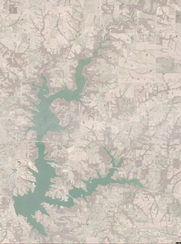
Deleware County, OK
Jun 30, 2026
Fish Why Fish It: The color suggests shallow, sediment-rich water. In 77°F water, this may provide localized nutrients, but fish will likely hug the edges where the tan water meets the darker shadows of the banks.: start with a search bait, then slow down with a contact bait if fish show but miss. Because it has the clearest visible structure/cover combination.
Clay County, MO
Jun 29, 2026
Fish Northern Section.: Cast along the edges of the dock shadows and the transition from the shallow flats to the deeper pockets.. Because A combination of shallow "tan" water (spawning/feeding flats) and dark blue water (deeper pockets) near the dock structures..
Iron, UT
Jun 29, 2026
**IMAGERY FRESHNESS NOTICE:** The capture date (2026-03-20) is over 100 days old. This analysis represents historical pattern context and relative water conditions rather than confirmed current visibility. ### **Main Clarity Read** The data indicates a high-productivity environment with significant biological activity and suspended solids. Expect moderate to low visibility where organic matter and sediment create a "stained" water column. Fish will likely be relying more on lateral line detection and scent than long-range visual tracking. ### **Best Zone** * **Inflow/Shoreline Transition Zones:** Target areas where sediment is concentrated, as the high biological productivity suggests a concentrated food web. * **Deep Channel Bends:** Focus on deeper structural edges where suspended matter settles, providing a balance of cover and forage. ### **Best Clarity Break** * **The Turbidity Edge:** Look for the transition between high-sediment inflow areas and clearer, deeper pockets; fish will hold on these edges to ambush prey moving between different visibility zones. ### **Starting Presentation** * **Vibrating Profiles:** Use medium-sized crankbaits or chatterbaits with a strong rhythmic pulse to cut through the suspended solids. * **Scented Soft Plastics:** Utilize larger-profile worms or craws with added scent to compensate for the reduced visual range. ### **Backup Adjustment** * **Increase Sound/Vibration:** If bites are sluggish, switch to even larger, noisier profiles (like heavy spinnerbaits) and slow your retrieve to allow fish more time to track the target through the stained water.
Cass County, ND
Jun 29, 2026
**IMAGE FRESHNESS NOTICE:** Capture date: 2026-06-14 (15 days old). Imagery is within the 21-day freshness window for current condition analysis. # SATELLITE ANALYSIS REPORT: Brewer Lake, ND ## 1. LAKE OVERVIEW (Natural Sections & Landmarks) Brewer Lake is a relatively small, elongated body of water characterized by a narrow, irregular shape. It appears to be divided into three distinct functional zones: * **Western/Upper Section:** A narrower, winding arm that appears to be fed by a channel or creek entering from the far west. * **Main Lake Body:** The central, widest portion of the lake where the water appears darkest (indicating the deepest continuous section). * **Eastern/Lower Section:** A wider basin that narrows into a structured area on the far east, featuring visible man-made elements. * **Major Landmarks:** A cluster of docks/structures is visible on the eastern shoreline, and a distinct narrow "neck" separates the western arm from the main body. --- ## 2. FINDABLE FISHING SPOTS **1. Western Arm - The Inflow Point** * **General Area:** Western section. * **How to Find It:** Locate the far western tip of the lake where the water narrows significantly into a finger-like channel. * **What You See:** A narrow, winding channel entering from the west. * **Why Fish It:** This area likely provides fresh water inflow and shallower, more protected habitat. * **Best Approach:** Cast along the edges of the narrow channel where the shoreline curves. **2. Central Transition - The "Neck" Structure** * **General Area:** Main lake body (Western edge). * **How to Find It:** From the western arm, head east toward the point where the lake widens significantly into the main body. * **What You See:** A distinct narrowing of the lake (a "neck") before it opens up. * **Why Fish It:** Transition zones between narrow channels and open water often hold fish moving between feeding and refuge areas. * **Best Approach:** Work the edges of the constriction where depth likely changes rapidly. **3. Main Lake - The Deep Center** * **General Area:** Main lake body. * **How to Find It:** The widest, darkest part of the lake, centrally located. * **What You See:** The darkest water color (Dark Blue/Black), indicating the deepest part of the lake. * **Why Fish It:** Provides thermal refuge and access to deeper structure. * **Best Approach:** Target the edges where the dark water meets the lighter shoreline colors (the drop-offs). **4. Eastern Shoreline - The Dock Cluster** * **General Area:** Eastern section. * **How to Find It:** Head to the eastern side of the lake and look for the visible cluster of white/light-colored rectangular shapes (docks/structures) along the shore. * **What You See:** A concentration of docks and man-made shoreline structures. * **Why Fish It:** High cover density; docks provide shade and structural complexity. * **Best Approach:** Slow, methodical casting around the dock pilings and under the shade. **5. Southern Shoreline - The Shallow Bend** * **General
Cass County, ND
Jun 29, 2026
**Note: Imagery is historical (captured 2026-03-20) and should be used as relative pattern context rather than confirmed current conditions.** ### 1. Main Clarity Read The lake shows high biological productivity concentrated in the central and eastern basins, paired with significant suspended sediment throughout the main body. Expect stained to semi-turbid conditions where high organic matter meets sediment, limiting long-range visibility but providing a rich food base. ### 2. Best Zone * **Eastern Basin/Coves:** Target the easternmost reaches where biological activity is highest; the concentration of organic matter suggests a heavy forage base. * **Southern Shoreline Points:** Focus on the southern protrusions where sediment and productivity intersect, creating high-energy feeding windows. ### 3. Best Clarity Break * **Central Basin Transition:** The edge where the high-sediment main body meets the more productive eastern pockets acts as a primary feeding lane for fish moving between cover and forage. ### 4. Starting Presentation * **Moderate Profile/Vibration:** Use medium-sized crankbaits or chatterbaits with a steady retrieve to cut through the suspended sediment. * **Natural Color/Subtle Action:** In the more productive eastern zones, switch to natural-toned soft plastics (weightless or lightly weighted) to mimic the local forage without spooking fish in the stained water. ### 5. Backup Adjustment * **Increase Sound/Thump:** If fish are not committing, move to larger, high-vibration lures (like heavy spinnerbaits or large paddle tails) to help fish locate the presentation in the turbid sections.
Cass County, ND
Jun 29, 2026
**Main Thermal Read** The imagery shows a distinct thermal gradient across the lake, with significantly warmer water concentrated in the northwestern reaches. While the lake-page temperature is 69.0°F, the thermal pattern indicates a strong temperature break between the shallow northwestern inlets and the cooler, more uniform main basin. **Best Water To Start** * **Northwestern Inlets/Coves:** Target the areas showing the highest relative warmth (indicated by the 52°+ thermal signatures). These pockets provide the metabolic boost fish seek during seasonal transitions. * **Central Transition Zone:** Focus on the edge where the warmer northwestern water meets the 55°–56° bands. This thermal boundary often acts as a concentrated feeding lane. **What Fish Are Doing** * **Seeking Warmth:** Predatory fish are likely congregating in the northwestern shallows or near the mouths of northern creeks to take advantage of the higher surface temperatures. * **Edge Following:** Fish are likely patrolling the transition zones between the warmer northern pockets and the cooler central basin, waiting for baitfish to move across the temperature gradient. **On-Water Adjustment** * **If the North is Dead:** Move immediately to the central basin edges where the 55°–56° bands are most stable, focusing on any subtle contour changes or submerged vegetation near those temperature breaks.
Cass County, ND
Jun 29, 2026
Back off to the first break and slow presentations until fish show they will chase
Wasatch County, UT
Jun 29, 2026
**Note: Imagery is historical (captured 2026-03-15). Use these patterns as relative context for seasonal behavior rather than confirmed current conditions.** ### 1. Main Clarity Read The data indicates a high-productivity environment with significant suspended sediment. While biological activity is elevated, the turbidity suggests visibility is likely limited, creating a "stained" water environment where fish will rely heavily on lateral line detection and scent rather than sight. ### 2. Best Zone * **Southern Inflow Channels:** Target the areas where sediment enters the main body; the combination of high nutrients and suspended matter creates a concentrated feeding lane. * **Western Shoreline Points:** Focus on the protruding points along the western edge where structure meets the turbid water, providing cover for fish to ambush prey in lower visibility. ### 3. Best Clarity Break * **The Central Basin Transition:** Look for the edge where the heavy sediment from the southern inflows meets the clearer main body of the reservoir. Fish will hold along this "wall" to utilize the cover of the turbid water while feeding on organisms moving into the clearer zones. ### 4. Starting Presentation * **Moderate Vibration:** Use crankbaits or chatterbaits with a medium-to-large profile to create enough displacement to be detected in the stained water. * **Controlled Retrieve:** Employ a steady, rhythmic retrieve to maintain a consistent "sound footprint" that fish can track through the turbidity. ### 5. Backup Adjustment * **Increase Profile/Sound:** If bites are absent, switch to larger, high-vibration lures (like heavy spinnerbaits or larger soft plastics) and slow your retrieve to allow fish more time to locate the target.
Wasatch County, UT
Jun 29, 2026
**Main Thermal Read** The thermal signature shows a distinct temperature gradient moving from the warmer eastern/northeastern sections toward the cooler western basins. While the lake-page temperature is 61.0°F, the imagery reveals a significant cool-water plume (indicated by the 59°F and lower bands) pushing into the western arms of the reservoir. **Best Water To Start** * **Western Basin Edges:** Target the transition zones where the cooler 59°F water meets the main body. These thermal edges often concentrate baitfish and provide a more comfortable oxygen/temperature window for trout. * **Northeastern Shallow Flats:** Focus on the areas showing warmer 61°F+ signatures near the shoreline. If the bite is slow in the deep, fish may be holding in these slightly warmer, shallower pockets to maintain metabolic activity. **What Fish Are Doing** * **Edge Following:** Fish are likely patrolling the "thermocline" of the surface, moving along the boundary between the 59°F cool water and the 61°F main lake water. * **Thermal Seeking:** Depending on the time of day, fish will be actively seeking the 59°F plumes to avoid the heat of the main lake mass, particularly if the sun is high. **On-Water Adjustment** * **If the edges are dead:** Move toward the deeper, more stable 60°F-61°F water in the center of the main basin, but slow your retrieval to account for lower activity in the warmer water.
Monroe County, NY
Jun 28, 2026
Fish Why Fish It: In a warming-water setup (63.0°F), these shallow, nutrient-rich inflow areas often attract Yellow Perch or baitfish, which in turn draw in larger predators like Chinook or Rainbow trout.: start with a search bait, then slow down with a contact bait if fish show but miss. Because it has the clearest visible structure/cover combination.

Talladega County, AL
Jun 28, 2026
**Main Thermal Read** The imagery shows significant thermal variance across the lake, with localized pockets of warm water reaching up to 85°F. While the lake-page temperature is 78°F, the most critical feature is the sharp temperature gradient between these warm surface plumes and the cooler surrounding water. **Best Water To Start** * **The 74°F–76°F Transition Zones:** Target the edges where the cooler water meets the warmer plumes. These thermal fronts act as natural highways for active predators. * **The 85°F Warm Pockets:** Look for where these high-heat zones intersect with shoreline structure or points. These areas often concentrate baitfish, though they can become too hot if the water is stagnant. **What Fish Are Doing** * **Edge Hunting:** Predatory fish are likely patrolling the temperature breaks, using the cooler water to regulate their body temperature while lunging into the warmer zones to strike bait. * **Thermal Seeking:** Larger fish may be holding in the slightly cooler 74°F–76°F water to avoid the metabolic stress of the 85°F surface spikes, waiting for bait to move through the transition. **On-Water Adjustment** * **If the fronts are dead:** Move away from the high-contrast thermal edges and head toward the more stable, mid-range water (near the 78°F lake-page average) to find fish that have retreated from the extreme temperature swings.

Wayne, MI
Jun 28, 2026
Fish Northernmost visible section.: Casting into the shallowest edges near the shoreline.. Because Light blue/tan color gradients indicating very shallow water (0-6ft) and irregular shoreline..

Saratoga County, NY
Jun 28, 2026
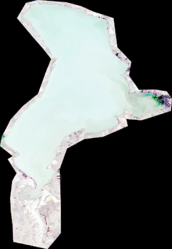
**SATELLITE ANALYSIS REPORT: Saratoga Lake, NY** **Capture Date:** 2026-06-26 (2 days old) **Current Date:** 2026-06-28 **Imagery Status:** Confirmed Current Conditions --- ### 1. LAKE OVERVIEW (Natural Sections & Landmarks) Saratoga Lake presents as a long, irregularly shaped body of water oriented roughly North-to-South. * **Northern Section:** A narrower, more constricted area characterized by winding shorelines and several small inlets. * **Main Lake Body:** The widest and deepest-looking central portion of the lake, showing much darker water (indicating greater depth) compared to the perimeter. * **Southern Section:** A broader area that appears to transition into more complex cove structures and potentially shallower outflow/inflow areas. * **Major Landmarks:** * **The Western Corridor:** A long, relatively straight shoreline on the west side. * **The Eastern Shoreline:** Highly irregular with numerous small points and indentations. * **The "Narrows":** The constricted area in the northern third of the lake. --- ### 2. FINDABLE FISHING SPOTS **1. Northern Section - The Western Shoreline Points** * **How to Find It:** Navigate to the northern third of the lake; look for the small protrusions along the western bank. * **What You See:** Small, irregular points and shallow-looking light blue/tan water hugging the shoreline. * **Why Fish It:** These points provide transition zones from shallow flats to the darker main water. * **Best Approach:** Cast along the edges of these points where the light blue water meets the darker water. * **Priority Rank: 6/10** **2. Main Lake Body - The Central Deep Transition** * **How to Find It:** Locate the widest part of the lake; look for where the water color shifts abruptly from light tan/blue to dark navy/black. * **What You See:** A distinct color gradient indicating a significant drop-off or ledge. * **Why Fish It:** This represents the primary transition zone for larger species (Bass/Pike) moving between shallow feeding areas and deep thermal refuge. * **Best Approach:** Target the "line" where the color changes most sharply. * **Priority Rank: 8/10** **3. Southern Section - The Eastern Cove Complex** * **How to Find It:** Head to the southern half of the lake and look toward the eastern shore for large, indented bays. * **What You See:** Large areas of lighter-colored water (shallow) protected by irregular shoreline geometry. * **Why Fish It:** These protected areas are ideal for Largemouth Bass and Bluegill seeking cover and warmer, stable water. * **Best Approach:** Work the edges of the vegetation (darker irregular patches) within these coves. * **Priority Rank: 7/10** **4. Northern Section - The Eastern Inlets** * **How to Find It:** In the northern narrow section, look for the small "fingers" of water reaching into the eastern shore
Saratoga County, NY
Jun 28, 2026
**Note: Imagery is historical (100 days old) and should be used as a relative pattern context rather than confirmed current conditions.** # CLARITY READ: Saratoga Lake **Main Clarity Read** The historical data indicates a highly productive, stained environment characterized by significant biological activity and suspended solids. Visibility is likely limited, creating a "dirty" to "stained" water profile that favors fish relying on lateral line detection and scent rather than sight. **Best Zone** * **Central Basin/Main Body:** The high concentration of biological productivity and suspended sediment suggests a nutrient-rich zone where fish will congregate to feed on the plankton-driven food chain. * **Inflow/Transition Areas:** Areas where sediment concentrations are highest will serve as primary feeding lanes for fish moving through the water column. **Best Clarity Break** * **Productivity Edges:** The transition between the high-density biological zones and clearer pockets creates a high-probability ambush point where fish can intercept prey moving through the turbidity. **Starting Presentation** * **High-Vibration Profiles:** Use larger, more aggressive profiles (e.g., thick-bodied swimbaits or chatterbaits) to create enough displacement for fish to track in the stained water. * **Slow, Erratic Retrieves:** Implement a slow, methodical retrieve to allow fish time to locate the bait amidst the suspended sediment and biological matter. **Backup Adjustment** * **Increase Sound/Scent:** If fish are not committing, switch to lures with heavy rattling or add scent to compensate for the reduced visual range.

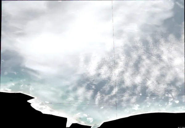
Halifax County, NC
Jun 28, 2026
**IMAGE QUALITY NOTICE:** **Image quality limited - advise caution.** Significant cloud cover obscures large portions of the lake surface, particularly in the central and eastern sections. Depth inference via color gradients is highly unreliable due to cloud reflections and shadows. Analysis is based strictly on visible shoreline geometry and unclouded water segments. --- ### 1. LAKE OVERVIEW (Natural Sections & Landmarks) Lake Gaston presents as a long, winding reservoir characterized by high shoreline complexity. * **Western/Upper Section:** A narrower, more riverine section with winding channels and significant vegetation/tree cover visible along the banks. * **Main Lake Body:** The central, widest portion of the lake where the water body expands significantly. * **Eastern/Lower Section:** A highly fragmented area with numerous finger-like arms and coves. * **Major Landmarks:** While specific names (marinas/dams) are not labeled, the lake is defined by several major "neck" areas where the width narrows significantly, and several large, prominent points that transition the lake from narrow arms to the wide main body. --- ### 2. FINDABLE FISHING SPOTS **Spot 1: Western Section - The Primary River Bend** * **General Area:** Western/Upper section. * **How to Find It:** Locate the narrowest part of the western arm; look for the first major outward bend in the shoreline. * **What You See:** A sharp, curving shoreline with dark green vegetation/trees pressing right to the water's edge. * **Why Fish It:** The bend creates natural current flow and likely holds transition zones between shallow flats and deeper channels. * **Best Approach:** Target the outside of the bend where the water appears slightly darker. **Spot 2: Transition Zone - The Western "Neck" Point** * **General Area:** Transition from Western arm to Main Lake. * **How to Find It:** Follow the western arm eastward until the lake suddenly widens into the main body. Look for the prominent point on the northern side of this widening. * **What You See:** A distinct point of land extending into the widening water. * **Why Fish It:** Points are classic staging areas for Largemouth Bass and Crappie as they move from narrow channels to open water. * **Best Approach:** Work the edge of the point where the shoreline meets the open water. **Spot 3: Main Lake - The Large Northern Peninsula** * **General Area:** Main Lake Body (Northern Shore). * **How to Find It:** In the widest part of the lake, look for the largest protrusion of land on the northern shoreline. * **What You See:** A large, complex peninsula with multiple small indentations/coves. * **Why Fish It:** The complexity of this shoreline provides multiple "micro-habitats" (small coves for Bluegill/Bass and points for larger predators). * **Best Approach:** Cast along the edges of the small coves within this peninsula. **Spot 4: Eastern Arm - The Deep Finger Inflow** * **General Area:** Eastern/Lower Section. * **How to Find It:** Look for the most prominent "finger" of water extending from the main body toward the east/southeast. * **What You See:** A long, narrow arm of water that appears
Halifax County, NC
Jun 28, 2026
Day 1: Moderate wind (9 mph) - prioritize wind-blown points, banks, and bait lanes
Halifax County, NC
Jun 28, 2026
Fish Why Fish It: High-priority for **Largemouth Bass** and **Walleye**. The sharp color change indicates a ledge or drop-off, providing a thermal refuge in 78°F water.: start with a search bait, then slow down with a contact bait if fish show but miss. Because it has the clearest visible structure/cover combination.
Breckinridge County, KY
Jun 28, 2026
**Note: Imagery is historical (100 days old) and should be used for pattern context rather than confirmed current conditions.** **Main Clarity Read** The data indicates a highly productive but turbid environment. High biological activity (MCI) is concentrated in the western and southwestern river arms, while significant suspended sediment (TSS) suggests stained to dirty water conditions throughout the main channels. Expect low visibility that favors fish relying on lateral line detection and scent over sight. **Best Zone** * **Southwestern River Arms/Inflows:** Target the high-productivity pockets where biological activity is concentrated; these areas likely hold the highest concentration of forage. * **Western Shoreline Points:** Focus on the transition zones where sediment meets more stable water to find fish patrolling the edges of the turbidity. **Best Clarity Break** * **The Productivity Edge:** Target the boundary where high-MCI zones meet the clearer main lake water; fish will use these edges to ambush prey moving between nutrient-rich and oxygenated zones. **Starting Presentation** * **Power Fishing:** Use larger-profile lures with significant vibration (e.g., spinnerbaits or chatterbaits) to help fish track the movement through the stained water. * **Slow & Deep:** In the high-productivity western arms, use a slower retrieve with a scent-heavy soft plastic to compensate for the low visibility. **Backup Adjustment** * **Increase Sound/Flash:** If fish are not committing, switch to even larger profiles or lures with aggressive "thumping" components to cut through the suspended sediment.

Clearwater County, MN
Jun 28, 2026
Black crappie: Pre-spawn/spawn temps (65.0°F), target shallow cover with small jigs
Clearwater County, MN
Jun 28, 2026
Black crappie: Pre-spawn/spawn temps (65.0°F), target shallow cover with small jigs
Utah County, UT
Jun 28, 2026
Fish *2. Main Lake Body - The Eastern "Neck" Transition**: start with a search bait, then slow down with a contact bait if fish show but miss. Because it has the clearest visible structure/cover combination.