Big Bear Lake Fishing Report
Synthesis generated comprehensive plan with professional recommendations.
Big Bear Lake Fishing Report
Generated Mar 24, 2026, 10:10 PM.
Key fishing read
- Loud/bright: chartreuse/black, Colorado blades, big profile cranks
- Winter: slow presentations; jigs/spoons; sun-warmed banks/vertical structure
- Estimated phase: winter
- Temp change over window: -17.3°F
- Day 1: High pressure (1014mb) - tougher bite, use finesse tactics
- Day 1: Moderate wind (14mph) - ideal conditions, target windblown points
- Day 1: Clear, High: 72°F, Low: 53°F
- Day 2: High pressure (1014mb) - tougher bite, use finesse tactics
Tool analysis details
Lure Matrix Wind Clarity
Lure guidance for wind=moderate, clarity=unknown, phase=winter.
Findings:
- Loud/bright: chartreuse/black, Colorado blades, big profile cranks
- Winter: slow presentations; jigs/spoons; sun-warmed banks/vertical structure
Estimate Seasonal Phase
Season estimate for Big Bear Lake: winter.
Findings:
- Estimated phase: winter
- Temp change over window: -17.3°F
Analyze Weather Conditions
Weather analysis for Big Bear Lake completed
Findings:
- Day 1: High pressure (1014mb) - tougher bite, use finesse tactics
- Day 1: Moderate wind (14mph) - ideal conditions, target windblown points
- Day 1: Clear, High: 72°F, Low: 53°F
- Day 2: High pressure (1014mb) - tougher bite, use finesse tactics
- Day 2: High winds (23mph) - seek protected areas, use heavier lures
Analyze Solunar Timing
Solunar timing analysis for Big Bear Lake completed
Findings:
- 2026-03-24 Major feeding periods: 05:42 PM - 08:12 PM, 01:26 AM - 03:56 AM
- 2026-03-24 Minor feeding periods: 09:58 AM - 11:28 AM, 12:22 AM - 01:52 AM
- 2026-03-25 Major feeding periods: 06:44 PM - 09:14 PM, 02:30 AM - 05:00 AM
- 2026-03-25 Minor feeding periods: 11:01 AM - 12:31 PM, 01:27 AM - 02:57 AM
- 2026-03-26 Major feeding periods: 07:44 PM - 10:14 PM, 04:30 AM - 07:00 AM
Analyze Species Behavior
Species behavior analysis for Big Bear Lake completed
Findings:
- Largemouth bass: Sluggish in cold water (42.0°F), target deep structure with slow presentations
- Largemouth bass: Spring pre-spawn/spawn mode - target shallow flats and protected coves
- Smallmouth bass: Sluggish in cold water (42.0°F), target deep structure with slow presentations
- Smallmouth bass: Spring pre-spawn/spawn mode - target shallow flats and protected coves
- Rainbow trout: sluggish activity at 42.0°F (optimal: 45-65°F)
Analyze Thermal Patterns
1. Overall Thermal Landscape Summary
- Assumed Orientation: North is at the top of the image.
- Major Visual Anchors:
- The Western Basin: A large, elongated body of water with two distinct, finger-like southern coves.
- The Central Constriction: A narrow section connecting the western basin to the eastern arm.
- The Eastern Inlet: A narrow, tapering channel extending toward the far right (East).
- Dominant Temperatures: The lake is dominated by Medium Blue (46-52°F / 8-11°C), indicating early spring transition conditions.
- Temperature Range: Visible surface temperatures range from approximately 42°F (6°C) in the deepest parts of the western basin to 57°F (14°C) in the far eastern inlet.
2. Detailed Thermal Feature Analysis
Temperature Breaks
- The Eastern Inlet Transition: There is a sharp, distinct thermal break at the entrance to the far eastern inlet. The water shifts from the dominant Medium Blue (46-52°F) to a warmer Cyan/Light Teal (56-60°F / 13-16°C). This is the most significant thermal edge in the entire image.
- Western Cove Edges: The two southern-pointing coves in the western basin show a clear transition at their mouths, where the water warms slightly from the core basin temperature to the Light Blue (52-56°F / 11-13°C) range.
Pockets/Patches
- The Far Eastern Tip: A small, isolated patch of warmer water (Cyan/Light Teal, 56-60°F) is visible at the extreme eastern terminus of the lake.
- Western Basin Core: The deepest, darkest blue area (Dark Blue, 42-46°F) is located in the southwestern portion of the western basin, representing the coldest surface water in the lake.
Gradients
- West-to-East Warming: There is a clear, gradual warming gradient moving from the western basin (coldest) toward the eastern inlet (warmest).
Uniform Areas
- Central Basin: The large, rectangular-shaped central section of the lake exhibits a very uniform Medium Blue (46-52°F) signature, suggesting well-mixed surface water with little thermal variation.
3. Insightful Fish Behavior Interpretation
- General State: The lake is in an "early spring transition." Fish are likely sluggish but beginning to move toward warmer water.
- Movement Patterns: Fish will be actively seeking the warmer "pockets" identified. The transition from the cold central basin to the warmer eastern inlet will act as a migratory corridor.
- Surface Activity: Expect minimal surface feeding in the central basin. The most aggressive feeding behavior will be concentrated in the far eastern inlet where the water reaches the 56-60°F range, as this is the most comfortable thermal zone for fish in this current environment.
4. Satellite Correlation Analysis
- Inflow Identification: The far eastern inlet, which shows the warmest surface temperatures (56-60°F), likely corresponds to a shallow, slow-moving creek mouth or a protected backwater area that absorbs solar radiation more efficiently than the main body of the lake.
- Wind-Mixing: The uniformity of the central basin suggests this area is exposed to prevailing winds, which are preventing the formation of localized warm surface layers.
5. Actionable Fishing Recommendations
- Target the Eastern Inlet: Prioritize the far eastern end of the lake. The thermal break where the water warms to the Cyan/Light Teal range (56-60°F) is your primary target. Focus on the transition zone where the color shifts from Medium Blue to Cyan.
- Cove Mouths: In the western basin, focus on the mouths of the two southern coves. These areas show a slight warming trend (Light Blue, 52-56°F) compared to the main basin and will likely hold fish staging for the spring move.
- Presentation Strategy: Given the overall cool temperatures (46-52°F in the main body), use slow-moving, finesse-style baits. As you move into the warmer eastern inlet, you can increase your retrieve speed to match the more active fish behavior expected in the 56-60°F water.
- Avoid the Core: The dark blue, coldest areas in the southwestern basin should be avoided, as the surface temperatures here (42-46°F) will likely result in very low fish activity levels.
Findings:
- Current surface temperature: 42.0°F. Fish metabolism significantly reduced in cold water. Target sunny, protected shorelines and use extremely slow presentations. Focus on midday when surface temperatures are warmest.
-
1. Overall Thermal Landscape Summary
- Assumed Orientation: North is at the top of the image.
- Major Visual Anchors:
- The Western Basin: A large, elongated body of water with two distinct, finger-like southern coves.
- The Central Constriction: A narrow section connecting the western basin to the eastern arm.
- The Eastern Inlet: A narrow, tapering channel extending toward the far right (East).
- Dominant Temperatures: The lake is dominated by Medium Blue (46-52°F / 8-11°C), indicating early spring transition conditions.
- Temperature Range: Visible surface temperatures range from approximately 42°F (6°C) in the deepest parts of the western basin to 57°F (14°C) in the far eastern inlet.
2. Detailed Thermal Feature Analysis
Temperature Breaks
- The Eastern Inlet Transition: There is a sharp, distinct thermal break at the entrance to the far eastern inlet. The water shifts from the dominant Medium Blue (46-52°F) to a warmer Cyan/Light Teal (56-60°F / 13-16°C). This is the most significant thermal edge in the entire image.
- Western Cove Edges: The two southern-pointing coves in the western basin show a clear transition at their mouths, where the water warms slightly from the core basin temperature to the Light Blue (52-56°F / 11-13°C) range.
Pockets/Patches
- The Far Eastern Tip: A small, isolated patch of warmer water (Cyan/Light Teal, 56-60°F) is visible at the extreme eastern terminus of the lake.
- Western Basin Core: The deepest, darkest blue area (Dark Blue, 42-46°F) is located in the southwestern portion of the western basin, representing the coldest surface water in the lake.
Gradients
- West-to-East Warming: There is a clear, gradual warming gradient moving from the western basin (coldest) toward the eastern inlet (warmest).
Uniform Areas
- Central Basin: The large, rectangular-shaped central section of the lake exhibits a very uniform Medium Blue (46-52°F) signature, suggesting well-mixed surface water with little thermal variation.
3. Insightful Fish Behavior Interpretation
- General State: The lake is in an "early spring transition." Fish are likely sluggish but beginning to move toward warmer water.
- Movement Patterns: Fish will be actively seeking the warmer "pockets" identified. The transition from the cold central basin to the warmer eastern inlet will act as a migratory corridor.
- Surface Activity: Expect minimal surface feeding in the central basin. The most aggressive feeding behavior will be concentrated in the far eastern inlet where the water reaches the 56-60°F range, as this is the most comfortable thermal zone for fish in this current environment.
4. Satellite Correlation Analysis
- Inflow Identification: The far eastern inlet, which shows the warmest surface temperatures (56-60°F), likely corresponds to a shallow, slow-moving creek mouth or a protected backwater area that absorbs solar radiation more efficiently than the main body of the lake.
- Wind-Mixing: The uniformity of the central basin suggests this area is exposed to prevailing winds, which are preventing the formation of localized warm surface layers.
5. Actionable Fishing Recommendations
- Target the Eastern Inlet: Prioritize the far eastern end of the lake. The thermal break where the water warms to the Cyan/Light Teal range (56-60°F) is your primary target. Focus on the transition zone where the color shifts from Medium Blue to Cyan.
- Cove Mouths: In the western basin, focus on the mouths of the two southern coves. These areas show a slight warming trend (Light Blue, 52-56°F) compared to the main basin and will likely hold fish staging for the spring move.
- Presentation Strategy: Given the overall cool temperatures (46-52°F in the main body), use slow-moving, finesse-style baits. As you move into the warmer eastern inlet, you can increase your retrieve speed to match the more active fish behavior expected in the 56-60°F water.
- Avoid the Core: The dark blue, coldest areas in the southwestern basin should be avoided, as the surface temperatures here (42-46°F) will likely result in very low fish activity levels.
- Spring warming: Focus on shallow bays and areas showing the warmest surface temperatures in thermal imagery as fish move into spawning areas.
Analyze Satellite Imagery
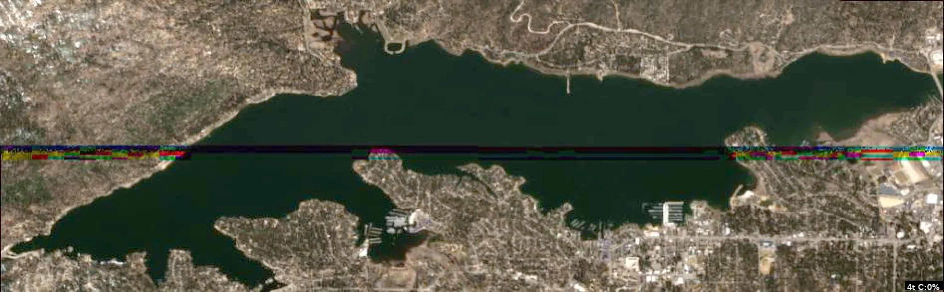
This analysis of Big Bear Lake is based on the provided satellite imagery, focusing on identifiable structure and accessible landmarks for an angler on the water.
1. LAKE OVERVIEW
Big Bear Lake is an elongated, east-to-west oriented reservoir.
- Main Lake Body: The central, deep-water basin stretching between the western dam area and the eastern residential shoreline.
- Western Section: Characterized by the dam structure and steeper, more rugged shorelines.
- Southern Shoreline: Highly developed with multiple marinas, residential docks, and distinct points/coves.
- Northern Shoreline: More uniform with fewer man-made structures, offering longer stretches of natural bank.
- Major Landmarks: The dam (far west), the prominent marinas along the southern shore, and the bridge/causeway area on the far eastern end.
2. FINDABLE FISHING SPOTS
-
Western Dam Area (Main Lake)
- How to Find: Head to the far western end of the lake toward the dam structure.
- What You See: Steep, rocky banks leading into deep water.
- Why Fish It: The dam provides the deepest water in the lake, acting as a thermal refuge during the current 42°F conditions.
- Best Approach: Vertical jigging or slow-moving bottom baits along the steep rock walls.
-
Southern Marina Points (Southern Shore)
- How to Find: Navigate to the central southern shoreline where the major marina complexes are located.
- What You See: A series of points extending into the lake with dense clusters of boat docks.
- Why Fish It: These points offer immediate access to varying depths and provide "cover" (docks) for bass to hold near.
- Best Approach: Target the ends of the docks and the points themselves with jigs or soft plastics.
-
Southwestern Cove (Southern Shore)
- How to Find: West of the main marina cluster, look for the distinct, protected cove.
- What You See: A recessed area with a narrower mouth and shallower water compared to the main lake.
- Why Fish It: Protected from wind and potentially warmer than the main basin; ideal for pre-spawn staging.
- Best Approach: Slow-rolling a spinnerbait or working a jerkbait along the edges of the cove.
-
Northern Shoreline Points (Northern Shore)
- How to Find: Mid-lake, look for the subtle points that break up the long, straight northern shoreline.
- What You See: Minor projections of land that create small, shallow pockets.
- Why Fish It: These points act as "intercept" areas for fish moving between deep water and the shallows.
- Best Approach: Parallel the bank with a crankbait to cover water and find active fish.
-
Eastern Causeway/Bridge Area (Eastern End)
- How to Find: Travel to the far eastern end of the lake near the bridge/causeway.
- What You See: A constricted area where the lake narrows significantly.
- Why Fish It: The "funnel" effect created by the bridge structure concentrates baitfish and predators.
- Best Approach: Focus on the bridge pilings and the transition where the water depth changes near the causeway.
3. VISIBLE FEATURES BY SECTION
- Western Section:
- Dam Face: Steep, deep-water structure.
- Northwest Bank: Rocky, uniform shoreline with minimal cover.
- Main Lake Body:
- Open Water: Deep basin, primary transit zone for trout.
- Southern Points: Prominent land projections that create natural "breaks" in the shoreline.
- Southern Section:
- Marina Clusters: High-density dock structures; excellent for bass holding.
- Coves: Protected, shallower water pockets between points.
- Eastern Section:
- Bridge/Causeway: Man-made structure creating a natural bottleneck.
4. PRACTICAL FISHING GUIDANCE
- Start (Early Morning): Begin in the Southern Marina area. The docks provide immediate cover for bass, and the points allow you to move quickly between shallow and deeper water as the sun rises.
- Mid-Morning/Midday: Move to the Western Dam area. As the water temperature is cold (42°F), fish will likely retreat to the deepest, most stable water available. The dam is the most reliable structure for this.
- Pattern: Think of the lake as a series of "highways." The points are the intersections. In cold water, fish will be on the "deep side" of these intersections. Use the marinas as your primary cover targets and the dam/bridge as your primary structural targets.
- Navigation: The lake is open and easy to navigate. Use the marinas as your primary reference points to orient yourself along the southern shore. When moving from the southern marinas to the dam, stay in the main basin to avoid shallow, rocky hazards near the shoreline.
Findings:
- This analysis of Big Bear Lake is based on the provided satellite imagery, focusing on identifiable structure and accessible landmarks for an angler on the water.
1. LAKE OVERVIEW
Big Bear Lake is an elongated, east-to-west oriented reservoir.
- Main Lake Body: The central, deep-water basin stretching between the western dam area and the eastern residential shoreline.
- Western Section: Characterized by the dam structure and steeper, more rugged shorelines.
- Southern Shoreline: Highly developed with multiple marinas, residential docks, and distinct points/coves.
- Northern Shoreline: More uniform with fewer man-made structures, offering longer stretches of natural bank.
- Major Landmarks: The dam (far west), the prominent marinas along the southern shore, and the bridge/causeway area on the far eastern end.
2. FINDABLE FISHING SPOTS
-
Western Dam Area (Main Lake)
- How to Find: Head to the far western end of the lake toward the dam structure.
- What You See: Steep, rocky banks leading into deep water.
- Why Fish It: The dam provides the deepest water in the lake, acting as a thermal refuge during the current 42°F conditions.
- Best Approach: Vertical jigging or slow-moving bottom baits along the steep rock walls.
-
Southern Marina Points (Southern Shore)
- How to Find: Navigate to the central southern shoreline where the major marina complexes are located.
- What You See: A series of points extending into the lake with dense clusters of boat docks.
- Why Fish It: These points offer immediate access to varying depths and provide "cover" (docks) for bass to hold near.
- Best Approach: Target the ends of the docks and the points themselves with jigs or soft plastics.
-
Southwestern Cove (Southern Shore)
- How to Find: West of the main marina cluster, look for the distinct, protected cove.
- What You See: A recessed area with a narrower mouth and shallower water compared to the main lake.
- Why Fish It: Protected from wind and potentially warmer than the main basin; ideal for pre-spawn staging.
- Best Approach: Slow-rolling a spinnerbait or working a jerkbait along the edges of the cove.
-
Northern Shoreline Points (Northern Shore)
- How to Find: Mid-lake, look for the subtle points that break up the long, straight northern shoreline.
- What You See: Minor projections of land that create small, shallow pockets.
- Why Fish It: These points act as "intercept" areas for fish moving between deep water and the shallows.
- Best Approach: Parallel the bank with a crankbait to cover water and find active fish.
-
Eastern Causeway/Bridge Area (Eastern End)
- How to Find: Travel to the far eastern end of the lake near the bridge/causeway.
- What You See: A constricted area where the lake narrows significantly.
- Why Fish It: The "funnel" effect created by the bridge structure concentrates baitfish and predators.
- Best Approach: Focus on the bridge pilings and the transition where the water depth changes near the causeway.
3. VISIBLE FEATURES BY SECTION
- Western Section:
- Dam Face: Steep, deep-water structure.
- Northwest Bank: Rocky, uniform shoreline with minimal cover.
- Main Lake Body:
- Open Water: Deep basin, primary transit zone for trout.
- Southern Points: Prominent land projections that create natural "breaks" in the shoreline.
- Southern Section:
- Marina Clusters: High-density dock structures; excellent for bass holding.
- Coves: Protected, shallower water pockets between points.
- Eastern Section:
- Bridge/Causeway: Man-made structure creating a natural bottleneck.
4. PRACTICAL FISHING GUIDANCE
- Start (Early Morning): Begin in the Southern Marina area. The docks provide immediate cover for bass, and the points allow you to move quickly between shallow and deeper water as the sun rises.
- Mid-Morning/Midday: Move to the Western Dam area. As the water temperature is cold (42°F), fish will likely retreat to the deepest, most stable water available. The dam is the most reliable structure for this.
- Pattern: Think of the lake as a series of "highways." The points are the intersections. In cold water, fish will be on the "deep side" of these intersections. Use the marinas as your primary cover targets and the dam/bridge as your primary structural targets.
- Navigation: The lake is open and easy to navigate. Use the marinas as your primary reference points to orient yourself along the southern shore. When moving from the southern marinas to the dam, stay in the main basin to avoid shallow, rocky hazards near the shoreline.
Analyze Water Clarity
This analysis is based on the provided satellite imagery for Big Bear Lake, interpreting the combined Chlorophyll and Total Suspended Solids (TSS) indicators.
1. Overall Water Quality Summary
The lake exhibits a highly stable, clear-water profile across the vast majority of its main basin, characterized by deep teal/blue hues (Bottom-Left quadrant of the matrix). This indicates low sediment and low chlorophyll levels, suggesting excellent visibility (15-25+ feet). The primary water quality activity is restricted to the immediate shoreline perimeter, where narrow bands of green and yellow/red indicate localized algae growth and minor sediment suspension, likely due to shallow-water warming and wave action against the banks.
2. Detailed Clarity Zone Mapping & Characterization
- Zone A: The Main Basin (Deep Blue/Teal)
- Matrix Position: Bottom-Left (Low Sediment/Low Chlorophyll).
- Conditions: High visibility (15-25+ feet).
- Tactical Implications: This is the primary "finesse" zone. Fish will be highly sensitive to line diameter and lure profile.
- Zone B: The Immediate Shoreline/Cove Perimeters (Green to Yellow/Red)
- Matrix Position: Bottom-Center to Bottom-Right (Moderate to High Chlorophyll/Low Sediment).
- Conditions: 3-15 feet visibility.
- Tactical Implications: These are the "productive edges." The presence of chlorophyll suggests baitfish activity. Focus on the transition where the teal main basin meets the green shoreline band.
- Zone C: Isolated Shallow Inflows/Docks (Tan/Brown)
- Matrix Position: Top-Left/Top-Center (High Sediment).
- Conditions: 1-6 feet visibility.
- Tactical Implications: High-contrast, vibration-heavy presentations are required here.
3. Turbidity/Algae Sources & Transition Zones
- Sources: The "Red/Yellow" fringes along the shoreline are likely caused by solar heating of shallow water and nutrient runoff from the immediate bank, promoting localized algae growth. The "Tan" areas (visible in the second image) represent localized sediment suspension, likely occurring at boat ramps, marinas, or small creek inlets.
- Transition Zones: The most critical fishing features are the "Clarity Walls"—the sharp color shift from the deep teal of the main basin to the vibrant green/yellow of the shoreline. These edges act as ambush points for predatory fish moving between deep-water sanctuary and shallow-water feeding grounds.
4. Species-Specific Clarity Strategy
- Bass (Largemouth/Smallmouth): Target the Transition Zones (the edge of the teal and green). Use the clear water to locate structure, then cast into the green/yellow fringe to trigger reaction strikes.
- Trout/Sight Feeders: These species will be heavily concentrated in the Main Basin (Zone A). Use long-distance casting and light fluorocarbon line to capitalize on the 15-25ft visibility.
- Panfish/Crappie: Focus on the Yellow/Red shoreline pockets. These areas provide the cover and plankton-rich environment they prefer.
5. Tactical Fishing Adjustments
- Clear Zone (Main Basin): Use natural colors (Green Pumpkin, Watermelon, Clear/Smoke). Employ drop-shot rigs, Ned rigs, or small finesse swimbaits. Maintain maximum distance from the target.
- Transition/Algae Zone (Shoreline): Switch to "reaction" colors (Chartreuse, White, or Bluegill patterns). Chatterbaits and spinnerbaits are ideal here to cut through the slight algae tint and trigger strikes.
- Turbid/Sediment Pockets: Use high-vibration baits (lipless crankbaits with rattles) and dark, high-contrast colors (Black/Blue or bright Chartreuse) to ensure the fish can locate the lure.
6. Seasonal Context
The current imagery shows a lake in a "Clear/Stable" state. The lack of widespread brown (sediment) suggests no recent major storm events or heavy runoff. The presence of thin, localized green/red bands along the shoreline is consistent with early-season warming, where shallow water temperatures rise faster than the main basin, triggering the first stages of biological productivity. The main basin remains highly resilient, maintaining excellent clarity, which is typical for this time of year in high-altitude, deep-water reservoirs.
Findings:
- This analysis is based on the provided satellite imagery for Big Bear Lake, interpreting the combined Chlorophyll and Total Suspended Solids (TSS) indicators.
1. Overall Water Quality Summary
The lake exhibits a highly stable, clear-water profile across the vast majority of its main basin, characterized by deep teal/blue hues (Bottom-Left quadrant of the matrix). This indicates low sediment and low chlorophyll levels, suggesting excellent visibility (15-25+ feet). The primary water quality activity is restricted to the immediate shoreline perimeter, where narrow bands of green and yellow/red indicate localized algae growth and minor sediment suspension, likely due to shallow-water warming and wave action against the banks.
2. Detailed Clarity Zone Mapping & Characterization
- Zone A: The Main Basin (Deep Blue/Teal)
- Matrix Position: Bottom-Left (Low Sediment/Low Chlorophyll).
- Conditions: High visibility (15-25+ feet).
- Tactical Implications: This is the primary "finesse" zone. Fish will be highly sensitive to line diameter and lure profile.
- Zone B: The Immediate Shoreline/Cove Perimeters (Green to Yellow/Red)
- Matrix Position: Bottom-Center to Bottom-Right (Moderate to High Chlorophyll/Low Sediment).
- Conditions: 3-15 feet visibility.
- Tactical Implications: These are the "productive edges." The presence of chlorophyll suggests baitfish activity. Focus on the transition where the teal main basin meets the green shoreline band.
- Zone C: Isolated Shallow Inflows/Docks (Tan/Brown)
- Matrix Position: Top-Left/Top-Center (High Sediment).
- Conditions: 1-6 feet visibility.
- Tactical Implications: High-contrast, vibration-heavy presentations are required here.
3. Turbidity/Algae Sources & Transition Zones
- Sources: The "Red/Yellow" fringes along the shoreline are likely caused by solar heating of shallow water and nutrient runoff from the immediate bank, promoting localized algae growth. The "Tan" areas (visible in the second image) represent localized sediment suspension, likely occurring at boat ramps, marinas, or small creek inlets.
- Transition Zones: The most critical fishing features are the "Clarity Walls"—the sharp color shift from the deep teal of the main basin to the vibrant green/yellow of the shoreline. These edges act as ambush points for predatory fish moving between deep-water sanctuary and shallow-water feeding grounds.
4. Species-Specific Clarity Strategy
- Bass (Largemouth/Smallmouth): Target the Transition Zones (the edge of the teal and green). Use the clear water to locate structure, then cast into the green/yellow fringe to trigger reaction strikes.
- Trout/Sight Feeders: These species will be heavily concentrated in the Main Basin (Zone A). Use long-distance casting and light fluorocarbon line to capitalize on the 15-25ft visibility.
- Panfish/Crappie: Focus on the Yellow/Red shoreline pockets. These areas provide the cover and plankton-rich environment they prefer.
5. Tactical Fishing Adjustments
- Clear Zone (Main Basin): Use natural colors (Green Pumpkin, Watermelon, Clear/Smoke). Employ drop-shot rigs, Ned rigs, or small finesse swimbaits. Maintain maximum distance from the target.
- Transition/Algae Zone (Shoreline): Switch to "reaction" colors (Chartreuse, White, or Bluegill patterns). Chatterbaits and spinnerbaits are ideal here to cut through the slight algae tint and trigger strikes.
- Turbid/Sediment Pockets: Use high-vibration baits (lipless crankbaits with rattles) and dark, high-contrast colors (Black/Blue or bright Chartreuse) to ensure the fish can locate the lure.
6. Seasonal Context
The current imagery shows a lake in a "Clear/Stable" state. The lack of widespread brown (sediment) suggests no recent major storm events or heavy runoff. The presence of thin, localized green/red bands along the shoreline is consistent with early-season warming, where shallow water temperatures rise faster than the main basin, triggering the first stages of biological productivity. The main basin remains highly resilient, maintaining excellent clarity, which is typical for this time of year in high-altitude, deep-water reservoirs.
How this was synthesized
Professional fishing guide analysis integrating 8 tools: lure_matrix_wind_clarity, estimate_seasonal_phase, analyze_weather_conditions, analyze_solunar_timing, analyze_species_behavior, analyze_thermal_patterns, analyze_satellite_imagery, analyze_water_clarity. User request: 'Generate a comprehensive fishing report for Big Bear Lake. Use tools to analyze satellite structure, thermal patterns, water clarity, weather, and solunar timing, then synthesize a concise plan.'. Synthesis generated comprehensive plan with professional recommendations.