Lake Kaweah Fishing Report
Synthesis generated comprehensive plan with professional recommendations.
Lake Kaweah Fishing Report
Generated Mar 6, 2026, 2:03 PM.
Key fishing read
- Day 1: High pressure (1019mb) - tougher bite, use finesse tactics
- Day 1: Moderate wind (12mph) - ideal conditions, target windblown points
- Day 1: MostlyClear, High: 63°F, Low: 45°F
- Day 2: High pressure (1020mb) - tougher bite, use finesse tactics
- Day 2: Moderate wind (13mph) - ideal conditions, target windblown points
- Day 2: MostlyClear, High: 67°F, Low: 44°F
- Day 3: High pressure (1016mb) - tougher bite, use finesse tactics
- Day 3: High winds (18mph) - seek protected areas, use heavier lures
Tool analysis details
Analyze Weather Conditions
Weather analysis for Lake Kaweah completed
Findings:
- Day 1: High pressure (1019mb) - tougher bite, use finesse tactics
- Day 1: Moderate wind (12mph) - ideal conditions, target windblown points
- Day 1: MostlyClear, High: 63°F, Low: 45°F
- Day 2: High pressure (1020mb) - tougher bite, use finesse tactics
- Day 2: Moderate wind (13mph) - ideal conditions, target windblown points
Analyze Pressure Trends
Barometric pressure analysis for Lake Kaweah: falling trend at 1019.00mb
Findings:
- Falling pressure trend detected (1019.00 → lower). Fish will be more active - excellent feeding windows ahead!
- Target shallow areas, use aggressive presentations. Fish are actively feeding.
Analyze Solunar Timing
Solunar timing analysis for Lake Kaweah completed
Findings:
- Plan trips around major solunar periods for peak activity, minor periods offer secondary opportunities
Analyze Thermal Patterns
Overall Thermal Landscape Summary
Assuming North is at the top of the image, East to the right, West to the left, and South at the bottom (standard orientation for satellite imagery). The lake appears as an irregularly shaped body of water, roughly elongated east-west, with a prominent narrow inlet or arm extending westward from the northwest quadrant (near the 60° label), a main central basin, and a distinct eastward-protruding peninsula or point in the northeast quadrant (adjacent to the 62° orange area). Major visual anchors: (1) the narrow northwest inlet/arm capped by the 60° label, (2) the central basin dominated by cyan patches, (3) the northeast peninsula/point with adjacent 62° orange and 62° labels. Dominant colors are cyan/light teal and medium/light blue across most water areas, with isolated orange patches in the northeast. Approximate min/max visible temperatures: 54°F (12°C) to 62°F (17°C), based on labeled values and matching colors (medium blue/light blue for cooler areas ~46-56°F/8-13°C; cyan ~56-60°F/13-16°C; orange anomalously labeled at 62°F/17°C, which falls in light green/yellow-green range per key but appears as orange visually).
Detailed Thermal Feature Analysis
Temperature Breaks
Clearly visible abrupt color transitions from cyan/light teal (56-60°F/13-16°C) to orange (visually 76-78°F/24-26°C but labeled 62°F/17°C) along the eastern edge of the central basin, specifically starting at the base of the northeast peninsula/point (near the right-side 62° label) and extending southward ~1/3 of the peninsula's length. Another sharp break from light blue (52-56°F/11-13°C) to cyan (56-60°F/13-16°C) runs parallel to the southern shoreline of the northwest inlet/arm, just east of the 60° label. These breaks are narrow (linear, <5% of lake width) and jagged, indicating potential surface current or mixing edges.
Pockets/Patches
- Isolated orange patch (76-78°F/24-26°C visually, labeled 62°F/17°C) forming a small, irregular blob (~10% of image area) immediately east of the northeast peninsula/point, bordered by the 62° label.
- Multiple small cyan pockets (56-60°F/13-16°C) scattered in the central basin, one prominent patch south of the northwest inlet/arm (near 59° label) and another in the southeast quadrant adjacent to the eastern shoreline. No very dark navy blue or dark blue (40-46°F/4-8°C) pockets visible; image quality limits distinction of finer sub-50°F areas.
Gradients
Gradual transitions from light blue (52-56°F/11-13°C, e.g., near 54°/55° labels in west-central) to cyan/light teal (56-60°F/13-16°C) across the main central basin, spanning ~20-30% of the lake's north-south extent, oriented roughly east-west. These are smooth, feathered edges rather than sharp, covering the bottom two-thirds of the image between the northwest inlet and northeast peninsula.
Uniform Areas
Large uniform cyan/light teal expanse (56-60°F/13-16°C) dominates the central basin, from just east of the northwest inlet/arm (south of 60° label) to the western base of the northeast peninsula. Smaller uniform light blue zone (52-56°F/11-13°C) along the southwestern shoreline, west of the 55° label cluster. These areas show minimal internal variation, suggesting stable surface mixing.
Insightful Fish Behavior Interpretation
Visible surface temperatures cluster in the 52-62°F (11-17°C) range, aligning with light blue/cyan/light green zones—transitional spring conditions where fish exhibit increasing activity, staging movements, and active surface feeding (per key: pre-spawn to optimal spring temps). Warmer orange patches (anomalously ~62°F/17°C) near the northeast peninsula represent potential comfort/feeding refuges, attracting fish seeking peak activity zones despite modest absolute warmth. Cooler light blue areas (52-56°F/11-13°C) in the west-central may hold sluggish, structure-oriented fish with long feeding windows. Temperature breaks (cyan-to-orange and blue-to-cyan) are prime edges for ambush feeding, as fish often patrol these for baitfish concentrated by surface currents. Focus on surface/shallow behavior: expect dawn/dusk topwater action in warmer patches, jigging transitions at breaks; uniform cyan basin suggests schooling in open water.
Satellite Correlation Analysis
No separate visible satellite imagery (e.g., optical/RGB) provided beyond the thermal layer itself. Thermal patterns align with shoreline geometry: the northwest inlet/arm (60° cap) likely receives inflow mixing cooler surface water (cyan dominance), explaining the blue-to-cyan gradient eastward; northeast peninsula/point funnels warmer surface water into the adjacent orange pocket (possibly wind-protected or shallow flat heating). No clear spring indicators (isolated cold spots) or obvious wind-mixing uniformity beyond central basin. Shoreline transitions show expected land-water jumps (e.g., warmer land oranges ignored), confirming water-focused analysis.
Actionable Fishing Recommendations
- Priority 1: Northeast Peninsula Hotspot—Target the orange patch (62°F/17°C) and its cyan-to-orange break at the base of the northeast peninsula/point (e.g., 50-100yd east of the protrusion's tip). Drift or cast crankbaits/jerkbaits along the sharp linear break for aggressive surface feeders; prime due to relative warmth drawing bait.
- Priority 2: Northwest Inlet Transitions—Fish the light blue-to-cyan gradient parallel to the southern edge of the northwest inlet/arm (east of 60° label, spanning ~1/4 lake width). Slow presentations (suspending jerkbaits, drop-shot) for transitional fish following subtle warming.
- General Tactics: In uniform central cyan basin, troll or fan-cast spinners for roaming schools; avoid deepest uniform blues unless near breaks. Time for low light when surface temps equalize. Use 10-20ft depths near visible breaks for shallow thermocline overlap, but prioritize surface patterns. If windy, focus lee of peninsula for stable warms. Launch nearest southwest shore for quick access to west-central gradients.
Findings:
- Current surface temperature: 50.0°F. Fish showing moderate activity levels. Target temperature transition zones where warmer water meets cooler areas, often near inflows or wind-protected bays.
-
Overall Thermal Landscape Summary
Assuming North is at the top of the image, East to the right, West to the left, and South at the bottom (standard orientation for satellite imagery). The lake appears as an irregularly shaped body of water, roughly elongated east-west, with a prominent narrow inlet or arm extending westward from the northwest quadrant (near the 60° label), a main central basin, and a distinct eastward-protruding peninsula or point in the northeast quadrant (adjacent to the 62° orange area). Major visual anchors: (1) the narrow northwest inlet/arm capped by the 60° label, (2) the central basin dominated by cyan patches, (3) the northeast peninsula/point with adjacent 62° orange and 62° labels. Dominant colors are cyan/light teal and medium/light blue across most water areas, with isolated orange patches in the northeast. Approximate min/max visible temperatures: 54°F (12°C) to 62°F (17°C), based on labeled values and matching colors (medium blue/light blue for cooler areas ~46-56°F/8-13°C; cyan ~56-60°F/13-16°C; orange anomalously labeled at 62°F/17°C, which falls in light green/yellow-green range per key but appears as orange visually).
Detailed Thermal Feature Analysis
Temperature Breaks
Clearly visible abrupt color transitions from cyan/light teal (56-60°F/13-16°C) to orange (visually 76-78°F/24-26°C but labeled 62°F/17°C) along the eastern edge of the central basin, specifically starting at the base of the northeast peninsula/point (near the right-side 62° label) and extending southward ~1/3 of the peninsula's length. Another sharp break from light blue (52-56°F/11-13°C) to cyan (56-60°F/13-16°C) runs parallel to the southern shoreline of the northwest inlet/arm, just east of the 60° label. These breaks are narrow (linear, <5% of lake width) and jagged, indicating potential surface current or mixing edges.
Pockets/Patches
- Isolated orange patch (76-78°F/24-26°C visually, labeled 62°F/17°C) forming a small, irregular blob (~10% of image area) immediately east of the northeast peninsula/point, bordered by the 62° label.
- Multiple small cyan pockets (56-60°F/13-16°C) scattered in the central basin, one prominent patch south of the northwest inlet/arm (near 59° label) and another in the southeast quadrant adjacent to the eastern shoreline. No very dark navy blue or dark blue (40-46°F/4-8°C) pockets visible; image quality limits distinction of finer sub-50°F areas.
Gradients
Gradual transitions from light blue (52-56°F/11-13°C, e.g., near 54°/55° labels in west-central) to cyan/light teal (56-60°F/13-16°C) across the main central basin, spanning ~20-30% of the lake's north-south extent, oriented roughly east-west. These are smooth, feathered edges rather than sharp, covering the bottom two-thirds of the image between the northwest inlet and northeast peninsula.
Uniform Areas
Large uniform cyan/light teal expanse (56-60°F/13-16°C) dominates the central basin, from just east of the northwest inlet/arm (south of 60° label) to the western base of the northeast peninsula. Smaller uniform light blue zone (52-56°F/11-13°C) along the southwestern shoreline, west of the 55° label cluster. These areas show minimal internal variation, suggesting stable surface mixing.
Insightful Fish Behavior Interpretation
Visible surface temperatures cluster in the 52-62°F (11-17°C) range, aligning with light blue/cyan/light green zones—transitional spring conditions where fish exhibit increasing activity, staging movements, and active surface feeding (per key: pre-spawn to optimal spring temps). Warmer orange patches (anomalously ~62°F/17°C) near the northeast peninsula represent potential comfort/feeding refuges, attracting fish seeking peak activity zones despite modest absolute warmth. Cooler light blue areas (52-56°F/11-13°C) in the west-central may hold sluggish, structure-oriented fish with long feeding windows. Temperature breaks (cyan-to-orange and blue-to-cyan) are prime edges for ambush feeding, as fish often patrol these for baitfish concentrated by surface currents. Focus on surface/shallow behavior: expect dawn/dusk topwater action in warmer patches, jigging transitions at breaks; uniform cyan basin suggests schooling in open water.
Satellite Correlation Analysis
No separate visible satellite imagery (e.g., optical/RGB) provided beyond the thermal layer itself. Thermal patterns align with shoreline geometry: the northwest inlet/arm (60° cap) likely receives inflow mixing cooler surface water (cyan dominance), explaining the blue-to-cyan gradient eastward; northeast peninsula/point funnels warmer surface water into the adjacent orange pocket (possibly wind-protected or shallow flat heating). No clear spring indicators (isolated cold spots) or obvious wind-mixing uniformity beyond central basin. Shoreline transitions show expected land-water jumps (e.g., warmer land oranges ignored), confirming water-focused analysis.
Actionable Fishing Recommendations
- Priority 1: Northeast Peninsula Hotspot—Target the orange patch (62°F/17°C) and its cyan-to-orange break at the base of the northeast peninsula/point (e.g., 50-100yd east of the protrusion's tip). Drift or cast crankbaits/jerkbaits along the sharp linear break for aggressive surface feeders; prime due to relative warmth drawing bait.
- Priority 2: Northwest Inlet Transitions—Fish the light blue-to-cyan gradient parallel to the southern edge of the northwest inlet/arm (east of 60° label, spanning ~1/4 lake width). Slow presentations (suspending jerkbaits, drop-shot) for transitional fish following subtle warming.
- General Tactics: In uniform central cyan basin, troll or fan-cast spinners for roaming schools; avoid deepest uniform blues unless near breaks. Time for low light when surface temps equalize. Use 10-20ft depths near visible breaks for shallow thermocline overlap, but prioritize surface patterns. If windy, focus lee of peninsula for stable warms. Launch nearest southwest shore for quick access to west-central gradients.
- Spring warming: Focus on shallow bays and areas showing the warmest surface temperatures in thermal imagery as fish move into spawning areas.
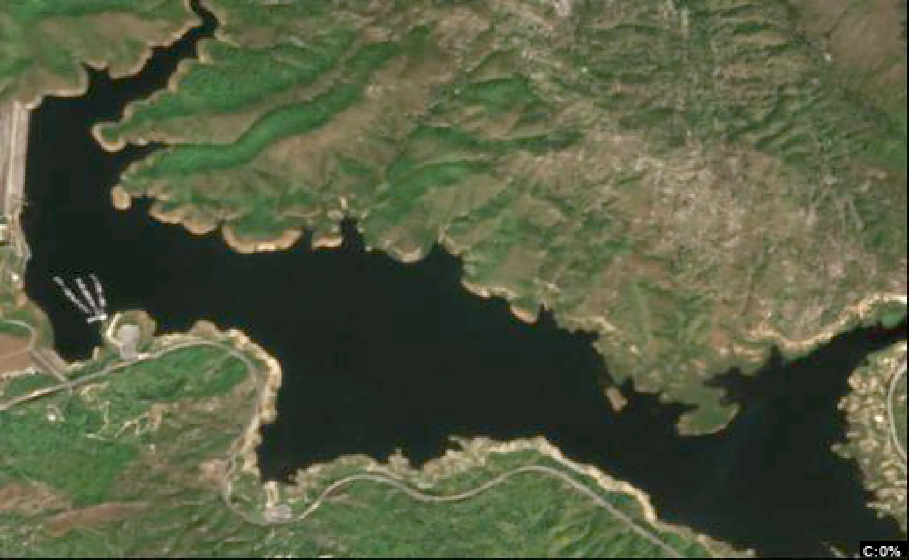
Analyze Satellite Imagery
Lake Kaweah Satellite Analysis - March 06, 2026 (50°F, Pre-Spawn/Spawn Transition)
1. LAKE OVERVIEW (Natural Sections & Landmarks)
Lake Kaweah is an elongated reservoir oriented northwest-southeast, about 8 miles long, with a wide main lake body in the southern two-thirds and narrower upper arms in the north and east.
- Main lake body: Central open water area south of the northern arm junction, widest section with good wind exposure.
- Northern section/arm: Distinct northwest arm narrowing upstream, fed by the North Fork Kaweah River inflow visible as a light sediment fan at the head.
- Eastern section/arm: Northeast arm off the main lake, narrower with South Fork Kaweah inflow visible at the upper end.
- Southern section: Narrowed area near Terminus Dam, with shallower flats visible as lighter colors adjacent to the dam structure.
- Major creek arms: North Fork (northern arm), South Fork (eastern arm); no major western arm.
- Upper lake vs lower lake: Upper lake = northern/eastern arms (narrower, more protected); lower lake = main body south to dam (open, deeper tones).
- Major landmarks: Terminus Dam (southern tip, concrete structure with spillway), Lake Kaweah Marina (west shore of main lake body, cluster of docks and boats), multiple boat ramps (Ramp 1 near marina on west shore, Ramp 2 on east shore of main lake, Ramp 3 at base of northern arm), small islands (two visible in main lake body - one central off east shore, one smaller near southern section), no bridges over water but Highway 189 runs parallel to east shore.
The lake divides naturally at the junction where northern and eastern arms meet the main body (necked-down area with points on both sides).
2. FINDABLE FISHING SPOTS
Here are 6 high-priority, findable spots based on visible structure/cover combos like points with docks, creek mouths, and color transitions (light-to-dark blue indicating drop-offs). Prioritized for pre-spawn bass staging (largemouth/spotted on points/channels) and crappie (brush/docks). Ratings (1-10) factor visible structure complexity, cover, transitions, seasonal fit, and protection.
-
General Area: Northern section/arm
How to Find It: From Ramp 3 at the base of the northern arm, head upstream northwest 0.5 miles to the first major point on the east shore with a cluster of 4-5 docks.
What You See: Point extending into darker water with sharp light-to-medium blue transition; docks along the shore; irregular dark patches near base (possible vegetation).
Why Fish It (Priority 9/10): Point-drop combo perfect for pre-spawn bass staging from deep water; docks add cover for crappie/bluegill; protected from main lake wind.
Best Approach: Cast jigs or soft plastics along the color break from the point; work docks with drop-shot for suspended fish. -
General Area: Main lake body (east shore)
How to Find It: Launch from Ramp 2 on east shore, head south along east shoreline to the large point just north of the central island.
What You See: Prominent point with light blue flats transitioning to dark blue; small cluster of docks mid-point; creek mouth visible as sediment fan upslope.
Why Fish It (Priority 8/10): Creek channel swing into point offers migration route for bass; docks/transition hold crappie; good depth access.
Best Approach: Parallel the drop-off with crankbaits or swimbaits; fan-cast creek mouth for staging largemouth. -
General Area: Main lake body (central)
How to Find It: From Lake Kaweah Marina on west shore, cross main lake east to the small central island, then fish the northeast point of the island.
What You See: Island with points on both sides; northeast point shows color gradient (tan to dark blue); scattered dark spots around base (possible brush).
Why Fish It (Priority 9/10): Offshore point structure with quick depth change ideal for bass refuge; brush-like cover suits crappie; wind-protected lee side.
Best Approach: Circle island with forward-facing sonar if available, or pitch jigs to dark patches; use umbrella rigs over point. -
General Area: Eastern section/arm
How to Find It: From main lake body, enter eastern arm past Ramp 2, go northeast 1 mile to the creek mouth where South Fork enters (visible light fan against darker channel line).
What You See: Serpentine dark line (channel) leading to creek inflow; adjacent points with light-to-dark transitions; sparse docks on south bank.
Why Fish It (Priority 7/10): Channel bend at creek mouth stages pre-spawn bass; protected cove-like area for crappie in cover.
Best Approach: Drag Carolina rigs down channel edge; target creek mouth with lipless baits. -
General Area: Southern section (near dam)
How to Find It: From marina, head south down west shore past the smaller southern island to the cove just north of Terminus Dam.
What You See: Protected cove with multiple docks clustered along west wall; light blue flats with dark linear shadows (laydowns?); sharp color change at cove mouth.
Why Fish It (Priority 8/10): Dock-heavy cove with drop-off at entrance holds bass on cover and crappie under docks; dam current draws forage.
Best Approach: Flip docks with creature baits; suspend under boat houses for crappie. -
General Area: Northern section (west shore)
How to Find It: Launch Ramp 3, hug west shoreline north to the long point opposite the east shore docks (visible across arm).
What You See: Extended point into medium-dark water; cluster of houses/docks at base; color transition along length.
Why Fish It (Priority 7/10): Secondary point with cover for transition-zone bass; arm protection aids early bite.
Best Approach: Run spinnerbaits over point; finesse docks if wind calms.
3. VISIBLE FEATURES BY LAKE SECTION
Northern section/arm: Ramp 3 at south base; east shore cluster of docks on first major point; west shore long point with houses; North Fork creek mouth (sediment fan) at head; scattered dark patches in shallows.
Main lake body: Lake Kaweah Marina (west shore dock cluster); Ramp 1 near marina, Ramp 2 on east; central island (points both sides) and smaller southern island; east shore creek mouth north of Ramp 2; large east shore point with docks; open dark blue center.
Eastern section/arm: South Fork creek mouth at upper end (sediment fan/channel line); sparse docks on south bank; narrowing points with color changes.
Southern section: Terminus Dam (south end); dock-filled cove north of dam on west; light flats east of dam; smaller island offshore.
4. PRACTICAL FISHING GUIDANCE
Suggested fishing progression (pre-spawn at 50°F: bass moving shallow, crappie on cover):
- Start (early morning): Northern section - Ramp 3 point with docks (protected shallows for active fish).
- Mid-morning: Move to main lake body - central island point (as sun rises, fish to offshore structure).
- Pattern: Northern arm shallows early → main lake points midday → eastern arm channels afternoon (follow migration upslope). End at southern docks if wind picks up.
Navigation between sections:
- Northern to main lake: Straight south from Ramp 3 through arm junction (pass east shore docks).
- Main lake to eastern arm: East from Ramp 2, skirt central island.
- Main lake to southern: South from marina, stay west shore past small island to dam cove.
- Full loop: Clockwise - marina → south → east arm → north arm → back via main body (2-3 hours transit).
Focus on color transitions and docks - mark them on your GPS from launch for repeats. Tight lines!
Findings:
-
Lake Kaweah Satellite Analysis - March 06, 2026 (50°F, Pre-Spawn/Spawn Transition)
1. LAKE OVERVIEW (Natural Sections & Landmarks)
Lake Kaweah is an elongated reservoir oriented northwest-southeast, about 8 miles long, with a wide main lake body in the southern two-thirds and narrower upper arms in the north and east.
- Main lake body: Central open water area south of the northern arm junction, widest section with good wind exposure.
- Northern section/arm: Distinct northwest arm narrowing upstream, fed by the North Fork Kaweah River inflow visible as a light sediment fan at the head.
- Eastern section/arm: Northeast arm off the main lake, narrower with South Fork Kaweah inflow visible at the upper end.
- Southern section: Narrowed area near Terminus Dam, with shallower flats visible as lighter colors adjacent to the dam structure.
- Major creek arms: North Fork (northern arm), South Fork (eastern arm); no major western arm.
- Upper lake vs lower lake: Upper lake = northern/eastern arms (narrower, more protected); lower lake = main body south to dam (open, deeper tones).
- Major landmarks: Terminus Dam (southern tip, concrete structure with spillway), Lake Kaweah Marina (west shore of main lake body, cluster of docks and boats), multiple boat ramps (Ramp 1 near marina on west shore, Ramp 2 on east shore of main lake, Ramp 3 at base of northern arm), small islands (two visible in main lake body - one central off east shore, one smaller near southern section), no bridges over water but Highway 189 runs parallel to east shore.
The lake divides naturally at the junction where northern and eastern arms meet the main body (necked-down area with points on both sides).
2. FINDABLE FISHING SPOTS
Here are 6 high-priority, findable spots based on visible structure/cover combos like points with docks, creek mouths, and color transitions (light-to-dark blue indicating drop-offs). Prioritized for pre-spawn bass staging (largemouth/spotted on points/channels) and crappie (brush/docks). Ratings (1-10) factor visible structure complexity, cover, transitions, seasonal fit, and protection.
-
General Area: Northern section/arm
How to Find It: From Ramp 3 at the base of the northern arm, head upstream northwest 0.5 miles to the first major point on the east shore with a cluster of 4-5 docks.
What You See: Point extending into darker water with sharp light-to-medium blue transition; docks along the shore; irregular dark patches near base (possible vegetation).
Why Fish It (Priority 9/10): Point-drop combo perfect for pre-spawn bass staging from deep water; docks add cover for crappie/bluegill; protected from main lake wind.
Best Approach: Cast jigs or soft plastics along the color break from the point; work docks with drop-shot for suspended fish. -
General Area: Main lake body (east shore)
How to Find It: Launch from Ramp 2 on east shore, head south along east shoreline to the large point just north of the central island.
What You See: Prominent point with light blue flats transitioning to dark blue; small cluster of docks mid-point; creek mouth visible as sediment fan upslope.
Why Fish It (Priority 8/10): Creek channel swing into point offers migration route for bass; docks/transition hold crappie; good depth access.
Best Approach: Parallel the drop-off with crankbaits or swimbaits; fan-cast creek mouth for staging largemouth. -
General Area: Main lake body (central)
How to Find It: From Lake Kaweah Marina on west shore, cross main lake east to the small central island, then fish the northeast point of the island.
What You See: Island with points on both sides; northeast point shows color gradient (tan to dark blue); scattered dark spots around base (possible brush).
Why Fish It (Priority 9/10): Offshore point structure with quick depth change ideal for bass refuge; brush-like cover suits crappie; wind-protected lee side.
Best Approach: Circle island with forward-facing sonar if available, or pitch jigs to dark patches; use umbrella rigs over point. -
General Area: Eastern section/arm
How to Find It: From main lake body, enter eastern arm past Ramp 2, go northeast 1 mile to the creek mouth where South Fork enters (visible light fan against darker channel line).
What You See: Serpentine dark line (channel) leading to creek inflow; adjacent points with light-to-dark transitions; sparse docks on south bank.
Why Fish It (Priority 7/10): Channel bend at creek mouth stages pre-spawn bass; protected cove-like area for crappie in cover.
Best Approach: Drag Carolina rigs down channel edge; target creek mouth with lipless baits. -
General Area: Southern section (near dam)
How to Find It: From marina, head south down west shore past the smaller southern island to the cove just north of Terminus Dam.
What You See: Protected cove with multiple docks clustered along west wall; light blue flats with dark linear shadows (laydowns?); sharp color change at cove mouth.
Why Fish It (Priority 8/10): Dock-heavy cove with drop-off at entrance holds bass on cover and crappie under docks; dam current draws forage.
Best Approach: Flip docks with creature baits; suspend under boat houses for crappie. -
General Area: Northern section (west shore)
How to Find It: Launch Ramp 3, hug west shoreline north to the long point opposite the east shore docks (visible across arm).
What You See: Extended point into medium-dark water; cluster of houses/docks at base; color transition along length.
Why Fish It (Priority 7/10): Secondary point with cover for transition-zone bass; arm protection aids early bite.
Best Approach: Run spinnerbaits over point; finesse docks if wind calms.
3. VISIBLE FEATURES BY LAKE SECTION
Northern section/arm: Ramp 3 at south base; east shore cluster of docks on first major point; west shore long point with houses; North Fork creek mouth (sediment fan) at head; scattered dark patches in shallows.
Main lake body: Lake Kaweah Marina (west shore dock cluster); Ramp 1 near marina, Ramp 2 on east; central island (points both sides) and smaller southern island; east shore creek mouth north of Ramp 2; large east shore point with docks; open dark blue center.
Eastern section/arm: South Fork creek mouth at upper end (sediment fan/channel line); sparse docks on south bank; narrowing points with color changes.
Southern section: Terminus Dam (south end); dock-filled cove north of dam on west; light flats east of dam; smaller island offshore.
4. PRACTICAL FISHING GUIDANCE
Suggested fishing progression (pre-spawn at 50°F: bass moving shallow, crappie on cover):
- Start (early morning): Northern section - Ramp 3 point with docks (protected shallows for active fish).
- Mid-morning: Move to main lake body - central island point (as sun rises, fish to offshore structure).
- Pattern: Northern arm shallows early → main lake points midday → eastern arm channels afternoon (follow migration upslope). End at southern docks if wind picks up.
Navigation between sections:
- Northern to main lake: Straight south from Ramp 3 through arm junction (pass east shore docks).
- Main lake to eastern arm: East from Ramp 2, skirt central island.
- Main lake to southern: South from marina, stay west shore past small island to dam cove.
- Full loop: Clockwise - marina → south → east arm → north arm → back via main body (2-3 hours transit).
Focus on color transitions and docks - mark them on your GPS from launch for repeats. Tight lines!
Analyze Water Clarity
1. Overall Water Quality Summary
The provided clarity images depict Lake Kaweah with contrasting conditions across the two visuals. The first image is dominated by dark blue/teal colors throughout the main lake body, arms, and coves, aligning with the bottom-left quadrant (low sediment + low chlorophyll) for exceptionally clear water. The second image shows uniform brown/tan coloration across the entire lake outline, corresponding to the top-left quadrant (high sediment + low chlorophyll) indicating widespread muddy conditions. Cross-image correlation reveals a unified pattern of low chlorophyll levels (consistent blues/teals in image 1) overlaid with high sediment loading (brown/tan in image 2), resulting in predominantly top-left matrix conditions: muddy water with 2-6 feet visibility, minimal algae influence, and potential recent sediment influx affecting the otherwise clear base.
2. Detailed Clarity Zone Mapping & Characterization (3-5 Key Zones with locations, categories, causes)
STEP-BY-STEP MATRIX ANALYSIS (Cross-Image):
- Color Identification: Image 1: Dark blue/teal dominant, with minor lighter blue patches near center; Image 2: Uniform brown/tan across all areas.
- Matrix Translation: Dark blue/teal (image 1) = bottom-left (low sed + low chlor); brown/tan (image 2) = top-left (high sed + low chlor). Combined: Shift to top-left dominance due to sediment overlay on low-chlorophyll base.
- Location Mapping: Compass-based using lake shape (north-up orientation: prominent NW arm protruding upward-left, main basin center, SE flat extending rightward).
- Visibility Assessment: 2-6 feet across zones due to sediment dominance.
-
Zone 1: NW Arm (northern protruding arm from central basin)
Matrix Position: Dark blue/teal (image 1, bottom-left) + brown/tan overlay (image 2, top-left).
Combined Conditions: High sediment + low chlorophyll = muddy runoff water, 2-6 ft visibility.
Tactical Implications: Vibration-heavy tactics needed despite low algae.
Transition: Gradual edge at arm's southern join to main basin. -
Zone 2: Central Main Basin (core lake body, mid-image)
Matrix Position: Uniform dark blue/teal (image 1, bottom-left) + full brown/tan (image 2, top-left), minor lighter blue patch center-east.
Combined Conditions: High sediment + low chlorophyll = uniform muddy conditions, 3-5 ft visibility.
Tactical Implications: Power fishing viable in open water.
Transition: Subtle central patch edge where lighter blue meets darker. -
Zone 3: SE Flats/Shoreline (southeastern extension, bottom-right lake edge)
Matrix Position: Dark blue/teal near shore (image 1, bottom-left) + dense brown/tan (image 2, top-left).
Combined Conditions: High sediment + low chlorophyll = wind-stirred shallows, 2-4 ft visibility.
Tactical Implications: Target shallow structure with noise.
Transition: Sharp boundary at western edge joining main basin. -
Zone 4: Western Shoreline Cove (left-side irregular indentation)
Matrix Position: Dark blue/teal (image 1, bottom-left) + brown/tan (image 2, top-left).
Combined Conditions: High sediment + low chlorophyll = protected muddy pocket, 2-6 ft visibility.
Tactical Implications: Finesse edges due to potential cover.
3. Turbidity/Algae Sources & Transition Zones Analysis
Source Identification (Visual): Brown/tan dominance in image 2 points to high sediment sources along all shorelines, particularly the irregular NW arm and western coves (likely wind-blown banks or shallow stirring) and SE flats (potential runoff points). Dark blue/teal in image 1 confirms negligible algae (no greens/yellows/reds visible), with low chlorophyll statewide—no protected cove blooms or nutrient inflows evident.
Clarity Breaks/Edges:
- Gradual turbidity wall along NW arm's southern base (brown/tan meets residual teal undertones), running NE-SW ~1/3 lake width—high productivity as bait may congregate here.
- Sharp mudline at SE flats' western boundary (dense tan abutting main basin blue), ideal ambush point.
- Subtle central basin patch (lighter blue in image 1 amid brown overlay)—minor edge for reaction bites. These transitions signify sediment plumes creating "walls" where clearer base water (image 1) interfaces turbid surface (image 2), concentrating fish as forage escapes into muddier zones.
4. Species-Specific Clarity Strategy (Recommendations tied to zones)
Bass likely favor muddy top-left conditions (2-6 ft vis), patrolling transition edges: target NW arm join (Zone 1) and SE flats boundary (Zone 3) for ambush from structure into sediment plumes. Walleye/Crappie may suspend in slightly deeper central basin (Zone 2), using low light penetration in brown overlay for mid-water feeding—probe subtle central patch edges. Catfish hold tight to bottom in western cove (Zone 4), drawn to stirred sediment. Sight-feeders absent due to no bottom-left purity; prioritize bass/catfish in all zones, casting to NW-SE transitions where mudlines offer cover contrast.
5. Tactical Fishing Adjustments (Lures/Presentations tied to zones)
General (Cold 50°F + Muddy Top-Left): Downsize baits 25%, slow retrieves; braided 15-20lb for muddy water, moderate casts (20-30 yards), standard boat positioning.
- Zone 1 (NW Arm): High-contrast colors (black/blue, chartreuse/orange) for low-chlor muddy vis; 1/2 oz spinnerbaits or lipless crankbaits with rattles. Slow-steady retrieve along southern transition—parallel mudline for reaction strikes.
- Zone 2 (Central Basin): Bright chartreuse/white big worms or chatterbaits; maximum vibration to cut sediment. Yo-yo retrieve over open water, focus central patch edge for suspended fish.
- Zone 3 (SE Flats): Orange/black lipless or large profile spinnerbaits; noise critical. Fan-cast western mudline break, short pitches (10-20 yards) into shallows.
- Zone 4 (Western Cove): Black/blue jigs or big worms; vibration + scent. Drag slowly along shoreline drop, long casts to avoid spooking in pocket.
Clarity Breaks: Fish edges with mixed retrieves—fast rip-jerk into mudline for bass reaction, then pause in clearer side; alternate power (rattles) and finesse (slow drag) at NW-SE walls.
Line/Cast/Position: Muddy protocol across zones: braid 15-20lb, 20-30 yard casts to transitions, position 30+ yards off breaks.
6. Seasonal Context (Interpretation of visual patterns)
The uniform brown/tan sediment blanket (image 2) over clear blue base (image 1) suggests recent heavy turbidity event like wind-stirring shallows or inflow pulses, creating atypical widespread muddiness despite low algae resilience in the main basin's teal undertones. No algae blooms (absent yellows/reds/greens) indicate cooler/dormant plankton, consistent with cold fronts limiting productivity; central basin's persistent dark blue amid overlay shows core clarity resilience, prime for deep sluggish fish. Patterns appear post-disturbance rather than chronic, with transitions signaling recovery edges.
Findings:
-
1. Overall Water Quality Summary
The provided clarity images depict Lake Kaweah with contrasting conditions across the two visuals. The first image is dominated by dark blue/teal colors throughout the main lake body, arms, and coves, aligning with the bottom-left quadrant (low sediment + low chlorophyll) for exceptionally clear water. The second image shows uniform brown/tan coloration across the entire lake outline, corresponding to the top-left quadrant (high sediment + low chlorophyll) indicating widespread muddy conditions. Cross-image correlation reveals a unified pattern of low chlorophyll levels (consistent blues/teals in image 1) overlaid with high sediment loading (brown/tan in image 2), resulting in predominantly top-left matrix conditions: muddy water with 2-6 feet visibility, minimal algae influence, and potential recent sediment influx affecting the otherwise clear base.
2. Detailed Clarity Zone Mapping & Characterization (3-5 Key Zones with locations, categories, causes)
STEP-BY-STEP MATRIX ANALYSIS (Cross-Image):
- Color Identification: Image 1: Dark blue/teal dominant, with minor lighter blue patches near center; Image 2: Uniform brown/tan across all areas.
- Matrix Translation: Dark blue/teal (image 1) = bottom-left (low sed + low chlor); brown/tan (image 2) = top-left (high sed + low chlor). Combined: Shift to top-left dominance due to sediment overlay on low-chlorophyll base.
- Location Mapping: Compass-based using lake shape (north-up orientation: prominent NW arm protruding upward-left, main basin center, SE flat extending rightward).
- Visibility Assessment: 2-6 feet across zones due to sediment dominance.
-
Zone 1: NW Arm (northern protruding arm from central basin)
Matrix Position: Dark blue/teal (image 1, bottom-left) + brown/tan overlay (image 2, top-left).
Combined Conditions: High sediment + low chlorophyll = muddy runoff water, 2-6 ft visibility.
Tactical Implications: Vibration-heavy tactics needed despite low algae.
Transition: Gradual edge at arm's southern join to main basin. -
Zone 2: Central Main Basin (core lake body, mid-image)
Matrix Position: Uniform dark blue/teal (image 1, bottom-left) + full brown/tan (image 2, top-left), minor lighter blue patch center-east.
Combined Conditions: High sediment + low chlorophyll = uniform muddy conditions, 3-5 ft visibility.
Tactical Implications: Power fishing viable in open water.
Transition: Subtle central patch edge where lighter blue meets darker. -
Zone 3: SE Flats/Shoreline (southeastern extension, bottom-right lake edge)
Matrix Position: Dark blue/teal near shore (image 1, bottom-left) + dense brown/tan (image 2, top-left).
Combined Conditions: High sediment + low chlorophyll = wind-stirred shallows, 2-4 ft visibility.
Tactical Implications: Target shallow structure with noise.
Transition: Sharp boundary at western edge joining main basin. -
Zone 4: Western Shoreline Cove (left-side irregular indentation)
Matrix Position: Dark blue/teal (image 1, bottom-left) + brown/tan (image 2, top-left).
Combined Conditions: High sediment + low chlorophyll = protected muddy pocket, 2-6 ft visibility.
Tactical Implications: Finesse edges due to potential cover.
3. Turbidity/Algae Sources & Transition Zones Analysis
Source Identification (Visual): Brown/tan dominance in image 2 points to high sediment sources along all shorelines, particularly the irregular NW arm and western coves (likely wind-blown banks or shallow stirring) and SE flats (potential runoff points). Dark blue/teal in image 1 confirms negligible algae (no greens/yellows/reds visible), with low chlorophyll statewide—no protected cove blooms or nutrient inflows evident.
Clarity Breaks/Edges:
- Gradual turbidity wall along NW arm's southern base (brown/tan meets residual teal undertones), running NE-SW ~1/3 lake width—high productivity as bait may congregate here.
- Sharp mudline at SE flats' western boundary (dense tan abutting main basin blue), ideal ambush point.
- Subtle central basin patch (lighter blue in image 1 amid brown overlay)—minor edge for reaction bites. These transitions signify sediment plumes creating "walls" where clearer base water (image 1) interfaces turbid surface (image 2), concentrating fish as forage escapes into muddier zones.
4. Species-Specific Clarity Strategy (Recommendations tied to zones)
Bass likely favor muddy top-left conditions (2-6 ft vis), patrolling transition edges: target NW arm join (Zone 1) and SE flats boundary (Zone 3) for ambush from structure into sediment plumes. Walleye/Crappie may suspend in slightly deeper central basin (Zone 2), using low light penetration in brown overlay for mid-water feeding—probe subtle central patch edges. Catfish hold tight to bottom in western cove (Zone 4), drawn to stirred sediment. Sight-feeders absent due to no bottom-left purity; prioritize bass/catfish in all zones, casting to NW-SE transitions where mudlines offer cover contrast.
5. Tactical Fishing Adjustments (Lures/Presentations tied to zones)
General (Cold 50°F + Muddy Top-Left): Downsize baits 25%, slow retrieves; braided 15-20lb for muddy water, moderate casts (20-30 yards), standard boat positioning.
- Zone 1 (NW Arm): High-contrast colors (black/blue, chartreuse/orange) for low-chlor muddy vis; 1/2 oz spinnerbaits or lipless crankbaits with rattles. Slow-steady retrieve along southern transition—parallel mudline for reaction strikes.
- Zone 2 (Central Basin): Bright chartreuse/white big worms or chatterbaits; maximum vibration to cut sediment. Yo-yo retrieve over open water, focus central patch edge for suspended fish.
- Zone 3 (SE Flats): Orange/black lipless or large profile spinnerbaits; noise critical. Fan-cast western mudline break, short pitches (10-20 yards) into shallows.
- Zone 4 (Western Cove): Black/blue jigs or big worms; vibration + scent. Drag slowly along shoreline drop, long casts to avoid spooking in pocket.
Clarity Breaks: Fish edges with mixed retrieves—fast rip-jerk into mudline for bass reaction, then pause in clearer side; alternate power (rattles) and finesse (slow drag) at NW-SE walls.
Line/Cast/Position: Muddy protocol across zones: braid 15-20lb, 20-30 yard casts to transitions, position 30+ yards off breaks.
6. Seasonal Context (Interpretation of visual patterns)
The uniform brown/tan sediment blanket (image 2) over clear blue base (image 1) suggests recent heavy turbidity event like wind-stirring shallows or inflow pulses, creating atypical widespread muddiness despite low algae resilience in the main basin's teal undertones. No algae blooms (absent yellows/reds/greens) indicate cooler/dormant plankton, consistent with cold fronts limiting productivity; central basin's persistent dark blue amid overlay shows core clarity resilience, prime for deep sluggish fish. Patterns appear post-disturbance rather than chronic, with transitions signaling recovery edges.
How this was synthesized
Professional fishing guide analysis integrating 6 tools: analyze_weather_conditions, analyze_pressure_trends, analyze_solunar_timing, analyze_thermal_patterns, analyze_satellite_imagery, analyze_water_clarity. User request: 'Analyze the water clarity for Lake Kaweah. Identify clear vs. murky areas and suggest fishing strategies based on clarity conditions.'. Synthesis generated comprehensive plan with professional recommendations.