DeWeese Reservoir Fishing Report
Synthesis generated comprehensive plan with professional recommendations.
DeWeese Reservoir Fishing Report
Generated Dec 13, 2025, 3:15 PM.
Key fishing read
-
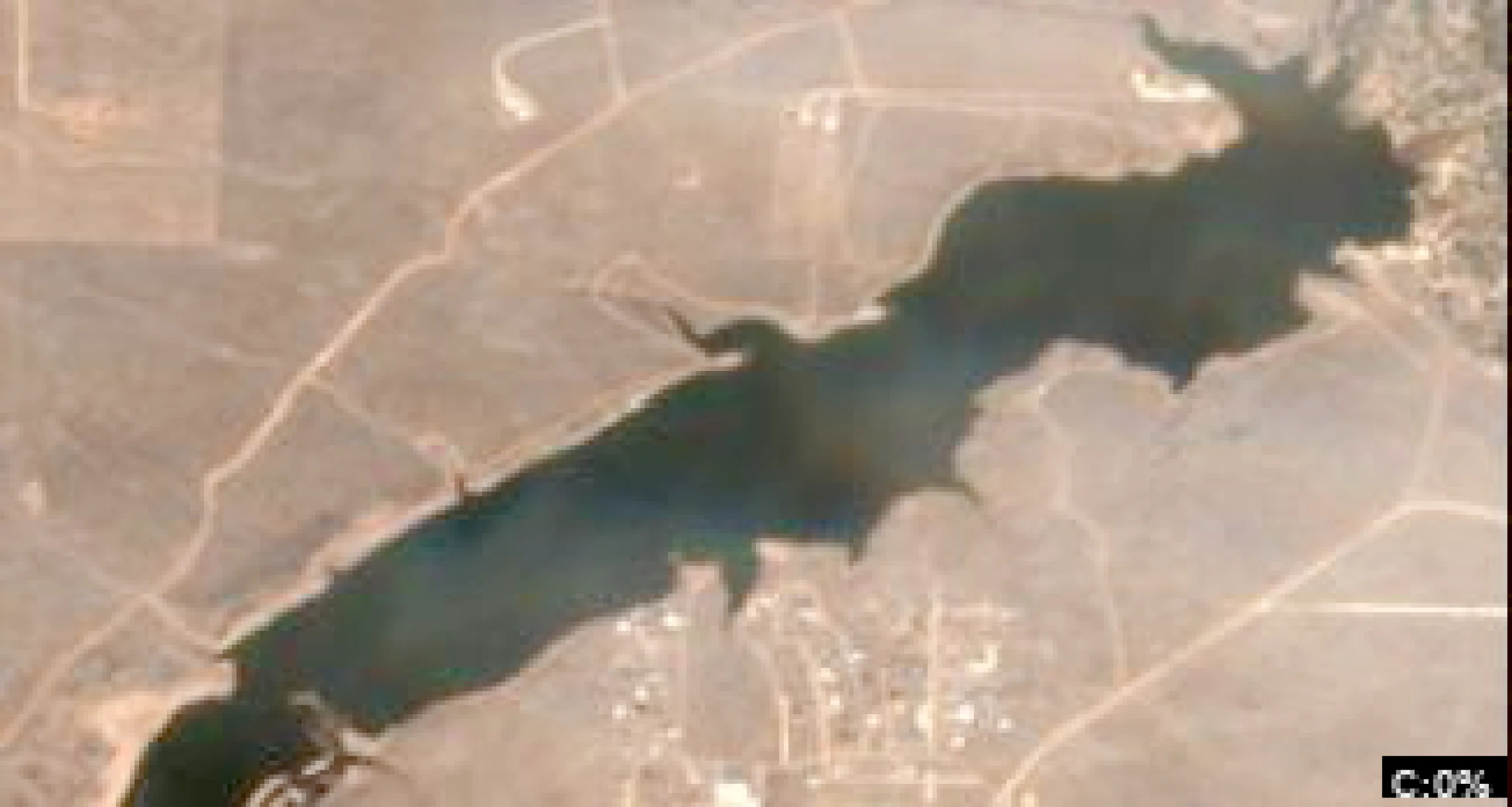
DeWeese Reservoir Satellite Analysis (December 13, 2025)
1. LAKE OVERVIEW (Natural Sections & Landmarks)
DeWeese Reservoir is a compact, irregularly shaped body of water nestled in steep, snow-covered mountains, oriented roughly north-south with a total length under 1 mile. The lake divides naturally into three sections:
- Main lake body: Central open dark water area (dark blue/black tones indicating deeper water), widest in the middle with irregular shorelines.
- Northern section/arm: Narrower, elongated inlet-like arm extending north, with jagged shorelines and a serpentine dark line suggesting a creek channel.
- Southern section: Wider basin at the south end, bounded by a straight light line (likely the dam) and steeper terrain.
Major landmarks visible:
- Straight horizontal light line at the southern tip (dam structure).
- Cleared tan patch near the southern shore (possible boat ramp or access area adjacent to the dam).
- No islands, bridges, or marinas clearly visible; shoreline dominated by natural rocky/snowy points and narrow coves. The lake narrows slightly in the central area, creating a natural "neck" between northern arm and southern basin, with all sections accessible by hugging the shoreline.
2. FINDABLE FISHING SPOTS
Identified 6 high-priority spots based on visible shoreline points, color transitions (tan/light blue to dark blue), creek-like dark lines, and winter trout patterns (deep refuge near structure). Prioritized for steep banks, channel bends, and drop-offs (sharp color changes).
-
General Area: Southern section
How to Find It: Launch from the tan cleared area near the dam, then head north along the west shore to the first major point jutting into the dark water.
What You See: Prominent shoreline point with sharp tan-to-dark color transition; adjacent steep snowy bank.
Why Fish It: Point extends into deeper dark water—ideal winter trout refuge with drop-off for ambush (Priority: 8/10 for structure + depth access).
Best Approach: Drift or anchor off the point tip, jig vertically in dark water zone. -
General Area: Main lake body
How to Find It: From southern dam area, go north through the central neck to the large east-shore point (biggest protrusion into main open water).
What You See: Bold shoreline point with light tan flat transitioning to surrounding dark blue; nearby irregular dark patch on shore.
Why Fish It: Classic deep point with adjacent shallow flat—trout stage here pre-spawn (Priority: 9/10 for transition + seasonal fit).
Best Approach: Troll or cast along the color break from boat, targeting the point's outer edge. -
General Area: Northern section/arm
How to Find It: Enter northern arm from main body (pass the central neck), follow the west shore to where the serpentine dark creek line meets the lake.
What You See: Dark serpentine inlet/channel pouring into tan shallows, flanked by steep points.
Why Fish It: Creek mouth channel bend holds winter trout migrating from deep main lake (Priority: 8/10 for inflow + cover).
Best Approach: Position in channel mouth, suspend baits near bottom in darker water. -
General Area: Main lake body
How to Find It: From east-shore point (spot #2), cross to opposite west shore—target the recessed cove with double points framing it.
What You See: Small protected cove with two short points and internal color gradient (light interior to dark outer).
Why Fish It: Wind-protected with ledge-like transitions—trout use as thermal break (Priority: 7/10 for protection + complexity).
Best Approach: Back boat into cove, fan-cast points and transitions. -
General Area: Southern section
How to Find It: Near dam launch area, hug east shore south to the narrow cove-like indentation before the dam wall.
What You See: Tight cove with dark water pocket against light dam line; steep bank drop.
Why Fish It: Deep pocket near dam structure—stable winter depths for schooling trout (Priority: 7/10 for refuge + accessibility).
Best Approach: Anchor close to dam face, vertical jig in black water. -
General Area: Northern section/arm
How to Find It: Deep in northern arm, find the mid-arm point on the east side (sharp jut amid snowy terrain).
What You See: Point with abrupt color shift to dark surrounding water; narrow channel nearby.
Why Fish It: Offshore-like point in narrow arm—concentrates trout in deep channel (Priority: 8/10 for isolation + depth).
Best Approach: Slow-troll parallel to point along color line.
3. VISIBLE FEATURES BY LAKE SECTION
Northern section/arm:
- Serpentine dark creek channel entering from north (mid-arm west side).
- East-shore mid-arm point (sharp protrusion).
- Jagged west shoreline with small coves and tan patches.
Main lake body:
- Large east-shore point (most prominent, central).
- West-shore cove with framing points.
- Central neck narrowing with color gradients on both sides.
- Irregular dark patches near east shore (possible laydowns).
Southern section:
- Straight dam line at south end.
- Tan cleared patch near west shore (access/boat ramp).
- West-shore major point (first north of launch).
- East-shore narrow cove adjacent to dam.
No docks, vegetation beds, brush piles, or islands clearly visible—all features are natural shoreline geometry and color-based transitions amid heavy snow cover.
4. PRACTICAL FISHING GUIDANCE
Suggested fishing progression (winter trout at 33°F: start deep/stable, move to transitions as sun warms):
- Start (dawn/early): Southern section - west-shore point near boat ramp/dam (easy access, deep refuge).
- Mid-morning: Main lake body - east-shore big point (sun hits transitions first).
- Pattern: Northern arm creeks/channels late (trout move up as water stabilizes); cycle back south if wind picks up.
Navigation between sections:
- Northern arm to main lake: Exit via central neck (stay mid-lake to avoid shallows).
- Main lake to southern section: Direct south, pass east/west points—hug shore for wind protection.
- Full loop: Launch south → north arm → main points → back via west shore (avoids open exposure).
Focus on dark water zones with jigs/spoons; visible drop-offs (color lines) are key winter edges for rainbow/brown trout. Safe boating—steep snowy shores limit access.
- Current surface temperature: 33.0°F. Fish metabolism significantly reduced in cold water. Target sunny, protected shorelines and use extremely slow presentations. Focus on midday when surface temperatures are warmest.
-
Overall Thermal Landscape Summary
Assuming North is at the top of the image, East to the right, West to the left, and South at the bottom (standard orientation for satellite imagery). The lake appears as an irregularly shaped body of water with a primary elongated cluster of blue pixels oriented northwest-southeast, featuring a dense blocky mass in the lower-left (SW quadrant) that tapers into narrower extensions northward and eastward; notable anchors include: (1) the large, compact rectangular blue mass in the SW quadrant (primary main body), (2) a detached small blue cluster (single pixel) far to the NE (top-right corner), and (3) scattered smaller blue patches along the eastern edge of the main body, resembling narrow inlets or fingers. Dominant colors across all visible water areas are shades of dark blue to medium blue, indicating uniformly cold surface temperatures ranging approximately from Very Dark Navy Blue (40-42°F / 4-6°C) to Medium Blue (46-52°F / 8-11°C). Approximate min/max visible: coldest at 40-42°F (4-6°C) in denser dark blue blocks, warming slightly to 46-52°F (8-11°C) in lighter blue edges—no warmer colors (greens, yellows, oranges, or reds) are visible anywhere in water areas.
Detailed Thermal Feature Analysis
Temperature Breaks
No clearly visible abrupt color transitions or sharp temperature breaks between distinct color bands are discernible in the low-resolution image; all blue water pixels blend uniformly without defined edges separating color categories (e.g., no clear boundaries from dark blue to cyan or green). Minor subtle gradients from very dark navy blue to slightly lighter blue occur within the main SW rectangular mass, but these are gradual and ambiguous due to pixelation.
Pockets/Patches
No isolated pockets or distinct patches of differing colors are clearly visible; the water appears as scattered but connected blue pixel clusters without standout cool or warm anomalies. The small detached blue pixel in the NE corner matches the dark blue tones of the main body, suggesting a uniform cold patch rather than a unique feature.
Gradients
Very subtle gradients are observable within the primary SW blue mass, transitioning gradually from very dark navy blue (40-42°F / 4-6°C) in the core to medium blue (46-52°F / 8-11°C) toward the northern and eastern pixel edges of the main cluster. These are not sharp and span only a narrow temperature range (about 6°F / 3°C total), with no evidence of stronger warming influences.
Uniform Areas
The majority of visible water areas, including the large SW rectangular blue mass, the eastern finger-like extensions, and the NE detached pixel, show uniform dark to medium blue coloring consistent with 40-52°F (4-11°C). These uniform zones dominate ~95% of the image's water pixels, indicating consistent cold surface conditions across the lake.
Insightful Fish Behavior Interpretation
In these uniformly cold dark to medium blue surface temperatures (40-52°F / 4-11°C), fish are expected to exhibit extremely sluggish to very slow behavior, with minimal surface feeding activity—typical of deep winter or very early spring conditions. Fish will likely hold tight to structure in deeper patterns, showing long but lethargic feeding windows oriented toward any subtle warmer transitions (e.g., the faint medium blue edges). Surface-oriented activity will be limited, with fish avoiding open cold water and preferring any available structure along shorelines for comfort; the lack of warmer zones (yellow-green or above) means no peak activity hotspots, focusing behavior on survival rather than aggressive feeding.
Satellite Correlation Analysis
No additional standard satellite imagery (e.g., visible light photos, topographic overlays) is provided alongside this thermal data, so no correlations can be made to inflows, outflows, springs, or surface structures. The pixelated blue clusters align with expected water bodies based on their irregular shoreline-like geometry (e.g., the SW mass resembling a main basin), but land-water boundaries are clear via surrounding white areas (likely land >80°F / 27°C+, ignored per protocol). No wind-mixing uniformity beyond the general cold consistency is evident.
Actionable Fishing Recommendations
- Target Subtle Gradients in Main Basin: Focus on the faint lighter medium blue (46-52°F / 8-11°C) edges of the large SW rectangular blue mass, particularly where it tapers northward—probe these shallow shoreline transitions with slow presentations (e.g., jigs or suspended baits) for lethargic fish staging along structure.
- Check Eastern Fingers and NE Detached Area: Inspect the narrow blue pixel extensions along the eastern side of the main body and the isolated NE blue pixel for any micro-warmups; use electronics to confirm surface temps, fishing dawn/dusk with finesse tactics as fish huddle in these uniform cold zones (40-46°F / 4-8°C).
- General Strategy: Prioritize wind-protected shorelines near the SW anchor (e.g., inside any implied coves from pixel clustering) for longest bite windows; avoid open water due to uniform cold suppressing surface activity. Use temp-matched lures (cool-water patterns) and expect low catch rates—patience key in these conditions. If on-site, verify with probe thermometer as image resolution limits precision.
- Winter surface patterns: Target the warmest surface areas during midday, typically along north-facing shorelines and sun-exposed areas. Use slow presentations as fish metabolism is reduced.
- Day 1: High pressure (1019mb) - tougher bite, use finesse tactics
- Day 1: High winds (19mph) - seek protected areas, use heavier lures
- Day 1: MostlyClear, High: 55°F, Low: 27°F
- Day 2: High pressure (1023mb) - tougher bite, use finesse tactics
Tool analysis details
Analyze Satellite Imagery
DeWeese Reservoir Satellite Analysis (December 13, 2025)
1. LAKE OVERVIEW (Natural Sections & Landmarks)
DeWeese Reservoir is a compact, irregularly shaped body of water nestled in steep, snow-covered mountains, oriented roughly north-south with a total length under 1 mile. The lake divides naturally into three sections:
- Main lake body: Central open dark water area (dark blue/black tones indicating deeper water), widest in the middle with irregular shorelines.
- Northern section/arm: Narrower, elongated inlet-like arm extending north, with jagged shorelines and a serpentine dark line suggesting a creek channel.
- Southern section: Wider basin at the south end, bounded by a straight light line (likely the dam) and steeper terrain.
Major landmarks visible:
- Straight horizontal light line at the southern tip (dam structure).
- Cleared tan patch near the southern shore (possible boat ramp or access area adjacent to the dam).
- No islands, bridges, or marinas clearly visible; shoreline dominated by natural rocky/snowy points and narrow coves. The lake narrows slightly in the central area, creating a natural "neck" between northern arm and southern basin, with all sections accessible by hugging the shoreline.
2. FINDABLE FISHING SPOTS
Identified 6 high-priority spots based on visible shoreline points, color transitions (tan/light blue to dark blue), creek-like dark lines, and winter trout patterns (deep refuge near structure). Prioritized for steep banks, channel bends, and drop-offs (sharp color changes).
-
General Area: Southern section
How to Find It: Launch from the tan cleared area near the dam, then head north along the west shore to the first major point jutting into the dark water.
What You See: Prominent shoreline point with sharp tan-to-dark color transition; adjacent steep snowy bank.
Why Fish It: Point extends into deeper dark water—ideal winter trout refuge with drop-off for ambush (Priority: 8/10 for structure + depth access).
Best Approach: Drift or anchor off the point tip, jig vertically in dark water zone. -
General Area: Main lake body
How to Find It: From southern dam area, go north through the central neck to the large east-shore point (biggest protrusion into main open water).
What You See: Bold shoreline point with light tan flat transitioning to surrounding dark blue; nearby irregular dark patch on shore.
Why Fish It: Classic deep point with adjacent shallow flat—trout stage here pre-spawn (Priority: 9/10 for transition + seasonal fit).
Best Approach: Troll or cast along the color break from boat, targeting the point's outer edge. -
General Area: Northern section/arm
How to Find It: Enter northern arm from main body (pass the central neck), follow the west shore to where the serpentine dark creek line meets the lake.
What You See: Dark serpentine inlet/channel pouring into tan shallows, flanked by steep points.
Why Fish It: Creek mouth channel bend holds winter trout migrating from deep main lake (Priority: 8/10 for inflow + cover).
Best Approach: Position in channel mouth, suspend baits near bottom in darker water. -
General Area: Main lake body
How to Find It: From east-shore point (spot #2), cross to opposite west shore—target the recessed cove with double points framing it.
What You See: Small protected cove with two short points and internal color gradient (light interior to dark outer).
Why Fish It: Wind-protected with ledge-like transitions—trout use as thermal break (Priority: 7/10 for protection + complexity).
Best Approach: Back boat into cove, fan-cast points and transitions. -
General Area: Southern section
How to Find It: Near dam launch area, hug east shore south to the narrow cove-like indentation before the dam wall.
What You See: Tight cove with dark water pocket against light dam line; steep bank drop.
Why Fish It: Deep pocket near dam structure—stable winter depths for schooling trout (Priority: 7/10 for refuge + accessibility).
Best Approach: Anchor close to dam face, vertical jig in black water. -
General Area: Northern section/arm
How to Find It: Deep in northern arm, find the mid-arm point on the east side (sharp jut amid snowy terrain).
What You See: Point with abrupt color shift to dark surrounding water; narrow channel nearby.
Why Fish It: Offshore-like point in narrow arm—concentrates trout in deep channel (Priority: 8/10 for isolation + depth).
Best Approach: Slow-troll parallel to point along color line.
3. VISIBLE FEATURES BY LAKE SECTION
Northern section/arm:
- Serpentine dark creek channel entering from north (mid-arm west side).
- East-shore mid-arm point (sharp protrusion).
- Jagged west shoreline with small coves and tan patches.
Main lake body:
- Large east-shore point (most prominent, central).
- West-shore cove with framing points.
- Central neck narrowing with color gradients on both sides.
- Irregular dark patches near east shore (possible laydowns).
Southern section:
- Straight dam line at south end.
- Tan cleared patch near west shore (access/boat ramp).
- West-shore major point (first north of launch).
- East-shore narrow cove adjacent to dam.
No docks, vegetation beds, brush piles, or islands clearly visible—all features are natural shoreline geometry and color-based transitions amid heavy snow cover.
4. PRACTICAL FISHING GUIDANCE
Suggested fishing progression (winter trout at 33°F: start deep/stable, move to transitions as sun warms):
- Start (dawn/early): Southern section - west-shore point near boat ramp/dam (easy access, deep refuge).
- Mid-morning: Main lake body - east-shore big point (sun hits transitions first).
- Pattern: Northern arm creeks/channels late (trout move up as water stabilizes); cycle back south if wind picks up.
Navigation between sections:
- Northern arm to main lake: Exit via central neck (stay mid-lake to avoid shallows).
- Main lake to southern section: Direct south, pass east/west points—hug shore for wind protection.
- Full loop: Launch south → north arm → main points → back via west shore (avoids open exposure).
Focus on dark water zones with jigs/spoons; visible drop-offs (color lines) are key winter edges for rainbow/brown trout. Safe boating—steep snowy shores limit access.
Findings:
-
DeWeese Reservoir Satellite Analysis (December 13, 2025)
1. LAKE OVERVIEW (Natural Sections & Landmarks)
DeWeese Reservoir is a compact, irregularly shaped body of water nestled in steep, snow-covered mountains, oriented roughly north-south with a total length under 1 mile. The lake divides naturally into three sections:
- Main lake body: Central open dark water area (dark blue/black tones indicating deeper water), widest in the middle with irregular shorelines.
- Northern section/arm: Narrower, elongated inlet-like arm extending north, with jagged shorelines and a serpentine dark line suggesting a creek channel.
- Southern section: Wider basin at the south end, bounded by a straight light line (likely the dam) and steeper terrain.
Major landmarks visible:
- Straight horizontal light line at the southern tip (dam structure).
- Cleared tan patch near the southern shore (possible boat ramp or access area adjacent to the dam).
- No islands, bridges, or marinas clearly visible; shoreline dominated by natural rocky/snowy points and narrow coves. The lake narrows slightly in the central area, creating a natural "neck" between northern arm and southern basin, with all sections accessible by hugging the shoreline.
2. FINDABLE FISHING SPOTS
Identified 6 high-priority spots based on visible shoreline points, color transitions (tan/light blue to dark blue), creek-like dark lines, and winter trout patterns (deep refuge near structure). Prioritized for steep banks, channel bends, and drop-offs (sharp color changes).
-
General Area: Southern section
How to Find It: Launch from the tan cleared area near the dam, then head north along the west shore to the first major point jutting into the dark water.
What You See: Prominent shoreline point with sharp tan-to-dark color transition; adjacent steep snowy bank.
Why Fish It: Point extends into deeper dark water—ideal winter trout refuge with drop-off for ambush (Priority: 8/10 for structure + depth access).
Best Approach: Drift or anchor off the point tip, jig vertically in dark water zone. -
General Area: Main lake body
How to Find It: From southern dam area, go north through the central neck to the large east-shore point (biggest protrusion into main open water).
What You See: Bold shoreline point with light tan flat transitioning to surrounding dark blue; nearby irregular dark patch on shore.
Why Fish It: Classic deep point with adjacent shallow flat—trout stage here pre-spawn (Priority: 9/10 for transition + seasonal fit).
Best Approach: Troll or cast along the color break from boat, targeting the point's outer edge. -
General Area: Northern section/arm
How to Find It: Enter northern arm from main body (pass the central neck), follow the west shore to where the serpentine dark creek line meets the lake.
What You See: Dark serpentine inlet/channel pouring into tan shallows, flanked by steep points.
Why Fish It: Creek mouth channel bend holds winter trout migrating from deep main lake (Priority: 8/10 for inflow + cover).
Best Approach: Position in channel mouth, suspend baits near bottom in darker water. -
General Area: Main lake body
How to Find It: From east-shore point (spot #2), cross to opposite west shore—target the recessed cove with double points framing it.
What You See: Small protected cove with two short points and internal color gradient (light interior to dark outer).
Why Fish It: Wind-protected with ledge-like transitions—trout use as thermal break (Priority: 7/10 for protection + complexity).
Best Approach: Back boat into cove, fan-cast points and transitions. -
General Area: Southern section
How to Find It: Near dam launch area, hug east shore south to the narrow cove-like indentation before the dam wall.
What You See: Tight cove with dark water pocket against light dam line; steep bank drop.
Why Fish It: Deep pocket near dam structure—stable winter depths for schooling trout (Priority: 7/10 for refuge + accessibility).
Best Approach: Anchor close to dam face, vertical jig in black water. -
General Area: Northern section/arm
How to Find It: Deep in northern arm, find the mid-arm point on the east side (sharp jut amid snowy terrain).
What You See: Point with abrupt color shift to dark surrounding water; narrow channel nearby.
Why Fish It: Offshore-like point in narrow arm—concentrates trout in deep channel (Priority: 8/10 for isolation + depth).
Best Approach: Slow-troll parallel to point along color line.
3. VISIBLE FEATURES BY LAKE SECTION
Northern section/arm:
- Serpentine dark creek channel entering from north (mid-arm west side).
- East-shore mid-arm point (sharp protrusion).
- Jagged west shoreline with small coves and tan patches.
Main lake body:
- Large east-shore point (most prominent, central).
- West-shore cove with framing points.
- Central neck narrowing with color gradients on both sides.
- Irregular dark patches near east shore (possible laydowns).
Southern section:
- Straight dam line at south end.
- Tan cleared patch near west shore (access/boat ramp).
- West-shore major point (first north of launch).
- East-shore narrow cove adjacent to dam.
No docks, vegetation beds, brush piles, or islands clearly visible—all features are natural shoreline geometry and color-based transitions amid heavy snow cover.
4. PRACTICAL FISHING GUIDANCE
Suggested fishing progression (winter trout at 33°F: start deep/stable, move to transitions as sun warms):
- Start (dawn/early): Southern section - west-shore point near boat ramp/dam (easy access, deep refuge).
- Mid-morning: Main lake body - east-shore big point (sun hits transitions first).
- Pattern: Northern arm creeks/channels late (trout move up as water stabilizes); cycle back south if wind picks up.
Navigation between sections:
- Northern arm to main lake: Exit via central neck (stay mid-lake to avoid shallows).
- Main lake to southern section: Direct south, pass east/west points—hug shore for wind protection.
- Full loop: Launch south → north arm → main points → back via west shore (avoids open exposure).
Focus on dark water zones with jigs/spoons; visible drop-offs (color lines) are key winter edges for rainbow/brown trout. Safe boating—steep snowy shores limit access.
Analyze Thermal Patterns
Overall Thermal Landscape Summary
Assuming North is at the top of the image, East to the right, West to the left, and South at the bottom (standard orientation for satellite imagery). The lake appears as an irregularly shaped body of water with a primary elongated cluster of blue pixels oriented northwest-southeast, featuring a dense blocky mass in the lower-left (SW quadrant) that tapers into narrower extensions northward and eastward; notable anchors include: (1) the large, compact rectangular blue mass in the SW quadrant (primary main body), (2) a detached small blue cluster (single pixel) far to the NE (top-right corner), and (3) scattered smaller blue patches along the eastern edge of the main body, resembling narrow inlets or fingers. Dominant colors across all visible water areas are shades of dark blue to medium blue, indicating uniformly cold surface temperatures ranging approximately from Very Dark Navy Blue (40-42°F / 4-6°C) to Medium Blue (46-52°F / 8-11°C). Approximate min/max visible: coldest at 40-42°F (4-6°C) in denser dark blue blocks, warming slightly to 46-52°F (8-11°C) in lighter blue edges—no warmer colors (greens, yellows, oranges, or reds) are visible anywhere in water areas.
Detailed Thermal Feature Analysis
Temperature Breaks
No clearly visible abrupt color transitions or sharp temperature breaks between distinct color bands are discernible in the low-resolution image; all blue water pixels blend uniformly without defined edges separating color categories (e.g., no clear boundaries from dark blue to cyan or green). Minor subtle gradients from very dark navy blue to slightly lighter blue occur within the main SW rectangular mass, but these are gradual and ambiguous due to pixelation.
Pockets/Patches
No isolated pockets or distinct patches of differing colors are clearly visible; the water appears as scattered but connected blue pixel clusters without standout cool or warm anomalies. The small detached blue pixel in the NE corner matches the dark blue tones of the main body, suggesting a uniform cold patch rather than a unique feature.
Gradients
Very subtle gradients are observable within the primary SW blue mass, transitioning gradually from very dark navy blue (40-42°F / 4-6°C) in the core to medium blue (46-52°F / 8-11°C) toward the northern and eastern pixel edges of the main cluster. These are not sharp and span only a narrow temperature range (about 6°F / 3°C total), with no evidence of stronger warming influences.
Uniform Areas
The majority of visible water areas, including the large SW rectangular blue mass, the eastern finger-like extensions, and the NE detached pixel, show uniform dark to medium blue coloring consistent with 40-52°F (4-11°C). These uniform zones dominate ~95% of the image's water pixels, indicating consistent cold surface conditions across the lake.
Insightful Fish Behavior Interpretation
In these uniformly cold dark to medium blue surface temperatures (40-52°F / 4-11°C), fish are expected to exhibit extremely sluggish to very slow behavior, with minimal surface feeding activity—typical of deep winter or very early spring conditions. Fish will likely hold tight to structure in deeper patterns, showing long but lethargic feeding windows oriented toward any subtle warmer transitions (e.g., the faint medium blue edges). Surface-oriented activity will be limited, with fish avoiding open cold water and preferring any available structure along shorelines for comfort; the lack of warmer zones (yellow-green or above) means no peak activity hotspots, focusing behavior on survival rather than aggressive feeding.
Satellite Correlation Analysis
No additional standard satellite imagery (e.g., visible light photos, topographic overlays) is provided alongside this thermal data, so no correlations can be made to inflows, outflows, springs, or surface structures. The pixelated blue clusters align with expected water bodies based on their irregular shoreline-like geometry (e.g., the SW mass resembling a main basin), but land-water boundaries are clear via surrounding white areas (likely land >80°F / 27°C+, ignored per protocol). No wind-mixing uniformity beyond the general cold consistency is evident.
Actionable Fishing Recommendations
- Target Subtle Gradients in Main Basin: Focus on the faint lighter medium blue (46-52°F / 8-11°C) edges of the large SW rectangular blue mass, particularly where it tapers northward—probe these shallow shoreline transitions with slow presentations (e.g., jigs or suspended baits) for lethargic fish staging along structure.
- Check Eastern Fingers and NE Detached Area: Inspect the narrow blue pixel extensions along the eastern side of the main body and the isolated NE blue pixel for any micro-warmups; use electronics to confirm surface temps, fishing dawn/dusk with finesse tactics as fish huddle in these uniform cold zones (40-46°F / 4-8°C).
- General Strategy: Prioritize wind-protected shorelines near the SW anchor (e.g., inside any implied coves from pixel clustering) for longest bite windows; avoid open water due to uniform cold suppressing surface activity. Use temp-matched lures (cool-water patterns) and expect low catch rates—patience key in these conditions. If on-site, verify with probe thermometer as image resolution limits precision.
Findings:
- Current surface temperature: 33.0°F. Fish metabolism significantly reduced in cold water. Target sunny, protected shorelines and use extremely slow presentations. Focus on midday when surface temperatures are warmest.
-
Overall Thermal Landscape Summary
Assuming North is at the top of the image, East to the right, West to the left, and South at the bottom (standard orientation for satellite imagery). The lake appears as an irregularly shaped body of water with a primary elongated cluster of blue pixels oriented northwest-southeast, featuring a dense blocky mass in the lower-left (SW quadrant) that tapers into narrower extensions northward and eastward; notable anchors include: (1) the large, compact rectangular blue mass in the SW quadrant (primary main body), (2) a detached small blue cluster (single pixel) far to the NE (top-right corner), and (3) scattered smaller blue patches along the eastern edge of the main body, resembling narrow inlets or fingers. Dominant colors across all visible water areas are shades of dark blue to medium blue, indicating uniformly cold surface temperatures ranging approximately from Very Dark Navy Blue (40-42°F / 4-6°C) to Medium Blue (46-52°F / 8-11°C). Approximate min/max visible: coldest at 40-42°F (4-6°C) in denser dark blue blocks, warming slightly to 46-52°F (8-11°C) in lighter blue edges—no warmer colors (greens, yellows, oranges, or reds) are visible anywhere in water areas.
Detailed Thermal Feature Analysis
Temperature Breaks
No clearly visible abrupt color transitions or sharp temperature breaks between distinct color bands are discernible in the low-resolution image; all blue water pixels blend uniformly without defined edges separating color categories (e.g., no clear boundaries from dark blue to cyan or green). Minor subtle gradients from very dark navy blue to slightly lighter blue occur within the main SW rectangular mass, but these are gradual and ambiguous due to pixelation.
Pockets/Patches
No isolated pockets or distinct patches of differing colors are clearly visible; the water appears as scattered but connected blue pixel clusters without standout cool or warm anomalies. The small detached blue pixel in the NE corner matches the dark blue tones of the main body, suggesting a uniform cold patch rather than a unique feature.
Gradients
Very subtle gradients are observable within the primary SW blue mass, transitioning gradually from very dark navy blue (40-42°F / 4-6°C) in the core to medium blue (46-52°F / 8-11°C) toward the northern and eastern pixel edges of the main cluster. These are not sharp and span only a narrow temperature range (about 6°F / 3°C total), with no evidence of stronger warming influences.
Uniform Areas
The majority of visible water areas, including the large SW rectangular blue mass, the eastern finger-like extensions, and the NE detached pixel, show uniform dark to medium blue coloring consistent with 40-52°F (4-11°C). These uniform zones dominate ~95% of the image's water pixels, indicating consistent cold surface conditions across the lake.
Insightful Fish Behavior Interpretation
In these uniformly cold dark to medium blue surface temperatures (40-52°F / 4-11°C), fish are expected to exhibit extremely sluggish to very slow behavior, with minimal surface feeding activity—typical of deep winter or very early spring conditions. Fish will likely hold tight to structure in deeper patterns, showing long but lethargic feeding windows oriented toward any subtle warmer transitions (e.g., the faint medium blue edges). Surface-oriented activity will be limited, with fish avoiding open cold water and preferring any available structure along shorelines for comfort; the lack of warmer zones (yellow-green or above) means no peak activity hotspots, focusing behavior on survival rather than aggressive feeding.
Satellite Correlation Analysis
No additional standard satellite imagery (e.g., visible light photos, topographic overlays) is provided alongside this thermal data, so no correlations can be made to inflows, outflows, springs, or surface structures. The pixelated blue clusters align with expected water bodies based on their irregular shoreline-like geometry (e.g., the SW mass resembling a main basin), but land-water boundaries are clear via surrounding white areas (likely land >80°F / 27°C+, ignored per protocol). No wind-mixing uniformity beyond the general cold consistency is evident.
Actionable Fishing Recommendations
- Target Subtle Gradients in Main Basin: Focus on the faint lighter medium blue (46-52°F / 8-11°C) edges of the large SW rectangular blue mass, particularly where it tapers northward—probe these shallow shoreline transitions with slow presentations (e.g., jigs or suspended baits) for lethargic fish staging along structure.
- Check Eastern Fingers and NE Detached Area: Inspect the narrow blue pixel extensions along the eastern side of the main body and the isolated NE blue pixel for any micro-warmups; use electronics to confirm surface temps, fishing dawn/dusk with finesse tactics as fish huddle in these uniform cold zones (40-46°F / 4-8°C).
- General Strategy: Prioritize wind-protected shorelines near the SW anchor (e.g., inside any implied coves from pixel clustering) for longest bite windows; avoid open water due to uniform cold suppressing surface activity. Use temp-matched lures (cool-water patterns) and expect low catch rates—patience key in these conditions. If on-site, verify with probe thermometer as image resolution limits precision.
- Winter surface patterns: Target the warmest surface areas during midday, typically along north-facing shorelines and sun-exposed areas. Use slow presentations as fish metabolism is reduced.
Analyze Weather Conditions
Weather analysis for DeWeese Reservoir completed
Findings:
- Day 1: High pressure (1019mb) - tougher bite, use finesse tactics
- Day 1: High winds (19mph) - seek protected areas, use heavier lures
- Day 1: MostlyClear, High: 55°F, Low: 27°F
- Day 2: High pressure (1023mb) - tougher bite, use finesse tactics
- Day 2: High winds (21mph) - seek protected areas, use heavier lures
Analyze Solunar Timing
Solunar timing analysis for DeWeese Reservoir completed
Findings:
- Plan trips around major solunar periods for peak activity, minor periods offer secondary opportunities
Analyze Species Behavior
Species behavior analysis for DeWeese Reservoir completed
Findings:
- Rainbow trout: sluggish activity at 33.0°F (optimal: 45-65°F)
- Brown trout: sluggish activity at 33.0°F (optimal: 45-65°F)
- Cutthroat trout: sluggish activity at 33.0°F (optimal: 45-65°F)
- Brook trout: sluggish activity at 33.0°F (optimal: 45-65°F)
How this was synthesized
Professional fishing guide analysis integrating 5 tools: analyze_satellite_imagery, analyze_thermal_patterns, analyze_weather_conditions, analyze_solunar_timing, analyze_species_behavior. User request: 'Generate a comprehensive fishing report for DeWeese Reservoir. Use tools to analyze satellite structure, thermal patterns, water clarity, weather, and solunar timing, then synthesize a concise plan.'. Synthesis generated comprehensive plan with professional recommendations.