Rodman Reservoir Fishing Report
Synthesis generated comprehensive plan with professional recommendations.
Rodman Reservoir Fishing Report
Generated Jan 2, 2026, 7:13 PM.
Key fishing read
- Max thump: giant spinnerbaits, slow roll, contact cover
- Day 3: new - increased fish activity expected, especially at night
- Plan trips around major solunar periods for peak activity, minor periods offer secondary opportunities
- Day 1: High pressure (1017mb) - tougher bite, use finesse tactics
- Day 1: High winds (18mph) - seek protected areas, use heavier lures
- Day 1: MostlyCloudy, High: 77°F, Low: 57°F
- Day 2: High pressure (1017mb) - tougher bite, use finesse tactics
- Day 2: High winds (26mph) - seek protected areas, use heavier lures
Tool analysis details
Estimate Seasonal Phase
No historical temperature data for Rodman Reservoir
Lure Matrix Wind Clarity
Lure guidance for wind=windy, clarity=unknown.
Findings:
- Max thump: giant spinnerbaits, slow roll, contact cover
Analyze Solunar Timing
Solunar timing analysis for Rodman Reservoir completed
Findings:
- Day 3: new - increased fish activity expected, especially at night
- Plan trips around major solunar periods for peak activity, minor periods offer secondary opportunities
Analyze Weather Conditions
Weather analysis for Rodman Reservoir completed
Findings:
- Day 1: High pressure (1017mb) - tougher bite, use finesse tactics
- Day 1: High winds (18mph) - seek protected areas, use heavier lures
- Day 1: MostlyCloudy, High: 77°F, Low: 57°F
- Day 2: High pressure (1017mb) - tougher bite, use finesse tactics
- Day 2: High winds (26mph) - seek protected areas, use heavier lures
Analyze Species Behavior
Species behavior analysis for Rodman Reservoir completed
Findings:
- Largemouth bass: Active in optimal temps (61.0°F), aggressive feeding on structure and cover
- Black crappie: Pre-spawn/spawn temps (61.0°F), target shallow cover with small jigs
- Largemouth bass: active activity at 61.0°F (optimal: 60-75°F)
- Channel catfish: sluggish activity at 61.0°F (optimal: 65-85°F)
Analyze Pressure Trends
Barometric pressure analysis for Rodman Reservoir: rising trend at 1017.00mb
Findings:
- Rising pressure trend (1017.00 → higher). Bite may slow down as fish become less active.
- Switch to finesse tactics, target deeper structure. Fish will be less aggressive.
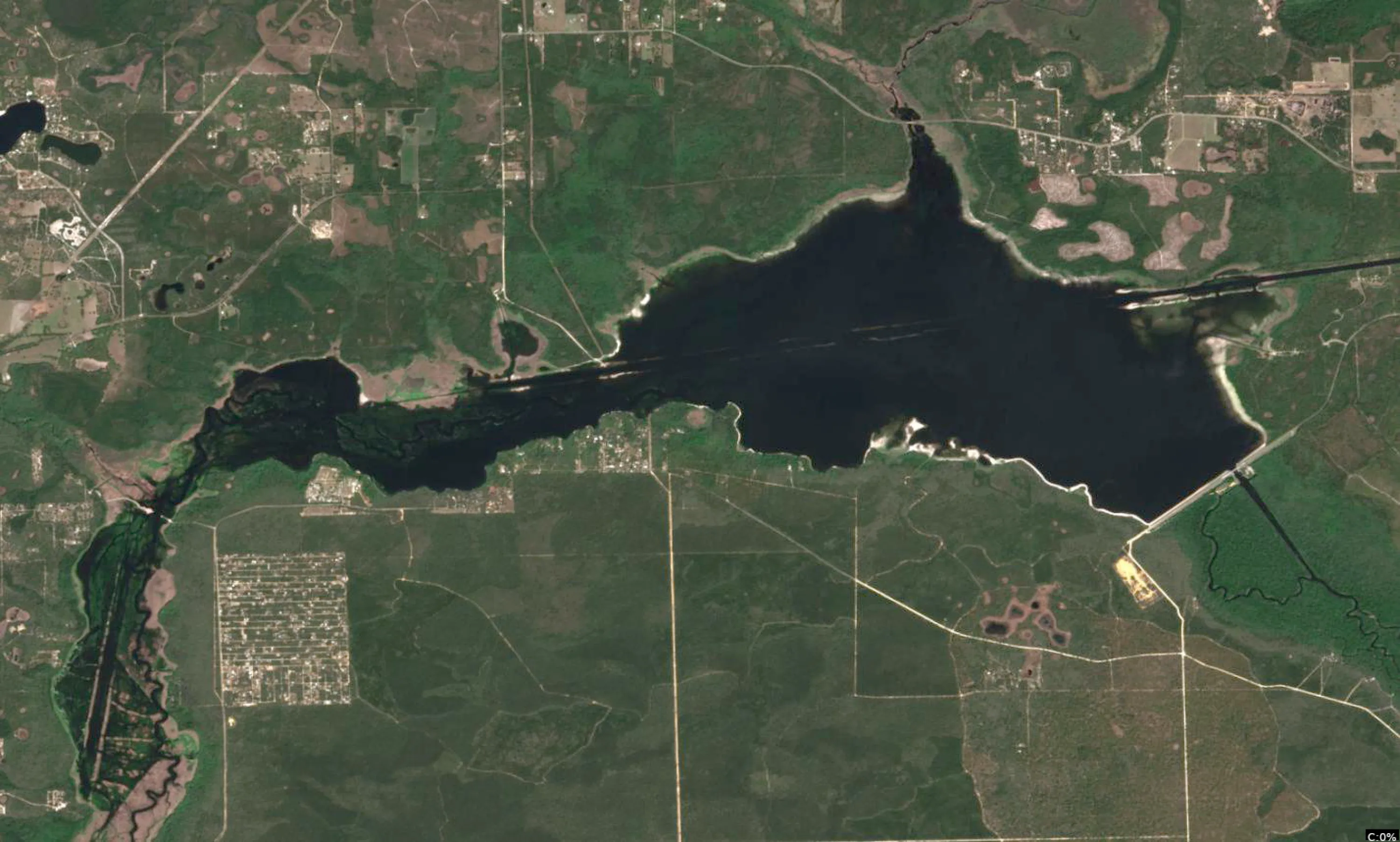
Analyze Satellite Imagery
Rodman Reservoir Satellite Analysis (Putnam County, FL - Jan 02, 2026)
1. LAKE OVERVIEW (Natural Sections & Landmarks)
Rodman Reservoir is a large, elongated north-south lake with a wide central main body flanked by narrow northern and southern sections. The main lake body dominates the center as the broadest open water area, showing scattered dark patches (stumps/vegetation) amid lighter tan shallows transitioning to medium blue. The northern section narrows into a vegetated arm with creek-like inflows visible on the east side, divided by a necked-down area with heavy green shoreline vegetation. The southern section opens up near the dam, with a distinct wide basin south of the main body, separated by a narrower channel pinch point.
Major landmarks visible:
- Boat ramps/landings: Prominent ramp on the northwest shore (likely Kenwood Landing area, with parking lot and access road); another ramp cluster on the east shore mid-lake (possibly Orange Springs or similar).
- Marinas/docks: Dense dock clusters along the northeast shore and a smaller marina setup on the southwest main lake shore.
- Bridges/roads: Road/bridge crossing visible in the northern necked-down area; dam structure at the far southern end with a road atop it.
- Islands: Several small vegetated islands in the main lake body (one prominent pair in the central area) and larger stump islands in the southern basin.
- Natural divisions: Northern arm necks down via a vegetated pinch; main body opens wide; southern section funnels toward the dam via a channel-like narrowing.
Cloud cover partially obscures the far north and east, but core water features show clear color gradients: tan/light blue shallows near shores, medium blue transitions, and darker blue pockets in channels.
2. FINDABLE FISHING SPOTS
Here are 6 high-priority, findable spots based on visible structure/cover combos, color transitions (drop-offs), and pre-spawn staging at 61°F. Prioritized for bass/crappie using docks, points, creeks near depth changes.
-
General Area: Northern section
How to Find It: Launch from the northwest boat ramp, head southeast along the shore to the first major point where the shoreline juts out.
What You See: Point with a cluster of 4-5 docks extending into medium blue water; sharp tan-to-medium blue color shift at the point tip; scattered dark stump patches offshore.
Why Fish It: Point structure with dock cover and visible drop-off creates ambush for pre-spawn bass staging from deep; crappie on docks/brush. Priority 9/10 (structure + cover + transition).
Best Approach: Pitch jigs or worms under docks; fan-cast the point edge for drop-off reaction bites. -
General Area: Main lake body - northeast shore
How to Find It: From the east shore boat ramp/marina, go north 1/4 mile to the long stretch of docks lining a gradual point.
What You See: Linear row of 10+ docks along a tan shallow flat transitioning to dark blue channel swing; serpentine dark line (channel) bending toward shore.
Why Fish It: Channel swing with heavy dock cover holds migrating bass/crappie; protected from wind. Priority 8/10 (channel structure + dense cover).
Best Approach: Run docks with spinnerbaits early, then slow drag lipless crankbait over channel edge. -
General Area: Main lake body - central islands
How to Find It: Head to the center main lake, locate the pair of small green islands with points on both sides.
What You See: Two islands surrounded by light tan shallows dropping to medium blue; points extending with visible stump clusters; color bands circling bases.
Why Fish It: Island points offer multi-directional structure for bass feeding on flats; wind protection in coves behind. Priority 9/10 (complex structure + transitions).
Best Approach: Circle islands with swimbaits; flip laydowns/stumps on windward points. -
General Area: Main lake body - southwest shore
How to Find It: From the northwest ramp, cross to southwest shore and find the small marina with adjacent cove.
What You See: Marina docks in a protected cove with tan flats; dark linear objects (laydowns) from shore into medium blue; nearby point with color drop.
Why Fish It: Cove staging area with laydown cover near drop-off perfect for pre-spawn bass; crappie around marina brush. Priority 8/10 (cover density + protection).
Best Approach: Flip Texas rigs along laydowns; suspend jerkbait over flats. -
General Area: Southern section - east arm
How to Find It: From main lake, pass the central islands south through the narrowing channel, then east into the arm where a creek mouth shows as a tan delta.
What You See: Creek inflow with dark channel line entering tan shallows; cluster of docks at the mouth; sharp medium-to-dark blue transition offshore.
Why Fish It: Creek channel mouth with docks = current funnel for catfish/bass; spawning flat access. Priority 7/10 (inflow + transition).
Best Approach: Drift cutbait or worms in channel; cast to dock edges. -
General Area: Southern basin - near dam
How to Find It: South end near the dam road, west shore cove just before the structure.
What You See: Protected cove with scattered docks and dark stump piles; tan-to-dark blue drop along the western wall.
Why Fish It: Dam proximity with stump cover and drop-off holds refuge crappie/bass; wind-sheltered. Priority 8/10 (deep transition + cover).
Best Approach: Vertical jig or drop-shot over stumps; fan the drop line.
3. VISIBLE FEATURES BY LAKE SECTION
Northern section: Narrow arm with heavy green vegetation; major point with dock cluster on east shore; creek-like dark line entering from northeast; boat ramp on northwest with adjacent docks; tan shallows along shores dropping to medium blue.
Main lake body: Wide open water with central island pair (points and stump halos); long northeast dock row on channel swing; southwest marina/cove with laydowns; scattered dark stump islands; consistent tan-medium blue gradients around points.
Southern section: Broader basin narrowing to dam; east arm creek mouth with docks; west shore cove near dam with stumps/docks; dark channel threading south; color shifts to darker blue near dam wall.
Eastern/Western arms (minor): Northeast main lake has extended arm with docks; subtle western inflows show as tan deltas but cloud-obscured.
4. PRACTICAL FISHING GUIDANCE
Suggested fishing progression (pre-spawn at 61°F - bass moving shallow, crappie on wood):
- Start (early AM): Northern section - main point with docks off northwest ramp (shallow staging, wind protection).
- Mid-morning: Move to main lake body - northeast docks/channel swing (as sun rises, fish channel edges).
- Pattern: Northern shallows → main lake points/islands midday → southern coves near dam afternoon (deeper refuge). Crappie pattern: Dock/brush clusters progressing south.
Navigation between sections:
- Northern to main lake: Head south through the vegetated neck past the road bridge.
- Main lake to southern: Pass central islands, skirt east shore through channel narrowing.
- Full loop: Northwest ramp → north points → east docks → islands → south cove → back north along west shore marina.
Focus on color edges from boat - tan flats for spawning, medium blue drops for staging. Safe boating: Watch stumps in shallows!
Findings:
-
Rodman Reservoir Satellite Analysis (Putnam County, FL - Jan 02, 2026)
1. LAKE OVERVIEW (Natural Sections & Landmarks)
Rodman Reservoir is a large, elongated north-south lake with a wide central main body flanked by narrow northern and southern sections. The main lake body dominates the center as the broadest open water area, showing scattered dark patches (stumps/vegetation) amid lighter tan shallows transitioning to medium blue. The northern section narrows into a vegetated arm with creek-like inflows visible on the east side, divided by a necked-down area with heavy green shoreline vegetation. The southern section opens up near the dam, with a distinct wide basin south of the main body, separated by a narrower channel pinch point.
Major landmarks visible:
- Boat ramps/landings: Prominent ramp on the northwest shore (likely Kenwood Landing area, with parking lot and access road); another ramp cluster on the east shore mid-lake (possibly Orange Springs or similar).
- Marinas/docks: Dense dock clusters along the northeast shore and a smaller marina setup on the southwest main lake shore.
- Bridges/roads: Road/bridge crossing visible in the northern necked-down area; dam structure at the far southern end with a road atop it.
- Islands: Several small vegetated islands in the main lake body (one prominent pair in the central area) and larger stump islands in the southern basin.
- Natural divisions: Northern arm necks down via a vegetated pinch; main body opens wide; southern section funnels toward the dam via a channel-like narrowing.
Cloud cover partially obscures the far north and east, but core water features show clear color gradients: tan/light blue shallows near shores, medium blue transitions, and darker blue pockets in channels.
2. FINDABLE FISHING SPOTS
Here are 6 high-priority, findable spots based on visible structure/cover combos, color transitions (drop-offs), and pre-spawn staging at 61°F. Prioritized for bass/crappie using docks, points, creeks near depth changes.
-
General Area: Northern section
How to Find It: Launch from the northwest boat ramp, head southeast along the shore to the first major point where the shoreline juts out.
What You See: Point with a cluster of 4-5 docks extending into medium blue water; sharp tan-to-medium blue color shift at the point tip; scattered dark stump patches offshore.
Why Fish It: Point structure with dock cover and visible drop-off creates ambush for pre-spawn bass staging from deep; crappie on docks/brush. Priority 9/10 (structure + cover + transition).
Best Approach: Pitch jigs or worms under docks; fan-cast the point edge for drop-off reaction bites. -
General Area: Main lake body - northeast shore
How to Find It: From the east shore boat ramp/marina, go north 1/4 mile to the long stretch of docks lining a gradual point.
What You See: Linear row of 10+ docks along a tan shallow flat transitioning to dark blue channel swing; serpentine dark line (channel) bending toward shore.
Why Fish It: Channel swing with heavy dock cover holds migrating bass/crappie; protected from wind. Priority 8/10 (channel structure + dense cover).
Best Approach: Run docks with spinnerbaits early, then slow drag lipless crankbait over channel edge. -
General Area: Main lake body - central islands
How to Find It: Head to the center main lake, locate the pair of small green islands with points on both sides.
What You See: Two islands surrounded by light tan shallows dropping to medium blue; points extending with visible stump clusters; color bands circling bases.
Why Fish It: Island points offer multi-directional structure for bass feeding on flats; wind protection in coves behind. Priority 9/10 (complex structure + transitions).
Best Approach: Circle islands with swimbaits; flip laydowns/stumps on windward points. -
General Area: Main lake body - southwest shore
How to Find It: From the northwest ramp, cross to southwest shore and find the small marina with adjacent cove.
What You See: Marina docks in a protected cove with tan flats; dark linear objects (laydowns) from shore into medium blue; nearby point with color drop.
Why Fish It: Cove staging area with laydown cover near drop-off perfect for pre-spawn bass; crappie around marina brush. Priority 8/10 (cover density + protection).
Best Approach: Flip Texas rigs along laydowns; suspend jerkbait over flats. -
General Area: Southern section - east arm
How to Find It: From main lake, pass the central islands south through the narrowing channel, then east into the arm where a creek mouth shows as a tan delta.
What You See: Creek inflow with dark channel line entering tan shallows; cluster of docks at the mouth; sharp medium-to-dark blue transition offshore.
Why Fish It: Creek channel mouth with docks = current funnel for catfish/bass; spawning flat access. Priority 7/10 (inflow + transition).
Best Approach: Drift cutbait or worms in channel; cast to dock edges. -
General Area: Southern basin - near dam
How to Find It: South end near the dam road, west shore cove just before the structure.
What You See: Protected cove with scattered docks and dark stump piles; tan-to-dark blue drop along the western wall.
Why Fish It: Dam proximity with stump cover and drop-off holds refuge crappie/bass; wind-sheltered. Priority 8/10 (deep transition + cover).
Best Approach: Vertical jig or drop-shot over stumps; fan the drop line.
3. VISIBLE FEATURES BY LAKE SECTION
Northern section: Narrow arm with heavy green vegetation; major point with dock cluster on east shore; creek-like dark line entering from northeast; boat ramp on northwest with adjacent docks; tan shallows along shores dropping to medium blue.
Main lake body: Wide open water with central island pair (points and stump halos); long northeast dock row on channel swing; southwest marina/cove with laydowns; scattered dark stump islands; consistent tan-medium blue gradients around points.
Southern section: Broader basin narrowing to dam; east arm creek mouth with docks; west shore cove near dam with stumps/docks; dark channel threading south; color shifts to darker blue near dam wall.
Eastern/Western arms (minor): Northeast main lake has extended arm with docks; subtle western inflows show as tan deltas but cloud-obscured.
4. PRACTICAL FISHING GUIDANCE
Suggested fishing progression (pre-spawn at 61°F - bass moving shallow, crappie on wood):
- Start (early AM): Northern section - main point with docks off northwest ramp (shallow staging, wind protection).
- Mid-morning: Move to main lake body - northeast docks/channel swing (as sun rises, fish channel edges).
- Pattern: Northern shallows → main lake points/islands midday → southern coves near dam afternoon (deeper refuge). Crappie pattern: Dock/brush clusters progressing south.
Navigation between sections:
- Northern to main lake: Head south through the vegetated neck past the road bridge.
- Main lake to southern: Pass central islands, skirt east shore through channel narrowing.
- Full loop: Northwest ramp → north points → east docks → islands → south cove → back north along west shore marina.
Focus on color edges from boat - tan flats for spawning, medium blue drops for staging. Safe boating: Watch stumps in shallows!
Analyze Thermal Patterns
Overall Thermal Landscape Summary
Assuming North is at the top of the image, East to the right, West to the left, and South at the bottom (standard orientation for satellite imagery). The lake forms an irregular, roughly oval body with three major visual anchors for reference: (1) a narrow, finger-like inlet extending northward from the southwest shore (bottom-left quadrant, appearing as a thin, elongated water arm ~1/4 image width), (2) a wide, open eastern arm/bay bulging to the right-center (covering the right half of the image, with a broad curved shoreline), and (3) a small, rounded southern lobe protruding downward from the bottom-center (a compact bulge south of the main body). Dominant colors are light orange to orange (72-78°F / 22-26°C), covering ~70% of the water surface, indicating hot summer conditions. Approximate min visible temperature: light green (60°F / 16°C) at the base of the southwest inlet; max: orange bordering on red (76-78°F / 24-26°C) in the central basin.
Detailed Thermal Feature Analysis
Temperature Breaks
- Abrupt transitions from light green/yellow-green (60-68°F / 16-20°C) to light orange/orange (72-78°F / 22-26°C) are clearly visible along the inner shoreline of the narrow southwest inlet, specifically where the cooler finger of light green (60-64°F / 16-18°C, labeled ~60°-62°) meets the warmer central basin ~1/3 up from the inlet's base.
- Sharp color shift from yellow-green (64-68°F / 18-20°C, labeled 64°-68°) to orange (76-78°F / 24-26°C) runs parallel to the northern edge of the southern lobe, starting at its western tip and extending eastward ~half the lobe's width.
- Gradual break from yellow (68-72°F / 20-22°C) to light orange (72-76°F / 22-24°C) circles the eastern arm's outer curve, most pronounced at the midpoint of the rightmost shoreline bulge.
Pockets/Patches
- Isolated light green patch (60-64°F / 16-18°C, labeled 60° adjacent to 62°) forms a small, circular pocket (~5% of inlet area) at the extreme base of the narrow southwest inlet, fully contained within the water boundaries.
- Yellow-green patch (64-68°F / 18-20°C, labeled 64° and 68°) occupies a narrow, L-shaped strip along the western shore of the eastern arm, oriented northward from the southern lobe's northeast corner.
- No distinct cool blue or dark blue pockets visible; all patches are in the warmer half of the scale.
Gradients
- Smooth gradient from yellow-green (64-68°F / 18-20°C) through yellow (68-72°F / 20-22°C) to light orange (72-76°F / 22-24°C) radiates outward from the central basin (warmest orange core labeled 68°), spanning the middle third of the main lake body toward the eastern arm.
- Subtle north-south gradient in the southern lobe, warming from yellow-green (64-68°F / 18-20°C) at its base to orange (76-78°F / 24-26°C) at the top edge adjacent to the central basin.
Uniform Areas
- Large uniform orange zone (76-78°F / 24-26°C) dominates the central basin, covering the area bounded by the three anchors (southwest inlet, eastern arm, southern lobe), with no internal color variation.
- Uniform light orange (72-76°F / 22-24°C) fills the outer eastern arm, parallel to its curved shoreline, extending from the right-center to the easternmost edge.
Insightful Fish Behavior Interpretation
In this hot summer thermal profile (dominant 72-78°F / 22-26°C orange zones), surface water is stressful for most gamefish, driving minimal midday surface activity and a preference for dawn/dusk feeding near cooler transitions. Fish will concentrate along visible temperature breaks (e.g., green-to-orange edges at the southwest inlet and southern lobe), using these 60-68°F / 16-20°C to 72-78°F / 22-26°C boundaries for comfort and ambush feeding, as the PRIME yellow-green zones (64-68°F / 18-20°C) offer peak activity temps. Cooler light green pockets (60-64°F / 16-18°C) in the southwest inlet may hold sluggish fish in structure-oriented patterns near shorelines. Uniform hot orange central basin suggests fish avoidance of open surface water, favoring edges. Focus on surface/shallow behavior: expect baitfish schools and predatory strikes at breaks where fish follow subtle warming gradients for foraging.
Satellite Correlation Analysis
No additional visible satellite imagery (e.g., standard RGB photos) provided beyond the thermal data; analysis limited to ECOSTRESS thermal patterns. The light green pocket (60-64°F / 16-18°C) at the southwest inlet base aligns with the narrow inlet geometry, likely caused by surface inflow mixing cooler water into the hotter basin. Eastern arm gradients correspond to its broad shoreline exposure, suggesting wind-mixing smoothing temps outward from the central heat. Southern lobe breaks match its protruding shape, possibly enhanced by shallow flats causing localized surface retention of warmer water. No springs or outflows clearly indicated beyond these geometry-driven patterns.
Actionable Fishing Recommendations
- Priority 1: Southwest Inlet Base Pocket – Target the circular light green patch (60-64°F / 16-18°C, labeled ~60°) at the inlet's southern terminus with slow presentations (jigs, drop-shots) early morning; fish the adjacent green-to-orange break for staging predators.
- Priority 2: Southern Lobe Northern Edge Break – Drift or cast along the sharp yellow-green (64-68°F / 18-20°C) to orange (76-78°F / 24-26°C) transition parallel to the lobe's top edge; use topwater or swimbaits at dawn/dusk for aggressive surface feeds.
- Priority 3: Eastern Arm Western Shore Strip – Fish the L-shaped yellow-green patch (64-68°F / 18-20°C, labeled 64°-68°) with crankbaits paralleling the shoreline; exploit the PRIME temps for reaction strikes.
- General Tactics: Avoid uniform central orange basin (76-78°F / 24-26°C); hug all visible breaks/gradients with finesse rigs. Time for low light when hot surface temps drop; monitor for wind pushing cooler inlet water into breaks. Image quality clear for water-land distinction—ignore adjacent land oranges as non-water.
Findings:
- Current surface temperature: 61.0°F. Fish showing moderate activity levels. Target temperature transition zones where warmer water meets cooler areas, often near inflows or wind-protected bays.
-
Overall Thermal Landscape Summary
Assuming North is at the top of the image, East to the right, West to the left, and South at the bottom (standard orientation for satellite imagery). The lake forms an irregular, roughly oval body with three major visual anchors for reference: (1) a narrow, finger-like inlet extending northward from the southwest shore (bottom-left quadrant, appearing as a thin, elongated water arm ~1/4 image width), (2) a wide, open eastern arm/bay bulging to the right-center (covering the right half of the image, with a broad curved shoreline), and (3) a small, rounded southern lobe protruding downward from the bottom-center (a compact bulge south of the main body). Dominant colors are light orange to orange (72-78°F / 22-26°C), covering ~70% of the water surface, indicating hot summer conditions. Approximate min visible temperature: light green (60°F / 16°C) at the base of the southwest inlet; max: orange bordering on red (76-78°F / 24-26°C) in the central basin.
Detailed Thermal Feature Analysis
Temperature Breaks
- Abrupt transitions from light green/yellow-green (60-68°F / 16-20°C) to light orange/orange (72-78°F / 22-26°C) are clearly visible along the inner shoreline of the narrow southwest inlet, specifically where the cooler finger of light green (60-64°F / 16-18°C, labeled ~60°-62°) meets the warmer central basin ~1/3 up from the inlet's base.
- Sharp color shift from yellow-green (64-68°F / 18-20°C, labeled 64°-68°) to orange (76-78°F / 24-26°C) runs parallel to the northern edge of the southern lobe, starting at its western tip and extending eastward ~half the lobe's width.
- Gradual break from yellow (68-72°F / 20-22°C) to light orange (72-76°F / 22-24°C) circles the eastern arm's outer curve, most pronounced at the midpoint of the rightmost shoreline bulge.
Pockets/Patches
- Isolated light green patch (60-64°F / 16-18°C, labeled 60° adjacent to 62°) forms a small, circular pocket (~5% of inlet area) at the extreme base of the narrow southwest inlet, fully contained within the water boundaries.
- Yellow-green patch (64-68°F / 18-20°C, labeled 64° and 68°) occupies a narrow, L-shaped strip along the western shore of the eastern arm, oriented northward from the southern lobe's northeast corner.
- No distinct cool blue or dark blue pockets visible; all patches are in the warmer half of the scale.
Gradients
- Smooth gradient from yellow-green (64-68°F / 18-20°C) through yellow (68-72°F / 20-22°C) to light orange (72-76°F / 22-24°C) radiates outward from the central basin (warmest orange core labeled 68°), spanning the middle third of the main lake body toward the eastern arm.
- Subtle north-south gradient in the southern lobe, warming from yellow-green (64-68°F / 18-20°C) at its base to orange (76-78°F / 24-26°C) at the top edge adjacent to the central basin.
Uniform Areas
- Large uniform orange zone (76-78°F / 24-26°C) dominates the central basin, covering the area bounded by the three anchors (southwest inlet, eastern arm, southern lobe), with no internal color variation.
- Uniform light orange (72-76°F / 22-24°C) fills the outer eastern arm, parallel to its curved shoreline, extending from the right-center to the easternmost edge.
Insightful Fish Behavior Interpretation
In this hot summer thermal profile (dominant 72-78°F / 22-26°C orange zones), surface water is stressful for most gamefish, driving minimal midday surface activity and a preference for dawn/dusk feeding near cooler transitions. Fish will concentrate along visible temperature breaks (e.g., green-to-orange edges at the southwest inlet and southern lobe), using these 60-68°F / 16-20°C to 72-78°F / 22-26°C boundaries for comfort and ambush feeding, as the PRIME yellow-green zones (64-68°F / 18-20°C) offer peak activity temps. Cooler light green pockets (60-64°F / 16-18°C) in the southwest inlet may hold sluggish fish in structure-oriented patterns near shorelines. Uniform hot orange central basin suggests fish avoidance of open surface water, favoring edges. Focus on surface/shallow behavior: expect baitfish schools and predatory strikes at breaks where fish follow subtle warming gradients for foraging.
Satellite Correlation Analysis
No additional visible satellite imagery (e.g., standard RGB photos) provided beyond the thermal data; analysis limited to ECOSTRESS thermal patterns. The light green pocket (60-64°F / 16-18°C) at the southwest inlet base aligns with the narrow inlet geometry, likely caused by surface inflow mixing cooler water into the hotter basin. Eastern arm gradients correspond to its broad shoreline exposure, suggesting wind-mixing smoothing temps outward from the central heat. Southern lobe breaks match its protruding shape, possibly enhanced by shallow flats causing localized surface retention of warmer water. No springs or outflows clearly indicated beyond these geometry-driven patterns.
Actionable Fishing Recommendations
- Priority 1: Southwest Inlet Base Pocket – Target the circular light green patch (60-64°F / 16-18°C, labeled ~60°) at the inlet's southern terminus with slow presentations (jigs, drop-shots) early morning; fish the adjacent green-to-orange break for staging predators.
- Priority 2: Southern Lobe Northern Edge Break – Drift or cast along the sharp yellow-green (64-68°F / 18-20°C) to orange (76-78°F / 24-26°C) transition parallel to the lobe's top edge; use topwater or swimbaits at dawn/dusk for aggressive surface feeds.
- Priority 3: Eastern Arm Western Shore Strip – Fish the L-shaped yellow-green patch (64-68°F / 18-20°C, labeled 64°-68°) with crankbaits paralleling the shoreline; exploit the PRIME temps for reaction strikes.
- General Tactics: Avoid uniform central orange basin (76-78°F / 24-26°C); hug all visible breaks/gradients with finesse rigs. Time for low light when hot surface temps drop; monitor for wind pushing cooler inlet water into breaks. Image quality clear for water-land distinction—ignore adjacent land oranges as non-water.
- Winter surface patterns: Target the warmest surface areas during midday, typically along north-facing shorelines and sun-exposed areas. Use slow presentations as fish metabolism is reduced.
Analyze Water Clarity
1. Overall Water Quality Summary
The imagery reveals a reservoir dominated by clear to moderately stained conditions, with a large central main basin showing dark blue/teal colors indicative of low sediment + low chlorophyll (bottom-left quadrant: clearest water, 15-25+ ft visibility). Peripheral areas, particularly northern arms, eastern coves, and southern flats, exhibit bright green/yellow patches (bottom-right quadrant: high chlorophyll + low sediment, 3-8 ft visibility) overlaid with patchy brown/tan intrusions (top-left/top-center: high sediment + low/moderate chlorophyll, 1-6 ft visibility). Combined visuals show transitions from premium clear water in the deep main body to algae-influenced stained zones along shorelines and turbid sediment plumes in inflow-adjacent shallows, creating high-productivity edges.
2. Detailed Clarity Zone Mapping & Characterization (3-5 Key Zones with locations, categories, causes)
Zone 1: Central Main Basin (Dark Blue/Teal - Bottom-Left Quadrant)
- Matrix Position Analysis: Predominant dark blue/teal across the broad central reservoir body, south of the northern arms.
- Combined Conditions: Low sediment + low chlorophyll = minimal particles/algae, 15-25+ ft visibility; premium sight-fishing water.
- Location Mapping: Core of the reservoir, spanning from mid-lake southward to the southern shoreline, excluding peripheral coves (e.g., central deep water west of the eastern arm).
- Tactical Implications: Finesse tactics essential; stealthy approaches for pressured fish.
- Transition Zone Identification: Sharp edges where teal meets encroaching greens to the north/northeast.
Zone 2: Northern Arm and Shallows (Bright Green/Yellow - Bottom-Right Quadrant)
- Matrix Position Analysis: Intense bright green/yellow clusters filling the upper/northern extension.
- Combined Conditions: High chlorophyll + low sediment = algae bloom in clear base water, 3-8 ft visibility; green-tinted but fishable.
- Location Mapping: Northeast arm protruding northward, plus adjacent western shoreline pockets (e.g., northernmost cove near inferred creek inflow).
- Tactical Implications: Vibration aids penetration through algae; target edges for reaction bites.
- Transition Zone Identification: Gradual fade from yellow-green southward into central teal basin.
Zone 3: Eastern Coves and Mid-Lake Patches (Green/Yellow with Brown Overlays - Top-Center Quadrant)
- Matrix Position Analysis: Green/yellow bases with brown/tan mottling in eastern protrusions.
- Combined Conditions: Moderate chlorophyll + high sediment = stained productive water, 1-4 ft visibility; algae + stirred particles.
- Location Mapping: Eastern shoreline coves and mid-eastern bays, extending from northeast arm base southeastward.
- Tactical Implications: Loud, slow presentations to overcome combined staining.
- Transition Zone Identification: Patchy brown-green mixes creating irregular edges with adjacent teal zones.
Zone 4: Southern Flats and Inflow Areas (Brown/Tan Dominant - Top-Left Quadrant)
- Matrix Position Analysis: Concentrated brown/tan patches across southern shallows.
- Combined Conditions: High sediment + low chlorophyll = muddy runoff water, 2-6 ft visibility; sediment-heavy but low algae.
- Location Mapping: Southern shoreline flats and central-southern band (e.g., near southern creek mouths or wind-exposed shallows).
- Tactical Implications: Maximum noise/vibration; power fishing viable.
- Transition Zone Identification: Distinct mudlines where tan meets central teal to the north.
Zone 5: Patchy Western Shoreline (Brown/Green Mix - Top-Center Quadrant)
- Matrix Position Analysis: Scattered brown/green mottles along western edges.
- Combined Conditions: Moderate chlorophyll + high sediment = challenging stained water, 1-4 ft visibility.
- Location Mapping: Western shoreline from mid-lake north to arm base (e.g., near visible docks or points).
- Tactical Implications: Hybrid loud/natural baits at transitions.
- Transition Zone Identification: Wind-stirred edges blending into main teal basin.
3. Turbidity/Algae Sources & Transition Zones Analysis
Source Identification (Visual): High chlorophyll (green/yellow) sources appear concentrated in protected northern/eastern shallows and coves, likely nutrient-rich inflows or wind-sheltered algae growth. Turbidity (brown/tan) sources are patchy but prominent in southern flats and eastern/western shorelines, suggesting wind-blown sediment from shallows, runoff from southern inflows, or stirred bottom in exposed areas. No extreme top-right dark brown/red mixes observed, indicating no "worst-case" particle-algae overload.
Clarity Breaks/Edges:
- Sharp mudlines (tan-brown meeting teal) run north-south along the southern third of the main basin, creating ambush points where bait concentrates.
- Gradual green-to-teal shifts along the northern arm's southern edge and eastern coves, ideal for predator staging.
- Patchy brown-green transitions in mid-eastern bays offer irregular "clarity walls" for fish to hold on the clearer side. These edges signify high fishing potential as forage gathers at density changes, with bass/crappie ambushing from stained into clear water.
4. Species-Specific Clarity Strategy (Recommendations tied to zones)
- Largemouth Bass (primary for Rodman Reservoir): Patrol transition edges like the northern green-teal boundary (Zone 2-1) and southern tan-teal mudline (Zone 4-1); aggressive in stained eastern coves (Zone 3).
- Crappie: Suspend near cover in moderate green zones (Zone 2, northern arm) or at high-algae edges (e.g., northeast cove transitions), avoiding deepest teal.
- Catfish: Bottom-feed in turbid southern flats (Zone 4) and western brown mixes (Zone 5), using structure in low-visibility patches.
- Sight-feeders/Walleye analogs: Concentrate in central teal basin (Zone 1, main body west of eastern arm) for deepest clarity.
5. Tactical Fishing Adjustments (Lures/Presentations tied to zones)
Zone 1 (Clear Teal, 15-25+ ft): Natural colors (green pumpkin, watermelon seed) on jigs/soft plastics; finesse slow drags, long casts (40+ yd), fluorocarbon 8-12 lb; stealth boat positioning. Zone 2 (Green/Yellow Algae, 3-8 ft): Bright chartreuse/white chatterbaits/spinnerbaits; moderate-fast retrieves with vibration to trigger through tint; target edges with suspending jerkbaits. Zone 3 (Stained Brown/Green, 1-4 ft): Black/blue or orange/chartreuse lipless cranks/big worms; slow rolling with rattles, scent-enhanced; fish irregular patches aggressively. Zone 4 (Muddy Tan, 2-6 ft): High-contrast white/chartreuse 1/2 oz spinnerbaits/large swimbaits; steady retrieve with max noise; short 10-20 yd casts, braided 15-20 lb OK. Zone 5 (Western Brown/Green, 1-4 ft): Bright bluegill patterns or green pumpkin Texas rigs; hybrid slow-finesse with vibration; longer casts to edges.
Fishing Clarity Breaks: Parallel the mudline/green edges with reaction baits (e.g., along southern teal-tan wall, fan-cast from clear side); slow-roll jigs perpendicular to northern transitions to probe ambush depths.
6. Seasonal Context (Interpretation of visual patterns)
The visuals show moderate algae blooms confined to shallows (greens in northern/eastern arms) and localized sediment plumes (southern tans), consistent with fall turnover or wind-stirred conditions at 61°F—active but not extreme, with fish responding to transitions. The resilient deep teal main basin maintains clarity despite peripheral turbidity, suggesting stable deep-water refuge amid typical seasonal mixing; no signs of unusual summer-like heavy blooms or spring flood overload.
Findings:
-
1. Overall Water Quality Summary
The imagery reveals a reservoir dominated by clear to moderately stained conditions, with a large central main basin showing dark blue/teal colors indicative of low sediment + low chlorophyll (bottom-left quadrant: clearest water, 15-25+ ft visibility). Peripheral areas, particularly northern arms, eastern coves, and southern flats, exhibit bright green/yellow patches (bottom-right quadrant: high chlorophyll + low sediment, 3-8 ft visibility) overlaid with patchy brown/tan intrusions (top-left/top-center: high sediment + low/moderate chlorophyll, 1-6 ft visibility). Combined visuals show transitions from premium clear water in the deep main body to algae-influenced stained zones along shorelines and turbid sediment plumes in inflow-adjacent shallows, creating high-productivity edges.
2. Detailed Clarity Zone Mapping & Characterization (3-5 Key Zones with locations, categories, causes)
Zone 1: Central Main Basin (Dark Blue/Teal - Bottom-Left Quadrant)
- Matrix Position Analysis: Predominant dark blue/teal across the broad central reservoir body, south of the northern arms.
- Combined Conditions: Low sediment + low chlorophyll = minimal particles/algae, 15-25+ ft visibility; premium sight-fishing water.
- Location Mapping: Core of the reservoir, spanning from mid-lake southward to the southern shoreline, excluding peripheral coves (e.g., central deep water west of the eastern arm).
- Tactical Implications: Finesse tactics essential; stealthy approaches for pressured fish.
- Transition Zone Identification: Sharp edges where teal meets encroaching greens to the north/northeast.
Zone 2: Northern Arm and Shallows (Bright Green/Yellow - Bottom-Right Quadrant)
- Matrix Position Analysis: Intense bright green/yellow clusters filling the upper/northern extension.
- Combined Conditions: High chlorophyll + low sediment = algae bloom in clear base water, 3-8 ft visibility; green-tinted but fishable.
- Location Mapping: Northeast arm protruding northward, plus adjacent western shoreline pockets (e.g., northernmost cove near inferred creek inflow).
- Tactical Implications: Vibration aids penetration through algae; target edges for reaction bites.
- Transition Zone Identification: Gradual fade from yellow-green southward into central teal basin.
Zone 3: Eastern Coves and Mid-Lake Patches (Green/Yellow with Brown Overlays - Top-Center Quadrant)
- Matrix Position Analysis: Green/yellow bases with brown/tan mottling in eastern protrusions.
- Combined Conditions: Moderate chlorophyll + high sediment = stained productive water, 1-4 ft visibility; algae + stirred particles.
- Location Mapping: Eastern shoreline coves and mid-eastern bays, extending from northeast arm base southeastward.
- Tactical Implications: Loud, slow presentations to overcome combined staining.
- Transition Zone Identification: Patchy brown-green mixes creating irregular edges with adjacent teal zones.
Zone 4: Southern Flats and Inflow Areas (Brown/Tan Dominant - Top-Left Quadrant)
- Matrix Position Analysis: Concentrated brown/tan patches across southern shallows.
- Combined Conditions: High sediment + low chlorophyll = muddy runoff water, 2-6 ft visibility; sediment-heavy but low algae.
- Location Mapping: Southern shoreline flats and central-southern band (e.g., near southern creek mouths or wind-exposed shallows).
- Tactical Implications: Maximum noise/vibration; power fishing viable.
- Transition Zone Identification: Distinct mudlines where tan meets central teal to the north.
Zone 5: Patchy Western Shoreline (Brown/Green Mix - Top-Center Quadrant)
- Matrix Position Analysis: Scattered brown/green mottles along western edges.
- Combined Conditions: Moderate chlorophyll + high sediment = challenging stained water, 1-4 ft visibility.
- Location Mapping: Western shoreline from mid-lake north to arm base (e.g., near visible docks or points).
- Tactical Implications: Hybrid loud/natural baits at transitions.
- Transition Zone Identification: Wind-stirred edges blending into main teal basin.
3. Turbidity/Algae Sources & Transition Zones Analysis
Source Identification (Visual): High chlorophyll (green/yellow) sources appear concentrated in protected northern/eastern shallows and coves, likely nutrient-rich inflows or wind-sheltered algae growth. Turbidity (brown/tan) sources are patchy but prominent in southern flats and eastern/western shorelines, suggesting wind-blown sediment from shallows, runoff from southern inflows, or stirred bottom in exposed areas. No extreme top-right dark brown/red mixes observed, indicating no "worst-case" particle-algae overload.
Clarity Breaks/Edges:
- Sharp mudlines (tan-brown meeting teal) run north-south along the southern third of the main basin, creating ambush points where bait concentrates.
- Gradual green-to-teal shifts along the northern arm's southern edge and eastern coves, ideal for predator staging.
- Patchy brown-green transitions in mid-eastern bays offer irregular "clarity walls" for fish to hold on the clearer side. These edges signify high fishing potential as forage gathers at density changes, with bass/crappie ambushing from stained into clear water.
4. Species-Specific Clarity Strategy (Recommendations tied to zones)
- Largemouth Bass (primary for Rodman Reservoir): Patrol transition edges like the northern green-teal boundary (Zone 2-1) and southern tan-teal mudline (Zone 4-1); aggressive in stained eastern coves (Zone 3).
- Crappie: Suspend near cover in moderate green zones (Zone 2, northern arm) or at high-algae edges (e.g., northeast cove transitions), avoiding deepest teal.
- Catfish: Bottom-feed in turbid southern flats (Zone 4) and western brown mixes (Zone 5), using structure in low-visibility patches.
- Sight-feeders/Walleye analogs: Concentrate in central teal basin (Zone 1, main body west of eastern arm) for deepest clarity.
5. Tactical Fishing Adjustments (Lures/Presentations tied to zones)
Zone 1 (Clear Teal, 15-25+ ft): Natural colors (green pumpkin, watermelon seed) on jigs/soft plastics; finesse slow drags, long casts (40+ yd), fluorocarbon 8-12 lb; stealth boat positioning. Zone 2 (Green/Yellow Algae, 3-8 ft): Bright chartreuse/white chatterbaits/spinnerbaits; moderate-fast retrieves with vibration to trigger through tint; target edges with suspending jerkbaits. Zone 3 (Stained Brown/Green, 1-4 ft): Black/blue or orange/chartreuse lipless cranks/big worms; slow rolling with rattles, scent-enhanced; fish irregular patches aggressively. Zone 4 (Muddy Tan, 2-6 ft): High-contrast white/chartreuse 1/2 oz spinnerbaits/large swimbaits; steady retrieve with max noise; short 10-20 yd casts, braided 15-20 lb OK. Zone 5 (Western Brown/Green, 1-4 ft): Bright bluegill patterns or green pumpkin Texas rigs; hybrid slow-finesse with vibration; longer casts to edges.
Fishing Clarity Breaks: Parallel the mudline/green edges with reaction baits (e.g., along southern teal-tan wall, fan-cast from clear side); slow-roll jigs perpendicular to northern transitions to probe ambush depths.
6. Seasonal Context (Interpretation of visual patterns)
The visuals show moderate algae blooms confined to shallows (greens in northern/eastern arms) and localized sediment plumes (southern tans), consistent with fall turnover or wind-stirred conditions at 61°F—active but not extreme, with fish responding to transitions. The resilient deep teal main basin maintains clarity despite peripheral turbidity, suggesting stable deep-water refuge amid typical seasonal mixing; no signs of unusual summer-like heavy blooms or spring flood overload.
How this was synthesized
Professional fishing guide analysis integrating 11 tools: analyze_hourly_conditions, estimate_seasonal_phase, lure_matrix_wind_clarity, analyze_solunar_timing, get_community_reports, analyze_weather_conditions, analyze_species_behavior, analyze_pressure_trends, analyze_satellite_imagery, analyze_thermal_patterns, analyze_water_clarity. User request: 'Generate a comprehensive fishing report for Rodman Reservoir. Use tools to analyze satellite structure, thermal patterns, water clarity, weather, and solunar timing, then synthesize a concise plan.'. Synthesis generated comprehensive plan with professional recommendations.