Salmon Falls Creek Reservoir Fishing Report
Synthesis generated comprehensive plan with professional recommendations.
Salmon Falls Creek Reservoir Fishing Report
Generated Jan 24, 2026, 11:45 AM.
Key fishing read
- Rising pressure trend (1026.00 → higher). Bite may slow down as fish become less active.
- Switch to finesse tactics, target deeper structure. Fish will be less aggressive.
- Day 1: High pressure (1026mb) - tougher bite, use finesse tactics
- Day 1: High winds (30mph) - seek protected areas, use heavier lures
- Day 1: MostlyClear, High: 29°F, Low: 15°F
- Day 2: High pressure (1027mb) - tougher bite, use finesse tactics
- Day 2: High winds (36mph) - seek protected areas, use heavier lures
- Day 2: Clear, High: 35°F, Low: 19°F
Tool analysis details
Analyze Pressure Trends
Barometric pressure analysis for Salmon Falls Creek Reservoir: rising trend at 1026.00mb
Findings:
- Rising pressure trend (1026.00 → higher). Bite may slow down as fish become less active.
- Switch to finesse tactics, target deeper structure. Fish will be less aggressive.
Analyze Weather Conditions
Weather analysis for Salmon Falls Creek Reservoir completed
Findings:
- Day 1: High pressure (1026mb) - tougher bite, use finesse tactics
- Day 1: High winds (30mph) - seek protected areas, use heavier lures
- Day 1: MostlyClear, High: 29°F, Low: 15°F
- Day 2: High pressure (1027mb) - tougher bite, use finesse tactics
- Day 2: High winds (36mph) - seek protected areas, use heavier lures
Analyze Species Behavior
Species behavior analysis for Salmon Falls Creek Reservoir completed
Findings:
- walleye: Cold water active (36.0°F), target deep edges with live bait or slow jigs
- walleye: sluggish activity at 36.0°F (optimal: 45-65°F)
Analyze Thermal Patterns
Overall Thermal Landscape Summary
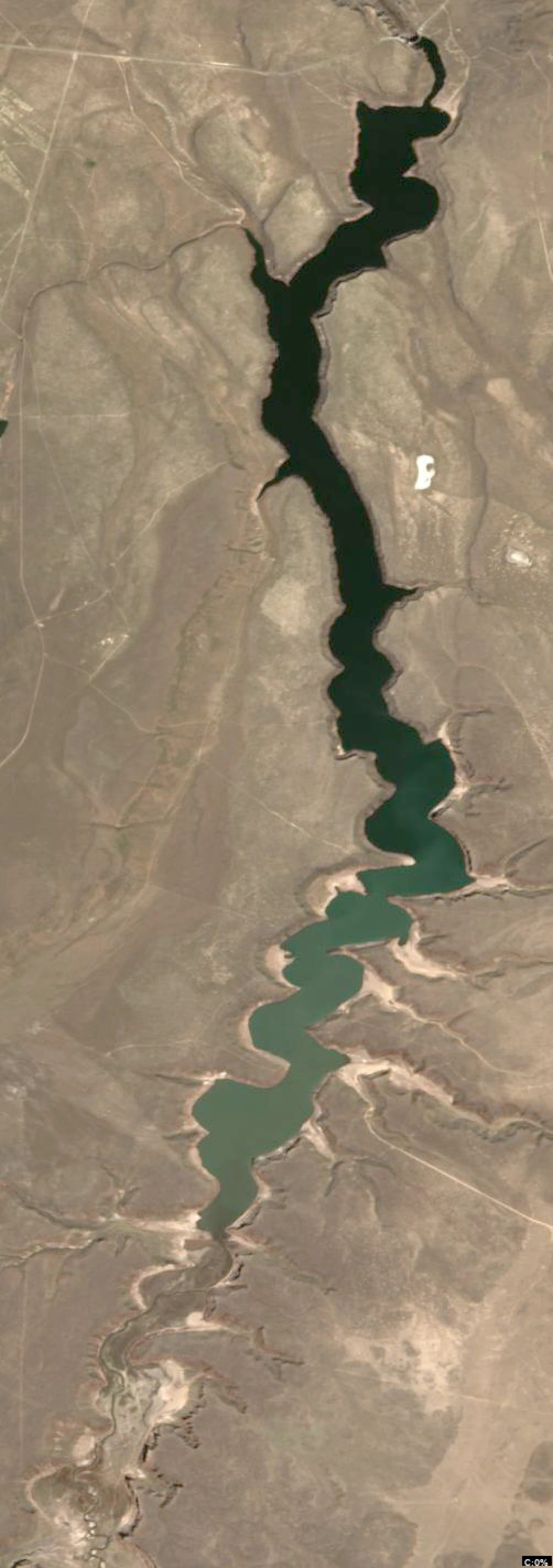
Assuming North is at the top of the image, East to the right, West to the left, and South at the bottom. The lake appears as a long, narrow, irregularly shaped body of water, resembling an elongated riverine lake with a wider northern section tapering into a sinuous central channel and a broader southern basin. Major visual anchors include: (1) the wide, bulbous northern end with jagged eastern shoreline, (2) the prominent narrow constriction in the central third flanked by tight embayments on both sides, and (3) the flared southern terminus with a deep western indentation. The entire water body displays a highly uniform dark blue color (42-46°F / 6-8°C), with no discernible variations, gradients, or color shifts visible. Approximate min/max surface temperatures: consistently 42-46°F (6-8°C) across all water areas.
Detailed Thermal Feature Analysis
Temperature Breaks
No temperature breaks or abrupt color transitions are clearly visible anywhere in the image. The dark blue coloration remains consistent without boundaries between warmer or cooler zones.
Pockets/Patches
No distinct pockets or patches of differing colors (e.g., no lighter blue, cyan, green, or warmer hues) are observable. The water surface shows no isolated thermal anomalies.
Gradients
No gradual color gradients or transitions are visible. The dark blue tone is uniform throughout the water body, from the northern bulb to the southern basin.
Uniform Areas
The entire lake water area—from the wide northern anchor, through the central constriction, to the southern flared end—exhibits uniform dark blue coloring (42-46°F / 6-8°C). Shoreline transitions show no clear water-side patterns differentiating from potential land areas, which are not distinctly warmer or cooler in the visible data.
Insightful Fish Behavior Interpretation
In uniform dark blue surface water (42-46°F / 6-8°C), fish activity is expected to be very slow and limited, characteristic of late winter/very early spring conditions. Fish are likely sluggish, with minimal surface feeding and a preference for holding near structure in deeper patterns rather than actively patrolling open water. Surface-oriented behavior will be rare due to the consistently cold temperatures suppressing metabolism; any activity would concentrate during extended low-light feeding windows near shorelines or inflows, but no such thermal cues are visible to pinpoint preferences.
Satellite Correlation Analysis
No additional satellite imagery (e.g., visible light photos, topographic overlays) is provided or visible alongside the thermal data. Thermal patterns cannot be correlated with surface structures like inflows, springs, or wind-mixing zones. The uniform cold surface suggests stable, unmixed conditions across the lake, potentially due to limited wind exposure in this narrow shape, but this is not visually supported by structural features.
Actionable Fishing Recommendations
Given the uniform dark blue surface temperatures (42-46°F / 6-8°C) with no visible thermal variations, prioritize slow presentations (e.g., dead-stick suspending baits or vertical jigging) in shallow structure areas near the major anchors: the jagged northern bulb, central constriction embayments, and southern western indentation. Focus on dawn/dusk windows along any shoreline geometry (e.g., the tight eastern embayments in the central section) where fish may seek subtle comfort despite uniformity. Avoid open water; target potential inflows at the northern end if accessible, as uniform cold water limits surface hotspots. Image quality supports only general shoreline strategies—probe slowly for any unobservable depth-related holds.
Findings:
- Current surface temperature: 36.0°F. Fish metabolism significantly reduced in cold water. Target sunny, protected shorelines and use extremely slow presentations. Focus on midday when surface temperatures are warmest.
-
Overall Thermal Landscape Summary
Assuming North is at the top of the image, East to the right, West to the left, and South at the bottom. The lake appears as a long, narrow, irregularly shaped body of water, resembling an elongated riverine lake with a wider northern section tapering into a sinuous central channel and a broader southern basin. Major visual anchors include: (1) the wide, bulbous northern end with jagged eastern shoreline, (2) the prominent narrow constriction in the central third flanked by tight embayments on both sides, and (3) the flared southern terminus with a deep western indentation. The entire water body displays a highly uniform dark blue color (42-46°F / 6-8°C), with no discernible variations, gradients, or color shifts visible. Approximate min/max surface temperatures: consistently 42-46°F (6-8°C) across all water areas.
Detailed Thermal Feature Analysis
Temperature Breaks
No temperature breaks or abrupt color transitions are clearly visible anywhere in the image. The dark blue coloration remains consistent without boundaries between warmer or cooler zones.
Pockets/Patches
No distinct pockets or patches of differing colors (e.g., no lighter blue, cyan, green, or warmer hues) are observable. The water surface shows no isolated thermal anomalies.
Gradients
No gradual color gradients or transitions are visible. The dark blue tone is uniform throughout the water body, from the northern bulb to the southern basin.
Uniform Areas
The entire lake water area—from the wide northern anchor, through the central constriction, to the southern flared end—exhibits uniform dark blue coloring (42-46°F / 6-8°C). Shoreline transitions show no clear water-side patterns differentiating from potential land areas, which are not distinctly warmer or cooler in the visible data.
Insightful Fish Behavior Interpretation
In uniform dark blue surface water (42-46°F / 6-8°C), fish activity is expected to be very slow and limited, characteristic of late winter/very early spring conditions. Fish are likely sluggish, with minimal surface feeding and a preference for holding near structure in deeper patterns rather than actively patrolling open water. Surface-oriented behavior will be rare due to the consistently cold temperatures suppressing metabolism; any activity would concentrate during extended low-light feeding windows near shorelines or inflows, but no such thermal cues are visible to pinpoint preferences.
Satellite Correlation Analysis
No additional satellite imagery (e.g., visible light photos, topographic overlays) is provided or visible alongside the thermal data. Thermal patterns cannot be correlated with surface structures like inflows, springs, or wind-mixing zones. The uniform cold surface suggests stable, unmixed conditions across the lake, potentially due to limited wind exposure in this narrow shape, but this is not visually supported by structural features.
Actionable Fishing Recommendations
Given the uniform dark blue surface temperatures (42-46°F / 6-8°C) with no visible thermal variations, prioritize slow presentations (e.g., dead-stick suspending baits or vertical jigging) in shallow structure areas near the major anchors: the jagged northern bulb, central constriction embayments, and southern western indentation. Focus on dawn/dusk windows along any shoreline geometry (e.g., the tight eastern embayments in the central section) where fish may seek subtle comfort despite uniformity. Avoid open water; target potential inflows at the northern end if accessible, as uniform cold water limits surface hotspots. Image quality supports only general shoreline strategies—probe slowly for any unobservable depth-related holds.
- Winter surface patterns: Target the warmest surface areas during midday, typically along north-facing shorelines and sun-exposed areas. Use slow presentations as fish metabolism is reduced.
Analyze Water Clarity
1. Overall Water Quality Summary
The imagery reveals predominantly clear conditions across the main basin of Salmon Falls Creek Reservoir, characterized by extensive dark blue/teal areas indicative of low sediment + low chlorophyll (bottom-left quadrant), suggesting 15-25+ feet visibility in the central reservoir. Peripheral shorelines and northern arms show moderate chlorophyll with low sediment (green, bottom-center), transitioning to higher sediment loads (brown/tan, top-left) along southern shorelines and narrow southern extensions, with isolated orange/red patches (bottom-right/high chlorophyll low sediment) in central-southern pockets. Overall, the reservoir exhibits a gradient from premium clear water centrally to stained/muddy margins southward, with clarity breaks along edges highlighting productive transition zones.
2. Detailed Clarity Zone Mapping & Characterization (3-5 Key Zones with locations, categories, causes)
Zone 1: Central Main Basin (Dark Blue/Teal - Bottom-Left Quadrant)
- Matrix Position Analysis: Dark blue/teal dominates the broad central reservoir interior, from mid-northern to mid-southern extents.
- Combined Conditions: Low sediment + low chlorophyll = minimal particles and algae, yielding 15-25+ feet visibility; premium sight fishing conditions.
- Location Mapping: Core of the reservoir, spanning east-west across the widest central section, bounded by green shorelines.
- Visibility Assessment/Tactical Implications: Extremely clear water demands stealthy, natural finesse presentations; ideal for precise lure placement near subtle structure.
Zone 2: Northern Shorelines and Arms (Green - Bottom-Center Quadrant)
- Matrix Position Analysis: Vibrant green outlines along the northern half's irregular shorelines, arms, and coves.
- Combined Conditions: Moderate chlorophyll + low sediment = productive clear water with slight green tint, 8-15 feet visibility.
- Location Mapping: Northern third, hugging western and eastern shorelines, extending into protruding northern arms and bays.
- Visibility Assessment/Tactical Implications: Excellent for mixed natural/bright colors with standard retrieves; algae edges hold baitfish.
Zone 3: Southern Shoreline Extensions and Flats (Brown/Tan - Top-Left Quadrant)
- Matrix Position Analysis: Prominent brown/tan bands along the southern half's edges, filling narrow southern channels and bays.
- Combined Conditions: Low chlorophyll + high sediment = muddy conditions from stirred particles, 2-6 feet visibility.
- Location Mapping: Southern quarter, concentrated along the eastern shoreline and protruding into the southernmost narrow arm; also patches along western southern shore.
- Visibility Assessment/Tactical Implications: Classic muddy water requires high-contrast, noisy baits; power fishing viable despite cold temps.
Zone 4: Central-Southern Orange/Red Patches (Yellow/Red - Bottom-Right Quadrant)
- Matrix Position Analysis: Scattered orange/red tinges amid greens and tans in the central-southern transition.
- Combined Conditions: High chlorophyll + low sediment = clear water algae bloom, 3-8 feet visibility with stained tint.
- Location Mapping: Mid-southern pockets, near eastern shore intersections with central basin (e.g., small bays east of main channel).
- Visibility Assessment/Tactical Implications: Bright vibration baits target bloom edges; reaction strikes likely.
Zone 5: Mixed Brown/Green Southern Margins (Brown/Green Mix - Top-Center Quadrant)
- Matrix Position Analysis: Blended brown/green hues where tan meets green in southern extremities.
- Combined Conditions: Moderate chlorophyll + high sediment = stained productive water, 1-4 feet visibility.
- Location Mapping: Southernmost edges, blending into tan zones along western and eastern narrows.
- Visibility Assessment/Tactical Implications: Loud, slow presentations essential; challenging but fishable with vibration.
3. Turbidity/Algae Sources & Transition Zones Analysis
Source Identification (Visual): High sediment (brown/tan) appears sourced from southern shorelines and narrow extensions, likely wind-stirred shallows or minor inflows eroding banks in the southern arm. Moderate-to-high chlorophyll (greens, orange/red) concentrates along northern and central shorelines, suggesting nutrient inputs from protected coves or shoreline vegetation; isolated red patches indicate localized algae blooms in mid-southern bays.
Clarity Breaks/Edges:
- Sharp green-to-dark blue transitions encircle the central basin (e.g., along northern and central shorelines), forming shoreline "clarity walls" ideal for ambush points.
- Gradual tan-to-green/brown-green mixes in the southern half create east-west mudlines across narrow channels (e.g., southern third's eastern shore).
- Distinct orange/red intrusions into blue/teal near central-southern east side mark algae-sediment edges. These transitions signify high productivity as baitfish aggregate at color shifts, drawing predators; fish the outer edges of turbid zones (tan into blue) for bass reactions and inner clear zones for finesse.
4. Species-Specific Clarity Strategy (Recommendations tied to zones)
- Bass: Target Zone 3 (southern brown/tan) edges and Zone 5 (brown/green mixes) for ambush patrols along mudlines; also Zone 2 (northern greens) shorelines where moderate algae holds shad—cast parallel to eastern northern arms.
- Walleye: Focus on Zone 1 (central dark blue/teal) depths for low-light sight feeding, transitioning to Zone 4 (central-southern orange/red) bloom edges in the eastern mid-southern bays for night/low-vis activity.
- Crappie: Suspend near cover in Zone 2 (northern green shorelines) and Zone 1 (central basin) clarity breaks; vertical jig along western northern coves where green meets blue.
- Catfish: Power fish Zone 3 (southern tan flats) and Zone 5 (southern mixes) near bottom structure in high-sediment lows; drift baits along eastern southern shorelines.
5. Tactical Fishing Adjustments (Lures/Presentations tied to zones)
Zone 1 (Clear Dark Blue/Teal): Natural colors (green pumpkin, watermelon seed); finesse jigs, Ned rigs, small swimbaits on fluorocarbon 8-12lb; long casts (40+ yards), slow retrieves—downsize 25% for 36°F cold, stealth boat positioning. Fish clarity breaks by hovering lures in the blue-green interface.
Zone 2 (Green): Mix natural/bright (shad, chartreuse); soft plastics, suspending jerkbaits; moderate retrieves, 20-30 yard casts on 12lb fluoro/mono. Target edges with subtle twitches along northern western shorelines.
Zone 3 (Brown/Tan): High-contrast (black/blue, chartreuse/orange); 1/2oz spinnerbaits, lipless crankbaits with rattles on 15lb braid; aggressive short casts (10-20 yards), steady vibration. Power through mudlines from boat close to southern eastern shore.
Zone 4 (Yellow/Red): Bright blues/chartreuse; chatterbaits, bright crankbaits; fast retrieves to trigger reactions at bloom edges in eastern mid-southern pockets—use noise to penetrate tint.
Zone 5 (Brown/Green Mix): Loud rattles in bright white/chartreuse; big worms, slow finesse power baits on 12-15lb mono; very slow with pauses. Drift across southern narrows' transitions.
Clarity Breaks General: Long casts parallel to edges (e.g., tan-blue southern lines); alternate finesse/power at transitions for reaction strikes; incorporate scent in cold water.
6. Seasonal Context (Interpretation of visual patterns)
The extensive dark blue/teal clarity in the main basin amid peripheral staining suggests resilient core conditions despite margin turbidity, consistent with cold-water stability (36°F) where wind or minor inflows stir southern shallows without widespread impact. Localized green algae along northern shores and orange/red patches appear typical for nutrient pockets in cooler periods, while heavy southern tan turbidity indicates recent localized disturbance (e.g., wind-blown flats or inflow), not extreme bloom escalation—central clarity resilience points to fishable deep zones year-round.
Findings:
-
1. Overall Water Quality Summary
The imagery reveals predominantly clear conditions across the main basin of Salmon Falls Creek Reservoir, characterized by extensive dark blue/teal areas indicative of low sediment + low chlorophyll (bottom-left quadrant), suggesting 15-25+ feet visibility in the central reservoir. Peripheral shorelines and northern arms show moderate chlorophyll with low sediment (green, bottom-center), transitioning to higher sediment loads (brown/tan, top-left) along southern shorelines and narrow southern extensions, with isolated orange/red patches (bottom-right/high chlorophyll low sediment) in central-southern pockets. Overall, the reservoir exhibits a gradient from premium clear water centrally to stained/muddy margins southward, with clarity breaks along edges highlighting productive transition zones.
2. Detailed Clarity Zone Mapping & Characterization (3-5 Key Zones with locations, categories, causes)
Zone 1: Central Main Basin (Dark Blue/Teal - Bottom-Left Quadrant)
- Matrix Position Analysis: Dark blue/teal dominates the broad central reservoir interior, from mid-northern to mid-southern extents.
- Combined Conditions: Low sediment + low chlorophyll = minimal particles and algae, yielding 15-25+ feet visibility; premium sight fishing conditions.
- Location Mapping: Core of the reservoir, spanning east-west across the widest central section, bounded by green shorelines.
- Visibility Assessment/Tactical Implications: Extremely clear water demands stealthy, natural finesse presentations; ideal for precise lure placement near subtle structure.
Zone 2: Northern Shorelines and Arms (Green - Bottom-Center Quadrant)
- Matrix Position Analysis: Vibrant green outlines along the northern half's irregular shorelines, arms, and coves.
- Combined Conditions: Moderate chlorophyll + low sediment = productive clear water with slight green tint, 8-15 feet visibility.
- Location Mapping: Northern third, hugging western and eastern shorelines, extending into protruding northern arms and bays.
- Visibility Assessment/Tactical Implications: Excellent for mixed natural/bright colors with standard retrieves; algae edges hold baitfish.
Zone 3: Southern Shoreline Extensions and Flats (Brown/Tan - Top-Left Quadrant)
- Matrix Position Analysis: Prominent brown/tan bands along the southern half's edges, filling narrow southern channels and bays.
- Combined Conditions: Low chlorophyll + high sediment = muddy conditions from stirred particles, 2-6 feet visibility.
- Location Mapping: Southern quarter, concentrated along the eastern shoreline and protruding into the southernmost narrow arm; also patches along western southern shore.
- Visibility Assessment/Tactical Implications: Classic muddy water requires high-contrast, noisy baits; power fishing viable despite cold temps.
Zone 4: Central-Southern Orange/Red Patches (Yellow/Red - Bottom-Right Quadrant)
- Matrix Position Analysis: Scattered orange/red tinges amid greens and tans in the central-southern transition.
- Combined Conditions: High chlorophyll + low sediment = clear water algae bloom, 3-8 feet visibility with stained tint.
- Location Mapping: Mid-southern pockets, near eastern shore intersections with central basin (e.g., small bays east of main channel).
- Visibility Assessment/Tactical Implications: Bright vibration baits target bloom edges; reaction strikes likely.
Zone 5: Mixed Brown/Green Southern Margins (Brown/Green Mix - Top-Center Quadrant)
- Matrix Position Analysis: Blended brown/green hues where tan meets green in southern extremities.
- Combined Conditions: Moderate chlorophyll + high sediment = stained productive water, 1-4 feet visibility.
- Location Mapping: Southernmost edges, blending into tan zones along western and eastern narrows.
- Visibility Assessment/Tactical Implications: Loud, slow presentations essential; challenging but fishable with vibration.
3. Turbidity/Algae Sources & Transition Zones Analysis
Source Identification (Visual): High sediment (brown/tan) appears sourced from southern shorelines and narrow extensions, likely wind-stirred shallows or minor inflows eroding banks in the southern arm. Moderate-to-high chlorophyll (greens, orange/red) concentrates along northern and central shorelines, suggesting nutrient inputs from protected coves or shoreline vegetation; isolated red patches indicate localized algae blooms in mid-southern bays.
Clarity Breaks/Edges:
- Sharp green-to-dark blue transitions encircle the central basin (e.g., along northern and central shorelines), forming shoreline "clarity walls" ideal for ambush points.
- Gradual tan-to-green/brown-green mixes in the southern half create east-west mudlines across narrow channels (e.g., southern third's eastern shore).
- Distinct orange/red intrusions into blue/teal near central-southern east side mark algae-sediment edges. These transitions signify high productivity as baitfish aggregate at color shifts, drawing predators; fish the outer edges of turbid zones (tan into blue) for bass reactions and inner clear zones for finesse.
4. Species-Specific Clarity Strategy (Recommendations tied to zones)
- Bass: Target Zone 3 (southern brown/tan) edges and Zone 5 (brown/green mixes) for ambush patrols along mudlines; also Zone 2 (northern greens) shorelines where moderate algae holds shad—cast parallel to eastern northern arms.
- Walleye: Focus on Zone 1 (central dark blue/teal) depths for low-light sight feeding, transitioning to Zone 4 (central-southern orange/red) bloom edges in the eastern mid-southern bays for night/low-vis activity.
- Crappie: Suspend near cover in Zone 2 (northern green shorelines) and Zone 1 (central basin) clarity breaks; vertical jig along western northern coves where green meets blue.
- Catfish: Power fish Zone 3 (southern tan flats) and Zone 5 (southern mixes) near bottom structure in high-sediment lows; drift baits along eastern southern shorelines.
5. Tactical Fishing Adjustments (Lures/Presentations tied to zones)
Zone 1 (Clear Dark Blue/Teal): Natural colors (green pumpkin, watermelon seed); finesse jigs, Ned rigs, small swimbaits on fluorocarbon 8-12lb; long casts (40+ yards), slow retrieves—downsize 25% for 36°F cold, stealth boat positioning. Fish clarity breaks by hovering lures in the blue-green interface.
Zone 2 (Green): Mix natural/bright (shad, chartreuse); soft plastics, suspending jerkbaits; moderate retrieves, 20-30 yard casts on 12lb fluoro/mono. Target edges with subtle twitches along northern western shorelines.
Zone 3 (Brown/Tan): High-contrast (black/blue, chartreuse/orange); 1/2oz spinnerbaits, lipless crankbaits with rattles on 15lb braid; aggressive short casts (10-20 yards), steady vibration. Power through mudlines from boat close to southern eastern shore.
Zone 4 (Yellow/Red): Bright blues/chartreuse; chatterbaits, bright crankbaits; fast retrieves to trigger reactions at bloom edges in eastern mid-southern pockets—use noise to penetrate tint.
Zone 5 (Brown/Green Mix): Loud rattles in bright white/chartreuse; big worms, slow finesse power baits on 12-15lb mono; very slow with pauses. Drift across southern narrows' transitions.
Clarity Breaks General: Long casts parallel to edges (e.g., tan-blue southern lines); alternate finesse/power at transitions for reaction strikes; incorporate scent in cold water.
6. Seasonal Context (Interpretation of visual patterns)
The extensive dark blue/teal clarity in the main basin amid peripheral staining suggests resilient core conditions despite margin turbidity, consistent with cold-water stability (36°F) where wind or minor inflows stir southern shallows without widespread impact. Localized green algae along northern shores and orange/red patches appear typical for nutrient pockets in cooler periods, while heavy southern tan turbidity indicates recent localized disturbance (e.g., wind-blown flats or inflow), not extreme bloom escalation—central clarity resilience points to fishable deep zones year-round.
How this was synthesized
Professional fishing guide analysis integrating 5 tools: analyze_pressure_trends, analyze_weather_conditions, analyze_species_behavior, analyze_thermal_patterns, analyze_water_clarity. User request: 'Analyze species-specific behavior patterns for current conditions including feeding triggers, depth preferences, and movement corridors based on temperature and weather.'. Synthesis generated comprehensive plan with professional recommendations.