Lake Michigan Fishing Report
Synthesis generated comprehensive plan with professional recommendations.
Lake Michigan Fishing Report
Generated Apr 3, 2026, 2:39 AM.
Key fishing read
- Max thump: giant spinnerbaits, slow roll, contact cover
- Winter: slow presentations; jigs/spoons; sun-warmed banks/vertical structure
- Estimated phase: winter
- Temp change over window: -29.7°F
- Day 1: High pressure (1014mb) - tougher bite, use finesse tactics
- Day 1: High winds (57mph) - seek protected areas, use heavier lures
- Day 1: Rain, High: 65°F, Low: 38°F
- Day 2: High pressure (1013mb) - tougher bite, use finesse tactics
Tool analysis details
Lure Matrix Wind Clarity
Lure guidance for wind=windy, clarity=unknown, phase=winter.
Findings:
- Max thump: giant spinnerbaits, slow roll, contact cover
- Winter: slow presentations; jigs/spoons; sun-warmed banks/vertical structure
Estimate Seasonal Phase
Season estimate for Lake Michigan: winter.
Findings:
- Estimated phase: winter
- Temp change over window: -29.7°F
Analyze Weather Conditions
Weather analysis for Lake Michigan completed
Findings:
- Day 1: High pressure (1014mb) - tougher bite, use finesse tactics
- Day 1: High winds (57mph) - seek protected areas, use heavier lures
- Day 1: Rain, High: 65°F, Low: 38°F
- Day 2: High pressure (1013mb) - tougher bite, use finesse tactics
- Day 2: High winds (43mph) - seek protected areas, use heavier lures
Analyze Solunar Timing
Solunar timing analysis for Lake Michigan completed
Findings:
- 2026-04-02 Major feeding periods: 01:21 AM - 03:51 AM, 02:11 PM - 04:41 PM
- 2026-04-02 Minor feeding periods: 08:43 PM - 10:13 PM, 06:54 AM - 08:24 AM
- 2026-04-02: full - increased fish activity expected, especially at night
- 2026-04-03 Major feeding periods: 02:04 AM - 04:34 AM, 02:55 PM - 05:25 PM
- 2026-04-03 Minor feeding periods: 09:49 PM - 11:19 PM, 07:16 AM - 08:46 AM
Analyze Species Behavior
Species behavior analysis for Lake Michigan completed
Analyze Thermal Patterns
This analysis is based on the provided thermal satellite imagery for Site ID: 87.
1. Overall Thermal Landscape Summary
- Assumed Orientation: North is at the top of the image.
- Major Visual Anchors: The image displays a large, dark, open-water body. The primary anchors are the southern shoreline cluster (a series of small, distinct water bodies/inlets) and the central open-water expanse.
- Dominant Temperatures: The vast majority of the visible water surface is dominated by Very Dark Navy Blue, corresponding to the 40-42°F (4-6°C) range.
- Thermal Range: The image shows a very narrow thermal band, primarily ranging from 40°F to 50°F (4-10°C), indicating cold, early-season conditions.
2. Detailed Thermal Feature Analysis
- Temperature Breaks: The most significant thermal breaks occur in the bottom-right (SE) quadrant. Here, there is a transition from the dominant 40-42°F (4-6°C) water into small, isolated pockets of Medium Blue (46-52°F / 8-11°C). These represent the warmest surface water in the image.
- Pockets/Patches: Several small, isolated patches of warmer water (labeled 48°F, 49°F, and 50°F) are visible in the southern and central regions. These are likely protected, shallow areas or small basins that have absorbed more solar radiation than the main body.
- Gradients: There is a lack of broad, gradual gradients. The transitions are abrupt, suggesting that the warmer pockets are highly localized and likely influenced by specific shoreline geometry or wind-protected coves.
- Uniform Areas: The large, central, and northern portions of the lake are highly uniform in temperature (40-42°F / 4-6°C), indicating a lack of surface-level thermal diversity in the main basin.
3. Insightful Fish Behavior Interpretation
- General Behavior: Given the dominant 40-42°F (4-6°C) surface temperatures, fish are in a "winter-mode" state. Metabolism is extremely low, and activity is minimal.
- Movement Patterns: Fish will be highly lethargic and likely holding in the most stable, energy-conserving environments. They are unlikely to be feeding aggressively at the surface.
- Thermal Preference: Any fish activity will be concentrated in the "warmer" pockets (46-50°F / 8-10°C) identified in the southern quadrant. These areas represent the only zones where fish might show a slight increase in activity levels or a willingness to move.
4. Satellite Correlation Analysis
- Inflow/Outflow: The small, warmer patches (48-50°F) in the southern section appear to correlate with complex shoreline geometry. These are likely small, sheltered bays or inlets where the water is less affected by the cold, deep-water mixing of the main basin.
- Wind-Mixing: The vast, uniform dark blue area (40-42°F) suggests that the main body of the lake is well-mixed by wind, preventing any significant surface warming.
5. Actionable Fishing Recommendations
- Target the "Warm" Pockets: Focus all efforts on the small, isolated patches in the southern quadrant where temperatures reach 48-50°F (9-10°C). These are the only areas with enough thermal energy to potentially trigger a feeding window.
- Slow Presentation: Because the water is predominantly 40-42°F (4-6°C), use extremely slow, finesse-style presentations. Aggressive lures will be ineffective.
- Structure-Oriented: Since the main basin is uniformly cold, fish will be tightly oriented to whatever structure exists within those warmer southern pockets. Do not waste time in the large, uniform dark blue areas of the main lake.
- Timing: Focus on the warmest part of the day (mid-afternoon) to maximize the potential for these small pockets to hold heat, as the overall lake temperature is at the bottom of the active range.
Findings:
- Current surface temperature: 37.0°F. Fish metabolism significantly reduced in cold water. Target sunny, protected shorelines and use extremely slow presentations. Focus on midday when surface temperatures are warmest.
- Bass spawn timing: Estimated 54 days until pre-spawn staging begins (need ~55°F) (Timing adjusted 15 days later due to elevation 0ft and latitude 45.0°N)
- This analysis is based on the provided thermal satellite imagery for Site ID: 87.
1. Overall Thermal Landscape Summary
- Assumed Orientation: North is at the top of the image.
- Major Visual Anchors: The image displays a large, dark, open-water body. The primary anchors are the southern shoreline cluster (a series of small, distinct water bodies/inlets) and the central open-water expanse.
- Dominant Temperatures: The vast majority of the visible water surface is dominated by Very Dark Navy Blue, corresponding to the 40-42°F (4-6°C) range.
- Thermal Range: The image shows a very narrow thermal band, primarily ranging from 40°F to 50°F (4-10°C), indicating cold, early-season conditions.
2. Detailed Thermal Feature Analysis
- Temperature Breaks: The most significant thermal breaks occur in the bottom-right (SE) quadrant. Here, there is a transition from the dominant 40-42°F (4-6°C) water into small, isolated pockets of Medium Blue (46-52°F / 8-11°C). These represent the warmest surface water in the image.
- Pockets/Patches: Several small, isolated patches of warmer water (labeled 48°F, 49°F, and 50°F) are visible in the southern and central regions. These are likely protected, shallow areas or small basins that have absorbed more solar radiation than the main body.
- Gradients: There is a lack of broad, gradual gradients. The transitions are abrupt, suggesting that the warmer pockets are highly localized and likely influenced by specific shoreline geometry or wind-protected coves.
- Uniform Areas: The large, central, and northern portions of the lake are highly uniform in temperature (40-42°F / 4-6°C), indicating a lack of surface-level thermal diversity in the main basin.
3. Insightful Fish Behavior Interpretation
- General Behavior: Given the dominant 40-42°F (4-6°C) surface temperatures, fish are in a "winter-mode" state. Metabolism is extremely low, and activity is minimal.
- Movement Patterns: Fish will be highly lethargic and likely holding in the most stable, energy-conserving environments. They are unlikely to be feeding aggressively at the surface.
- Thermal Preference: Any fish activity will be concentrated in the "warmer" pockets (46-50°F / 8-10°C) identified in the southern quadrant. These areas represent the only zones where fish might show a slight increase in activity levels or a willingness to move.
4. Satellite Correlation Analysis
- Inflow/Outflow: The small, warmer patches (48-50°F) in the southern section appear to correlate with complex shoreline geometry. These are likely small, sheltered bays or inlets where the water is less affected by the cold, deep-water mixing of the main basin.
- Wind-Mixing: The vast, uniform dark blue area (40-42°F) suggests that the main body of the lake is well-mixed by wind, preventing any significant surface warming.
5. Actionable Fishing Recommendations
- Target the "Warm" Pockets: Focus all efforts on the small, isolated patches in the southern quadrant where temperatures reach 48-50°F (9-10°C). These are the only areas with enough thermal energy to potentially trigger a feeding window.
- Slow Presentation: Because the water is predominantly 40-42°F (4-6°C), use extremely slow, finesse-style presentations. Aggressive lures will be ineffective.
- Structure-Oriented: Since the main basin is uniformly cold, fish will be tightly oriented to whatever structure exists within those warmer southern pockets. Do not waste time in the large, uniform dark blue areas of the main lake.
- Timing: Focus on the warmest part of the day (mid-afternoon) to maximize the potential for these small pockets to hold heat, as the overall lake temperature is at the bottom of the active range.
- Spring warming: Focus on shallow bays and areas showing the warmest surface temperatures in thermal imagery as fish move into spawning areas.
Analyze Water Clarity
This analysis is based on the provided satellite imagery, which isolates specific water quality parameters for Lake Michigan.
1. Overall Water Quality Summary
The imagery indicates a highly stable, clear-water environment across the vast majority of the surveyed area. The dominant condition is represented by the deep, dark background (Low Chlorophyll/Low Sediment), indicating high-clarity water (15-25+ feet). The isolated patches of green (MCI) and brown (TSS) are highly localized, suggesting that the lake is currently experiencing minimal runoff impact and low primary productivity, which is consistent with the reported cold water temperature of 37°F.
2. Detailed Clarity Zone Mapping & Characterization
- Main Basin (Dark Background):
- Matrix Position: Bottom-Left (Low Sediment/Low Chlorophyll).
- Conditions: 15-25+ feet visibility.
- Tactical Implications: This is the primary zone for finesse fishing. Fish will be highly sensitive to line diameter and boat noise.
- Localized Green Patches (MCI Indicators):
- Matrix Position: Bottom-Center (Moderate Chlorophyll/Low Sediment).
- Conditions: 8-15 feet visibility.
- Tactical Implications: These areas represent slightly higher biological activity. These are prime transition zones where baitfish may congregate to feed on plankton.
- Localized Brown Patches (TSS Indicators):
- Matrix Position: Top-Left (Low Chlorophyll/High Sediment).
- Conditions: 2-6 feet visibility.
- Tactical Implications: These represent isolated pockets of turbidity, likely caused by localized wave action on shallow shoals or minor point-source runoff.
3. Turbidity/Algae Sources & Transition Zones
- Sources: The brown (TSS) patches are geographically isolated, suggesting they are not the result of a major riverine inflow, but rather localized bottom disturbance or shoreline erosion. The green (MCI) patches are similarly isolated, suggesting small, stable pockets of nutrient concentration rather than a widespread bloom.
- Transition Zones: The "edges" where these colored patches meet the dark background are the most critical areas for an angler. These represent a change in water density and light penetration. Predators often use these edges as ambush points, sitting in the clearer water to strike at baitfish moving through the slightly more turbid or productive zones.
4. Species-Specific Clarity Strategy
- Bass/Walleye: Target the edges of the brown (TSS) patches. In 37°F water, these fish are lethargic; the slightly higher turbidity in these pockets may provide a sense of security, allowing them to hold shallower than they would in the open, clear basin.
- Sight-Feeders (Salmonids/Trout): Focus on the vast dark blue/teal areas. These species will be roaming the open water. Use long-line trolling or long-cast finesse techniques to reach these fish, as they will be highly wary in the extreme clarity.
5. Tactical Fishing Adjustments
- Clear Zone (Dark Background):
- Lures: Natural shad or smelt patterns. Use fluorocarbon line (8-10lb test) to minimize visibility.
- Presentation: Slow, subtle retrieves. With water at 37°F, minimize erratic movements.
- Stained/Productive Edges (Green/Brown Patches):
- Lures: Slightly more visible profiles. If fishing the green patches, a subtle chartreuse accent on a natural-colored bait can trigger a reaction.
- Presentation: Focus on the "break"—the exact line where the color changes. Cast from the clear water into the stained water to pull fish out of their comfort zone.
6. Seasonal Context
The conditions are highly consistent with early spring or late winter. The lack of widespread chlorophyll (green) indicates that the spring algae bloom has not yet initiated, which is expected given the 37°F water temperature. The localized nature of the sediment (brown) suggests the lake has not yet been impacted by significant spring snowmelt or heavy rainfall runoff. The water is currently in a "winter-clear" state, where light penetration is at its maximum, requiring anglers to prioritize stealth and finesse.
Findings:
- This analysis is based on the provided satellite imagery, which isolates specific water quality parameters for Lake Michigan.
1. Overall Water Quality Summary
The imagery indicates a highly stable, clear-water environment across the vast majority of the surveyed area. The dominant condition is represented by the deep, dark background (Low Chlorophyll/Low Sediment), indicating high-clarity water (15-25+ feet). The isolated patches of green (MCI) and brown (TSS) are highly localized, suggesting that the lake is currently experiencing minimal runoff impact and low primary productivity, which is consistent with the reported cold water temperature of 37°F.
2. Detailed Clarity Zone Mapping & Characterization
- Main Basin (Dark Background):
- Matrix Position: Bottom-Left (Low Sediment/Low Chlorophyll).
- Conditions: 15-25+ feet visibility.
- Tactical Implications: This is the primary zone for finesse fishing. Fish will be highly sensitive to line diameter and boat noise.
- Localized Green Patches (MCI Indicators):
- Matrix Position: Bottom-Center (Moderate Chlorophyll/Low Sediment).
- Conditions: 8-15 feet visibility.
- Tactical Implications: These areas represent slightly higher biological activity. These are prime transition zones where baitfish may congregate to feed on plankton.
- Localized Brown Patches (TSS Indicators):
- Matrix Position: Top-Left (Low Chlorophyll/High Sediment).
- Conditions: 2-6 feet visibility.
- Tactical Implications: These represent isolated pockets of turbidity, likely caused by localized wave action on shallow shoals or minor point-source runoff.
3. Turbidity/Algae Sources & Transition Zones
- Sources: The brown (TSS) patches are geographically isolated, suggesting they are not the result of a major riverine inflow, but rather localized bottom disturbance or shoreline erosion. The green (MCI) patches are similarly isolated, suggesting small, stable pockets of nutrient concentration rather than a widespread bloom.
- Transition Zones: The "edges" where these colored patches meet the dark background are the most critical areas for an angler. These represent a change in water density and light penetration. Predators often use these edges as ambush points, sitting in the clearer water to strike at baitfish moving through the slightly more turbid or productive zones.
4. Species-Specific Clarity Strategy
- Bass/Walleye: Target the edges of the brown (TSS) patches. In 37°F water, these fish are lethargic; the slightly higher turbidity in these pockets may provide a sense of security, allowing them to hold shallower than they would in the open, clear basin.
- Sight-Feeders (Salmonids/Trout): Focus on the vast dark blue/teal areas. These species will be roaming the open water. Use long-line trolling or long-cast finesse techniques to reach these fish, as they will be highly wary in the extreme clarity.
5. Tactical Fishing Adjustments
- Clear Zone (Dark Background):
- Lures: Natural shad or smelt patterns. Use fluorocarbon line (8-10lb test) to minimize visibility.
- Presentation: Slow, subtle retrieves. With water at 37°F, minimize erratic movements.
- Stained/Productive Edges (Green/Brown Patches):
- Lures: Slightly more visible profiles. If fishing the green patches, a subtle chartreuse accent on a natural-colored bait can trigger a reaction.
- Presentation: Focus on the "break"—the exact line where the color changes. Cast from the clear water into the stained water to pull fish out of their comfort zone.
6. Seasonal Context
The conditions are highly consistent with early spring or late winter. The lack of widespread chlorophyll (green) indicates that the spring algae bloom has not yet initiated, which is expected given the 37°F water temperature. The localized nature of the sediment (brown) suggests the lake has not yet been impacted by significant spring snowmelt or heavy rainfall runoff. The water is currently in a "winter-clear" state, where light penetration is at its maximum, requiring anglers to prioritize stealth and finesse.
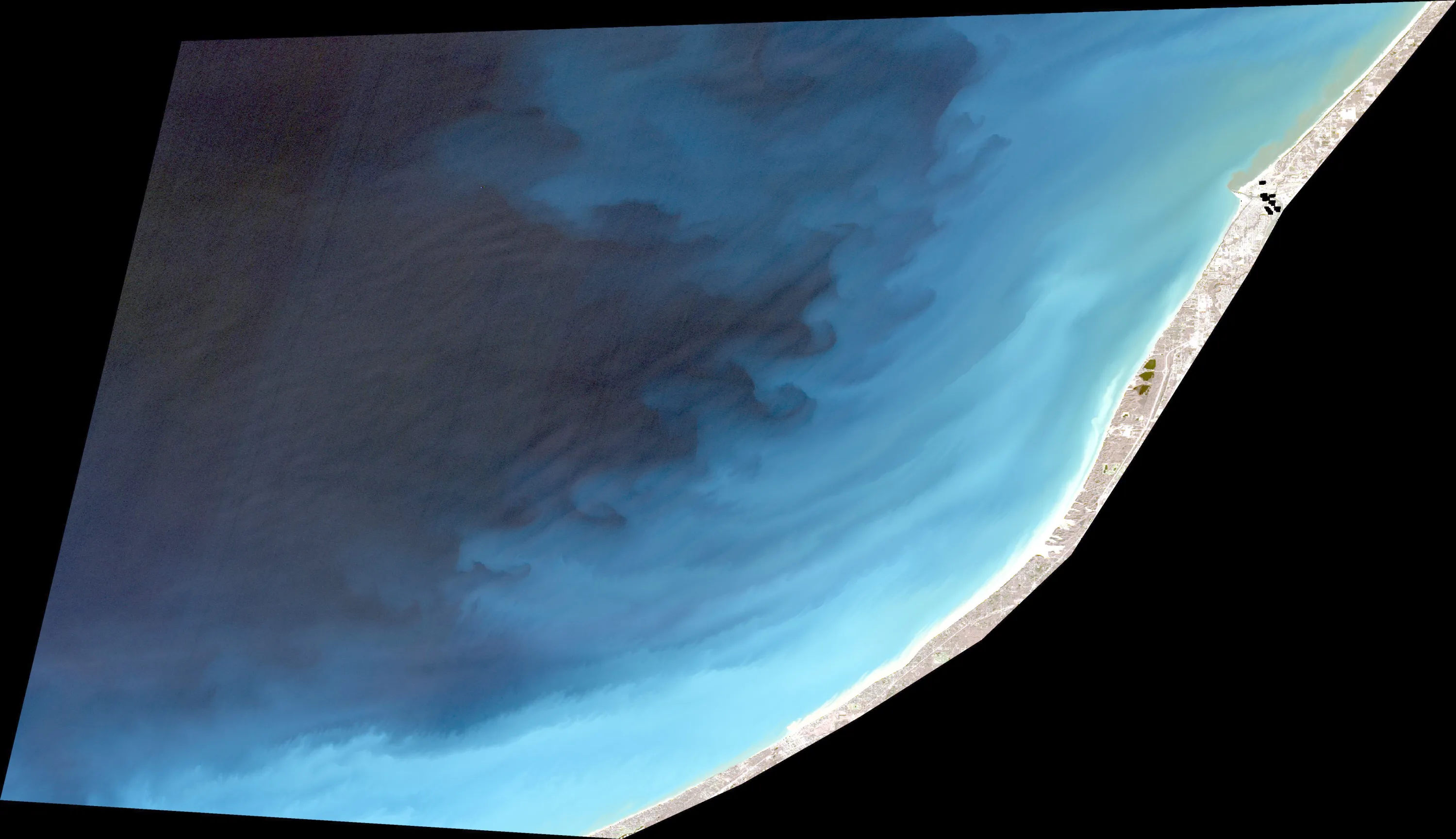
Analyze Satellite Imagery
This analysis focuses on the provided satellite imagery of the Lake Michigan shoreline near Berrien County. Given the current water temperature of 37°F, fish metabolism is extremely low, and the primary objective is locating areas that offer stability or slight thermal advantages.
1. LAKE OVERVIEW
The image captures a section of the open Lake Michigan coastline. Unlike an inland lake with coves and creeks, this is a linear, high-energy environment.
- Main Body: The vast, dark-blue area represents the deep, open water of Lake Michigan.
- Shoreline: A long, sandy beach transition zone characterized by light-blue, shallow water.
- Major Landmarks: The most significant visible feature is the pier/breakwall structure located at the top right of the image, which serves as the only major man-made obstruction to the natural current.
2. FINDABLE FISHING SPOTS
Note: In 37°F water, focus on the transition between the light-blue shallow water and the dark-blue deep water.
-
The Pier/Breakwall (Top Right):
- How to Find It: Navigate to the prominent man-made pier structure visible at the top right of the shoreline.
- What You See: A distinct, dark, linear structure extending into the water with a cluster of dark objects (likely buildings/docks) at the base.
- Why Fish It: This is the only significant "structure" in the image. It breaks the current and provides a hard-surface edge that fish use to orient themselves.
- Best Approach: Work the edges of the pier where the light-blue water meets the deeper, darker water.
-
The "First Drop" (Entire Shoreline):
- How to Find It: Anywhere along the beach, move out from the sand until the water color shifts from light blue to medium blue.
- What You See: A clear, sweeping color gradient running parallel to the entire beach.
- Why Fish It: This is the primary depth transition. In cold water, fish will often hold just off the break of the first sandbar.
- Best Approach: Trolling or slow-drifting parallel to the shoreline, keeping your boat positioned exactly on the color change line.
-
The "Deep-Water Edge" (Offshore):
- How to Find It: Move roughly 500–800 yards offshore from the beach until the water turns dark blue/black.
- What You See: The transition from the light-blue shelf to the deep-water basin.
- Why Fish It: This is the thermal refuge. When the shallows are 37°F, the deep water is more stable.
- Best Approach: Vertical jigging or slow-trolling deep-diving crankbaits that mimic baitfish.
3. VISIBLE FEATURES BY SECTION
- Shoreline/Beach Zone: A continuous, light-blue sandy shelf. This is the "shallow" zone. It is uniform, meaning fish will be scattered. Look for any slight irregularities in the sand color, which indicate minor humps or troughs.
- The Breakwall/Pier: The only significant structural feature. It creates a "corner" where the current is deflected.
- The Deep Basin: The dark-blue area on the left. This is the primary habitat for cold-water species during the early spring.
4. PRACTICAL FISHING GUIDANCE
- Start: Begin at the Pier/Breakwall. It is the most identifiable structure and the most likely place for fish to congregate in a featureless environment.
- Mid-Morning: If the pier is unproductive, move to the "First Drop" (the color transition line). Follow this line parallel to the beach for several miles.
- Pattern: Because the lake is so uniform, the "pattern" is entirely about depth control. If you find fish at a specific color transition, maintain that exact distance from the shore for the duration of the trip.
- Navigation: This is open water. Always keep the shoreline in sight. The pier is your primary navigation landmark for returning to the launch area.
PRIORITY TARGET RANKING:
- The Pier/Breakwall: 9/10 (High structure complexity, provides current break).
- The "First Drop" Color Line: 7/10 (Excellent for covering water, consistent depth).
- Deep Basin Edge: 6/10 (Good for thermal stability, but requires more searching).
WARNING: Lake Michigan is a massive, dangerous body of water. At 37°F, cold water immersion is life-threatening. Ensure your vessel is equipped for open-water conditions and monitor wind/wave forecasts closely, as there is no natural protection in this area.
Findings:
- This analysis focuses on the provided satellite imagery of the Lake Michigan shoreline near Berrien County. Given the current water temperature of 37°F, fish metabolism is extremely low, and the primary objective is locating areas that offer stability or slight thermal advantages.
1. LAKE OVERVIEW
The image captures a section of the open Lake Michigan coastline. Unlike an inland lake with coves and creeks, this is a linear, high-energy environment.
- Main Body: The vast, dark-blue area represents the deep, open water of Lake Michigan.
- Shoreline: A long, sandy beach transition zone characterized by light-blue, shallow water.
- Major Landmarks: The most significant visible feature is the pier/breakwall structure located at the top right of the image, which serves as the only major man-made obstruction to the natural current.
2. FINDABLE FISHING SPOTS
Note: In 37°F water, focus on the transition between the light-blue shallow water and the dark-blue deep water.
-
The Pier/Breakwall (Top Right):
- How to Find It: Navigate to the prominent man-made pier structure visible at the top right of the shoreline.
- What You See: A distinct, dark, linear structure extending into the water with a cluster of dark objects (likely buildings/docks) at the base.
- Why Fish It: This is the only significant "structure" in the image. It breaks the current and provides a hard-surface edge that fish use to orient themselves.
- Best Approach: Work the edges of the pier where the light-blue water meets the deeper, darker water.
-
The "First Drop" (Entire Shoreline):
- How to Find It: Anywhere along the beach, move out from the sand until the water color shifts from light blue to medium blue.
- What You See: A clear, sweeping color gradient running parallel to the entire beach.
- Why Fish It: This is the primary depth transition. In cold water, fish will often hold just off the break of the first sandbar.
- Best Approach: Trolling or slow-drifting parallel to the shoreline, keeping your boat positioned exactly on the color change line.
-
The "Deep-Water Edge" (Offshore):
- How to Find It: Move roughly 500–800 yards offshore from the beach until the water turns dark blue/black.
- What You See: The transition from the light-blue shelf to the deep-water basin.
- Why Fish It: This is the thermal refuge. When the shallows are 37°F, the deep water is more stable.
- Best Approach: Vertical jigging or slow-trolling deep-diving crankbaits that mimic baitfish.
3. VISIBLE FEATURES BY SECTION
- Shoreline/Beach Zone: A continuous, light-blue sandy shelf. This is the "shallow" zone. It is uniform, meaning fish will be scattered. Look for any slight irregularities in the sand color, which indicate minor humps or troughs.
- The Breakwall/Pier: The only significant structural feature. It creates a "corner" where the current is deflected.
- The Deep Basin: The dark-blue area on the left. This is the primary habitat for cold-water species during the early spring.
4. PRACTICAL FISHING GUIDANCE
- Start: Begin at the Pier/Breakwall. It is the most identifiable structure and the most likely place for fish to congregate in a featureless environment.
- Mid-Morning: If the pier is unproductive, move to the "First Drop" (the color transition line). Follow this line parallel to the beach for several miles.
- Pattern: Because the lake is so uniform, the "pattern" is entirely about depth control. If you find fish at a specific color transition, maintain that exact distance from the shore for the duration of the trip.
- Navigation: This is open water. Always keep the shoreline in sight. The pier is your primary navigation landmark for returning to the launch area.
PRIORITY TARGET RANKING:
- The Pier/Breakwall: 9/10 (High structure complexity, provides current break).
- The "First Drop" Color Line: 7/10 (Excellent for covering water, consistent depth).
- Deep Basin Edge: 6/10 (Good for thermal stability, but requires more searching).
WARNING: Lake Michigan is a massive, dangerous body of water. At 37°F, cold water immersion is life-threatening. Ensure your vessel is equipped for open-water conditions and monitor wind/wave forecasts closely, as there is no natural protection in this area.
How this was synthesized
Professional fishing guide analysis integrating 8 tools: lure_matrix_wind_clarity, estimate_seasonal_phase, analyze_weather_conditions, analyze_solunar_timing, analyze_species_behavior, analyze_thermal_patterns, analyze_water_clarity, analyze_satellite_imagery. User request: 'Generate a comprehensive fishing report for Lake Michigan. Use tools to analyze satellite structure, thermal patterns, water clarity, weather, and solunar timing, then synthesize a concise plan.'. Synthesis generated comprehensive plan with professional recommendations.