Mark Twain Lake Fishing Report
Synthesis generated comprehensive plan with professional recommendations.
Mark Twain Lake Fishing Report
Generated Mar 20, 2026, 12:43 PM.
Key fishing read
- Day 1: High pressure (1013mb) - tougher bite, use finesse tactics
- Day 1: High winds (25mph) - seek protected areas, use heavier lures
- Day 1: MostlyClear, High: 80°F, Low: 49°F
- Day 2: High pressure (1010mb) - tougher bite, use finesse tactics
- Day 2: High winds (22mph) - seek protected areas, use heavier lures
- Day 2: Clear, High: 84°F, Low: 51°F
- Day 3: High pressure (1011mb) - tougher bite, use finesse tactics
- Day 3: High winds (53mph) - seek protected areas, use heavier lures
Tool analysis details
Analyze Weather Conditions
Weather analysis for Mark Twain Lake completed
Findings:
- Day 1: High pressure (1013mb) - tougher bite, use finesse tactics
- Day 1: High winds (25mph) - seek protected areas, use heavier lures
- Day 1: MostlyClear, High: 80°F, Low: 49°F
- Day 2: High pressure (1010mb) - tougher bite, use finesse tactics
- Day 2: High winds (22mph) - seek protected areas, use heavier lures
Analyze Pressure Trends
Barometric pressure analysis for Mark Twain Lake: rising trend at 1013.00mb
Findings:
- Rising pressure trend (1013.00 → higher). Bite may slow down as fish become less active.
- Switch to finesse tactics, target deeper structure. Fish will be less aggressive.
Analyze Solunar Timing
Solunar timing analysis for Mark Twain Lake completed
Findings:
- 2026-03-20 Major feeding periods: 02:04 PM - 04:34 PM, 12:00 AM - 12:00 AM
- 2026-03-20 Minor feeding periods: 07:16 AM - 08:46 AM, 09:07 PM - 10:37 PM
- 2026-03-21 Major feeding periods: 02:57 PM - 05:27 PM, 02:15 AM - 04:45 AM
- 2026-03-21 Minor feeding periods: 07:45 AM - 09:15 AM, 10:24 PM - 11:54 PM
- 2026-03-22 Major feeding periods: 03:54 PM - 06:24 PM, 03:10 AM - 05:40 AM
Analyze Thermal Patterns
This analysis is based on the provided thermal satellite image of the lake.
1. Overall Thermal Landscape Summary
- Assumed Orientation: North is at the top of the image.
- Major Visual Anchors:
- The Western Arm: A complex, multi-fingered section on the left side of the image.
- The Central Basin: The main, elongated body of water connecting the western arms to the eastern section.
- The Eastern Reach: The narrow, winding section extending toward the top right.
- Dominant Temperatures: The lake is dominated by Dark Blue (42-46°F / 6-8°C), indicating late winter/early spring conditions.
- Temperature Range: Visible surface temperatures range from approximately 44°F (Dark Blue) in the central basin to 56°F (Light Blue/Cyan) in the far western extremities.
2. Detailed Thermal Feature Analysis
- Temperature Breaks: The most significant thermal break occurs in the far western arm. There is a distinct transition from the Dark Blue (42-46°F) of the main body into a Light Blue/Cyan (52-60°F) zone at the westernmost tip. This represents a 10-14°F gradient over a relatively short distance.
- Pockets/Patches: A smaller, isolated warming trend is visible in the southernmost finger of the western arm, where the color shifts from Dark Blue to a lighter shade, indicating a localized warming pocket.
- Gradients: A gradual warming gradient is visible moving from the center of the lake toward the western and northern extremities. The water becomes progressively lighter in color as you move away from the central basin.
- Uniform Areas: The central basin and the eastern reach exhibit high thermal uniformity, appearing almost entirely in the Dark Blue (42-46°F) range. This suggests these areas are currently stable and cold.
3. Insightful Fish Behavior Interpretation
- General Behavior: Given the dominant Dark Blue (42-46°F) temperatures, fish across the majority of the lake are likely in a "late winter" state—lethargic, holding tight to structure, and exhibiting very slow metabolism.
- Activity Zones: The western arm is the only area showing significant thermal activity. The transition to Light Blue/Cyan (52-60°F) indicates that fish in this specific area are likely transitioning into pre-spawn or early spring activity. They will be more responsive to lures and more likely to move toward shallower water to feed compared to the sluggish populations in the central basin.
4. Satellite Correlation Analysis
- Inflow/Outflow: The warming observed in the western extremities often correlates with shallow creek inlets or protected coves that absorb solar radiation faster than the deeper, open-water central basin.
- Wind-Mixing: The uniformity of the central basin suggests that wind-driven mixing is keeping the surface temperatures consistent, preventing the formation of warmer surface layers in the main body.
5. Actionable Fishing Recommendations
- Target the Western Arm: Focus your efforts exclusively on the westernmost finger where the water color shifts to Light Blue/Cyan (52-60°F). This is the only area where fish are likely to be active enough to feed aggressively.
- Slow Down in the Center: If you must fish the central basin or eastern reach (Dark Blue, 42-46°F), use extremely slow presentations. Fish here are in a "winter" mindset; expect very light bites and long periods between strikes.
- Work the Thermal Break: The transition zone in the western arm—where the water shifts from Dark Blue to Light Blue—is your "prime" target. Fish the edges of this color change, as active fish will often stage along the boundary between the cold main-lake water and the warmer, more productive water of the inlet.
- Tactical Approach: In the warmer western pockets, use smaller, subtle baits that mimic early-season forage. In the colder central areas, focus on vertical presentations near any visible structure, as fish will be conserving energy.
Findings:
- Current surface temperature: 35.0°F. Fish metabolism significantly reduced in cold water. Target sunny, protected shorelines and use extremely slow presentations. Focus on midday when surface temperatures are warmest.
- This analysis is based on the provided thermal satellite image of the lake.
1. Overall Thermal Landscape Summary
- Assumed Orientation: North is at the top of the image.
- Major Visual Anchors:
- The Western Arm: A complex, multi-fingered section on the left side of the image.
- The Central Basin: The main, elongated body of water connecting the western arms to the eastern section.
- The Eastern Reach: The narrow, winding section extending toward the top right.
- Dominant Temperatures: The lake is dominated by Dark Blue (42-46°F / 6-8°C), indicating late winter/early spring conditions.
- Temperature Range: Visible surface temperatures range from approximately 44°F (Dark Blue) in the central basin to 56°F (Light Blue/Cyan) in the far western extremities.
2. Detailed Thermal Feature Analysis
- Temperature Breaks: The most significant thermal break occurs in the far western arm. There is a distinct transition from the Dark Blue (42-46°F) of the main body into a Light Blue/Cyan (52-60°F) zone at the westernmost tip. This represents a 10-14°F gradient over a relatively short distance.
- Pockets/Patches: A smaller, isolated warming trend is visible in the southernmost finger of the western arm, where the color shifts from Dark Blue to a lighter shade, indicating a localized warming pocket.
- Gradients: A gradual warming gradient is visible moving from the center of the lake toward the western and northern extremities. The water becomes progressively lighter in color as you move away from the central basin.
- Uniform Areas: The central basin and the eastern reach exhibit high thermal uniformity, appearing almost entirely in the Dark Blue (42-46°F) range. This suggests these areas are currently stable and cold.
3. Insightful Fish Behavior Interpretation
- General Behavior: Given the dominant Dark Blue (42-46°F) temperatures, fish across the majority of the lake are likely in a "late winter" state—lethargic, holding tight to structure, and exhibiting very slow metabolism.
- Activity Zones: The western arm is the only area showing significant thermal activity. The transition to Light Blue/Cyan (52-60°F) indicates that fish in this specific area are likely transitioning into pre-spawn or early spring activity. They will be more responsive to lures and more likely to move toward shallower water to feed compared to the sluggish populations in the central basin.
4. Satellite Correlation Analysis
- Inflow/Outflow: The warming observed in the western extremities often correlates with shallow creek inlets or protected coves that absorb solar radiation faster than the deeper, open-water central basin.
- Wind-Mixing: The uniformity of the central basin suggests that wind-driven mixing is keeping the surface temperatures consistent, preventing the formation of warmer surface layers in the main body.
5. Actionable Fishing Recommendations
- Target the Western Arm: Focus your efforts exclusively on the westernmost finger where the water color shifts to Light Blue/Cyan (52-60°F). This is the only area where fish are likely to be active enough to feed aggressively.
- Slow Down in the Center: If you must fish the central basin or eastern reach (Dark Blue, 42-46°F), use extremely slow presentations. Fish here are in a "winter" mindset; expect very light bites and long periods between strikes.
- Work the Thermal Break: The transition zone in the western arm—where the water shifts from Dark Blue to Light Blue—is your "prime" target. Fish the edges of this color change, as active fish will often stage along the boundary between the cold main-lake water and the warmer, more productive water of the inlet.
- Tactical Approach: In the warmer western pockets, use smaller, subtle baits that mimic early-season forage. In the colder central areas, focus on vertical presentations near any visible structure, as fish will be conserving energy.
- Spring warming: Focus on shallow bays and areas showing the warmest surface temperatures in thermal imagery as fish move into spawning areas.
Analyze Satellite Imagery
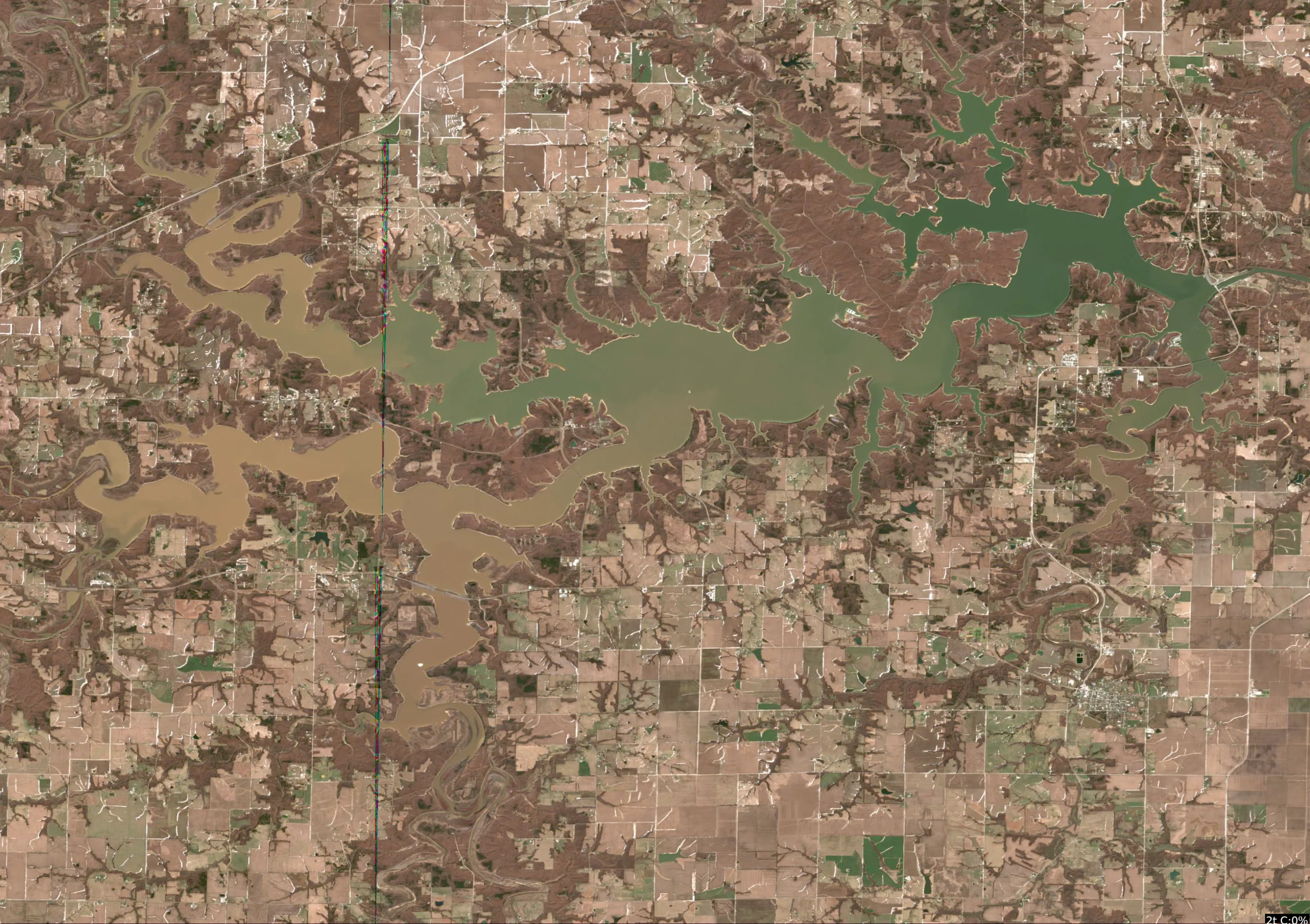
This analysis focuses on the visible features of Mark Twain Lake as presented in the provided satellite imagery. Given the current water temperature of 35°F, the fish are in a winter/pre-spawn holding pattern, meaning they will be tightly grouped near structural transitions and deeper water.
1. LAKE OVERVIEW
Mark Twain Lake is a sprawling, dendritic reservoir characterized by a distinct "main lake" body and several long, winding creek arms.
- Main Lake Body: The central, wider section of the lake, characterized by deeper, clearer water (darker green/blue tones).
- Creek Arms: The long, serpentine branches extending from the main body. These are currently showing significant sediment/turbidity (tan/brown color), indicating runoff or shallow, muddy conditions.
- Major Landmarks: The lake is defined by its complex shoreline with numerous points and coves. The transition from the muddy, shallow creek arms to the clearer main lake is the most critical feature for an angler to identify.
2. FINDABLE FISHING SPOTS
-
Main Lake - The Primary Point:
- How to Find: Locate the main body of the lake where the water transitions from tan to a deeper green. Look for the large, prominent point extending into the center of the main basin.
- What You See: A sharp, well-defined point with deep water immediately adjacent to the tip.
- Why Fish It: In 35°F water, fish will hold on the first deep-water structure they encounter when moving out of the creek arms.
- Best Approach: Use a vertical presentation (jigging spoon or blade bait) off the tip of the point.
-
Main Lake - The "Narrows" Transition:
- How to Find: Find the area where the main lake begins to constrict before opening into the larger basin.
- What You See: A bottleneck where the shoreline geometry creates a natural funnel.
- Why Fish It: This acts as a highway for fish moving between the upper creek arms and the main lake.
- Best Approach: Slow-rolling a heavy swimbait or dragging a football jig along the bottom.
-
Creek Arm - The First Major Bend:
- How to Find: Enter the southern creek arm; look for the first sharp "S" curve in the channel.
- What You See: A distinct change in the shoreline where the channel swings close to the bank.
- Why Fish It: The outside bend of a channel provides the deepest water in the immediate area.
- Best Approach: Target the outside bank with a suspending jerkbait, pausing for long periods to account for the cold water.
-
Main Lake - The Protected Cove Mouth:
- How to Find: On the northern shore of the main lake, identify the mouth of a secondary cove.
- What You See: A small, recessed area with a distinct "mouth" where it meets the main lake.
- Why Fish It: The mouth of a cove offers a transition from deep main-lake water to shallower, protected water.
- Best Approach: Focus on the points at the mouth of the cove; fish will stage here before moving into the cove as the water warms.
-
Creek Arm - The Channel Junction:
- How to Find: In the western arm, locate where two smaller creek channels converge.
- What You See: A "Y" intersection in the dark, serpentine channel lines.
- Why Fish It: Junctions are high-percentage areas for baitfish to congregate, which will draw in predators.
- Best Approach: A drop-shot rig worked slowly through the intersection.
3. VISIBLE FEATURES BY SECTION
- Main Lake Body:
- Major Points: Several large, sweeping points that extend into the deep basin. These are the highest priority for winter fishing.
- Deep Water: The dark green color indicates the deepest water in the system; focus here for the most stable temperatures.
- Creek Arms (Western/Southern):
- Channel Bends: Clearly visible as dark, winding lines. These are the "roads" fish use to travel.
- Sediment Lines: The tan water indicates high turbidity; avoid the very back of these arms where the water is likely too cold and muddy.
4. PRACTICAL FISHING GUIDANCE
- Progression:
- Start: Begin at the Main Lake Primary Point. The water is most stable here, and the deep-water access is immediate.
- Mid-Morning: Move to the Narrows Transition. As the sun hits the water, fish may move slightly shallower along these funnel points.
- Afternoon: If the bite is slow, move into the Creek Arm Channel Bends. The slightly shallower water may warm up by a degree or two, which can trigger a brief feeding window.
- Navigation: When moving from the creek arms to the main lake, stay in the center of the channel. The transition from tan to green water is your visual cue that you are moving from "traveling" water to "holding" water. Always keep an eye on your sonar for depth changes as you approach the points identified above.
Findings:
- This analysis focuses on the visible features of Mark Twain Lake as presented in the provided satellite imagery. Given the current water temperature of 35°F, the fish are in a winter/pre-spawn holding pattern, meaning they will be tightly grouped near structural transitions and deeper water.
1. LAKE OVERVIEW
Mark Twain Lake is a sprawling, dendritic reservoir characterized by a distinct "main lake" body and several long, winding creek arms.
- Main Lake Body: The central, wider section of the lake, characterized by deeper, clearer water (darker green/blue tones).
- Creek Arms: The long, serpentine branches extending from the main body. These are currently showing significant sediment/turbidity (tan/brown color), indicating runoff or shallow, muddy conditions.
- Major Landmarks: The lake is defined by its complex shoreline with numerous points and coves. The transition from the muddy, shallow creek arms to the clearer main lake is the most critical feature for an angler to identify.
2. FINDABLE FISHING SPOTS
-
Main Lake - The Primary Point:
- How to Find: Locate the main body of the lake where the water transitions from tan to a deeper green. Look for the large, prominent point extending into the center of the main basin.
- What You See: A sharp, well-defined point with deep water immediately adjacent to the tip.
- Why Fish It: In 35°F water, fish will hold on the first deep-water structure they encounter when moving out of the creek arms.
- Best Approach: Use a vertical presentation (jigging spoon or blade bait) off the tip of the point.
-
Main Lake - The "Narrows" Transition:
- How to Find: Find the area where the main lake begins to constrict before opening into the larger basin.
- What You See: A bottleneck where the shoreline geometry creates a natural funnel.
- Why Fish It: This acts as a highway for fish moving between the upper creek arms and the main lake.
- Best Approach: Slow-rolling a heavy swimbait or dragging a football jig along the bottom.
-
Creek Arm - The First Major Bend:
- How to Find: Enter the southern creek arm; look for the first sharp "S" curve in the channel.
- What You See: A distinct change in the shoreline where the channel swings close to the bank.
- Why Fish It: The outside bend of a channel provides the deepest water in the immediate area.
- Best Approach: Target the outside bank with a suspending jerkbait, pausing for long periods to account for the cold water.
-
Main Lake - The Protected Cove Mouth:
- How to Find: On the northern shore of the main lake, identify the mouth of a secondary cove.
- What You See: A small, recessed area with a distinct "mouth" where it meets the main lake.
- Why Fish It: The mouth of a cove offers a transition from deep main-lake water to shallower, protected water.
- Best Approach: Focus on the points at the mouth of the cove; fish will stage here before moving into the cove as the water warms.
-
Creek Arm - The Channel Junction:
- How to Find: In the western arm, locate where two smaller creek channels converge.
- What You See: A "Y" intersection in the dark, serpentine channel lines.
- Why Fish It: Junctions are high-percentage areas for baitfish to congregate, which will draw in predators.
- Best Approach: A drop-shot rig worked slowly through the intersection.
3. VISIBLE FEATURES BY SECTION
- Main Lake Body:
- Major Points: Several large, sweeping points that extend into the deep basin. These are the highest priority for winter fishing.
- Deep Water: The dark green color indicates the deepest water in the system; focus here for the most stable temperatures.
- Creek Arms (Western/Southern):
- Channel Bends: Clearly visible as dark, winding lines. These are the "roads" fish use to travel.
- Sediment Lines: The tan water indicates high turbidity; avoid the very back of these arms where the water is likely too cold and muddy.
4. PRACTICAL FISHING GUIDANCE
- Progression:
- Start: Begin at the Main Lake Primary Point. The water is most stable here, and the deep-water access is immediate.
- Mid-Morning: Move to the Narrows Transition. As the sun hits the water, fish may move slightly shallower along these funnel points.
- Afternoon: If the bite is slow, move into the Creek Arm Channel Bends. The slightly shallower water may warm up by a degree or two, which can trigger a brief feeding window.
- Navigation: When moving from the creek arms to the main lake, stay in the center of the channel. The transition from tan to green water is your visual cue that you are moving from "traveling" water to "holding" water. Always keep an eye on your sonar for depth changes as you approach the points identified above.
Analyze Water Clarity
This analysis of Mark Twain Lake is based on the provided multi-spectral imagery, interpreting the Chlorophyll (MCI) and Suspended Solids (TSS) indicators to guide tactical angling decisions.
1. Overall Water Quality Summary
The lake exhibits a clear gradient of productivity and turbidity. The main basin and primary channels are characterized by moderate chlorophyll levels (Green) with low sediment, indicating stable, productive water. Conversely, the southern and western tributary arms show significantly higher concentrations of both chlorophyll and suspended solids (Red/Orange/Brown), indicating high-nutrient, turbid inflow zones.
2. Detailed Clarity Zone Mapping & Characterization
| Zone | Matrix Position | Visual Characteristics | Visibility |
|---|---|---|---|
| Main Basin | Bottom-Center | Green (Moderate Chlorophyll, Low Sediment) | 8–15 ft |
| Mid-Lake Channels | Bottom-Right | Yellow-Green (High Chlorophyll, Low Sediment) | 3–8 ft |
| Southern/Western Arms | Top-Right | Red/Brown (High Chlorophyll, High Sediment) | < 2 ft |
- Main Basin (Central/Eastern): Represents the most stable water. The moderate chlorophyll levels suggest a healthy ecosystem without the interference of heavy runoff.
- Southern/Western Tributary Arms: These are high-activity zones. The "Red/Brown" signature indicates these areas are receiving significant nutrient and sediment loading, likely from recent runoff or shallow-water agitation.
3. Turbidity/Algae Sources & Transition Zones
- Sources: The southern and western extremities are the primary sources of turbidity. The high-contrast "Red/Brown" signatures suggest these are the points of entry for watershed runoff.
- Transition Zones: The most critical fishing areas are the "Clarity Breaks"—the lines where the Green (Main Basin) meets the Yellow/Red (Tributary Arms). These edges act as natural ambush points where baitfish congregate to feed on plankton, and predators (Bass/Walleye) stage to hunt.
4. Species-Specific Clarity Strategy
- Bass: Target the Transition Zones (where Green meets Yellow). Use the clearer water to locate structure and the stained water to trigger reaction strikes.
- Walleye: Focus on the Main Basin (Green Zone). They prefer the moderate visibility and stable conditions found in the deeper, open-water sections of the lake.
- Crappie: Target the Yellow-Green zones in the mid-lake channels. They will likely be suspended near the edges of these zones, utilizing the slight stain for cover.
5. Tactical Fishing Adjustments
- Main Basin (Green Zone):
- Lures: Natural shad-colored jerkbaits, green pumpkin jigs, or finesse swimbaits.
- Retrieve: Slow to moderate, focusing on natural presentation.
- Transition Zones (Green/Yellow Edge):
- Lures: Chatterbaits (white/chartreuse) or spinnerbaits.
- Retrieve: Aggressive, fast-paced retrieves to trigger reaction strikes from fish holding on the edge.
- Southern/Western Arms (Red/Brown Zone):
- Lures: Large profile baits with heavy rattles (e.g., 1/2 oz black/blue jigs, loud lipless crankbaits).
- Retrieve: Slow, methodical, and close to cover. Sound and vibration are your primary tools here.
6. Seasonal Context
The presence of high chlorophyll (Red/Yellow) in the tributary arms, contrasted with the stable Green of the main basin, is consistent with early-to-mid spring conditions. The high sediment in the southern arms suggests recent rainfall or snowmelt runoff entering the system. The main basin’s resilience (maintaining a Green status) indicates that the lake is currently in a productive, pre-spawn or early-spawn phase where fish are likely moving from the deeper main basin toward the warmer, nutrient-rich tributary arms.
Pro-Tip: Given the current water temperature of 35°F, prioritize the Main Basin (Green Zone). Even though the tributary arms are nutrient-rich, the cold water will make fish sluggish. Focus on the deepest, most stable water where the temperature is less likely to fluctuate, and downsize your bait profile by 25% to account for the lethargic metabolism of the fish.
Findings:
- This analysis of Mark Twain Lake is based on the provided multi-spectral imagery, interpreting the Chlorophyll (MCI) and Suspended Solids (TSS) indicators to guide tactical angling decisions.
1. Overall Water Quality Summary
The lake exhibits a clear gradient of productivity and turbidity. The main basin and primary channels are characterized by moderate chlorophyll levels (Green) with low sediment, indicating stable, productive water. Conversely, the southern and western tributary arms show significantly higher concentrations of both chlorophyll and suspended solids (Red/Orange/Brown), indicating high-nutrient, turbid inflow zones.
2. Detailed Clarity Zone Mapping & Characterization
| Zone | Matrix Position | Visual Characteristics | Visibility |
|---|---|---|---|
| Main Basin | Bottom-Center | Green (Moderate Chlorophyll, Low Sediment) | 8–15 ft |
| Mid-Lake Channels | Bottom-Right | Yellow-Green (High Chlorophyll, Low Sediment) | 3–8 ft |
| Southern/Western Arms | Top-Right | Red/Brown (High Chlorophyll, High Sediment) | < 2 ft |
- Main Basin (Central/Eastern): Represents the most stable water. The moderate chlorophyll levels suggest a healthy ecosystem without the interference of heavy runoff.
- Southern/Western Tributary Arms: These are high-activity zones. The "Red/Brown" signature indicates these areas are receiving significant nutrient and sediment loading, likely from recent runoff or shallow-water agitation.
3. Turbidity/Algae Sources & Transition Zones
- Sources: The southern and western extremities are the primary sources of turbidity. The high-contrast "Red/Brown" signatures suggest these are the points of entry for watershed runoff.
- Transition Zones: The most critical fishing areas are the "Clarity Breaks"—the lines where the Green (Main Basin) meets the Yellow/Red (Tributary Arms). These edges act as natural ambush points where baitfish congregate to feed on plankton, and predators (Bass/Walleye) stage to hunt.
4. Species-Specific Clarity Strategy
- Bass: Target the Transition Zones (where Green meets Yellow). Use the clearer water to locate structure and the stained water to trigger reaction strikes.
- Walleye: Focus on the Main Basin (Green Zone). They prefer the moderate visibility and stable conditions found in the deeper, open-water sections of the lake.
- Crappie: Target the Yellow-Green zones in the mid-lake channels. They will likely be suspended near the edges of these zones, utilizing the slight stain for cover.
5. Tactical Fishing Adjustments
- Main Basin (Green Zone):
- Lures: Natural shad-colored jerkbaits, green pumpkin jigs, or finesse swimbaits.
- Retrieve: Slow to moderate, focusing on natural presentation.
- Transition Zones (Green/Yellow Edge):
- Lures: Chatterbaits (white/chartreuse) or spinnerbaits.
- Retrieve: Aggressive, fast-paced retrieves to trigger reaction strikes from fish holding on the edge.
- Southern/Western Arms (Red/Brown Zone):
- Lures: Large profile baits with heavy rattles (e.g., 1/2 oz black/blue jigs, loud lipless crankbaits).
- Retrieve: Slow, methodical, and close to cover. Sound and vibration are your primary tools here.
6. Seasonal Context
The presence of high chlorophyll (Red/Yellow) in the tributary arms, contrasted with the stable Green of the main basin, is consistent with early-to-mid spring conditions. The high sediment in the southern arms suggests recent rainfall or snowmelt runoff entering the system. The main basin’s resilience (maintaining a Green status) indicates that the lake is currently in a productive, pre-spawn or early-spawn phase where fish are likely moving from the deeper main basin toward the warmer, nutrient-rich tributary arms.
Pro-Tip: Given the current water temperature of 35°F, prioritize the Main Basin (Green Zone). Even though the tributary arms are nutrient-rich, the cold water will make fish sluggish. Focus on the deepest, most stable water where the temperature is less likely to fluctuate, and downsize your bait profile by 25% to account for the lethargic metabolism of the fish.
How this was synthesized
Professional fishing guide analysis integrating 6 tools: analyze_weather_conditions, analyze_pressure_trends, analyze_solunar_timing, analyze_thermal_patterns, analyze_satellite_imagery, analyze_water_clarity. User request: 'Analyze the water clarity for Mark Twain Lake. Identify clear vs. murky areas and suggest fishing strategies based on clarity conditions.'. Synthesis generated comprehensive plan with professional recommendations.