Blewett Falls Lake Fishing Report
Synthesis generated comprehensive plan with professional recommendations.
Blewett Falls Lake Fishing Report
Generated Mar 25, 2026, 2:26 PM.
Key fishing read
- Day 1: High pressure (1026mb) - tougher bite, use finesse tactics
- Day 1: Moderate wind (10mph) - ideal conditions, target windblown points
- Day 1: PartlyCloudy, High: 67°F, Low: 34°F
- Day 2: High pressure (1020mb) - tougher bite, use finesse tactics
- Day 2: High winds (25mph) - seek protected areas, use heavier lures
- Day 2: PartlyCloudy, High: 78°F, Low: 51°F
- Day 3: High pressure (1015mb) - tougher bite, use finesse tactics
- Day 3: High winds (32mph) - seek protected areas, use heavier lures
Tool analysis details
Analyze Weather Conditions
Weather analysis for Blewett Falls Lake completed
Findings:
- Day 1: High pressure (1026mb) - tougher bite, use finesse tactics
- Day 1: Moderate wind (10mph) - ideal conditions, target windblown points
- Day 1: PartlyCloudy, High: 67°F, Low: 34°F
- Day 2: High pressure (1020mb) - tougher bite, use finesse tactics
- Day 2: High winds (25mph) - seek protected areas, use heavier lures
Lure Matrix Wind Clarity
Lure guidance for wind=moderate, clarity=unknown, phase=fall.
Findings:
- Loud/bright: chartreuse/black, Colorado blades, big profile cranks
- Fall: chase baitfish in creeks; spinnerbaits/lipless cranks to cover water
Estimate Seasonal Phase
Season estimate for Blewett Falls Lake: fall.
Findings:
- Estimated phase: fall
- Temp change over window: -21.7°F
Analyze Solunar Timing
Solunar timing analysis for Blewett Falls Lake completed
Findings:
- 2026-03-25 Major feeding periods: 07:10 PM - 09:40 PM, 08:03 AM - 10:33 AM
- 2026-03-25 Minor feeding periods: 11:24 AM - 12:54 PM, 01:56 AM - 03:26 AM
- 2026-03-26 Major feeding periods: 08:10 PM - 10:40 PM, 09:05 AM - 11:35 AM
- 2026-03-26 Minor feeding periods: 12:32 PM - 02:02 PM, 02:53 AM - 04:23 AM
- 2026-03-27 Major feeding periods: 09:05 PM - 11:35 PM, 10:02 AM - 12:32 PM
Analyze Species Behavior
Species behavior analysis for Blewett Falls Lake completed
Analyze Thermal Patterns
1. Overall Thermal Landscape Summary
- Assumed Orientation: North is at the top of the image.
- Major Visual Anchors:
- The Northern Arm: A long, narrow, linear section extending toward the top.
- The Central Basin: The wider, bulbous section in the middle of the lake.
- The Southern Pool: The rounded, wider basin at the bottom, containing a distinct central island.
- Thermal Summary: The lake exhibits a clear thermal gradient, warming as you move from the northern tip toward the southern pool. Temperatures range from approximately 55°F (13°C) in the northern reaches to 62°F (17°C) in the southern basin. The dominant colors are Cyan/Light Teal (56-60°F) and Light Green (60-64°F), indicating a spring-like transition period.
2. Detailed Thermal Feature Analysis
- Temperature Breaks:
- A significant thermal break exists at the transition between the narrow Northern Arm and the wider Central Basin. The water shifts from the cooler Cyan (56-58°F) to the warmer Yellow-Green/Light Green (60-62°F).
- Another notable break occurs around the island in the Southern Pool, where the water immediately surrounding the island is slightly cooler than the surrounding open water in the basin.
- Pockets/Patches:
- The warmest water is concentrated in the center of the Southern Pool, specifically in the area between the island and the eastern shoreline, showing consistent Light Green (60-62°F) signatures.
- Gradients:
- There is a steady, gradual warming gradient moving from the top-most northern tip down through the central channel. This suggests a slow transition rather than abrupt inflow-driven changes.
- Uniform Areas:
- The Northern Arm is relatively uniform in its Cyan/Light Teal coloring (56-58°F), suggesting stable, cooler conditions throughout that stretch.
3. Insightful Fish Behavior Interpretation
- Northern Arm (55-58°F): Fish here are in a pre-spawn staging phase. Activity is increasing, but they will likely be holding tighter to cover and moving more slowly than in the southern sections.
- Central Basin & Southern Pool (60-62°F): This is the "Optimal Spring" zone. Fish in these areas are likely in an active feeding mode. The warmer water in the Southern Pool will likely hold the most aggressive fish, as they are closer to the peak activity range (60-64°F).
- Island Influence: The cooler water surrounding the island in the Southern Pool may act as a "thermal refuge" if the surrounding basin becomes too warm, or conversely, as a staging point for fish moving between deeper and shallower water.
4. Satellite Correlation Analysis
- Inflow/Outflow: The northernmost tip shows the coolest temperatures (55°F), which is consistent with a potential river or creek inflow entering the lake from the north.
- Structure-Surface Relationships: The island in the Southern Pool creates a distinct thermal signature. The water immediately adjacent to the island is cooler, likely due to the island's mass and potential shading or depth variations near the shoreline, creating a micro-climate that differs from the open basin.
5. Actionable Fishing Recommendations
- Target the Southern Pool: Focus your efforts in the Southern Pool, specifically the area between the island and the eastern shoreline. The Light Green (60-62°F) water here is in the optimal range for active, aggressive feeding.
- Work the Thermal Break: The transition zone where the Northern Arm meets the Central Basin is a high-percentage area. Fish the "edge" where the water temperature shifts from 58°F to 60°F; this is a classic location for fish to stage as they move between cooler and warmer zones.
- Island Perimeter: Use the island in the Southern Pool as a primary target. The thermal break between the cooler water immediately surrounding the island and the warmer basin water provides an excellent ambush point for predatory fish.
- Strategy: Start in the Southern Pool with more aggressive, moving baits (crankbaits or spinnerbaits) to capitalize on the 60-62°F water. If the bite is slow, move toward the Northern Arm and slow down your presentation, focusing on the 56-58°F water with jigs or soft plastics.
Findings:
- Current surface temperature: 51.0°F. Fish showing moderate activity levels. Target temperature transition zones where warmer water meets cooler areas, often near inflows or wind-protected bays.
- Bass spawn timing: Estimated 12 days until pre-spawn staging begins (need ~55°F) | Early mayfly hatches likely beginning - Blue-Winged Olives and Hendricksons (Timing adjusted 15 days later due to elevation 0ft and latitude 45.0°N)
-
1. Overall Thermal Landscape Summary
- Assumed Orientation: North is at the top of the image.
- Major Visual Anchors:
- The Northern Arm: A long, narrow, linear section extending toward the top.
- The Central Basin: The wider, bulbous section in the middle of the lake.
- The Southern Pool: The rounded, wider basin at the bottom, containing a distinct central island.
- Thermal Summary: The lake exhibits a clear thermal gradient, warming as you move from the northern tip toward the southern pool. Temperatures range from approximately 55°F (13°C) in the northern reaches to 62°F (17°C) in the southern basin. The dominant colors are Cyan/Light Teal (56-60°F) and Light Green (60-64°F), indicating a spring-like transition period.
2. Detailed Thermal Feature Analysis
- Temperature Breaks:
- A significant thermal break exists at the transition between the narrow Northern Arm and the wider Central Basin. The water shifts from the cooler Cyan (56-58°F) to the warmer Yellow-Green/Light Green (60-62°F).
- Another notable break occurs around the island in the Southern Pool, where the water immediately surrounding the island is slightly cooler than the surrounding open water in the basin.
- Pockets/Patches:
- The warmest water is concentrated in the center of the Southern Pool, specifically in the area between the island and the eastern shoreline, showing consistent Light Green (60-62°F) signatures.
- Gradients:
- There is a steady, gradual warming gradient moving from the top-most northern tip down through the central channel. This suggests a slow transition rather than abrupt inflow-driven changes.
- Uniform Areas:
- The Northern Arm is relatively uniform in its Cyan/Light Teal coloring (56-58°F), suggesting stable, cooler conditions throughout that stretch.
3. Insightful Fish Behavior Interpretation
- Northern Arm (55-58°F): Fish here are in a pre-spawn staging phase. Activity is increasing, but they will likely be holding tighter to cover and moving more slowly than in the southern sections.
- Central Basin & Southern Pool (60-62°F): This is the "Optimal Spring" zone. Fish in these areas are likely in an active feeding mode. The warmer water in the Southern Pool will likely hold the most aggressive fish, as they are closer to the peak activity range (60-64°F).
- Island Influence: The cooler water surrounding the island in the Southern Pool may act as a "thermal refuge" if the surrounding basin becomes too warm, or conversely, as a staging point for fish moving between deeper and shallower water.
4. Satellite Correlation Analysis
- Inflow/Outflow: The northernmost tip shows the coolest temperatures (55°F), which is consistent with a potential river or creek inflow entering the lake from the north.
- Structure-Surface Relationships: The island in the Southern Pool creates a distinct thermal signature. The water immediately adjacent to the island is cooler, likely due to the island's mass and potential shading or depth variations near the shoreline, creating a micro-climate that differs from the open basin.
5. Actionable Fishing Recommendations
- Target the Southern Pool: Focus your efforts in the Southern Pool, specifically the area between the island and the eastern shoreline. The Light Green (60-62°F) water here is in the optimal range for active, aggressive feeding.
- Work the Thermal Break: The transition zone where the Northern Arm meets the Central Basin is a high-percentage area. Fish the "edge" where the water temperature shifts from 58°F to 60°F; this is a classic location for fish to stage as they move between cooler and warmer zones.
- Island Perimeter: Use the island in the Southern Pool as a primary target. The thermal break between the cooler water immediately surrounding the island and the warmer basin water provides an excellent ambush point for predatory fish.
- Strategy: Start in the Southern Pool with more aggressive, moving baits (crankbaits or spinnerbaits) to capitalize on the 60-62°F water. If the bite is slow, move toward the Northern Arm and slow down your presentation, focusing on the 56-58°F water with jigs or soft plastics.
- Spring warming: Focus on shallow bays and areas showing the warmest surface temperatures in thermal imagery as fish move into spawning areas.
Analyze Water Clarity
This analysis of Blewett Falls Lake is based on the provided multi-spectral imagery, which highlights distinct gradients in Chlorophyll (MCI) and Suspended Solids (TSS).
1. Overall Water Quality Summary
The imagery reveals a classic reservoir "river-to-basin" gradient. The northern, riverine section exhibits high biological productivity (high chlorophyll) and significant suspended solids. As you move south toward the main basin, the water transitions into a more stable, lower-productivity environment. The lake is currently characterized by a "productive stained" condition in the north, tapering to "clearer, moderate-productivity" water in the southern basin.
2. Detailed Clarity Zone Mapping
- Zone A: The Northern Inflow (High Productivity/High Sediment)
- Matrix Position: Top-Right/Center (Brown/Green mix).
- Conditions: High chlorophyll + High sediment. Visibility: 1–4 feet.
- Tactical Implication: This is a high-energy zone. Fish are likely feeding aggressively but rely on vibration and sound due to low visibility.
- Zone B: The Mid-Lake Transition (Moderate Productivity)
- Matrix Position: Bottom-Center (Green).
- Conditions: Moderate chlorophyll + Low sediment. Visibility: 8–15 feet.
- Tactical Implication: The "sweet spot" for standard presentations. Fish are active and feeding by sight.
- Zone C: The Southern Main Basin (Clear/Stable)
- Matrix Position: Bottom-Left/Center (Darker Green/Teal).
- Conditions: Low sediment + Low/Moderate chlorophyll. Visibility: 10–20+ feet.
- Tactical Implication: Finesse territory. Stealth and natural presentations are mandatory.
3. Turbidity/Algae Sources & Transition Zones
- Sources: The northernmost tip shows the highest concentration of both sediment and chlorophyll, indicating the primary river inflow is the source of nutrients and runoff.
- Transition Edges: A significant "clarity break" exists where the bright green (high chlorophyll) transitions to the darker, deeper green of the main basin. These edges are prime ambush points where predators (Bass/Stripers) will sit in the clearer water to pick off baitfish moving out of the nutrient-rich northern zones.
4. Species-Specific Clarity Strategy
- Largemouth Bass: Target the Transition Edges (Zone A/B boundary). Bass will use the edge of the stained water as a visual barrier to ambush prey. Use reaction baits that cross the "mudline."
- Striped Bass/Hybrids: Focus on the Southern Main Basin (Zone C). These fish prefer the clearer, more open water where they can use their lateral lines and sight to hunt shad in the deeper, cooler water column.
- Crappie: Target the Northern/Mid-Lake transition. They will hold on structure (docks/brush) just inside the stained water line, where they feel more secure from predators.
5. Tactical Fishing Adjustments
- Zone A (Northern): Use Power Fishing tactics. 1/2 oz Chatterbaits in Chartreuse/White or loud, rattling lipless crankbaits. The goal is to displace water and create noise.
- Zone B (Mid-Lake): Use Search Baits. Spinnerbaits with willow-leaf blades or medium-diving crankbaits in "sexy shad" or natural patterns.
- Zone C (Southern): Use Finesse Tactics. Drop-shot rigs, Ned rigs, or weightless soft plastics in natural colors (Green Pumpkin, Watermelon). Use fluorocarbon line (8-10lb) to ensure invisibility.
- Clarity Break Strategy: When fishing the transition, cast from the clear water into the stained water. Retrieve your lure parallel to the edge to keep it in the "strike zone" for as long as possible.
6. Seasonal Context
The presence of high chlorophyll (bright green) in the northern reaches, combined with the current water temperature of 51°F, suggests a pre-spawn transition. The algae bloom in the north is likely being fueled by early spring runoff. The main basin remains stable and clear, providing a "refuge" for fish that are not yet ready to move into the shallow, warming, and more turbid northern reaches. Focus on the transition zones as the primary movement corridors for fish migrating toward spawning flats.
Findings:
- This analysis of Blewett Falls Lake is based on the provided multi-spectral imagery, which highlights distinct gradients in Chlorophyll (MCI) and Suspended Solids (TSS).
1. Overall Water Quality Summary
The imagery reveals a classic reservoir "river-to-basin" gradient. The northern, riverine section exhibits high biological productivity (high chlorophyll) and significant suspended solids. As you move south toward the main basin, the water transitions into a more stable, lower-productivity environment. The lake is currently characterized by a "productive stained" condition in the north, tapering to "clearer, moderate-productivity" water in the southern basin.
2. Detailed Clarity Zone Mapping
- Zone A: The Northern Inflow (High Productivity/High Sediment)
- Matrix Position: Top-Right/Center (Brown/Green mix).
- Conditions: High chlorophyll + High sediment. Visibility: 1–4 feet.
- Tactical Implication: This is a high-energy zone. Fish are likely feeding aggressively but rely on vibration and sound due to low visibility.
- Zone B: The Mid-Lake Transition (Moderate Productivity)
- Matrix Position: Bottom-Center (Green).
- Conditions: Moderate chlorophyll + Low sediment. Visibility: 8–15 feet.
- Tactical Implication: The "sweet spot" for standard presentations. Fish are active and feeding by sight.
- Zone C: The Southern Main Basin (Clear/Stable)
- Matrix Position: Bottom-Left/Center (Darker Green/Teal).
- Conditions: Low sediment + Low/Moderate chlorophyll. Visibility: 10–20+ feet.
- Tactical Implication: Finesse territory. Stealth and natural presentations are mandatory.
3. Turbidity/Algae Sources & Transition Zones
- Sources: The northernmost tip shows the highest concentration of both sediment and chlorophyll, indicating the primary river inflow is the source of nutrients and runoff.
- Transition Edges: A significant "clarity break" exists where the bright green (high chlorophyll) transitions to the darker, deeper green of the main basin. These edges are prime ambush points where predators (Bass/Stripers) will sit in the clearer water to pick off baitfish moving out of the nutrient-rich northern zones.
4. Species-Specific Clarity Strategy
- Largemouth Bass: Target the Transition Edges (Zone A/B boundary). Bass will use the edge of the stained water as a visual barrier to ambush prey. Use reaction baits that cross the "mudline."
- Striped Bass/Hybrids: Focus on the Southern Main Basin (Zone C). These fish prefer the clearer, more open water where they can use their lateral lines and sight to hunt shad in the deeper, cooler water column.
- Crappie: Target the Northern/Mid-Lake transition. They will hold on structure (docks/brush) just inside the stained water line, where they feel more secure from predators.
5. Tactical Fishing Adjustments
- Zone A (Northern): Use Power Fishing tactics. 1/2 oz Chatterbaits in Chartreuse/White or loud, rattling lipless crankbaits. The goal is to displace water and create noise.
- Zone B (Mid-Lake): Use Search Baits. Spinnerbaits with willow-leaf blades or medium-diving crankbaits in "sexy shad" or natural patterns.
- Zone C (Southern): Use Finesse Tactics. Drop-shot rigs, Ned rigs, or weightless soft plastics in natural colors (Green Pumpkin, Watermelon). Use fluorocarbon line (8-10lb) to ensure invisibility.
- Clarity Break Strategy: When fishing the transition, cast from the clear water into the stained water. Retrieve your lure parallel to the edge to keep it in the "strike zone" for as long as possible.
6. Seasonal Context
The presence of high chlorophyll (bright green) in the northern reaches, combined with the current water temperature of 51°F, suggests a pre-spawn transition. The algae bloom in the north is likely being fueled by early spring runoff. The main basin remains stable and clear, providing a "refuge" for fish that are not yet ready to move into the shallow, warming, and more turbid northern reaches. Focus on the transition zones as the primary movement corridors for fish migrating toward spawning flats.
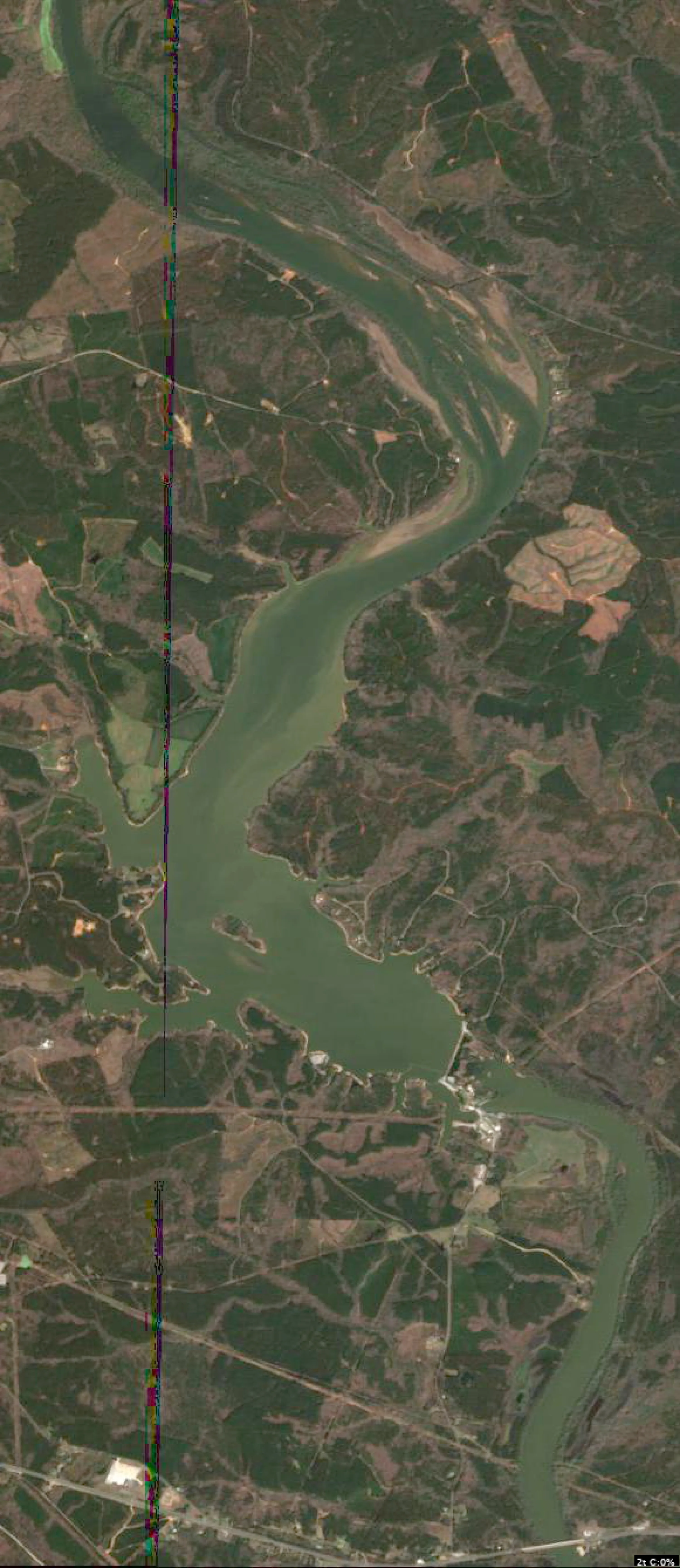
Analyze Satellite Imagery
This analysis of Blewett Falls Lake is based on the provided satellite imagery. Given the current water temperature of 51°F, fish are likely in a pre-spawn transition, moving from the main riverine sections toward the secondary points and protected coves.
1. LAKE OVERVIEW
Blewett Falls Lake functions as a classic river-run reservoir.
- Northern Section (Riverine): The upper portion is narrow, characterized by a distinct, winding river channel.
- Main Lake Body: The central area where the lake widens significantly, featuring the primary dam structure at the southern end.
- Major Landmarks: The most prominent landmark is the Blewett Falls Dam at the southern end. The lake is defined by its transition from the narrow, current-heavy northern river section to the broader, more stable main basin.
2. FINDABLE FISHING SPOTS
Spot 1: The Northern River Bend
- General Area: Northern section.
- How to Find It: Follow the main river channel north until you reach the sharp "S" curve where the channel swings against the western bank.
- What You See: A distinct, narrow channel edge pushing against a steep bank.
- Why Fish It: Current breaks are critical in 51°F water. Fish will hold on the inside of the bend or behind any visible wood/laydowns.
- Best Approach: Cast parallel to the bank, working lures with the current.
Spot 2: The Mid-Lake Western Point
- General Area: Main lake body.
- How to Find It: Locate the large, prominent point on the western shore, roughly halfway between the northern river section and the dam.
- What You See: A long, tapering point extending into the main basin.
- Why Fish It: This is a classic staging area. Fish moving from the river toward the spawning coves will stop here.
- Best Approach: Work the point from deep to shallow with a jig or crankbait.
Spot 3: The Dam Face
- General Area: Southern section.
- How to Find It: Navigate to the extreme southern end of the lake at the Blewett Falls Dam.
- What You See: The concrete dam structure and the rip-rap along the shoreline.
- Why Fish It: The rocks absorb heat, warming the water slightly—a major advantage in 51°F conditions.
- Best Approach: Slow-roll a spinnerbait or drag a soft plastic along the rip-rap.
Spot 4: The Eastern Cove Mouth
- General Area: Main lake body (Eastern shore).
- How to Find It: On the eastern side of the main lake, look for the first significant indentation/cove north of the dam.
- What You See: A distinct "mouth" where the cove meets the main lake.
- Why Fish It: The transition from the main lake to the shallower cove is a primary migration route for pre-spawn fish.
- Best Approach: Focus on the points at the mouth of the cove.
3. VISIBLE FEATURES BY SECTION
- Northern Section:
- River Channel: The serpentine dark line is the primary feature. Focus on where the channel swings close to the bank.
- Inside Bends: Look for sediment deposits (lighter color) which indicate shallower water.
- Main Lake Body:
- Western Points: Several long, finger-like points extend into the main body; these are high-priority staging areas.
- Central Island: A small island is visible in the lower-middle section; the water surrounding this island is a prime target for offshore structure fishing.
- Southern Section:
- Dam Rip-Rap: The most consistent structure in the lake for early-season warming.
- Cove Entrances: The eastern shoreline features several small coves that act as natural funnels for migrating fish.
4. PRACTICAL FISHING GUIDANCE
- Progression:
- Start (Early Morning): Begin in the Main Lake Body near the western points. The water here is more stable, and fish will be staging on these points before moving shallow.
- Mid-Morning: Move to the Dam Face. As the sun hits the rip-rap, the water temperature will rise, potentially triggering a bite.
- Afternoon: If the bite is slow, head to the Northern River Section. The current can keep fish active, and the channel swings provide clear targets.
- Navigation:
- When moving from the northern river section to the main lake, stay within the channel markers. The transition is marked by the lake widening significantly; use the central island as a navigation waypoint to orient yourself toward the dam.
Findings:
- This analysis of Blewett Falls Lake is based on the provided satellite imagery. Given the current water temperature of 51°F, fish are likely in a pre-spawn transition, moving from the main riverine sections toward the secondary points and protected coves.
1. LAKE OVERVIEW
Blewett Falls Lake functions as a classic river-run reservoir.
- Northern Section (Riverine): The upper portion is narrow, characterized by a distinct, winding river channel.
- Main Lake Body: The central area where the lake widens significantly, featuring the primary dam structure at the southern end.
- Major Landmarks: The most prominent landmark is the Blewett Falls Dam at the southern end. The lake is defined by its transition from the narrow, current-heavy northern river section to the broader, more stable main basin.
2. FINDABLE FISHING SPOTS
Spot 1: The Northern River Bend
- General Area: Northern section.
- How to Find It: Follow the main river channel north until you reach the sharp "S" curve where the channel swings against the western bank.
- What You See: A distinct, narrow channel edge pushing against a steep bank.
- Why Fish It: Current breaks are critical in 51°F water. Fish will hold on the inside of the bend or behind any visible wood/laydowns.
- Best Approach: Cast parallel to the bank, working lures with the current.
Spot 2: The Mid-Lake Western Point
- General Area: Main lake body.
- How to Find It: Locate the large, prominent point on the western shore, roughly halfway between the northern river section and the dam.
- What You See: A long, tapering point extending into the main basin.
- Why Fish It: This is a classic staging area. Fish moving from the river toward the spawning coves will stop here.
- Best Approach: Work the point from deep to shallow with a jig or crankbait.
Spot 3: The Dam Face
- General Area: Southern section.
- How to Find It: Navigate to the extreme southern end of the lake at the Blewett Falls Dam.
- What You See: The concrete dam structure and the rip-rap along the shoreline.
- Why Fish It: The rocks absorb heat, warming the water slightly—a major advantage in 51°F conditions.
- Best Approach: Slow-roll a spinnerbait or drag a soft plastic along the rip-rap.
Spot 4: The Eastern Cove Mouth
- General Area: Main lake body (Eastern shore).
- How to Find It: On the eastern side of the main lake, look for the first significant indentation/cove north of the dam.
- What You See: A distinct "mouth" where the cove meets the main lake.
- Why Fish It: The transition from the main lake to the shallower cove is a primary migration route for pre-spawn fish.
- Best Approach: Focus on the points at the mouth of the cove.
3. VISIBLE FEATURES BY SECTION
- Northern Section:
- River Channel: The serpentine dark line is the primary feature. Focus on where the channel swings close to the bank.
- Inside Bends: Look for sediment deposits (lighter color) which indicate shallower water.
- Main Lake Body:
- Western Points: Several long, finger-like points extend into the main body; these are high-priority staging areas.
- Central Island: A small island is visible in the lower-middle section; the water surrounding this island is a prime target for offshore structure fishing.
- Southern Section:
- Dam Rip-Rap: The most consistent structure in the lake for early-season warming.
- Cove Entrances: The eastern shoreline features several small coves that act as natural funnels for migrating fish.
4. PRACTICAL FISHING GUIDANCE
- Progression:
- Start (Early Morning): Begin in the Main Lake Body near the western points. The water here is more stable, and fish will be staging on these points before moving shallow.
- Mid-Morning: Move to the Dam Face. As the sun hits the rip-rap, the water temperature will rise, potentially triggering a bite.
- Afternoon: If the bite is slow, head to the Northern River Section. The current can keep fish active, and the channel swings provide clear targets.
- Navigation:
- When moving from the northern river section to the main lake, stay within the channel markers. The transition is marked by the lake widening significantly; use the central island as a navigation waypoint to orient yourself toward the dam.
How this was synthesized
Professional fishing guide analysis integrating 8 tools: analyze_weather_conditions, lure_matrix_wind_clarity, estimate_seasonal_phase, analyze_solunar_timing, analyze_species_behavior, analyze_thermal_patterns, analyze_water_clarity, analyze_satellite_imagery. User request: 'Generate a comprehensive fishing report for Blewett Falls Lake. Use tools to analyze satellite structure, thermal patterns, water clarity, weather, and solunar timing, then synthesize a concise plan.'. Synthesis generated comprehensive plan with professional recommendations.