Lake Norman Fishing Report
Synthesis generated comprehensive plan with professional recommendations.
Lake Norman Fishing Report
Generated Feb 27, 2026, 3:14 AM.
Key fishing read
- Rising pressure trend (1011.00 → higher). Bite may slow down as fish become less active.
- Switch to finesse tactics, target deeper structure. Fish will be less aggressive.
- Loud/bright: chartreuse/black, Colorado blades, big profile cranks
- Day 1: High pressure (1011mb) - tougher bite, use finesse tactics
- Day 1: Moderate wind (8mph) - ideal conditions, target windblown points
- Day 1: HeavyRain, High: 57°F, Low: 50°F
- Day 2: High pressure (1016mb) - tougher bite, use finesse tactics
- Day 2: High winds (21mph) - seek protected areas, use heavier lures
Tool analysis details
Analyze Pressure Trends
Barometric pressure analysis for Lake Norman: rising trend at 1011.00mb
Findings:
- Rising pressure trend (1011.00 → higher). Bite may slow down as fish become less active.
- Switch to finesse tactics, target deeper structure. Fish will be less aggressive.
Lure Matrix Wind Clarity
Lure guidance for wind=moderate, clarity=unknown.
Findings:
- Loud/bright: chartreuse/black, Colorado blades, big profile cranks
Analyze Weather Conditions
Weather analysis for Lake Norman completed
Findings:
- Day 1: High pressure (1011mb) - tougher bite, use finesse tactics
- Day 1: Moderate wind (8mph) - ideal conditions, target windblown points
- Day 1: HeavyRain, High: 57°F, Low: 50°F
- Day 2: High pressure (1016mb) - tougher bite, use finesse tactics
- Day 2: High winds (21mph) - seek protected areas, use heavier lures
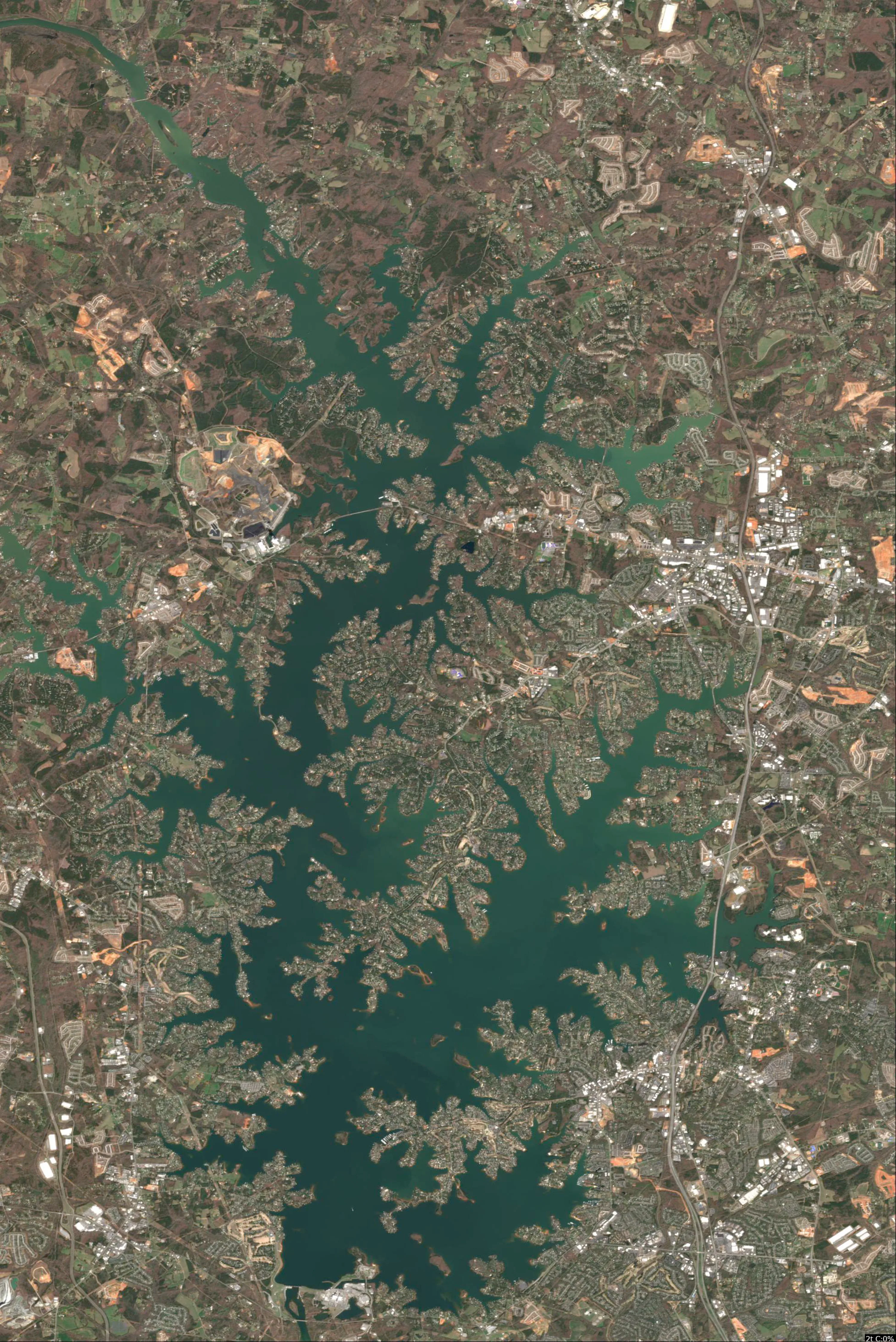
Analyze Satellite Imagery
Lake Norman Satellite Analysis - February 27, 2026 (43°F, Winter/Pre-Spawn)
1. LAKE OVERVIEW (Natural Sections & Landmarks)
Lake Norman appears as a large, irregularly shaped reservoir elongated north-south, approximately 30+ miles long with a wide central main lake body flanked by multiple arms.
- Main lake body: Broad open central area with scattered islands and long shorelines.
- Northern section/arm: Narrower, more river-like upper end tapering northward, divided by a prominent east-west bridge (NC 150).
- Southern section/arm: Wider basin near the southern dam, with a major east arm extending southeast and west arm southwest.
- Major creek arms: Distinct eastern arm (McCrary Creek area) funneling into main lake; western arm with visible narrows; smaller coves along northern shores.
- Upper vs lower lake: Upper (northern) is tighter with creek influences; lower (southern/main) is expansive open water.
- Major landmarks:
- I-77 bridge crossing the main lake body east-west.
- NC 150 bridge narrowing the northern section.
- Multiple marinas (large clusters of docks on western main lake shore and southern arm).
- Boat ramps visible at northern section (near NC 150), main lake west shore, and southern east arm.
- Scattered islands in main lake (one prominent pair near I-77).
- Southern dam visible as straight shoreline edge.
- Natural divisions: Narrowed by NC 150 bridge (north), I-77 bridge (central), and long points/arms creating protected coves.
Color gradients show light blue/tan shallows along many shorelines transitioning to medium/dark blue offshore, with sharp lines indicating drop-offs at points.
2. FINDABLE FISHING SPOTS
Identified 6 high-priority spots based on visible structure (points, channels), cover (docks, laydowns), and color transitions. Prioritized for winter bass/crappie using deep-adjacent structure. Each rated 1-10 on structure complexity, cover, depth access, species fit, seasonal match, wind protection.
-
General Area: Northern section
How to Find It: Launch at northern boat ramp near NC 150 bridge, head south along east shore to first major point with dock cluster.
What You See: Point jutting west into lake with 5-6 docks, sharp color change from light tan shallows to dark blue offshore, serpentine dark line (channel) nearby.
Why Fish It: Point with docks offers structure/cover combo; channel bend holds winter bass staging pre-spawn (largemouth/spotted). Priority: 9/10 (high structure, seasonal channel access).
Best Approach: Anchor on point edge, fish docks with jigs or drop-shot for suspended bass. -
General Area: Main lake body - west shore
How to Find It: From I-77 bridge, head west to large marina with extensive docks, then north to adjacent point.
What You See: Long point with linear laydowns from shore, heavy dock cover, medium-to-dark blue transition offshore.
Why Fish It: Laydowns on drop-off point ideal for largemouth holding deep; wind-protected by marina. Priority: 8/10 (cover density, bass habitat).
Best Approach: Drift point with swimbaits or fan-cast laydowns with shaky head. -
General Area: Main lake body - central islands
How to Find It: Locate pair of islands just north of I-77 bridge, focus on east-side point of larger island.
What You See: Island point extending into dark blue with surrounding light shallows, small dock shadows on shore.
Why Fish It: Offshore point with adjacent flats matches winter refuge/feeding for striped/white bass. Priority: 7/10 (structure isolation, multi-species).
Best Approach: Circle island, troll or cast crankbaits along color edges. -
General Area: Southern section - east arm (McCrary Creek)
How to Find It: From southern dam, head northeast into east arm to creek mouth where narrow channel enters.
What You See: Dark serpentine channel line from creek into main lake, flanked by shallow tan flats and dock clusters.
Why Fish It: Creek channel bend with docks perfect pre-spawn staging for spotted bass/crappie. Priority: 9/10 (channel structure, seasonal migration path).
Best Approach: Position in channel, vertical jig or cast to docks. -
General Area: Southern section - west shore
How to Find It: South of main west marina, find protected cove with boat ramp, target rear point.
What You See: Cove point with irregular dark patches (possible brush/veggies), docks, sharp offshore color line.
Why Fish It: Protected cove point with cover suits crappie in brush; drop-off for bass. Priority: 8/10 (cover type, wind protection).
Best Approach: Fish cove rear with minnows under docks or jigs on point. -
General Area: Northern section - west shore
How to Find It: From NC 150 bridge, cross to west shore, south to cluster of houses/docks on point.
What You See: Point with multiple docks and laydowns, light-to-dark color shift, nearby narrows.
Why Fish It: Steep bank point with cover for smallmouth/largemouth in winter depths. Priority: 7/10 (transition access, species variety).
Best Approach: Parallel shore with blade baits or tube jigs.
3. VISIBLE FEATURES BY LAKE SECTION
Northern section:
- East shore: Major point with dock cluster south of NC 150 bridge; serpentine dark lines (channels) entering coves.
- West shore: House/dock clusters on points; narrow channel through bridge area.
- General: Tan shallows along shores, dark blue pockets offshore.
Main lake body:
- West shore: Large marina with parallel docks; long points with laydowns north of marina.
- Central: Pair of islands with points; I-77 bridge creating windbreaks.
- East shore: Scattered docks, color transitions at extended points.
- General: Broad dark blue open water, light patches around islands.
Southern section:
- East arm: Creek mouth with channel line, dock groups in coves.
- West shore: Boat ramp/cove with rear point; marina clusters.
- Near dam: Straight shore with adjacent points.
- General: Wider dark areas, tan shallows in arms.
Eastern/Western arms: Eastern (McCrary): Channel inflows, protected coves. Western: Narrows with docks, points leading to main lake.
4. PRACTICAL FISHING GUIDANCE
Suggested fishing progression:
- Start (early morning): Northern section - point south of NC 150 boat ramp (priority 9 spot). Fish deep edges for staging bass as water warms slightly.
- Mid-morning: Move to main lake west shore marina point (priority 8). Wind often pushes bait here midday.
- Pattern: Northern channels early (pre-spawn pull), main lake points midday (thermal refuge), southern arms afternoon (protected deeps). Relate sections via channels: winter fish migrate from northern creeks to main lake basins.
Navigation between sections:
- Northern to main lake: Pass under NC 150 bridge, stay mid-lake to avoid shallows.
- Main lake to southern: Go under I-77 bridge, hug west shore past marina for west arm or east for McCrary.
- Southern arms: From main lake, round points/islands to enter; use marinas/ramps as beacons.
Focus on visible drop-offs (color lines) and dock-covered points for winter success—bass/crappie hug these in 43°F. Safe boating!
Findings:
-
Lake Norman Satellite Analysis - February 27, 2026 (43°F, Winter/Pre-Spawn)
1. LAKE OVERVIEW (Natural Sections & Landmarks)
Lake Norman appears as a large, irregularly shaped reservoir elongated north-south, approximately 30+ miles long with a wide central main lake body flanked by multiple arms.
- Main lake body: Broad open central area with scattered islands and long shorelines.
- Northern section/arm: Narrower, more river-like upper end tapering northward, divided by a prominent east-west bridge (NC 150).
- Southern section/arm: Wider basin near the southern dam, with a major east arm extending southeast and west arm southwest.
- Major creek arms: Distinct eastern arm (McCrary Creek area) funneling into main lake; western arm with visible narrows; smaller coves along northern shores.
- Upper vs lower lake: Upper (northern) is tighter with creek influences; lower (southern/main) is expansive open water.
- Major landmarks:
- I-77 bridge crossing the main lake body east-west.
- NC 150 bridge narrowing the northern section.
- Multiple marinas (large clusters of docks on western main lake shore and southern arm).
- Boat ramps visible at northern section (near NC 150), main lake west shore, and southern east arm.
- Scattered islands in main lake (one prominent pair near I-77).
- Southern dam visible as straight shoreline edge.
- Natural divisions: Narrowed by NC 150 bridge (north), I-77 bridge (central), and long points/arms creating protected coves.
Color gradients show light blue/tan shallows along many shorelines transitioning to medium/dark blue offshore, with sharp lines indicating drop-offs at points.
2. FINDABLE FISHING SPOTS
Identified 6 high-priority spots based on visible structure (points, channels), cover (docks, laydowns), and color transitions. Prioritized for winter bass/crappie using deep-adjacent structure. Each rated 1-10 on structure complexity, cover, depth access, species fit, seasonal match, wind protection.
-
General Area: Northern section
How to Find It: Launch at northern boat ramp near NC 150 bridge, head south along east shore to first major point with dock cluster.
What You See: Point jutting west into lake with 5-6 docks, sharp color change from light tan shallows to dark blue offshore, serpentine dark line (channel) nearby.
Why Fish It: Point with docks offers structure/cover combo; channel bend holds winter bass staging pre-spawn (largemouth/spotted). Priority: 9/10 (high structure, seasonal channel access).
Best Approach: Anchor on point edge, fish docks with jigs or drop-shot for suspended bass. -
General Area: Main lake body - west shore
How to Find It: From I-77 bridge, head west to large marina with extensive docks, then north to adjacent point.
What You See: Long point with linear laydowns from shore, heavy dock cover, medium-to-dark blue transition offshore.
Why Fish It: Laydowns on drop-off point ideal for largemouth holding deep; wind-protected by marina. Priority: 8/10 (cover density, bass habitat).
Best Approach: Drift point with swimbaits or fan-cast laydowns with shaky head. -
General Area: Main lake body - central islands
How to Find It: Locate pair of islands just north of I-77 bridge, focus on east-side point of larger island.
What You See: Island point extending into dark blue with surrounding light shallows, small dock shadows on shore.
Why Fish It: Offshore point with adjacent flats matches winter refuge/feeding for striped/white bass. Priority: 7/10 (structure isolation, multi-species).
Best Approach: Circle island, troll or cast crankbaits along color edges. -
General Area: Southern section - east arm (McCrary Creek)
How to Find It: From southern dam, head northeast into east arm to creek mouth where narrow channel enters.
What You See: Dark serpentine channel line from creek into main lake, flanked by shallow tan flats and dock clusters.
Why Fish It: Creek channel bend with docks perfect pre-spawn staging for spotted bass/crappie. Priority: 9/10 (channel structure, seasonal migration path).
Best Approach: Position in channel, vertical jig or cast to docks. -
General Area: Southern section - west shore
How to Find It: South of main west marina, find protected cove with boat ramp, target rear point.
What You See: Cove point with irregular dark patches (possible brush/veggies), docks, sharp offshore color line.
Why Fish It: Protected cove point with cover suits crappie in brush; drop-off for bass. Priority: 8/10 (cover type, wind protection).
Best Approach: Fish cove rear with minnows under docks or jigs on point. -
General Area: Northern section - west shore
How to Find It: From NC 150 bridge, cross to west shore, south to cluster of houses/docks on point.
What You See: Point with multiple docks and laydowns, light-to-dark color shift, nearby narrows.
Why Fish It: Steep bank point with cover for smallmouth/largemouth in winter depths. Priority: 7/10 (transition access, species variety).
Best Approach: Parallel shore with blade baits or tube jigs.
3. VISIBLE FEATURES BY LAKE SECTION
Northern section:
- East shore: Major point with dock cluster south of NC 150 bridge; serpentine dark lines (channels) entering coves.
- West shore: House/dock clusters on points; narrow channel through bridge area.
- General: Tan shallows along shores, dark blue pockets offshore.
Main lake body:
- West shore: Large marina with parallel docks; long points with laydowns north of marina.
- Central: Pair of islands with points; I-77 bridge creating windbreaks.
- East shore: Scattered docks, color transitions at extended points.
- General: Broad dark blue open water, light patches around islands.
Southern section:
- East arm: Creek mouth with channel line, dock groups in coves.
- West shore: Boat ramp/cove with rear point; marina clusters.
- Near dam: Straight shore with adjacent points.
- General: Wider dark areas, tan shallows in arms.
Eastern/Western arms: Eastern (McCrary): Channel inflows, protected coves. Western: Narrows with docks, points leading to main lake.
4. PRACTICAL FISHING GUIDANCE
Suggested fishing progression:
- Start (early morning): Northern section - point south of NC 150 boat ramp (priority 9 spot). Fish deep edges for staging bass as water warms slightly.
- Mid-morning: Move to main lake west shore marina point (priority 8). Wind often pushes bait here midday.
- Pattern: Northern channels early (pre-spawn pull), main lake points midday (thermal refuge), southern arms afternoon (protected deeps). Relate sections via channels: winter fish migrate from northern creeks to main lake basins.
Navigation between sections:
- Northern to main lake: Pass under NC 150 bridge, stay mid-lake to avoid shallows.
- Main lake to southern: Go under I-77 bridge, hug west shore past marina for west arm or east for McCrary.
- Southern arms: From main lake, round points/islands to enter; use marinas/ramps as beacons.
Focus on visible drop-offs (color lines) and dock-covered points for winter success—bass/crappie hug these in 43°F. Safe boating!
Analyze Thermal Patterns
Overall Thermal Landscape Summary
Assuming North is at the top of the image (standard orientation for satellite imagery), this is a highly irregular reservoir with a narrow, branching northern section featuring multiple long, finger-like arms extending northwest, north, and northeast, funneling into a wider, more rounded southern basin. Major visual anchors for reference: (1) the broad southern basin occupying the bottom third, marked by a prominent 60° label near its center-east edge; (2) the long, straight western arm (left side, top two-thirds) with a 54° label midway along its length; (3) the eastern arm (right side, middle third) narrowing sharply southward, with clustered 52° and 45° labels near its mid-southern extent. Dominant colors are cyan/light teal (56-60°F / 13-16°C) across most open water areas, with patches of medium blue (46-52°F / 8-11°C) in northern extremities and light green (60-64°F / 16-18°C) concentrated in the southern basin. Approximate min/max visible temperatures: 45°F (5°C, medium blue at labeled spots) to 60°F (16°C, light green at southern label).
Detailed Thermal Feature Analysis
Temperature Breaks
- Abrupt transitions from medium blue (46-52°F / 8-11°C) to cyan/light teal (56-60°F / 13-16°C) occur along the southern boundaries of the northern arms, specifically where the long western arm (54° label midway) converges into the broad southern basin—visible as a sharp color shift just north of the 60° label. Similarly, on the eastern arm, a distinct break runs parallel to the narrowing shoreline section south of the 52°/45° cluster, shifting from medium blue to cyan.
- These breaks are moderately sharp (not gradual), spanning ~4-10°F (2-5°C) over short distances, indicating surface inflows or mixing zones.
Pockets/Patches
- Isolated medium blue patches (46-52°F / 8-11°C), matching the 45° and 52° labels, form small, irregular pockets within the eastern arm's narrow mid-section (right side, middle third, just north of the sharp eastern shoreline bend).
- A warmer light green patch (60-64°F / 16-18°C), aligned with the 60° label, occupies a circular area in the southeast quadrant of the southern basin, bordered by the basin's eastern shoreline curve.
- No very dark navy blue (40-42°F / 4-6°C) or red/orange (76-80°F / 24-27°C) visible; patterns are subtle and clustered around labels.
Gradients
- Gradual north-south gradients from cyan/light teal (56-60°F / 13-16°C) in the northern arms (e.g., around 54° label in western arm) to light green (60-64°F / 16-18°C) in the southern basin, spanning the central constriction (center image, middle third). This is evident as a smooth color fade along the main channel connecting the western arm to the basin.
- Minor east-west gradients in the southern basin, with cyan shading lightly toward the west shore transitioning to light green near the 60° label.
Uniform Areas
- Large uniform cyan/light teal zones (56-60°F / 13-16°C) cover the interiors of the long western arm (left side, full length north of 54° label) and the northeast-extending arm (top-right), suggesting stable surface temperatures with minimal variation.
- The broad southern basin shows semi-uniform light green/cyan (58-62°F / 14-17°C average), most consistent around the 57° and 60° labels, interrupted only by shoreline transitions.
Insightful Fish Behavior Interpretation
Visible surface temperatures in the cyan/light teal (56-60°F / 13-16°C) and light green (60-64°F / 16-18°C) ranges indicate spring warming conditions with active feeding and transitional movements, especially in the southern basin where fish are likely very active and aggressive near the surface. Cooler medium blue pockets (46-52°F / 8-11°C) in the northern/eastern arms suggest sluggish, structure-oriented behavior with minimal surface activity. Fish will concentrate along temperature breaks (e.g., arm-to-basin transitions) for comfort and feeding, using warmer zones for staging and cooler inflows for ambush points—expect surface-oriented bites like topwater or shallow crankbaits during peak activity windows. Uniform cyan areas imply broad distribution but low contrast, driving fish to edges and gradients for optimal comfort.
Satellite Correlation Analysis
No separate standard satellite imagery (e.g., visible light ortho) is provided alongside the thermal data, so correlation is limited to thermal-shoreline geometry. The cooler medium blue pockets (45°/52° labels) in the eastern arm align with narrow, U-shaped shoreline inlets, likely surface expression of creek inflows mixing cooler water. The light green 60° patch in the southern basin corresponds to a shallow, rounded embayment off the southeast shore, suggesting wind-mixing or solar heating on exposed flats. Warmer gradients into the basin match funnel-like channel geometry from northern arms, indicating surface current convergence without depth inferences.
Actionable Fishing Recommendations
- Prime Zones: Target the light green patch (60-64°F / 16-18°C) in the southeast of the southern basin (near 60° label, inside the rounded embayment east of center)—fish shallow flats with aggressive lures like spinnerbaits for peak surface feeding.
- Transition Hotspots: Drift or cast along the sharp color breaks where northern arms enter the basin: specifically, the western arm convergence just south of the 54° label (parallel to straight western shoreline), and eastern arm south of 52°/45° cluster—use finesse swimbaits or jerkbaits to exploit 4-10°F (2-5°C) shifts attracting staging fish.
- Secondary Areas: Probe medium blue pockets (46-52°F / 8-11°C) in the eastern arm's narrow mid-section (around clustered labels) with slow presentations like drop-shots for lethargic fish hugging inflows.
- Tactics: Focus dawn/dusk surface action in warmer light green/cyan; avoid deep uniform cyan interiors. Use 10-20' lines to stay in surface-influenced shallows near described anchors—image quality supports clear pattern ID but subtle gradients limit pinpoint depth calls.
Findings:
- Current surface temperature: 43.0°F. Fish metabolism significantly reduced in cold water. Target sunny, protected shorelines and use extremely slow presentations. Focus on midday when surface temperatures are warmest.
-
Overall Thermal Landscape Summary
Assuming North is at the top of the image (standard orientation for satellite imagery), this is a highly irregular reservoir with a narrow, branching northern section featuring multiple long, finger-like arms extending northwest, north, and northeast, funneling into a wider, more rounded southern basin. Major visual anchors for reference: (1) the broad southern basin occupying the bottom third, marked by a prominent 60° label near its center-east edge; (2) the long, straight western arm (left side, top two-thirds) with a 54° label midway along its length; (3) the eastern arm (right side, middle third) narrowing sharply southward, with clustered 52° and 45° labels near its mid-southern extent. Dominant colors are cyan/light teal (56-60°F / 13-16°C) across most open water areas, with patches of medium blue (46-52°F / 8-11°C) in northern extremities and light green (60-64°F / 16-18°C) concentrated in the southern basin. Approximate min/max visible temperatures: 45°F (5°C, medium blue at labeled spots) to 60°F (16°C, light green at southern label).
Detailed Thermal Feature Analysis
Temperature Breaks
- Abrupt transitions from medium blue (46-52°F / 8-11°C) to cyan/light teal (56-60°F / 13-16°C) occur along the southern boundaries of the northern arms, specifically where the long western arm (54° label midway) converges into the broad southern basin—visible as a sharp color shift just north of the 60° label. Similarly, on the eastern arm, a distinct break runs parallel to the narrowing shoreline section south of the 52°/45° cluster, shifting from medium blue to cyan.
- These breaks are moderately sharp (not gradual), spanning ~4-10°F (2-5°C) over short distances, indicating surface inflows or mixing zones.
Pockets/Patches
- Isolated medium blue patches (46-52°F / 8-11°C), matching the 45° and 52° labels, form small, irregular pockets within the eastern arm's narrow mid-section (right side, middle third, just north of the sharp eastern shoreline bend).
- A warmer light green patch (60-64°F / 16-18°C), aligned with the 60° label, occupies a circular area in the southeast quadrant of the southern basin, bordered by the basin's eastern shoreline curve.
- No very dark navy blue (40-42°F / 4-6°C) or red/orange (76-80°F / 24-27°C) visible; patterns are subtle and clustered around labels.
Gradients
- Gradual north-south gradients from cyan/light teal (56-60°F / 13-16°C) in the northern arms (e.g., around 54° label in western arm) to light green (60-64°F / 16-18°C) in the southern basin, spanning the central constriction (center image, middle third). This is evident as a smooth color fade along the main channel connecting the western arm to the basin.
- Minor east-west gradients in the southern basin, with cyan shading lightly toward the west shore transitioning to light green near the 60° label.
Uniform Areas
- Large uniform cyan/light teal zones (56-60°F / 13-16°C) cover the interiors of the long western arm (left side, full length north of 54° label) and the northeast-extending arm (top-right), suggesting stable surface temperatures with minimal variation.
- The broad southern basin shows semi-uniform light green/cyan (58-62°F / 14-17°C average), most consistent around the 57° and 60° labels, interrupted only by shoreline transitions.
Insightful Fish Behavior Interpretation
Visible surface temperatures in the cyan/light teal (56-60°F / 13-16°C) and light green (60-64°F / 16-18°C) ranges indicate spring warming conditions with active feeding and transitional movements, especially in the southern basin where fish are likely very active and aggressive near the surface. Cooler medium blue pockets (46-52°F / 8-11°C) in the northern/eastern arms suggest sluggish, structure-oriented behavior with minimal surface activity. Fish will concentrate along temperature breaks (e.g., arm-to-basin transitions) for comfort and feeding, using warmer zones for staging and cooler inflows for ambush points—expect surface-oriented bites like topwater or shallow crankbaits during peak activity windows. Uniform cyan areas imply broad distribution but low contrast, driving fish to edges and gradients for optimal comfort.
Satellite Correlation Analysis
No separate standard satellite imagery (e.g., visible light ortho) is provided alongside the thermal data, so correlation is limited to thermal-shoreline geometry. The cooler medium blue pockets (45°/52° labels) in the eastern arm align with narrow, U-shaped shoreline inlets, likely surface expression of creek inflows mixing cooler water. The light green 60° patch in the southern basin corresponds to a shallow, rounded embayment off the southeast shore, suggesting wind-mixing or solar heating on exposed flats. Warmer gradients into the basin match funnel-like channel geometry from northern arms, indicating surface current convergence without depth inferences.
Actionable Fishing Recommendations
- Prime Zones: Target the light green patch (60-64°F / 16-18°C) in the southeast of the southern basin (near 60° label, inside the rounded embayment east of center)—fish shallow flats with aggressive lures like spinnerbaits for peak surface feeding.
- Transition Hotspots: Drift or cast along the sharp color breaks where northern arms enter the basin: specifically, the western arm convergence just south of the 54° label (parallel to straight western shoreline), and eastern arm south of 52°/45° cluster—use finesse swimbaits or jerkbaits to exploit 4-10°F (2-5°C) shifts attracting staging fish.
- Secondary Areas: Probe medium blue pockets (46-52°F / 8-11°C) in the eastern arm's narrow mid-section (around clustered labels) with slow presentations like drop-shots for lethargic fish hugging inflows.
- Tactics: Focus dawn/dusk surface action in warmer light green/cyan; avoid deep uniform cyan interiors. Use 10-20' lines to stay in surface-influenced shallows near described anchors—image quality supports clear pattern ID but subtle gradients limit pinpoint depth calls.
- Winter surface patterns: Target the warmest surface areas during midday, typically along north-facing shorelines and sun-exposed areas. Use slow presentations as fish metabolism is reduced.
Analyze Water Clarity
1. Overall Water Quality Summary
The imagery reveals a stark contrast across Lake Norman, with the main body dominated by dark blue/teal colors in both visuals (bottom-left matrix quadrant: low sediment + low chlorophyll), indicating exceptionally clear conditions (15-25+ feet visibility) in open waters. Narrow branching arms, coves, and creek channels show intense red/orange (first image, bottom-right quadrant: high chlorophyll + low sediment) transitioning to brown/tan overlays (second image, top-left quadrant: low chlorophyll + high sediment), combining into top-center/top-right matrix positions (moderate-to-high chlorophyll + high sediment) with very poor visibility (<2-4 feet). This pattern suggests nutrient-rich, turbid inflows confined to extremities, preserving main-lake clarity.
2. Detailed Clarity Zone Mapping & Characterization
Zone 1: Main Basin (Central Dark Blue/Teal Areas)
- Matrix Position Analysis: Dark blue/teal dominant in both images (bottom-left quadrant).
- Combined Conditions: Low sediment + low chlorophyll = minimal particles/algae, 15-25+ feet visibility.
- Location Mapping: Central lake body, spanning north-south axis, excluding peripheral branches (e.g., broad open waters southeast of central narrows).
- Visibility Assessment: Premium sight-fishing conditions.
- Tactical Implications: Finesse natural presentations; transition to Zone 2 at branching edges.
Zone 2: Western Arms/Coves (Red/Orange Branches in Image 1 + Brown Overlay in Image 2)
- Matrix Position Analysis: Red/orange (bottom-right) overlaid with brown/tan (top-left), shifting to top-center (brown/green mix).
- Combined Conditions: High chlorophyll + moderate-high sediment = stained productive water, 1-4 feet visibility.
- Location Mapping: Western shoreline arms, fractal branching northwest and southwest (e.g., elongated coves protruding west from main body).
- Visibility Assessment: Challenging but fishable with vibration.
- Tactical Implications: Loud rattles/bright colors; prime edge at main body interface.
Zone 3: Eastern Creeks/Channels (Intense Red Branching in Image 1 + Tan in Image 2)
- Matrix Position Analysis: Bright red/yellow branching (bottom-right/high chlorophyll low sediment) + heavy tan/brown (top-left/high sediment low chlorophyll) = top-right (dark brown/red mix).
- Combined Conditions: High chlorophyll + high sediment = worst visibility, <2 feet.
- Location Mapping: Eastern extremities, dense branching northeast and southeast (e.g., narrow creek-like intrusions along eastern shore).
- Visibility Assessment: Extremely low, sound/vibration critical.
- Tactical Implications: Maximum noise baits; fish blindly near structure.
Zone 4: Southern Inflow Branches (Yellow-Green Tinged Red in Image 1 + Light Brown in Image 2)
- Matrix Position Analysis: Yellow-green edges (bottom-center/moderate chlorophyll low sediment) + light tan (top-left) = top-center mix.
- Combined Conditions: Moderate chlorophyll + high sediment = stained, 1-4 feet visibility.
- Location Mapping: Southern shallow flats/arms (e.g., protruding south-central branches near presumed inflows).
- Visibility Assessment: Marginal, slow finesse needed.
- Tactical Implications: Mixed bright/natural colors at color-shift boundaries.
Transition Zone Identification: Sharp color breaks where dark blue meets red/brown branches (e.g., east-west lines at arm mouths), indicating high-productivity edges.
3. Turbidity/Algae Sources & Transition Zones Analysis
Source Identification (Visual): High sediment (brown/tan in Image 2) originates from shallow branching arms, likely wind-stirred flats or runoff points in western/southern coves. High chlorophyll (red/orange/yellow in Image 1) concentrates in the same eastern/northern channels, suggesting nutrient inflows fueling algae in protected branches. No widespread turbidity in main body.
Clarity Breaks/Edges: Sharp transitions dominate—e.g., abrupt dark blue-to-red "vein edges" along western arm mouths (high chlorophyll front), tan-brown "mudlines" protruding into central blue from eastern creeks (sediment plumes), and gradual yellow-to-dark brown fades in southern branches. These edges signify bait traps/ambush points, with fish likely staging at the clear-turbid interface for reaction feeding.
4. Species-Specific Clarity Strategy (Recommendations tied to zones)
- Bass (Largemouth/Smallmouth): Target Zone 2 western arms and transition edges (top-center mix, 1-4 ft vis)—patrol red/brown branch mouths ambushing from turbid water into clearer main body; avoid deep Zone 1 main basin where sluggish in 43°F.
- Crappie: Suspend near cover in Zone 4 southern branches (moderate-high sediment/chlorophyll edges), where stained conditions cluster schools at 1-4 ft vis along yellow-tan shifts.
- Striped Bass/Linesides: School in Zone 1 main basin (clear blue/teal, 15-25+ ft) for sight-chasing baitfish, or chase shad to Zone 3 eastern creek edges (top-right poor vis) for blitzes at mudlines.
- Catfish: Bottom-drag in Zone 3 eastern/worst-vis channels (<2 ft, high sediment), using structure in tan/red branches.
5. Tactical Fishing Adjustments (Lures/Presentations tied to zones)
Zone 1 (Clear Blue/Teal, 15-25+ ft): Natural colors (green pumpkin, shad, watermelon seed) on jigs/soft plastics/suspending jerkbaits; slow finesse retrieves (downsize 25% for 43°F), long casts (40+ yd), fluorocarbon 8-12 lb, distant boat positioning. Fish clarity breaks with subtle twitches.
Zone 2 (Stained Red/Brown Mix, 1-4 ft): Bright chartreuse/white/blues on chatterbaits/spinnerbaits; moderate-fast retrieves with rattles, mono/fluoro 12-15 lb, 20-30 yd casts. Along edges, yo-yo reaction baits over the blue-red line.
Zone 3 (Turbid Tan/Red, <2 ft): High-contrast black/blue/chartreuse-orange on lipless crankbaits/big worms/1/2 oz spinnerbaits; vibration-only slow drags, braid 15-20 lb OK, close 10-20 yd presentations. Blind-fish branch structure, scent-enhanced.
Zone 4 (Yellow-Tan, 1-4 ft): Mixed bright/natural (chartreuse/green pumpkin) Ned rigs/drop shots; ultra-slow for cold water, lighter line, target gradual southern edges with pauses.
Clarity Breaks General: Power-finesse hybrids (e.g., slow-rolled spinnerbait) parallel edges; cast from clear side into turbid for ambush triggers.
6. Seasonal Context (Interpretation of visual patterns)
The confined red/orange algae (high chlorophyll) in branches amid widespread tan sediment suggests recent localized runoff or wind-resuspension in shallows, appearing consistent with cold transitional patterns (e.g., post-winter inflows stirring nutrients without full blooms). Main basin's resilient deep blue/teal clarity despite peripheral turbidity indicates stable deeper waters, ideal for sluggish cold-front fishing; no evidence of unusual widespread degradation.
Findings:
-
1. Overall Water Quality Summary
The imagery reveals a stark contrast across Lake Norman, with the main body dominated by dark blue/teal colors in both visuals (bottom-left matrix quadrant: low sediment + low chlorophyll), indicating exceptionally clear conditions (15-25+ feet visibility) in open waters. Narrow branching arms, coves, and creek channels show intense red/orange (first image, bottom-right quadrant: high chlorophyll + low sediment) transitioning to brown/tan overlays (second image, top-left quadrant: low chlorophyll + high sediment), combining into top-center/top-right matrix positions (moderate-to-high chlorophyll + high sediment) with very poor visibility (<2-4 feet). This pattern suggests nutrient-rich, turbid inflows confined to extremities, preserving main-lake clarity.
2. Detailed Clarity Zone Mapping & Characterization
Zone 1: Main Basin (Central Dark Blue/Teal Areas)
- Matrix Position Analysis: Dark blue/teal dominant in both images (bottom-left quadrant).
- Combined Conditions: Low sediment + low chlorophyll = minimal particles/algae, 15-25+ feet visibility.
- Location Mapping: Central lake body, spanning north-south axis, excluding peripheral branches (e.g., broad open waters southeast of central narrows).
- Visibility Assessment: Premium sight-fishing conditions.
- Tactical Implications: Finesse natural presentations; transition to Zone 2 at branching edges.
Zone 2: Western Arms/Coves (Red/Orange Branches in Image 1 + Brown Overlay in Image 2)
- Matrix Position Analysis: Red/orange (bottom-right) overlaid with brown/tan (top-left), shifting to top-center (brown/green mix).
- Combined Conditions: High chlorophyll + moderate-high sediment = stained productive water, 1-4 feet visibility.
- Location Mapping: Western shoreline arms, fractal branching northwest and southwest (e.g., elongated coves protruding west from main body).
- Visibility Assessment: Challenging but fishable with vibration.
- Tactical Implications: Loud rattles/bright colors; prime edge at main body interface.
Zone 3: Eastern Creeks/Channels (Intense Red Branching in Image 1 + Tan in Image 2)
- Matrix Position Analysis: Bright red/yellow branching (bottom-right/high chlorophyll low sediment) + heavy tan/brown (top-left/high sediment low chlorophyll) = top-right (dark brown/red mix).
- Combined Conditions: High chlorophyll + high sediment = worst visibility, <2 feet.
- Location Mapping: Eastern extremities, dense branching northeast and southeast (e.g., narrow creek-like intrusions along eastern shore).
- Visibility Assessment: Extremely low, sound/vibration critical.
- Tactical Implications: Maximum noise baits; fish blindly near structure.
Zone 4: Southern Inflow Branches (Yellow-Green Tinged Red in Image 1 + Light Brown in Image 2)
- Matrix Position Analysis: Yellow-green edges (bottom-center/moderate chlorophyll low sediment) + light tan (top-left) = top-center mix.
- Combined Conditions: Moderate chlorophyll + high sediment = stained, 1-4 feet visibility.
- Location Mapping: Southern shallow flats/arms (e.g., protruding south-central branches near presumed inflows).
- Visibility Assessment: Marginal, slow finesse needed.
- Tactical Implications: Mixed bright/natural colors at color-shift boundaries.
Transition Zone Identification: Sharp color breaks where dark blue meets red/brown branches (e.g., east-west lines at arm mouths), indicating high-productivity edges.
3. Turbidity/Algae Sources & Transition Zones Analysis
Source Identification (Visual): High sediment (brown/tan in Image 2) originates from shallow branching arms, likely wind-stirred flats or runoff points in western/southern coves. High chlorophyll (red/orange/yellow in Image 1) concentrates in the same eastern/northern channels, suggesting nutrient inflows fueling algae in protected branches. No widespread turbidity in main body.
Clarity Breaks/Edges: Sharp transitions dominate—e.g., abrupt dark blue-to-red "vein edges" along western arm mouths (high chlorophyll front), tan-brown "mudlines" protruding into central blue from eastern creeks (sediment plumes), and gradual yellow-to-dark brown fades in southern branches. These edges signify bait traps/ambush points, with fish likely staging at the clear-turbid interface for reaction feeding.
4. Species-Specific Clarity Strategy (Recommendations tied to zones)
- Bass (Largemouth/Smallmouth): Target Zone 2 western arms and transition edges (top-center mix, 1-4 ft vis)—patrol red/brown branch mouths ambushing from turbid water into clearer main body; avoid deep Zone 1 main basin where sluggish in 43°F.
- Crappie: Suspend near cover in Zone 4 southern branches (moderate-high sediment/chlorophyll edges), where stained conditions cluster schools at 1-4 ft vis along yellow-tan shifts.
- Striped Bass/Linesides: School in Zone 1 main basin (clear blue/teal, 15-25+ ft) for sight-chasing baitfish, or chase shad to Zone 3 eastern creek edges (top-right poor vis) for blitzes at mudlines.
- Catfish: Bottom-drag in Zone 3 eastern/worst-vis channels (<2 ft, high sediment), using structure in tan/red branches.
5. Tactical Fishing Adjustments (Lures/Presentations tied to zones)
Zone 1 (Clear Blue/Teal, 15-25+ ft): Natural colors (green pumpkin, shad, watermelon seed) on jigs/soft plastics/suspending jerkbaits; slow finesse retrieves (downsize 25% for 43°F), long casts (40+ yd), fluorocarbon 8-12 lb, distant boat positioning. Fish clarity breaks with subtle twitches.
Zone 2 (Stained Red/Brown Mix, 1-4 ft): Bright chartreuse/white/blues on chatterbaits/spinnerbaits; moderate-fast retrieves with rattles, mono/fluoro 12-15 lb, 20-30 yd casts. Along edges, yo-yo reaction baits over the blue-red line.
Zone 3 (Turbid Tan/Red, <2 ft): High-contrast black/blue/chartreuse-orange on lipless crankbaits/big worms/1/2 oz spinnerbaits; vibration-only slow drags, braid 15-20 lb OK, close 10-20 yd presentations. Blind-fish branch structure, scent-enhanced.
Zone 4 (Yellow-Tan, 1-4 ft): Mixed bright/natural (chartreuse/green pumpkin) Ned rigs/drop shots; ultra-slow for cold water, lighter line, target gradual southern edges with pauses.
Clarity Breaks General: Power-finesse hybrids (e.g., slow-rolled spinnerbait) parallel edges; cast from clear side into turbid for ambush triggers.
6. Seasonal Context (Interpretation of visual patterns)
The confined red/orange algae (high chlorophyll) in branches amid widespread tan sediment suggests recent localized runoff or wind-resuspension in shallows, appearing consistent with cold transitional patterns (e.g., post-winter inflows stirring nutrients without full blooms). Main basin's resilient deep blue/teal clarity despite peripheral turbidity indicates stable deeper waters, ideal for sluggish cold-front fishing; no evidence of unusual widespread degradation.
Analyze Solunar Timing
Solunar timing analysis for Lake Norman completed
Findings:
- Plan trips around major solunar periods for peak activity, minor periods offer secondary opportunities
Analyze Species Behavior
Species behavior analysis for Lake Norman completed
Findings:
- Largemouth bass: Sluggish in cold water (43.0°F), target deep structure with slow presentations
- Smallmouth bass: Sluggish in cold water (43.0°F), target deep structure with slow presentations
- Spotted bass: Sluggish in cold water (43.0°F), target deep structure with slow presentations
- White bass: Sluggish in cold water (43.0°F), target deep structure with slow presentations
- Striped bass: Sluggish in cold water (43.0°F), target deep structure with slow presentations
How this was synthesized
Professional fishing guide analysis integrating 10 tools: analyze_pressure_trends, lure_matrix_wind_clarity, analyze_weather_conditions, analyze_satellite_imagery, analyze_thermal_patterns, analyze_hourly_conditions, analyze_water_clarity, analyze_solunar_timing, get_community_reports, analyze_species_behavior. User request: 'Generate a comprehensive fishing report for Lake Norman. Use tools to analyze satellite structure, thermal patterns, water clarity, weather, and solunar timing, then synthesize a concise plan.'. Synthesis generated comprehensive plan with professional recommendations.