Lake McConaughy Fishing Report
Synthesis generated comprehensive plan with professional recommendations.
Lake McConaughy Fishing Report
Generated Jan 3, 2026, 11:07 PM.
Key fishing read
- Max thump: giant spinnerbaits, slow roll, contact cover
- Day 4: new - increased fish activity expected, especially at night
- Plan trips around major solunar periods for peak activity, minor periods offer secondary opportunities
-
1. Overall Water Quality Summary
The imagery reveals predominantly clear water conditions across Lake McConaughy, dominated by dark blue/teal colors indicative of low sediment and low chlorophyll (bottom-left quadrant of the matrix). Scattered patches of tan/brown (high sediment, low chlorophyll; top-left quadrant) appear in the northeast shallows and points, with minor yellow/orange-red spots (high chlorophyll, low sediment; bottom-right quadrant) and subtle green tinges (moderate chlorophyll, low sediment; bottom-center quadrant) in isolated coves and edges. No extreme dark brown/red mixes (top-right quadrant) are visible, suggesting overall good water quality with localized turbidity and algae influences, transitioning from ultra-clear main basin to stained peripheral zones.
2. Detailed Clarity Zone Mapping & Characterization (3-5 Key Zones with locations, categories, causes)
Zone 1: Main Basin (Central and Southern Lake - Dark Blue/Teal Dominant)
- Matrix Position Analysis: Bottom-left quadrant (low sediment + low chlorophyll).
- Combined Conditions: Minimal particles + minimal algae = 15-25+ feet visibility; premium clear water.
- Location Mapping: Covers ~80% of the lake body, from central depths southward to the narrower southern arm, bounded by shorelines on all sides.
- Visibility Assessment: Ideal sight-fishing conditions; fish highly spooky.
- Tactical Implications: Finesse presentations essential; target subtle depth changes.
- Transition Zone Identification: Sharp edges where teal meets tan in northeast.
Zone 2: Northeast Shallows and Points (Tan/Brown Patches)
- Matrix Position Analysis: Top-left quadrant (high sediment + low chlorophyll).
- Combined Conditions: High sediment particles + minimal algae = 2-6 feet visibility; muddy runoff-influenced water.
- Location Mapping: Concentrated in the northeast corner, forming irregular peninsular shapes protruding into the main basin, approximately along the northern third's eastern shoreline.
- Visibility Assessment: Challenging muddy conditions; rely on vibration.
- Tactical Implications: Power fishing with noise; fish close to structure.
- Transition Zone Identification: Distinct mudline where tan fades into dark blue/teal southward.
Zone 3: Scattered Eastern Coves (Yellow/Orange-Red Spots)
- Matrix Position Analysis: Bottom-right quadrant (high chlorophyll + low sediment).
- Combined Conditions: Heavy algae + clear base = 3-8 feet visibility; stained by blooms.
- Location Mapping: Small, isolated pockets along the eastern mid-lake shoreline, near protruding points visible as lighter irregular blobs.
- Visibility Assessment: Algae-tinted but fishable; edges hold bait.
- Tactical Implications: Bright colors and vibration to penetrate tint.
- Transition Zone Identification: Gradual shift from yellow to adjacent green or blue zones.
Zone 4: Western Shoreline Edges (Green Tinges)
- Matrix Position Analysis: Bottom-center quadrant (moderate chlorophyll + low sediment).
- Combined Conditions: Algae present + clear base = 8-15 feet visibility; productive slight green tint.
- Location Mapping: Narrow band along the western mid-to-upper shoreline, blending into main teal basin.
- Visibility Assessment: Excellent balanced conditions.
- Tactical Implications: Standard presentations mixing natural and bright.
- Transition Zone Identification: Blends smoothly into teal main basin westward.
3. Turbidity/Algae Sources & Transition Zones Analysis
Source Identification (Visual): Tan/brown turbidity (high sediment) originates from northeast shallows/points, likely wind-stirred flats or shallow sediment resuspension, forming protruding irregular shapes. Yellow/orange-red algae concentrations (high chlorophyll) cluster in protected eastern coves, suggesting nutrient pooling in calmer pockets. Green tinges indicate moderate algae spread from these sources along western edges. No top-center or top-right mixes visible, limiting widespread staining.
Clarity Breaks/Edges:
- Sharp "mudline" transition (tan-brown meeting dark blue/teal) runs southwest from northeast points across the northern third—prime ambush edge due to bait concentration.
- Gradual yellow-to-green/blue shifts in eastern coves create productivity walls where algae-stained water meets clearer basins, ideal for reaction strikes.
- Subtle green-teal blends along western shoreline offer extended edges for suspended fish. These transitions signify high fishing potential as forage gathers at color changes, creating natural barriers for predation.
4. Species-Specific Clarity Strategy (Recommendations tied to zones)
- Walleye: Target Zone 1 (main basin dark blue/teal, northwest to south) for deep, clear-water patrols; also edges of Zone 2 mudline (northeast tan-blue transition) where they ambush from clear into turbid.
- Bass: Focus on Zone 3 cove edges (eastern yellow-red to blue transitions) for reaction bites in algae-stained shallows; Zone 4 western green bands for cover-oriented holds.
- Crappie: Suspend near structure in Zone 4 (western green-teal edges) or Zone 1 clear depths; avoid deep turbid Zone 2.
- Catfish/Striper: Zone 2 northeast tan shallows and mudline transitions for bottom-feeding in sediment; power through low-vis with current inflow visuals.
5. Tactical Fishing Adjustments (Lures/Presentations tied to zones)
Zone 1 (Clear Blue/Teal): Natural colors (green pumpkin, shad, watermelon seed) on jigs, drop shots, Ned rigs; finesse slow retrieves with fluorocarbon 8-12lb, long casts (40+ yards), stealth boat positioning. Fish clarity breaks by paralleling teal-tan edges with suspending jerkbaits.
Zone 2 (Muddy Tan/Brown): High-contrast (black/blue, chartreuse/orange) on 1/2oz spinnerbaits, lipless crankbaits, big worms with rattles; fast aggressive retrieves, braided 15-20lb, close casts (10-20 yards). Work mudline walls vertically with noisy baits to trigger from structure.
Zone 3 (Algae Yellow/Red): Bright (chartreuse, white, bright blues) chatterbaits, spinnerbaits; moderate vibration retrieves targeting cove edges. Use sound to cut algae tint; downsize 25% for cold water.
Zone 4 (Green): Mix natural/bright (green pumpkin/chartreuse) soft plastics, small swimbaits; standard slow finesse. Fish transitions with subtle twitches.
General Clarity Breaks: Long casts parallel edges, alternate power (Zone 2 side) to finesse (clear side); slower retrieves overall due to cold temps.
6. Seasonal Context (Interpretation of visual patterns)
The dominant dark blue/teal clarity in the main basin appears resilient, maintaining premium conditions despite localized northeast tan turbidity (suggesting recent wind or shallow stirring) and scattered eastern yellow algae spots (indicating minor bloom activity in protected areas). Widespread low-sediment dominance with isolated high-chlorophyll pockets looks consistent with stable cold-period patterns, where main depths stay pristine while shallows/coves show early staining—unusual extremity absent, pointing to fishable winter resilience rather than post-storm disruption.
- Day 1: High pressure (1005mb) - tougher bite, use finesse tactics
- Day 1: High winds (56mph) - seek protected areas, use heavier lures
- Day 1: MostlyCloudy, High: 55°F, Low: 34°F
- Day 2: High pressure (1012mb) - tougher bite, use finesse tactics
Tool analysis details
Lure Matrix Wind Clarity
Lure guidance for wind=windy, clarity=unknown.
Findings:
- Max thump: giant spinnerbaits, slow roll, contact cover
Analyze Solunar Timing
Solunar timing analysis for Lake McConaughy completed
Findings:
- Day 4: new - increased fish activity expected, especially at night
- Plan trips around major solunar periods for peak activity, minor periods offer secondary opportunities
Analyze Water Clarity
1. Overall Water Quality Summary
The imagery reveals predominantly clear water conditions across Lake McConaughy, dominated by dark blue/teal colors indicative of low sediment and low chlorophyll (bottom-left quadrant of the matrix). Scattered patches of tan/brown (high sediment, low chlorophyll; top-left quadrant) appear in the northeast shallows and points, with minor yellow/orange-red spots (high chlorophyll, low sediment; bottom-right quadrant) and subtle green tinges (moderate chlorophyll, low sediment; bottom-center quadrant) in isolated coves and edges. No extreme dark brown/red mixes (top-right quadrant) are visible, suggesting overall good water quality with localized turbidity and algae influences, transitioning from ultra-clear main basin to stained peripheral zones.
2. Detailed Clarity Zone Mapping & Characterization (3-5 Key Zones with locations, categories, causes)
Zone 1: Main Basin (Central and Southern Lake - Dark Blue/Teal Dominant)
- Matrix Position Analysis: Bottom-left quadrant (low sediment + low chlorophyll).
- Combined Conditions: Minimal particles + minimal algae = 15-25+ feet visibility; premium clear water.
- Location Mapping: Covers ~80% of the lake body, from central depths southward to the narrower southern arm, bounded by shorelines on all sides.
- Visibility Assessment: Ideal sight-fishing conditions; fish highly spooky.
- Tactical Implications: Finesse presentations essential; target subtle depth changes.
- Transition Zone Identification: Sharp edges where teal meets tan in northeast.
Zone 2: Northeast Shallows and Points (Tan/Brown Patches)
- Matrix Position Analysis: Top-left quadrant (high sediment + low chlorophyll).
- Combined Conditions: High sediment particles + minimal algae = 2-6 feet visibility; muddy runoff-influenced water.
- Location Mapping: Concentrated in the northeast corner, forming irregular peninsular shapes protruding into the main basin, approximately along the northern third's eastern shoreline.
- Visibility Assessment: Challenging muddy conditions; rely on vibration.
- Tactical Implications: Power fishing with noise; fish close to structure.
- Transition Zone Identification: Distinct mudline where tan fades into dark blue/teal southward.
Zone 3: Scattered Eastern Coves (Yellow/Orange-Red Spots)
- Matrix Position Analysis: Bottom-right quadrant (high chlorophyll + low sediment).
- Combined Conditions: Heavy algae + clear base = 3-8 feet visibility; stained by blooms.
- Location Mapping: Small, isolated pockets along the eastern mid-lake shoreline, near protruding points visible as lighter irregular blobs.
- Visibility Assessment: Algae-tinted but fishable; edges hold bait.
- Tactical Implications: Bright colors and vibration to penetrate tint.
- Transition Zone Identification: Gradual shift from yellow to adjacent green or blue zones.
Zone 4: Western Shoreline Edges (Green Tinges)
- Matrix Position Analysis: Bottom-center quadrant (moderate chlorophyll + low sediment).
- Combined Conditions: Algae present + clear base = 8-15 feet visibility; productive slight green tint.
- Location Mapping: Narrow band along the western mid-to-upper shoreline, blending into main teal basin.
- Visibility Assessment: Excellent balanced conditions.
- Tactical Implications: Standard presentations mixing natural and bright.
- Transition Zone Identification: Blends smoothly into teal main basin westward.
3. Turbidity/Algae Sources & Transition Zones Analysis
Source Identification (Visual): Tan/brown turbidity (high sediment) originates from northeast shallows/points, likely wind-stirred flats or shallow sediment resuspension, forming protruding irregular shapes. Yellow/orange-red algae concentrations (high chlorophyll) cluster in protected eastern coves, suggesting nutrient pooling in calmer pockets. Green tinges indicate moderate algae spread from these sources along western edges. No top-center or top-right mixes visible, limiting widespread staining.
Clarity Breaks/Edges:
- Sharp "mudline" transition (tan-brown meeting dark blue/teal) runs southwest from northeast points across the northern third—prime ambush edge due to bait concentration.
- Gradual yellow-to-green/blue shifts in eastern coves create productivity walls where algae-stained water meets clearer basins, ideal for reaction strikes.
- Subtle green-teal blends along western shoreline offer extended edges for suspended fish. These transitions signify high fishing potential as forage gathers at color changes, creating natural barriers for predation.
4. Species-Specific Clarity Strategy (Recommendations tied to zones)
- Walleye: Target Zone 1 (main basin dark blue/teal, northwest to south) for deep, clear-water patrols; also edges of Zone 2 mudline (northeast tan-blue transition) where they ambush from clear into turbid.
- Bass: Focus on Zone 3 cove edges (eastern yellow-red to blue transitions) for reaction bites in algae-stained shallows; Zone 4 western green bands for cover-oriented holds.
- Crappie: Suspend near structure in Zone 4 (western green-teal edges) or Zone 1 clear depths; avoid deep turbid Zone 2.
- Catfish/Striper: Zone 2 northeast tan shallows and mudline transitions for bottom-feeding in sediment; power through low-vis with current inflow visuals.
5. Tactical Fishing Adjustments (Lures/Presentations tied to zones)
Zone 1 (Clear Blue/Teal): Natural colors (green pumpkin, shad, watermelon seed) on jigs, drop shots, Ned rigs; finesse slow retrieves with fluorocarbon 8-12lb, long casts (40+ yards), stealth boat positioning. Fish clarity breaks by paralleling teal-tan edges with suspending jerkbaits.
Zone 2 (Muddy Tan/Brown): High-contrast (black/blue, chartreuse/orange) on 1/2oz spinnerbaits, lipless crankbaits, big worms with rattles; fast aggressive retrieves, braided 15-20lb, close casts (10-20 yards). Work mudline walls vertically with noisy baits to trigger from structure.
Zone 3 (Algae Yellow/Red): Bright (chartreuse, white, bright blues) chatterbaits, spinnerbaits; moderate vibration retrieves targeting cove edges. Use sound to cut algae tint; downsize 25% for cold water.
Zone 4 (Green): Mix natural/bright (green pumpkin/chartreuse) soft plastics, small swimbaits; standard slow finesse. Fish transitions with subtle twitches.
General Clarity Breaks: Long casts parallel edges, alternate power (Zone 2 side) to finesse (clear side); slower retrieves overall due to cold temps.
6. Seasonal Context (Interpretation of visual patterns)
The dominant dark blue/teal clarity in the main basin appears resilient, maintaining premium conditions despite localized northeast tan turbidity (suggesting recent wind or shallow stirring) and scattered eastern yellow algae spots (indicating minor bloom activity in protected areas). Widespread low-sediment dominance with isolated high-chlorophyll pockets looks consistent with stable cold-period patterns, where main depths stay pristine while shallows/coves show early staining—unusual extremity absent, pointing to fishable winter resilience rather than post-storm disruption.
Findings:
-
1. Overall Water Quality Summary
The imagery reveals predominantly clear water conditions across Lake McConaughy, dominated by dark blue/teal colors indicative of low sediment and low chlorophyll (bottom-left quadrant of the matrix). Scattered patches of tan/brown (high sediment, low chlorophyll; top-left quadrant) appear in the northeast shallows and points, with minor yellow/orange-red spots (high chlorophyll, low sediment; bottom-right quadrant) and subtle green tinges (moderate chlorophyll, low sediment; bottom-center quadrant) in isolated coves and edges. No extreme dark brown/red mixes (top-right quadrant) are visible, suggesting overall good water quality with localized turbidity and algae influences, transitioning from ultra-clear main basin to stained peripheral zones.
2. Detailed Clarity Zone Mapping & Characterization (3-5 Key Zones with locations, categories, causes)
Zone 1: Main Basin (Central and Southern Lake - Dark Blue/Teal Dominant)
- Matrix Position Analysis: Bottom-left quadrant (low sediment + low chlorophyll).
- Combined Conditions: Minimal particles + minimal algae = 15-25+ feet visibility; premium clear water.
- Location Mapping: Covers ~80% of the lake body, from central depths southward to the narrower southern arm, bounded by shorelines on all sides.
- Visibility Assessment: Ideal sight-fishing conditions; fish highly spooky.
- Tactical Implications: Finesse presentations essential; target subtle depth changes.
- Transition Zone Identification: Sharp edges where teal meets tan in northeast.
Zone 2: Northeast Shallows and Points (Tan/Brown Patches)
- Matrix Position Analysis: Top-left quadrant (high sediment + low chlorophyll).
- Combined Conditions: High sediment particles + minimal algae = 2-6 feet visibility; muddy runoff-influenced water.
- Location Mapping: Concentrated in the northeast corner, forming irregular peninsular shapes protruding into the main basin, approximately along the northern third's eastern shoreline.
- Visibility Assessment: Challenging muddy conditions; rely on vibration.
- Tactical Implications: Power fishing with noise; fish close to structure.
- Transition Zone Identification: Distinct mudline where tan fades into dark blue/teal southward.
Zone 3: Scattered Eastern Coves (Yellow/Orange-Red Spots)
- Matrix Position Analysis: Bottom-right quadrant (high chlorophyll + low sediment).
- Combined Conditions: Heavy algae + clear base = 3-8 feet visibility; stained by blooms.
- Location Mapping: Small, isolated pockets along the eastern mid-lake shoreline, near protruding points visible as lighter irregular blobs.
- Visibility Assessment: Algae-tinted but fishable; edges hold bait.
- Tactical Implications: Bright colors and vibration to penetrate tint.
- Transition Zone Identification: Gradual shift from yellow to adjacent green or blue zones.
Zone 4: Western Shoreline Edges (Green Tinges)
- Matrix Position Analysis: Bottom-center quadrant (moderate chlorophyll + low sediment).
- Combined Conditions: Algae present + clear base = 8-15 feet visibility; productive slight green tint.
- Location Mapping: Narrow band along the western mid-to-upper shoreline, blending into main teal basin.
- Visibility Assessment: Excellent balanced conditions.
- Tactical Implications: Standard presentations mixing natural and bright.
- Transition Zone Identification: Blends smoothly into teal main basin westward.
3. Turbidity/Algae Sources & Transition Zones Analysis
Source Identification (Visual): Tan/brown turbidity (high sediment) originates from northeast shallows/points, likely wind-stirred flats or shallow sediment resuspension, forming protruding irregular shapes. Yellow/orange-red algae concentrations (high chlorophyll) cluster in protected eastern coves, suggesting nutrient pooling in calmer pockets. Green tinges indicate moderate algae spread from these sources along western edges. No top-center or top-right mixes visible, limiting widespread staining.
Clarity Breaks/Edges:
- Sharp "mudline" transition (tan-brown meeting dark blue/teal) runs southwest from northeast points across the northern third—prime ambush edge due to bait concentration.
- Gradual yellow-to-green/blue shifts in eastern coves create productivity walls where algae-stained water meets clearer basins, ideal for reaction strikes.
- Subtle green-teal blends along western shoreline offer extended edges for suspended fish. These transitions signify high fishing potential as forage gathers at color changes, creating natural barriers for predation.
4. Species-Specific Clarity Strategy (Recommendations tied to zones)
- Walleye: Target Zone 1 (main basin dark blue/teal, northwest to south) for deep, clear-water patrols; also edges of Zone 2 mudline (northeast tan-blue transition) where they ambush from clear into turbid.
- Bass: Focus on Zone 3 cove edges (eastern yellow-red to blue transitions) for reaction bites in algae-stained shallows; Zone 4 western green bands for cover-oriented holds.
- Crappie: Suspend near structure in Zone 4 (western green-teal edges) or Zone 1 clear depths; avoid deep turbid Zone 2.
- Catfish/Striper: Zone 2 northeast tan shallows and mudline transitions for bottom-feeding in sediment; power through low-vis with current inflow visuals.
5. Tactical Fishing Adjustments (Lures/Presentations tied to zones)
Zone 1 (Clear Blue/Teal): Natural colors (green pumpkin, shad, watermelon seed) on jigs, drop shots, Ned rigs; finesse slow retrieves with fluorocarbon 8-12lb, long casts (40+ yards), stealth boat positioning. Fish clarity breaks by paralleling teal-tan edges with suspending jerkbaits.
Zone 2 (Muddy Tan/Brown): High-contrast (black/blue, chartreuse/orange) on 1/2oz spinnerbaits, lipless crankbaits, big worms with rattles; fast aggressive retrieves, braided 15-20lb, close casts (10-20 yards). Work mudline walls vertically with noisy baits to trigger from structure.
Zone 3 (Algae Yellow/Red): Bright (chartreuse, white, bright blues) chatterbaits, spinnerbaits; moderate vibration retrieves targeting cove edges. Use sound to cut algae tint; downsize 25% for cold water.
Zone 4 (Green): Mix natural/bright (green pumpkin/chartreuse) soft plastics, small swimbaits; standard slow finesse. Fish transitions with subtle twitches.
General Clarity Breaks: Long casts parallel edges, alternate power (Zone 2 side) to finesse (clear side); slower retrieves overall due to cold temps.
6. Seasonal Context (Interpretation of visual patterns)
The dominant dark blue/teal clarity in the main basin appears resilient, maintaining premium conditions despite localized northeast tan turbidity (suggesting recent wind or shallow stirring) and scattered eastern yellow algae spots (indicating minor bloom activity in protected areas). Widespread low-sediment dominance with isolated high-chlorophyll pockets looks consistent with stable cold-period patterns, where main depths stay pristine while shallows/coves show early staining—unusual extremity absent, pointing to fishable winter resilience rather than post-storm disruption.
Analyze Weather Conditions
Weather analysis for Lake McConaughy completed
Findings:
- Day 1: High pressure (1005mb) - tougher bite, use finesse tactics
- Day 1: High winds (56mph) - seek protected areas, use heavier lures
- Day 1: MostlyCloudy, High: 55°F, Low: 34°F
- Day 2: High pressure (1012mb) - tougher bite, use finesse tactics
- Day 2: High winds (76mph) - seek protected areas, use heavier lures
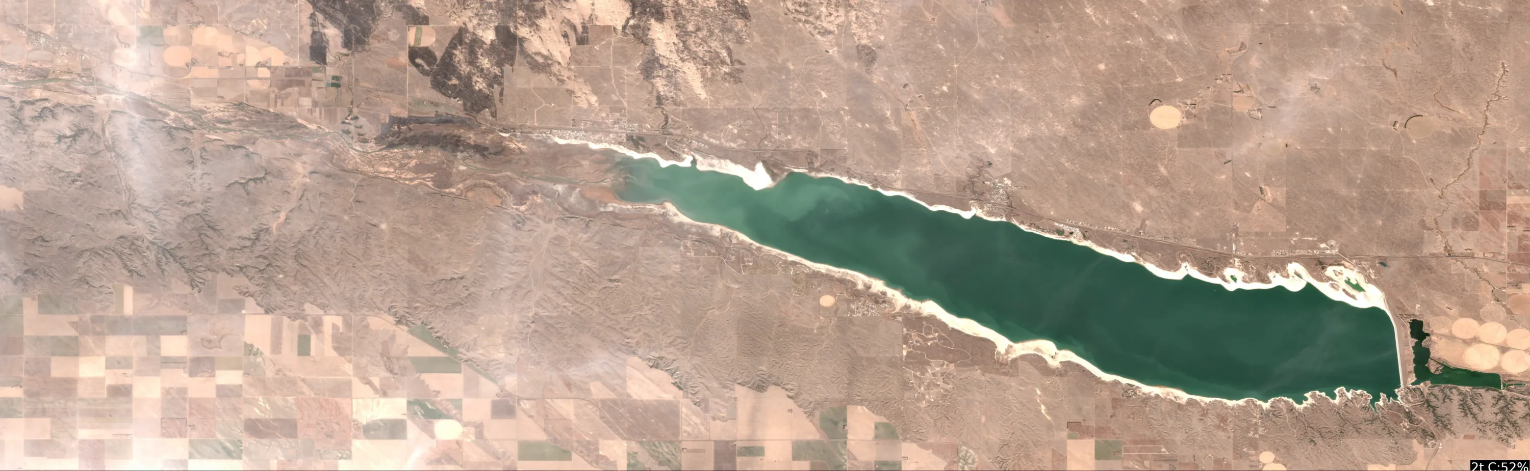
Analyze Satellite Imagery
Lake McConaughy Satellite Analysis - January 03, 2026 (Winter Conditions, 33°F)
1. LAKE OVERVIEW (Natural Sections & Landmarks)
Lake McConaughy is a long, narrow north-south reservoir, roughly 20 miles long and 3-4 miles wide at its broadest, with a large central main lake body flanked by shallower northern and southern sections.
- Main lake body: The expansive central open water area, deepest blues visible, stretching from mid-lake north-south.
- Northern section/arm: Shallower extension to the north, narrowing toward the North Platte River inflow, with tan/light blue flats along shores.
- Southern section/arm: Narrower basin south of the main body, leading to Kingsley Dam, with more enclosed coves and points.
- Major creek arms: Eastern shore features like Martin Bay (creek-like indentation) and Arthur Bay; western shore has smaller bays near Cedar Vue.
- Upper lake vs lower lake: Upper (northern) end near river inflow is more riverine with flats; lower (southern) near dam has steeper shorelines.
Major landmarks visible:
- Kingsley Dam (southern tip, prominent concrete structure with spillway).
- Big Mac Marina (west-central shore, cluster of docks and boat slips in main body).
- Arthur State Recreation Area boat ramp (east shore, northern main body, visible ramp and parking).
- Cedar Vue State Recreation Area (west shore, northern section, ramp and campground).
- Lone Eagle Memorial Boat Ramp (west shore, central main body, near marina).
- Johnson Bridge area (narrow central constriction visible as road crossing east side). No large islands dominate, but small points and peninsulas extend into the main body.
The lake divides naturally at the central narrows near Johnson Bridge (east) and Big Mac Marina (west), separating northern shallows from southern basin.
2. FINDABLE FISHING SPOTS
Identified 6 high-priority spots based on visible structure (points, color transitions), cover (docks, shorelines), and winter patterns (deep transitions near channels/points). Prioritized for walleye (wind-blown points, deep edges) and bass/catfish (structure with cover). All spots rated 1-10 using criteria: structure/cover (max points), depth transitions (color shifts), seasonal fit (deep refuge), wind exposure.
Northern Section
-
General Area: Northern section - main point near Cedar Vue boat ramp.
How to Find It: Launch at Cedar Vue ramp (west shore), head east across bay to the large protruding point on opposite (east) shoreline.
What You See: Bold point extending into light-to-medium blue transition; cluster of houses/docks at base; tan flats adjacent.
Why Fish It: Point creates current break and drop-off (sharp color line) for walleye staging in channels; adjacent flats for pre-spawn catfish (rating: 8/10 - strong structure, winter deep edge).
Best Approach: Troll or jig along color break from point tip toward deeper main lake. -
General Area: Northern section - creek mouth near North Platte inflow.
How to Find It: From Cedar Vue ramp, go north up the arm to where shoreline narrows and tan flats pinch in from east (visible river-like channel line).
What You See: Dark linear channel snaking from northeast shore into tan shallows; subtle color gradient to medium blue offshore.
Why Fish It: Creek channel bend holds winter walleye/catfish migrating from river; deep refuge off flats (rating: 7/10 - channel structure, seasonal migration path).
Best Approach: Anchor in channel eddy, vertical jig or drift bait.
Main Lake Body
-
General Area: Main lake body - point east of Big Mac Marina.
How to Find It: Launch at Lone Eagle ramp (west shore), cross to east shore; first major point south of Arthur ramp, marked by cluster of docks.
What You See: Point juts west into dark blue; dock line along shore; sharp medium-to-dark blue transition at tip.
Why Fish It: Wind-blown point with dock cover ideal for walleye; drop-off for stripers/bass refuge (rating: 9/10 - complex structure/cover, high seasonal fit).
Best Approach: Drift/jig edges, focus windward side. -
General Area: Main lake body - narrows near Johnson Bridge.
How to Find It: From Big Mac Marina, head east to road/bridge crossing visible on east shoreline; fish the pinch point below it.
What You See: Shoreline neck-down with dark water funneling through; points on both sides with color shifts.
Why Fish It: Constriction concentrates flow for channel catfish/flatheads; deep bends for walleye (rating: 8/10 - funnel structure, depth access).
Best Approach: Troll through narrows, target inside bends.
Southern Section
-
General Area: Southern section - cove north of Kingsley Dam.
How to Find It: From main body, head south past west shoreline houses to first protected cove just north of dam (visible concrete structure ahead).
What You See: Enclosed cove with docks on west arm; tan flats to medium blue drop near point; laydown-like lines from shore.
Why Fish It: Steep bank drop-off with dock cover for pre-spawn bass/walleye; thermal refuge near dam outflow (rating: 9/10 - cover density, transition).
Best Approach: Cast jigs to dock edges and laydowns. -
General Area: Southern section - eastern shore point by Arthur Bay.
How to Find It: From Arthur ramp (east shore), head south down eastern arm to prominent point guarding bay mouth.
What You See: Point with houses; dark patch suggesting brush/veggie near base; blue gradient offshore.
Why Fish It: Bay mouth point with potential creek channel for migrating fish; wind protection (rating: 7/10 - point + cover combo).
Best Approach: Fan-cast from point into bay transition.
3. VISIBLE FEATURES BY LAKE SECTION
Northern section: Cedar Vue ramp (west, campground); east shore points with docks; North Platte channel (northeast flats pinch); tan spawning flats along both shores.
Main lake body: Big Mac Marina (west-central docks); Lone Eagle ramp (west); Arthur ramp (east); Johnson Bridge narrows (east constriction); multiple points with dock clusters on east/west shores; central dark blue expanse.
Southern section: Kingsley Dam (south end); west shore coves with houses/docks; eastern Arthur Bay indentation; points with laydowns/shadows.
Eastern arms: Martin/Arthur Bays (indented creeks with points); ramp-accessible shores.
Western arms: Bays near Cedar Vue/Lone Eagle with ramp protection.
4. PRACTICAL FISHING GUIDANCE
Suggested fishing progression (winter, low light/33°F - focus deep transitions early, move shallow if warming):
- Start (dawn): Northern section - Cedar Vue point (launch easy, quick deep access).
- Mid-morning: Move to main lake body - Big Mac east point (follow shore south ~2 miles, wind-blown).
- Pattern: Northern shallows/channels early for staging fish → main lake points midday for offshore → southern coves late for refuge. Target walleye on points, catfish in channels.
Navigation between sections:
- Northern to main: South from Cedar Vue across bay, past Lone Eagle ramp.
- Main to southern: South through central blues, skirt west shore past marina or east past bridge narrows.
- All ramps visible/accessible; hug shorelines for wind protection in narrows.
Think boat angler: Use these landmarks to GPS-plot, then watch for color breaks on your graph. Tight lines!
Findings:
-
Lake McConaughy Satellite Analysis - January 03, 2026 (Winter Conditions, 33°F)
1. LAKE OVERVIEW (Natural Sections & Landmarks)
Lake McConaughy is a long, narrow north-south reservoir, roughly 20 miles long and 3-4 miles wide at its broadest, with a large central main lake body flanked by shallower northern and southern sections.
- Main lake body: The expansive central open water area, deepest blues visible, stretching from mid-lake north-south.
- Northern section/arm: Shallower extension to the north, narrowing toward the North Platte River inflow, with tan/light blue flats along shores.
- Southern section/arm: Narrower basin south of the main body, leading to Kingsley Dam, with more enclosed coves and points.
- Major creek arms: Eastern shore features like Martin Bay (creek-like indentation) and Arthur Bay; western shore has smaller bays near Cedar Vue.
- Upper lake vs lower lake: Upper (northern) end near river inflow is more riverine with flats; lower (southern) near dam has steeper shorelines.
Major landmarks visible:
- Kingsley Dam (southern tip, prominent concrete structure with spillway).
- Big Mac Marina (west-central shore, cluster of docks and boat slips in main body).
- Arthur State Recreation Area boat ramp (east shore, northern main body, visible ramp and parking).
- Cedar Vue State Recreation Area (west shore, northern section, ramp and campground).
- Lone Eagle Memorial Boat Ramp (west shore, central main body, near marina).
- Johnson Bridge area (narrow central constriction visible as road crossing east side). No large islands dominate, but small points and peninsulas extend into the main body.
The lake divides naturally at the central narrows near Johnson Bridge (east) and Big Mac Marina (west), separating northern shallows from southern basin.
2. FINDABLE FISHING SPOTS
Identified 6 high-priority spots based on visible structure (points, color transitions), cover (docks, shorelines), and winter patterns (deep transitions near channels/points). Prioritized for walleye (wind-blown points, deep edges) and bass/catfish (structure with cover). All spots rated 1-10 using criteria: structure/cover (max points), depth transitions (color shifts), seasonal fit (deep refuge), wind exposure.
Northern Section
-
General Area: Northern section - main point near Cedar Vue boat ramp.
How to Find It: Launch at Cedar Vue ramp (west shore), head east across bay to the large protruding point on opposite (east) shoreline.
What You See: Bold point extending into light-to-medium blue transition; cluster of houses/docks at base; tan flats adjacent.
Why Fish It: Point creates current break and drop-off (sharp color line) for walleye staging in channels; adjacent flats for pre-spawn catfish (rating: 8/10 - strong structure, winter deep edge).
Best Approach: Troll or jig along color break from point tip toward deeper main lake. -
General Area: Northern section - creek mouth near North Platte inflow.
How to Find It: From Cedar Vue ramp, go north up the arm to where shoreline narrows and tan flats pinch in from east (visible river-like channel line).
What You See: Dark linear channel snaking from northeast shore into tan shallows; subtle color gradient to medium blue offshore.
Why Fish It: Creek channel bend holds winter walleye/catfish migrating from river; deep refuge off flats (rating: 7/10 - channel structure, seasonal migration path).
Best Approach: Anchor in channel eddy, vertical jig or drift bait.
Main Lake Body
-
General Area: Main lake body - point east of Big Mac Marina.
How to Find It: Launch at Lone Eagle ramp (west shore), cross to east shore; first major point south of Arthur ramp, marked by cluster of docks.
What You See: Point juts west into dark blue; dock line along shore; sharp medium-to-dark blue transition at tip.
Why Fish It: Wind-blown point with dock cover ideal for walleye; drop-off for stripers/bass refuge (rating: 9/10 - complex structure/cover, high seasonal fit).
Best Approach: Drift/jig edges, focus windward side. -
General Area: Main lake body - narrows near Johnson Bridge.
How to Find It: From Big Mac Marina, head east to road/bridge crossing visible on east shoreline; fish the pinch point below it.
What You See: Shoreline neck-down with dark water funneling through; points on both sides with color shifts.
Why Fish It: Constriction concentrates flow for channel catfish/flatheads; deep bends for walleye (rating: 8/10 - funnel structure, depth access).
Best Approach: Troll through narrows, target inside bends.
Southern Section
-
General Area: Southern section - cove north of Kingsley Dam.
How to Find It: From main body, head south past west shoreline houses to first protected cove just north of dam (visible concrete structure ahead).
What You See: Enclosed cove with docks on west arm; tan flats to medium blue drop near point; laydown-like lines from shore.
Why Fish It: Steep bank drop-off with dock cover for pre-spawn bass/walleye; thermal refuge near dam outflow (rating: 9/10 - cover density, transition).
Best Approach: Cast jigs to dock edges and laydowns. -
General Area: Southern section - eastern shore point by Arthur Bay.
How to Find It: From Arthur ramp (east shore), head south down eastern arm to prominent point guarding bay mouth.
What You See: Point with houses; dark patch suggesting brush/veggie near base; blue gradient offshore.
Why Fish It: Bay mouth point with potential creek channel for migrating fish; wind protection (rating: 7/10 - point + cover combo).
Best Approach: Fan-cast from point into bay transition.
3. VISIBLE FEATURES BY LAKE SECTION
Northern section: Cedar Vue ramp (west, campground); east shore points with docks; North Platte channel (northeast flats pinch); tan spawning flats along both shores.
Main lake body: Big Mac Marina (west-central docks); Lone Eagle ramp (west); Arthur ramp (east); Johnson Bridge narrows (east constriction); multiple points with dock clusters on east/west shores; central dark blue expanse.
Southern section: Kingsley Dam (south end); west shore coves with houses/docks; eastern Arthur Bay indentation; points with laydowns/shadows.
Eastern arms: Martin/Arthur Bays (indented creeks with points); ramp-accessible shores.
Western arms: Bays near Cedar Vue/Lone Eagle with ramp protection.
4. PRACTICAL FISHING GUIDANCE
Suggested fishing progression (winter, low light/33°F - focus deep transitions early, move shallow if warming):
- Start (dawn): Northern section - Cedar Vue point (launch easy, quick deep access).
- Mid-morning: Move to main lake body - Big Mac east point (follow shore south ~2 miles, wind-blown).
- Pattern: Northern shallows/channels early for staging fish → main lake points midday for offshore → southern coves late for refuge. Target walleye on points, catfish in channels.
Navigation between sections:
- Northern to main: South from Cedar Vue across bay, past Lone Eagle ramp.
- Main to southern: South through central blues, skirt west shore past marina or east past bridge narrows.
- All ramps visible/accessible; hug shorelines for wind protection in narrows.
Think boat angler: Use these landmarks to GPS-plot, then watch for color breaks on your graph. Tight lines!
Analyze Pressure Trends
Barometric pressure analysis for Lake McConaughy: rising trend at 1005.00mb
Findings:
- Rising pressure trend (1005.00 → higher). Bite may slow down as fish become less active.
- Switch to finesse tactics, target deeper structure. Fish will be less aggressive.
Analyze Thermal Patterns
Overall Thermal Landscape Summary
Assuming North is at the top of the image, East to the right, West to the left, and South at the bottom (standard orientation for satellite imagery unless otherwise marked). The lake appears irregularly shaped with a somewhat elongated form trending northwest-southeast, featuring a prominent narrow inlet or channel entering from the top-left (NW) area and a broader main basin occupying most of the central and eastern portions. No major islands, peninsulas, or distinct C-shaped bays are clearly visible as anchors; the shoreline is mostly jagged but lacks standout geometric features like sharp points or U-shaped coves. Dominant visual is uniform dark shading across water areas (rendering as solid █ blocks in this text representation), with no discernible color variations. Approximate min/max temperatures cannot be determined due to lack of visible color differentiation matching the provided thermal scale—all water areas appear uniformly dark, suggesting very low resolution or monochromatic rendering preventing color-based analysis. Image quality is insufficient for precise thermal pattern identification; no clear water vs. land distinction or temperature gradients observable.
Detailed Thermal Feature Analysis
Temperature Breaks: No clearly visible boundaries between different colored areas; the entire water body renders as uniform dark █ shading with no abrupt or gradual color transitions detectable.
Pockets/Patches: No isolated pockets, patches, or distinct color clusters (e.g., no cyan, green, yellow, or orange areas) visible; all water appears homogeneously dark.
Gradients: No gradual color transitions observable; shading is blocky and uniform without tonal shifts.
Uniform Areas: The main lake basin (entire central to eastern water mass, from the NW inlet to the SE extent) shows consistent dark █ rendering across all identifiable water areas. Without color mapping to the scale, temperature range cannot be specified; land areas (surrounding edges) are indistinguishable from water in this representation. Significance limited—uniformity suggests either consistent surface temperatures or image rendering limitations preventing analysis.
Insightful Fish Behavior Interpretation
Due to the lack of visible thermal variations or color distinctions, no specific fish behavior patterns can be reliably interpreted from surface temperatures. Fish may be distributed uniformly across the lake if surface conditions are homogeneous, with activity levels unknown without temperature data. Surface feeding or shallow activity cannot be linked to any observed patterns, as no warmer/cooler zones, transitions, or preferences are evident.
Satellite Correlation Analysis
No additional satellite imagery (e.g., visible light or topographic data) is provided alongside the thermal image. The NW narrow inlet could potentially align with an inflow if correlated with external data, but no thermal signature (e.g., cooler intrusion) is visible to support this. No springs, wind-mixing zones, or surface structure relationships observable due to uniform rendering. Cannot explain thermal gradients, as none are present.
Actionable Fishing Recommendations
Image quality and lack of color differentiation prevent hyper-specific, actionable intelligence; analysis is severely limited to general advice. Focus efforts uniformly across the lake, prioritizing the main basin and NW inlet area for exploration, as no thermal hotspots, breaks, or preferences are visible. Use surface lures or shallow tactics broadly, monitoring local conditions (e.g., wind, time of day) since satellite data shows no surface temperature-driven patterns. Recommend ground-truthing with on-site thermometer or forward-facing sonar for real-time surface temps, as this thermal representation yields no fishable insights.
Findings:
- Current surface temperature: 33.0°F. Fish metabolism significantly reduced in cold water. Target sunny, protected shorelines and use extremely slow presentations. Focus on midday when surface temperatures are warmest.
-
Overall Thermal Landscape Summary
Assuming North is at the top of the image, East to the right, West to the left, and South at the bottom (standard orientation for satellite imagery unless otherwise marked). The lake appears irregularly shaped with a somewhat elongated form trending northwest-southeast, featuring a prominent narrow inlet or channel entering from the top-left (NW) area and a broader main basin occupying most of the central and eastern portions. No major islands, peninsulas, or distinct C-shaped bays are clearly visible as anchors; the shoreline is mostly jagged but lacks standout geometric features like sharp points or U-shaped coves. Dominant visual is uniform dark shading across water areas (rendering as solid █ blocks in this text representation), with no discernible color variations. Approximate min/max temperatures cannot be determined due to lack of visible color differentiation matching the provided thermal scale—all water areas appear uniformly dark, suggesting very low resolution or monochromatic rendering preventing color-based analysis. Image quality is insufficient for precise thermal pattern identification; no clear water vs. land distinction or temperature gradients observable.
Detailed Thermal Feature Analysis
Temperature Breaks: No clearly visible boundaries between different colored areas; the entire water body renders as uniform dark █ shading with no abrupt or gradual color transitions detectable.
Pockets/Patches: No isolated pockets, patches, or distinct color clusters (e.g., no cyan, green, yellow, or orange areas) visible; all water appears homogeneously dark.
Gradients: No gradual color transitions observable; shading is blocky and uniform without tonal shifts.
Uniform Areas: The main lake basin (entire central to eastern water mass, from the NW inlet to the SE extent) shows consistent dark █ rendering across all identifiable water areas. Without color mapping to the scale, temperature range cannot be specified; land areas (surrounding edges) are indistinguishable from water in this representation. Significance limited—uniformity suggests either consistent surface temperatures or image rendering limitations preventing analysis.
Insightful Fish Behavior Interpretation
Due to the lack of visible thermal variations or color distinctions, no specific fish behavior patterns can be reliably interpreted from surface temperatures. Fish may be distributed uniformly across the lake if surface conditions are homogeneous, with activity levels unknown without temperature data. Surface feeding or shallow activity cannot be linked to any observed patterns, as no warmer/cooler zones, transitions, or preferences are evident.
Satellite Correlation Analysis
No additional satellite imagery (e.g., visible light or topographic data) is provided alongside the thermal image. The NW narrow inlet could potentially align with an inflow if correlated with external data, but no thermal signature (e.g., cooler intrusion) is visible to support this. No springs, wind-mixing zones, or surface structure relationships observable due to uniform rendering. Cannot explain thermal gradients, as none are present.
Actionable Fishing Recommendations
Image quality and lack of color differentiation prevent hyper-specific, actionable intelligence; analysis is severely limited to general advice. Focus efforts uniformly across the lake, prioritizing the main basin and NW inlet area for exploration, as no thermal hotspots, breaks, or preferences are visible. Use surface lures or shallow tactics broadly, monitoring local conditions (e.g., wind, time of day) since satellite data shows no surface temperature-driven patterns. Recommend ground-truthing with on-site thermometer or forward-facing sonar for real-time surface temps, as this thermal representation yields no fishable insights.
- Winter surface patterns: Target the warmest surface areas during midday, typically along north-facing shorelines and sun-exposed areas. Use slow presentations as fish metabolism is reduced.
Analyze Species Behavior
Species behavior analysis for Lake McConaughy completed
Findings:
- Walleye: Cold water active (33.0°F), target deep edges with live bait or slow jigs
- White bass: Sluggish in cold water (33.0°F), target deep structure with slow presentations
- Striped bass: Sluggish in cold water (33.0°F), target deep structure with slow presentations
- Walleye: sluggish activity at 33.0°F (optimal: 45-65°F)
- White bass: sluggish activity at 33.0°F (optimal: 60-75°F)
How this was synthesized
Professional fishing guide analysis integrating 10 tools: lure_matrix_wind_clarity, analyze_solunar_timing, analyze_hourly_conditions, analyze_water_clarity, analyze_weather_conditions, analyze_satellite_imagery, analyze_pressure_trends, analyze_thermal_patterns, analyze_species_behavior, get_community_reports. User request: 'Generate a comprehensive fishing report for Lake McConaughy. Use tools to analyze satellite structure, thermal patterns, water clarity, weather, and solunar timing, then synthesize a concise plan.'. Synthesis generated comprehensive plan with professional recommendations.