Lake Hudson (Markham Ferry Reservoir) Fishing Report
Synthesis generated comprehensive plan with professional recommendations.
Lake Hudson (Markham Ferry Reservoir) Fishing Report
Generated Feb 14, 2026, 12:57 AM.
Key fishing read
- Max thump: giant spinnerbaits, slow roll, contact cover
- Day 5: new - increased fish activity expected, especially at night
- Plan trips around major solunar periods for peak activity, minor periods offer secondary opportunities
- Day 1: High pressure (1018mb) - tougher bite, use finesse tactics
- Day 1: High winds (20mph) - seek protected areas, use heavier lures
- Day 1: Rain, High: 71°F, Low: 42°F
- Day 2: High pressure (1011mb) - tougher bite, use finesse tactics
- Day 2: High winds (32mph) - seek protected areas, use heavier lures
Tool analysis details
Estimate Seasonal Phase
No historical temperature data for Lake Hudson (Markham Ferry Reservoir)
Lure Matrix Wind Clarity
Lure guidance for wind=windy, clarity=unknown.
Findings:
- Max thump: giant spinnerbaits, slow roll, contact cover
Analyze Solunar Timing
Solunar timing analysis for Lake Hudson (Markham Ferry Reservoir) completed
Findings:
- Day 5: new - increased fish activity expected, especially at night
- Plan trips around major solunar periods for peak activity, minor periods offer secondary opportunities
Analyze Weather Conditions
Weather analysis for Lake Hudson (Markham Ferry Reservoir) completed
Findings:
- Day 1: High pressure (1018mb) - tougher bite, use finesse tactics
- Day 1: High winds (20mph) - seek protected areas, use heavier lures
- Day 1: Rain, High: 71°F, Low: 42°F
- Day 2: High pressure (1011mb) - tougher bite, use finesse tactics
- Day 2: High winds (32mph) - seek protected areas, use heavier lures
Analyze Species Behavior
Species behavior analysis for Lake Hudson (Markham Ferry Reservoir) completed
Findings:
- Largemouth bass: Sluggish in cold water (39.0°F), target deep structure with slow presentations
- Smallmouth bass: Sluggish in cold water (39.0°F), target deep structure with slow presentations
- Spotted bass: Sluggish in cold water (39.0°F), target deep structure with slow presentations
- White bass: Sluggish in cold water (39.0°F), target deep structure with slow presentations
- Largemouth bass: sluggish activity at 39.0°F (optimal: 60-75°F)
Analyze Pressure Trends
Barometric pressure analysis for Lake Hudson (Markham Ferry Reservoir): falling trend at 1018.00mb
Findings:
- Falling pressure trend detected (1018.00 → lower). Fish will be more active - excellent feeding windows ahead!
- Target shallow areas, use aggressive presentations. Fish are actively feeding.
Analyze Thermal Patterns
Overall Thermal Landscape Summary
Assuming North is at the top of the image, East to the right, South at the bottom, and West to the left. The image appears to depict a irregularly shaped lake body, primarily represented by large open whitespace areas (interpreted as water), with scattered small clusters of dots (.) suggesting minor visual disruptions or artifacts, and more defined land-like structures (clusters of [, ], ^ characters) concentrated in the bottom-right (SE) corner, including labels like "49°" and "66°" which may indicate coordinates or metadata but not thermal data. No discernible colors from the provided thermal scale (e.g., no navy blue, green, yellow, orange, or red hues) are visible in the provided representation, which is rendered entirely in monochromatic ASCII text characters. Dominant "pattern" is uniform whitespace across ~90% of the area. Approximate min/max temperatures cannot be determined due to absence of matching color patterns; image quality prevents thermal analysis.
Detailed Thermal Feature Analysis
Temperature Breaks: No clearly visible boundaries between different colored thermal zones, as no colors are present. The transitions from whitespace (water) to clustered characters (likely land in SE corner) show abrupt shifts but no thermal color gradients.
Pockets/Patches: Scattered small clusters of dots (e.g., isolated groups of 2-5 dots in the upper half, central area, and mid-right side) may represent minor visual anomalies, but without color distinction, no temperature pockets can be identified or matched to the scale.
Gradients: No gradual or abrupt color transitions observable; the entire water area (whitespace) appears uniform without shading or color variation.
Uniform Areas: The vast majority of the image (~central 80-90%, from top to bottom third excluding SE land clusters) consists of consistent whitespace, indicating no detectable surface temperature variations. SE corner land areas (dense character clusters around "49°" label) are ignored per instructions, as they represent non-water terrain.
Insightful Fish Behavior Interpretation
Without visible thermal color variations or temperature ranges, no specific surface temperature-based fish behavior can be inferred. Fish are likely distributed uniformly across the surface water if no thermal drivers are present, with general surface feeding possible in shallow areas. Temperature breaks or warmer/cooler zones—which typically attract fish for comfort and feeding—are not detectable here, suggesting neutral conditions where fish may hold in typical structure rather than thermal edges.
Satellite Correlation Analysis
No additional satellite imagery (e.g., visible light photos) is provided alongside the thermal data. The visible SE land structures (jagged [ ^ ] shapes near "49°") align with shoreline boundaries, but without thermal colors or structural details like inlets/points in water areas, no correlations to inflows, springs, or wind-mixing can be made. Thermal uniformity in water suggests no surface-influenced gradients from visible features.
Actionable Fishing Recommendations
Due to the lack of discernible thermal colors or patterns in the provided image, no hyper-specific, actionable spots based on surface temperature can be recommended—focus on general lake exploration using non-thermal methods (e.g., sonar for structure, known access points). Target open water areas away from the SE land clusters for surface trolling or casting, as uniformity implies no thermal-driven concentrations. If a full-color thermal image becomes available, re-analysis would enable precise break-line targeting. Prioritize dawn/dusk for surface activity regardless of undifferentiated temps.
Findings:
- Current surface temperature: 39.0°F. Fish metabolism significantly reduced in cold water. Target sunny, protected shorelines and use extremely slow presentations. Focus on midday when surface temperatures are warmest.
-
Overall Thermal Landscape Summary
Assuming North is at the top of the image, East to the right, South at the bottom, and West to the left. The image appears to depict a irregularly shaped lake body, primarily represented by large open whitespace areas (interpreted as water), with scattered small clusters of dots (.) suggesting minor visual disruptions or artifacts, and more defined land-like structures (clusters of [, ], ^ characters) concentrated in the bottom-right (SE) corner, including labels like "49°" and "66°" which may indicate coordinates or metadata but not thermal data. No discernible colors from the provided thermal scale (e.g., no navy blue, green, yellow, orange, or red hues) are visible in the provided representation, which is rendered entirely in monochromatic ASCII text characters. Dominant "pattern" is uniform whitespace across ~90% of the area. Approximate min/max temperatures cannot be determined due to absence of matching color patterns; image quality prevents thermal analysis.
Detailed Thermal Feature Analysis
Temperature Breaks: No clearly visible boundaries between different colored thermal zones, as no colors are present. The transitions from whitespace (water) to clustered characters (likely land in SE corner) show abrupt shifts but no thermal color gradients.
Pockets/Patches: Scattered small clusters of dots (e.g., isolated groups of 2-5 dots in the upper half, central area, and mid-right side) may represent minor visual anomalies, but without color distinction, no temperature pockets can be identified or matched to the scale.
Gradients: No gradual or abrupt color transitions observable; the entire water area (whitespace) appears uniform without shading or color variation.
Uniform Areas: The vast majority of the image (~central 80-90%, from top to bottom third excluding SE land clusters) consists of consistent whitespace, indicating no detectable surface temperature variations. SE corner land areas (dense character clusters around "49°" label) are ignored per instructions, as they represent non-water terrain.
Insightful Fish Behavior Interpretation
Without visible thermal color variations or temperature ranges, no specific surface temperature-based fish behavior can be inferred. Fish are likely distributed uniformly across the surface water if no thermal drivers are present, with general surface feeding possible in shallow areas. Temperature breaks or warmer/cooler zones—which typically attract fish for comfort and feeding—are not detectable here, suggesting neutral conditions where fish may hold in typical structure rather than thermal edges.
Satellite Correlation Analysis
No additional satellite imagery (e.g., visible light photos) is provided alongside the thermal data. The visible SE land structures (jagged [ ^ ] shapes near "49°") align with shoreline boundaries, but without thermal colors or structural details like inlets/points in water areas, no correlations to inflows, springs, or wind-mixing can be made. Thermal uniformity in water suggests no surface-influenced gradients from visible features.
Actionable Fishing Recommendations
Due to the lack of discernible thermal colors or patterns in the provided image, no hyper-specific, actionable spots based on surface temperature can be recommended—focus on general lake exploration using non-thermal methods (e.g., sonar for structure, known access points). Target open water areas away from the SE land clusters for surface trolling or casting, as uniformity implies no thermal-driven concentrations. If a full-color thermal image becomes available, re-analysis would enable precise break-line targeting. Prioritize dawn/dusk for surface activity regardless of undifferentiated temps.
- Winter surface patterns: Target the warmest surface areas during midday, typically along north-facing shorelines and sun-exposed areas. Use slow presentations as fish metabolism is reduced.
Analyze Water Clarity
1. Overall Water Quality Summary
The imagery reveals predominantly clear water conditions across Lake Hudson, dominated by dark blue/teal tones indicative of low sediment + low chlorophyll (bottom-left quadrant of the matrix), suggesting excellent visibility (15-25+ feet) in the main body. Scattered bright green patches (bottom-center: moderate chlorophyll + low sediment) add productive tinted zones (8-15 feet visibility), while isolated yellow/orange blotches and tan streaks (bottom-right/top-left transitions: high chlorophyll/low sediment or low chlorophyll/high sediment) introduce localized stained areas (2-8 feet visibility). No extreme top-right dark brown/red mixes are evident, indicating overall high water quality with minor turbidity and algae influences confined to peripheral spots.
2. Detailed Clarity Zone Mapping & Characterization (3-5 Key Zones with locations, categories, causes)
Zone 1: Northern Main Basin (Top/Central Image Area)
- Matrix Position Analysis: Predominant dark blue/teal (bottom-left quadrant).
- Combined Conditions: Low sediment + low chlorophyll = clearest water, 15-25+ feet visibility.
- Location Mapping: Covers the upper two-thirds of the image, centered in the north-central basin, extending west-to-east across the primary lake body.
- Tactical Implications: Premium sight-fishing; fish hold deep and visible, requiring stealthy approaches.
- Visual Cause: Stable deep water, minimal disturbance.
Zone 2: Eastern/Northeastern Scattered Patches (Upper Right)
- Matrix Position Analysis: Bright green spots/clusters (bottom-center quadrant).
- Combined Conditions: Moderate chlorophyll + low sediment = productive clear-tinted water, 8-15 feet visibility.
- Location Mapping: Discrete flecks and small clusters along the northeastern shoreline and upper eastern arm, approximately 20-30% of the northern section.
- Tactical Implications: Algae-tinted but clear; good for suspended fish near surface structure.
- Visual Cause: Localized algae growth in shallower northeast bays.
Zone 3: Southern Blotches (Lower Central/Bottom)
- Matrix Position Analysis: Yellow/orange streaks and patches (bottom-right quadrant).
- Combined Conditions: High chlorophyll + low sediment = algae-stained clear base, 3-8 feet visibility.
- Location Mapping: Concentrated in the lower third, central-southern flats, with streaks radiating northward from the bottom edge.
- Tactical Implications: Reaction strikes at edges; vibration needed to penetrate tint.
- Visual Cause: Algae blooms in wind-exposed southern shallows.
Zone 4: Southwestern Tan Streaks (Lower Left)
- Matrix Position Analysis: Tan/orange irregular streaks (top-left quadrant transitioning to center).
- Combined Conditions: Low chlorophyll + high sediment = muddy runoff zones, 2-6 feet visibility.
- Location Mapping: Scattered along the lower left (southwest) margin, forming finger-like extensions into the central basin.
- Tactical Implications: Power fishing essential; fish tight to structure in low light.
- Visual Cause: Sediment stirring from southern/western inflows or wind-blown banks.
Transition Zone Note: All zones show gradual edges where dark blue meets green/yellow/tan, marking high-productivity lines.
3. Turbidity/Algae Sources & Transition Zones Analysis
Source Identification (Visual): Tan/orange streaks in the southwest/south (lower left/bottom) suggest high-sediment inputs from probable creek inflows or wind-stirred shallows along the southern perimeter. Bright green and yellow/orange patches in the northeast/south (upper right/lower center) indicate chlorophyll hotspots from nutrient-rich coves or protected shallows fostering algae. No widespread dark brown/red extremes, limiting severe turbidity.
Clarity Breaks/Edges: Gradual transitions dominate—e.g., a diffuse blue-to-green shift along northeastern patches (algae edges, high baitfish potential); sharp tan streaks cutting into southern blue zones forming "mudlines" (sediment walls, ambush points); yellow blotches feathering northward into central teal (algae fronts). These edges, visible as color gradients (10-20% of image area), concentrate prey and predators, offering prime fishing for reaction bites where clarity changes trigger feeding.
4. Species-Specific Clarity Strategy (Recommendations tied to zones)
- Largemouth Bass: Target Zone 1 (northern main basin, dark blue/teal) for deep-holding fish in ultra-clear water; patrol Zone 3 southern yellow/orange edges (high chlorophyll) for ambush from algae-stained shallows.
- Crappie: Suspend in Zone 2 eastern/northeastern green patches (moderate chlorophyll, 8-15 ft visibility), near visible cover; finesse the blue-green transitions in north-central areas.
- Walleye/Catfish: Hug Zone 4 southwestern tan streaks (high sediment, low light) in southern shallows, where muddy conditions favor bottom-feeders; catfish stage at tan-blue clarity breaks along southwest margins.
- General: Bass and crappie favor clear Zone 1/2 interiors, shifting to edges of Zones 3/4 during low light; use compass-aligned drifts (e.g., north-south along eastern green zones) to intersect transitions.
5. Tactical Fishing Adjustments (Lures/Presentations tied to zones)
Zone 1 (Dark Blue/Teal, Clear): Natural colors (green pumpkin, shad, watermelon seed) on finesse jigs, drop shots, or small swimbaits; slow retrieves with pauses; long casts (40+ yards), fluorocarbon 8-12lb, spot-on positioning 50+ yards off.
Zone 2 (Green, Tinted Clear): Mix natural/bright (chartreuse tails on green pumpkin soft plastics, suspending jerkbaits); moderate steady retrieves; 20-30 yard casts, 10-12lb fluoro/mono.
Zone 3 (Yellow/Orange, Algae-Stained): Bright/vibrant (chartreuse/white crankbaits, spinnerbaits with rattles); fast aggressive retrieves to trigger reactions; target edges with yo-yo action, 12-15lb line.
Zone 4 (Tan, Muddy): High-contrast/noise (black/blue jigs, chartreuse/orange lipless crankbaits, big worms with rattles); slow dragging with heavy vibration; short 10-20 yard casts, 15-20lb braid leadered to fluoro.
Clarity Breaks: Parallel casts along edges (e.g., fan-cast mudlines in Zone 4); alternate power (vibration) and finesse (slow scent) every 5-10 casts; downsize all by 25% for 39°F cold water sluggishness.
6. Seasonal Context (Interpretation of visual patterns)
The dominant dark blue/teal clarity across 70%+ of the lake, with only peripheral green/yellow/tan spots, appears resilient and stable, suggesting minimal recent disturbance despite cold 39°F temps—consistent with winter/early spring patterns where deep main basin water resists wind-mixing or inflows. Localized southern tan streaks and northeastern green patches indicate minor wind-blown sediment or sheltered algae persistence, not extreme blooms, pointing to typical low-activity conditions rather than post-storm turbidity; the persistent clear core implies reliable deep-water fishing havens.
Findings:
-
1. Overall Water Quality Summary
The imagery reveals predominantly clear water conditions across Lake Hudson, dominated by dark blue/teal tones indicative of low sediment + low chlorophyll (bottom-left quadrant of the matrix), suggesting excellent visibility (15-25+ feet) in the main body. Scattered bright green patches (bottom-center: moderate chlorophyll + low sediment) add productive tinted zones (8-15 feet visibility), while isolated yellow/orange blotches and tan streaks (bottom-right/top-left transitions: high chlorophyll/low sediment or low chlorophyll/high sediment) introduce localized stained areas (2-8 feet visibility). No extreme top-right dark brown/red mixes are evident, indicating overall high water quality with minor turbidity and algae influences confined to peripheral spots.
2. Detailed Clarity Zone Mapping & Characterization (3-5 Key Zones with locations, categories, causes)
Zone 1: Northern Main Basin (Top/Central Image Area)
- Matrix Position Analysis: Predominant dark blue/teal (bottom-left quadrant).
- Combined Conditions: Low sediment + low chlorophyll = clearest water, 15-25+ feet visibility.
- Location Mapping: Covers the upper two-thirds of the image, centered in the north-central basin, extending west-to-east across the primary lake body.
- Tactical Implications: Premium sight-fishing; fish hold deep and visible, requiring stealthy approaches.
- Visual Cause: Stable deep water, minimal disturbance.
Zone 2: Eastern/Northeastern Scattered Patches (Upper Right)
- Matrix Position Analysis: Bright green spots/clusters (bottom-center quadrant).
- Combined Conditions: Moderate chlorophyll + low sediment = productive clear-tinted water, 8-15 feet visibility.
- Location Mapping: Discrete flecks and small clusters along the northeastern shoreline and upper eastern arm, approximately 20-30% of the northern section.
- Tactical Implications: Algae-tinted but clear; good for suspended fish near surface structure.
- Visual Cause: Localized algae growth in shallower northeast bays.
Zone 3: Southern Blotches (Lower Central/Bottom)
- Matrix Position Analysis: Yellow/orange streaks and patches (bottom-right quadrant).
- Combined Conditions: High chlorophyll + low sediment = algae-stained clear base, 3-8 feet visibility.
- Location Mapping: Concentrated in the lower third, central-southern flats, with streaks radiating northward from the bottom edge.
- Tactical Implications: Reaction strikes at edges; vibration needed to penetrate tint.
- Visual Cause: Algae blooms in wind-exposed southern shallows.
Zone 4: Southwestern Tan Streaks (Lower Left)
- Matrix Position Analysis: Tan/orange irregular streaks (top-left quadrant transitioning to center).
- Combined Conditions: Low chlorophyll + high sediment = muddy runoff zones, 2-6 feet visibility.
- Location Mapping: Scattered along the lower left (southwest) margin, forming finger-like extensions into the central basin.
- Tactical Implications: Power fishing essential; fish tight to structure in low light.
- Visual Cause: Sediment stirring from southern/western inflows or wind-blown banks.
Transition Zone Note: All zones show gradual edges where dark blue meets green/yellow/tan, marking high-productivity lines.
3. Turbidity/Algae Sources & Transition Zones Analysis
Source Identification (Visual): Tan/orange streaks in the southwest/south (lower left/bottom) suggest high-sediment inputs from probable creek inflows or wind-stirred shallows along the southern perimeter. Bright green and yellow/orange patches in the northeast/south (upper right/lower center) indicate chlorophyll hotspots from nutrient-rich coves or protected shallows fostering algae. No widespread dark brown/red extremes, limiting severe turbidity.
Clarity Breaks/Edges: Gradual transitions dominate—e.g., a diffuse blue-to-green shift along northeastern patches (algae edges, high baitfish potential); sharp tan streaks cutting into southern blue zones forming "mudlines" (sediment walls, ambush points); yellow blotches feathering northward into central teal (algae fronts). These edges, visible as color gradients (10-20% of image area), concentrate prey and predators, offering prime fishing for reaction bites where clarity changes trigger feeding.
4. Species-Specific Clarity Strategy (Recommendations tied to zones)
- Largemouth Bass: Target Zone 1 (northern main basin, dark blue/teal) for deep-holding fish in ultra-clear water; patrol Zone 3 southern yellow/orange edges (high chlorophyll) for ambush from algae-stained shallows.
- Crappie: Suspend in Zone 2 eastern/northeastern green patches (moderate chlorophyll, 8-15 ft visibility), near visible cover; finesse the blue-green transitions in north-central areas.
- Walleye/Catfish: Hug Zone 4 southwestern tan streaks (high sediment, low light) in southern shallows, where muddy conditions favor bottom-feeders; catfish stage at tan-blue clarity breaks along southwest margins.
- General: Bass and crappie favor clear Zone 1/2 interiors, shifting to edges of Zones 3/4 during low light; use compass-aligned drifts (e.g., north-south along eastern green zones) to intersect transitions.
5. Tactical Fishing Adjustments (Lures/Presentations tied to zones)
Zone 1 (Dark Blue/Teal, Clear): Natural colors (green pumpkin, shad, watermelon seed) on finesse jigs, drop shots, or small swimbaits; slow retrieves with pauses; long casts (40+ yards), fluorocarbon 8-12lb, spot-on positioning 50+ yards off.
Zone 2 (Green, Tinted Clear): Mix natural/bright (chartreuse tails on green pumpkin soft plastics, suspending jerkbaits); moderate steady retrieves; 20-30 yard casts, 10-12lb fluoro/mono.
Zone 3 (Yellow/Orange, Algae-Stained): Bright/vibrant (chartreuse/white crankbaits, spinnerbaits with rattles); fast aggressive retrieves to trigger reactions; target edges with yo-yo action, 12-15lb line.
Zone 4 (Tan, Muddy): High-contrast/noise (black/blue jigs, chartreuse/orange lipless crankbaits, big worms with rattles); slow dragging with heavy vibration; short 10-20 yard casts, 15-20lb braid leadered to fluoro.
Clarity Breaks: Parallel casts along edges (e.g., fan-cast mudlines in Zone 4); alternate power (vibration) and finesse (slow scent) every 5-10 casts; downsize all by 25% for 39°F cold water sluggishness.
6. Seasonal Context (Interpretation of visual patterns)
The dominant dark blue/teal clarity across 70%+ of the lake, with only peripheral green/yellow/tan spots, appears resilient and stable, suggesting minimal recent disturbance despite cold 39°F temps—consistent with winter/early spring patterns where deep main basin water resists wind-mixing or inflows. Localized southern tan streaks and northeastern green patches indicate minor wind-blown sediment or sheltered algae persistence, not extreme blooms, pointing to typical low-activity conditions rather than post-storm turbidity; the persistent clear core implies reliable deep-water fishing havens.
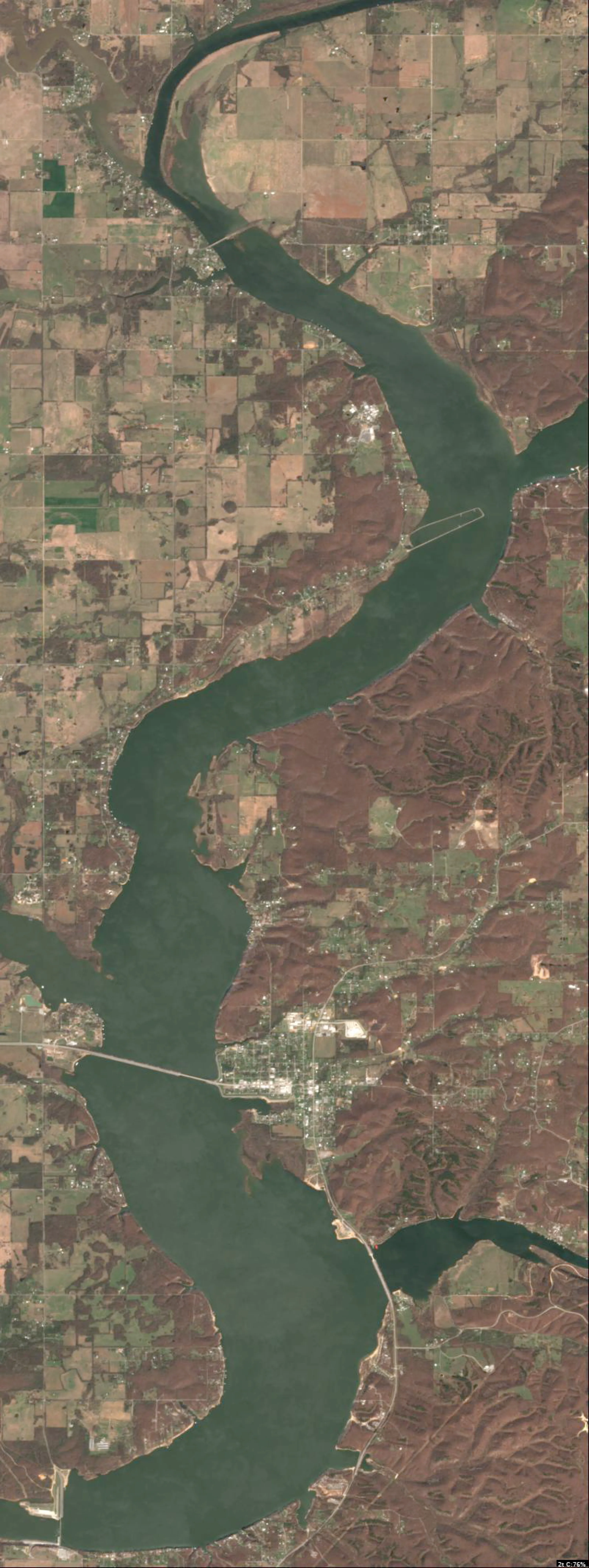
Analyze Satellite Imagery
Lake Hudson (Markham Ferry Reservoir) Satellite Analysis
1. LAKE OVERVIEW (Natural Sections & Landmarks)
The lake has an irregular, elongated shape oriented roughly north-south, with a narrow northern section transitioning into a wider main lake body in the center, and a broader southern section that flares out with multiple coves.
- Main lake body: Central open water area, widest in the middle with protruding points on both shorelines.
- Northern section/arm: Narrow inlet-like arm extending north, with irregular shorelines and small indents suggesting coves.
- Southern section/arm: Wider expanse south of the main body, divided by small islands and with extended shorelines forming multiple bays.
- Major creek arms: Eastern shore has a distinct inlet arm in the northern section; southern section shows a western inlet arm.
- Upper lake vs lower lake: Upper (northern) lake is narrower and more sheltered; lower (southern/main) lake is open and expansive.
Major landmarks visible:
- Boat ramp: Straight path-like line extending from the western shore into the main lake body (mid-center).
- Marina/dock clusters: Dense group of linear features (docks) on the northeastern shore of the main body.
- Bridge-like crossing: Horizontal line spanning a narrow neck in the northern section.
- Small islands: Two compact irregular shapes in the southern section—one central, one off the eastern shore.
- Dam area: Straight southern boundary line at the very bottom.
The lake divides naturally at the narrow neck in the northern section (bridge area) and around the central islands in the southern section.
2. FINDABLE FISHING SPOTS
Here are 6 high-priority, findable spots based on visible shoreline geometry, points, docks, inlets, and color-like transitions (lighter irregular patches near shore vs darker central water). Prioritized for winter/pre-spawn (39°F): points with adjacent shallows, channel-like inlets, and dock cover near transitions. Rated 1-10 using structure/cover complexity, depth transition hints (color shifts), seasonal fit, and wind protection.
-
General Area: Northern section
How to Find It: From the northern bridge, head south along the eastern shore to the first major protruding point with a dock cluster.
What You See: Protruding point with adjacent docks (linear shadows) and a sharp shoreline turn into darker water.
Why Fish It: Point offers structure transition; docks provide cover for bass staging in channels during cold water (priority for largemouth/spotted bass). Priority: 9/10 (high structure + cover combo, sheltered).
Best Approach: Cast jigs or suspending jerkbaits along the point edge and under docks. -
General Area: Main lake body
How to Find It: Locate the boat ramp on the western shore, then go east across to the large northeastern dock cluster on the point.
What You See: Dense rectangular dock group on a broad point extending into open water, with lighter shallows transitioning to darker center.
Why Fish It: Dock-covered point with transition = winter bass refuge; good for catfish near structure (largemouth/channel catfish target). Priority: 10/10 (max cover density + exposure).
Best Approach: Parallel the docks with slow crankbaits or drop-shot rigs; fan-cast the point tip. -
General Area: Northern section
How to Find It: North of the bridge, follow the eastern inlet (creek arm) to where it meets the main shoreline point.
What You See: Serpentine inlet line leading to a shoreline point with irregular light patches (possible flats).
Why Fish It: Creek channel bend with point = pre-spawn migration path; deep refuge adjacent to shallows (bass, crappie in brush-like clusters). Priority: 8/10 (strong channel structure, seasonal fit).
Best Approach: Drag worms or spoons along the channel edge into the point. -
General Area: Southern section
How to Find It: From the main lake boat ramp, head south past the central island to the eastern shore cove behind it.
What You See: Protected cove with shoreline indent, docks, and small dark clusters (brush/standing timber hints) near the island.
Why Fish It: Island-adjacent cove with cover = wind-protected winter holdover; crappie/bass on docks and clusters. Priority: 9/10 (cover density + protection).
Best Approach: Vertically jig minnows under docks or around clusters; skirt the island edge. -
General Area: Main lake body - southern edge
How to Find It: From the northeastern marina docks, go southwest to the western shore point opposite the boat ramp.
What You See: Bold point jutting east with color shift (light near shore to dark offshore) and a few linear laydowns.
Why Fish It: Exposed point with drop-off hint = wind-blown bass activity; transition for smallmouth/white bass. Priority: 7/10 (good transition, but more exposed).
Best Approach: Troll or cast blades along the point; watch for wind direction. -
General Area: Southern section
How to Find It: South end near the dam, find the western inlet arm and the point where it joins the main shore.
What You See: Inlet channel entering a point with docks and irregular dark patches along the shore.
Why Fish It: Inflow point with cover = current draw for catfish/bass; deep channel winter pattern. Priority: 8/10 (inflow structure + cover).
Best Approach: Anchor and bait fish cutbait near the point; cast to channel lip.
3. VISIBLE FEATURES BY LAKE SECTION
Northern section: Eastern shore dock cluster on point; serpentine eastern creek inlet; bridge spanning narrow neck; protruding points with sharp turns. Main lake body: Western boat ramp path; northeastern dense dock/marina group on point; central open water with lighter shoreline patches; western point opposite ramp. Southern section: Central small island and eastern shore island; multiple coves with docks (eastern cove prominent); western inlet arm; southern dam line; dark clusters near island shores. Eastern arm (northern extension): Narrow inlet with shoreline indents. Western arm (southern): Broad inlet leading to points with laydowns.
4. PRACTICAL FISHING GUIDANCE
Suggested fishing progression (winter 39°F pattern: deep structure early, transitions midday):
- Start (dawn/low light): Northern section - northeastern point docks (sheltered channel staging).
- Mid-morning: Move to main lake body - northeastern marina point (exposed transitions as sun rises).
- Pattern: Northern shallows/channels early → main lake points midday → southern coves late (wind protection). Focus largemouth on docks/points, crappie on southern clusters.
Navigation between sections:
- Northern to main lake: Pass south through the bridge narrows.
- Main lake to southern: Head south from boat ramp, skirt central island clockwise.
- Access eastern/western arms: From main body points, follow visible inlets directly.
All spots use boat-visible landmarks—launch from the main ramp and navigate by docks/islands/bridge for easy repeats.
Findings:
-
Lake Hudson (Markham Ferry Reservoir) Satellite Analysis
1. LAKE OVERVIEW (Natural Sections & Landmarks)
The lake has an irregular, elongated shape oriented roughly north-south, with a narrow northern section transitioning into a wider main lake body in the center, and a broader southern section that flares out with multiple coves.
- Main lake body: Central open water area, widest in the middle with protruding points on both shorelines.
- Northern section/arm: Narrow inlet-like arm extending north, with irregular shorelines and small indents suggesting coves.
- Southern section/arm: Wider expanse south of the main body, divided by small islands and with extended shorelines forming multiple bays.
- Major creek arms: Eastern shore has a distinct inlet arm in the northern section; southern section shows a western inlet arm.
- Upper lake vs lower lake: Upper (northern) lake is narrower and more sheltered; lower (southern/main) lake is open and expansive.
Major landmarks visible:
- Boat ramp: Straight path-like line extending from the western shore into the main lake body (mid-center).
- Marina/dock clusters: Dense group of linear features (docks) on the northeastern shore of the main body.
- Bridge-like crossing: Horizontal line spanning a narrow neck in the northern section.
- Small islands: Two compact irregular shapes in the southern section—one central, one off the eastern shore.
- Dam area: Straight southern boundary line at the very bottom.
The lake divides naturally at the narrow neck in the northern section (bridge area) and around the central islands in the southern section.
2. FINDABLE FISHING SPOTS
Here are 6 high-priority, findable spots based on visible shoreline geometry, points, docks, inlets, and color-like transitions (lighter irregular patches near shore vs darker central water). Prioritized for winter/pre-spawn (39°F): points with adjacent shallows, channel-like inlets, and dock cover near transitions. Rated 1-10 using structure/cover complexity, depth transition hints (color shifts), seasonal fit, and wind protection.
-
General Area: Northern section
How to Find It: From the northern bridge, head south along the eastern shore to the first major protruding point with a dock cluster.
What You See: Protruding point with adjacent docks (linear shadows) and a sharp shoreline turn into darker water.
Why Fish It: Point offers structure transition; docks provide cover for bass staging in channels during cold water (priority for largemouth/spotted bass). Priority: 9/10 (high structure + cover combo, sheltered).
Best Approach: Cast jigs or suspending jerkbaits along the point edge and under docks. -
General Area: Main lake body
How to Find It: Locate the boat ramp on the western shore, then go east across to the large northeastern dock cluster on the point.
What You See: Dense rectangular dock group on a broad point extending into open water, with lighter shallows transitioning to darker center.
Why Fish It: Dock-covered point with transition = winter bass refuge; good for catfish near structure (largemouth/channel catfish target). Priority: 10/10 (max cover density + exposure).
Best Approach: Parallel the docks with slow crankbaits or drop-shot rigs; fan-cast the point tip. -
General Area: Northern section
How to Find It: North of the bridge, follow the eastern inlet (creek arm) to where it meets the main shoreline point.
What You See: Serpentine inlet line leading to a shoreline point with irregular light patches (possible flats).
Why Fish It: Creek channel bend with point = pre-spawn migration path; deep refuge adjacent to shallows (bass, crappie in brush-like clusters). Priority: 8/10 (strong channel structure, seasonal fit).
Best Approach: Drag worms or spoons along the channel edge into the point. -
General Area: Southern section
How to Find It: From the main lake boat ramp, head south past the central island to the eastern shore cove behind it.
What You See: Protected cove with shoreline indent, docks, and small dark clusters (brush/standing timber hints) near the island.
Why Fish It: Island-adjacent cove with cover = wind-protected winter holdover; crappie/bass on docks and clusters. Priority: 9/10 (cover density + protection).
Best Approach: Vertically jig minnows under docks or around clusters; skirt the island edge. -
General Area: Main lake body - southern edge
How to Find It: From the northeastern marina docks, go southwest to the western shore point opposite the boat ramp.
What You See: Bold point jutting east with color shift (light near shore to dark offshore) and a few linear laydowns.
Why Fish It: Exposed point with drop-off hint = wind-blown bass activity; transition for smallmouth/white bass. Priority: 7/10 (good transition, but more exposed).
Best Approach: Troll or cast blades along the point; watch for wind direction. -
General Area: Southern section
How to Find It: South end near the dam, find the western inlet arm and the point where it joins the main shore.
What You See: Inlet channel entering a point with docks and irregular dark patches along the shore.
Why Fish It: Inflow point with cover = current draw for catfish/bass; deep channel winter pattern. Priority: 8/10 (inflow structure + cover).
Best Approach: Anchor and bait fish cutbait near the point; cast to channel lip.
3. VISIBLE FEATURES BY LAKE SECTION
Northern section: Eastern shore dock cluster on point; serpentine eastern creek inlet; bridge spanning narrow neck; protruding points with sharp turns. Main lake body: Western boat ramp path; northeastern dense dock/marina group on point; central open water with lighter shoreline patches; western point opposite ramp. Southern section: Central small island and eastern shore island; multiple coves with docks (eastern cove prominent); western inlet arm; southern dam line; dark clusters near island shores. Eastern arm (northern extension): Narrow inlet with shoreline indents. Western arm (southern): Broad inlet leading to points with laydowns.
4. PRACTICAL FISHING GUIDANCE
Suggested fishing progression (winter 39°F pattern: deep structure early, transitions midday):
- Start (dawn/low light): Northern section - northeastern point docks (sheltered channel staging).
- Mid-morning: Move to main lake body - northeastern marina point (exposed transitions as sun rises).
- Pattern: Northern shallows/channels early → main lake points midday → southern coves late (wind protection). Focus largemouth on docks/points, crappie on southern clusters.
Navigation between sections:
- Northern to main lake: Pass south through the bridge narrows.
- Main lake to southern: Head south from boat ramp, skirt central island clockwise.
- Access eastern/western arms: From main body points, follow visible inlets directly.
All spots use boat-visible landmarks—launch from the main ramp and navigate by docks/islands/bridge for easy repeats.
How this was synthesized
Professional fishing guide analysis integrating 11 tools: analyze_hourly_conditions, estimate_seasonal_phase, lure_matrix_wind_clarity, analyze_solunar_timing, get_community_reports, analyze_weather_conditions, analyze_species_behavior, analyze_pressure_trends, analyze_thermal_patterns, analyze_water_clarity, analyze_satellite_imagery. User request: 'Generate a comprehensive fishing report for Lake Hudson (Markham Ferry Reservoir). Use tools to analyze satellite structure, thermal patterns, water clarity, weather, and solunar timing, then synthesize a concise plan.'. Synthesis generated comprehensive plan with professional recommendations.