Lake Nockamixon Fishing Report
Synthesis generated comprehensive plan with professional recommendations.
Lake Nockamixon Fishing Report
Generated Apr 16, 2026, 12:28 PM.
Key fishing read
- Rising pressure trend (1011.00 → higher). Bite may slow down as fish become less active.
- Switch to finesse tactics, target deeper structure. Fish will be less aggressive.
- Day 1: High pressure (1011mb) - tougher bite, use finesse tactics
- Day 1: High winds (21mph) - seek protected areas, use heavier lures
- Day 1: MostlyCloudy, High: 86°F, Low: 66°F
- Day 2: High pressure (1012mb) - tougher bite, use finesse tactics
- Day 2: High winds (25mph) - seek protected areas, use heavier lures
- Day 2: PartlyCloudy, High: 76°F, Low: 62°F
Tool analysis details
Analyze Pressure Trends
Barometric pressure analysis for Lake Nockamixon: rising trend at 1011.00mb
Findings:
- Rising pressure trend (1011.00 → higher). Bite may slow down as fish become less active.
- Switch to finesse tactics, target deeper structure. Fish will be less aggressive.
Analyze Weather Conditions
Weather analysis for Lake Nockamixon completed
Findings:
- Day 1: High pressure (1011mb) - tougher bite, use finesse tactics
- Day 1: High winds (21mph) - seek protected areas, use heavier lures
- Day 1: MostlyCloudy, High: 86°F, Low: 66°F
- Day 2: High pressure (1012mb) - tougher bite, use finesse tactics
- Day 2: High winds (25mph) - seek protected areas, use heavier lures
Analyze Solunar Timing
Solunar timing analysis for Lake Nockamixon completed
Findings:
- 2026-04-16 Major feeding periods: 11:44 AM - 02:14 PM, 12:00 AM - 12:00 AM
- 2026-04-16 Minor feeding periods: 05:07 AM - 06:37 AM, 06:35 PM - 08:05 PM
- 2026-04-17 Major feeding periods: 12:35 PM - 03:05 PM, 02:11 AM - 04:41 AM
- 2026-04-17 Minor feeding periods: 05:33 AM - 07:03 AM, 07:53 PM - 09:23 PM
- 2026-04-17: new - increased fish activity expected, especially at night
Analyze Thermal Patterns
1. Overall Thermal Landscape Summary
- Assumed Orientation: Assuming North is toward the top-right of the image, following the elongated axis of the lake.
- Major Visual Anchors: The lake is a long, narrow, linear body of water. The primary anchor is the main channel, which runs diagonally from the bottom-left to the top-right. A secondary anchor is the northernmost tip, which curves slightly eastward.
- Dominant Temperatures: The entire visible water body is dominated by Very Dark Navy Blue, corresponding to the 40–42°F (4–6°C) range on the provided scale.
- Thermal Range: The image displays a highly uniform, cold thermal profile, with surface temperatures consistently at the bottom of the provided scale (40–42°F / 4–6°C).
2. Detailed Thermal Feature Analysis
- Temperature Breaks: There are no significant thermal breaks visible. The surface temperature is uniform across the entire length of the lake.
- Pockets/Patches: There are no distinct warm or cool pockets. The thermal signature is consistent from the southwestern end to the northeastern tip.
- Gradients: No thermal gradients are present; the transition from land to water is abrupt, with no visible warming zones along the shorelines.
- Uniform Areas: The entire water body is a uniform, cold mass. This indicates a lack of surface-level thermal stratification or localized warming from solar radiation at the time of this capture.
3. Insightful Fish Behavior Interpretation
- Metabolic State: Given the surface temperatures of 40–42°F (4–6°C), fish in this lake are in a state of extreme lethargy. Their metabolic rates are at their lowest, and they will be conserving energy.
- Feeding Patterns: Expect minimal feeding activity. Fish will not be actively chasing baitfish; they will be looking for the path of least resistance.
- Movement: Fish will be holding in deep, stable water (which is not visible on this surface-only thermal map) to avoid the cold surface temperatures. Surface activity will be virtually non-existent.
4. Satellite Correlation Analysis
- Inflow/Outflow: There are no visible thermal signatures indicating active inflow or outflow points. The uniformity suggests that the lake is currently in a state of thermal equilibrium, likely due to cold ambient air temperatures or recent turnover.
- Structure-Surface Relationships: Because the surface temperature is uniformly cold, there is no "thermal advantage" to any specific shoreline feature (points, coves, or bays) based on surface heat. The water temperature is equally cold everywhere.
5. Actionable Fishing Recommendations
- Target Depth: Since the surface is uniformly cold (40–42°F / 4–6°C), do not target the surface. Focus your efforts on the bottom. Use sonar to find fish holding near the lake bed, as they will be seeking the most stable temperature environment available, which is likely deeper than the surface layer shown here.
- Presentation: Use extremely slow, finesse-based presentations. Because the fish are in a "winter" state, they will not react to fast-moving lures. A "do-nothing" approach (e.g., a drop-shot rig or a jig left stationary on the bottom) is your best strategy.
- Location Strategy: Since the thermal map shows no "hot spots," ignore thermal patterns for location selection. Instead, rely entirely on bathymetry (underwater structure) and sonar to locate fish. Look for deep-water holes or channel swings where fish can congregate in a stable environment.
- Timing: Focus on the warmest part of the day (mid-afternoon), even if the surface thermal map shows no change, as the slight increase in ambient air temperature may provide a negligible but necessary boost to fish activity levels.
Findings:
- Current surface temperature: 51.0°F. Fish showing moderate activity levels. Target temperature transition zones where warmer water meets cooler areas, often near inflows or wind-protected bays.
-
1. Overall Thermal Landscape Summary
- Assumed Orientation: Assuming North is toward the top-right of the image, following the elongated axis of the lake.
- Major Visual Anchors: The lake is a long, narrow, linear body of water. The primary anchor is the main channel, which runs diagonally from the bottom-left to the top-right. A secondary anchor is the northernmost tip, which curves slightly eastward.
- Dominant Temperatures: The entire visible water body is dominated by Very Dark Navy Blue, corresponding to the 40–42°F (4–6°C) range on the provided scale.
- Thermal Range: The image displays a highly uniform, cold thermal profile, with surface temperatures consistently at the bottom of the provided scale (40–42°F / 4–6°C).
2. Detailed Thermal Feature Analysis
- Temperature Breaks: There are no significant thermal breaks visible. The surface temperature is uniform across the entire length of the lake.
- Pockets/Patches: There are no distinct warm or cool pockets. The thermal signature is consistent from the southwestern end to the northeastern tip.
- Gradients: No thermal gradients are present; the transition from land to water is abrupt, with no visible warming zones along the shorelines.
- Uniform Areas: The entire water body is a uniform, cold mass. This indicates a lack of surface-level thermal stratification or localized warming from solar radiation at the time of this capture.
3. Insightful Fish Behavior Interpretation
- Metabolic State: Given the surface temperatures of 40–42°F (4–6°C), fish in this lake are in a state of extreme lethargy. Their metabolic rates are at their lowest, and they will be conserving energy.
- Feeding Patterns: Expect minimal feeding activity. Fish will not be actively chasing baitfish; they will be looking for the path of least resistance.
- Movement: Fish will be holding in deep, stable water (which is not visible on this surface-only thermal map) to avoid the cold surface temperatures. Surface activity will be virtually non-existent.
4. Satellite Correlation Analysis
- Inflow/Outflow: There are no visible thermal signatures indicating active inflow or outflow points. The uniformity suggests that the lake is currently in a state of thermal equilibrium, likely due to cold ambient air temperatures or recent turnover.
- Structure-Surface Relationships: Because the surface temperature is uniformly cold, there is no "thermal advantage" to any specific shoreline feature (points, coves, or bays) based on surface heat. The water temperature is equally cold everywhere.
5. Actionable Fishing Recommendations
- Target Depth: Since the surface is uniformly cold (40–42°F / 4–6°C), do not target the surface. Focus your efforts on the bottom. Use sonar to find fish holding near the lake bed, as they will be seeking the most stable temperature environment available, which is likely deeper than the surface layer shown here.
- Presentation: Use extremely slow, finesse-based presentations. Because the fish are in a "winter" state, they will not react to fast-moving lures. A "do-nothing" approach (e.g., a drop-shot rig or a jig left stationary on the bottom) is your best strategy.
- Location Strategy: Since the thermal map shows no "hot spots," ignore thermal patterns for location selection. Instead, rely entirely on bathymetry (underwater structure) and sonar to locate fish. Look for deep-water holes or channel swings where fish can congregate in a stable environment.
- Timing: Focus on the warmest part of the day (mid-afternoon), even if the surface thermal map shows no change, as the slight increase in ambient air temperature may provide a negligible but necessary boost to fish activity levels.
- Spring warming: Focus on shallow bays and areas showing the warmest surface temperatures in thermal imagery as fish move into spawning areas.
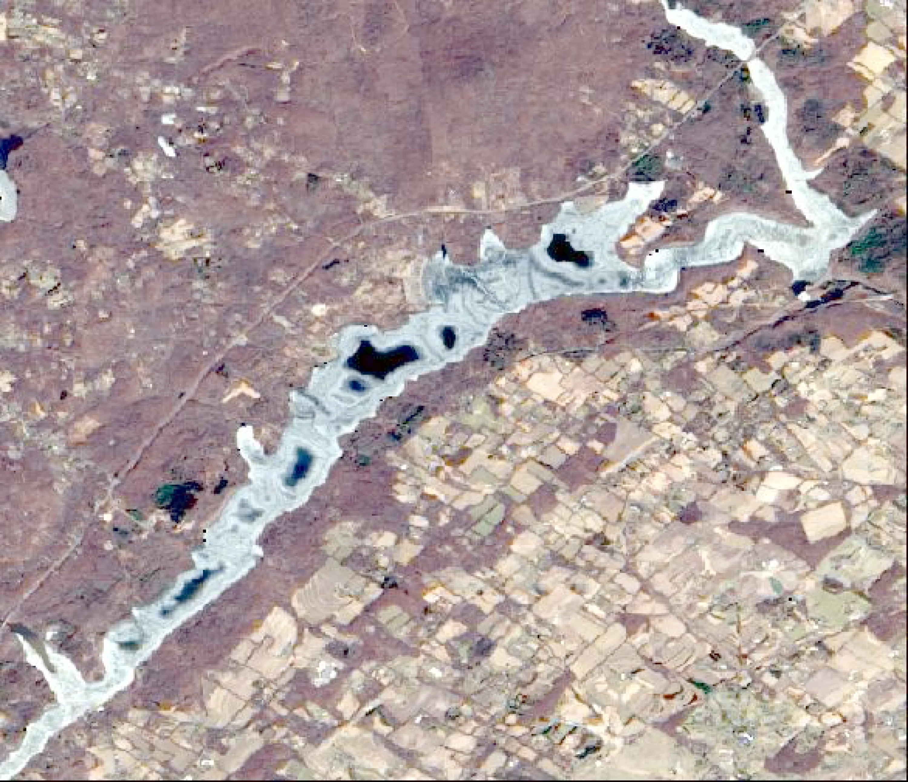
Analyze Water Clarity
Based on the provided imagery for Lake Nockamixon, here is the professional water clarity and tactical fishing analysis.
1. Overall Water Quality Summary
The imagery indicates a highly uniform water quality profile across the entire lake basin. The visual data shows a consistent Dark/Brown signature across the water body. According to the provided matrix, this corresponds to the Top-Left/Top-Center quadrant, indicating High Sediment (TSS) with Low to Moderate Chlorophyll (MCI). The lake is currently experiencing significant turbidity, likely due to recent runoff or wind-driven sediment suspension, resulting in visibility likely in the 1–4 foot range.
2. Detailed Clarity Zone Mapping & Characterization
- Zone 1: Main Basin & Central Channel (Brown/Tan)
- Matrix Position: Top-Left/Center (High Sediment, Low/Moderate Chlorophyll).
- Visibility: 1–4 feet.
- Tactical Implications: This is a "Power Fishing" zone. The water is stained, requiring baits that displace water and create noise to help fish locate them.
- Zone 2: Shoreline & Coves (Dark Brown/Tan)
- Matrix Position: Top-Left (High Sediment, Low Chlorophyll).
- Visibility: 2–6 feet (slightly clearer than the main channel due to less depth/agitation).
- Tactical Implications: Focus on high-contrast colors. The lack of significant chlorophyll suggests the turbidity is primarily inorganic sediment.
3. Turbidity/Algae Sources & Transition Zones
- Source Identification: The uniform brown coloration across the entire lake suggests a system-wide event, such as a recent heavy rainstorm causing significant watershed runoff or a major wind event that has turned over the shallow flats.
- Transition Zones: Because the imagery shows a lack of distinct "clear water" pockets (no Blue/Teal zones), there are no sharp "mudlines" to target. Instead, anglers should look for depth-based transitions—where the water is slightly deeper, the sediment may have settled more, creating a subtle "vertical" clarity break.
4. Species-Specific Clarity Strategy
- Bass: With visibility restricted to 1–4 feet, bass will be holding tight to hard structure (rocks, wood, docks). They will be less likely to chase moving baits over long distances. Target the shallowest cover where the water is slightly warmer (51°F).
- Walleye/Catfish: These species will thrive in these conditions. The high sediment levels provide cover for them to hunt more aggressively. Focus on the main lake points and the mouths of the larger coves.
- Crappie: Target the edges of submerged timber. In this level of turbidity, they will be pinned to the structure. Use vertical presentations to keep the bait in the "strike zone" longer.
5. Tactical Fishing Adjustments
- Lure Selection:
- Colors: Move away from natural shad or clear-water patterns. Use Black/Blue, Chartreuse/White, or Orange/Brown combinations. These provide the best silhouette against the stained water.
- Vibration: Use baits with heavy vibration—1/2 oz Spinnerbaits with Colorado blades or Lipless Crankbaits with loud rattles are essential.
- Presentation:
- Retrieve: Slow down. Even though the water is stained, the 51°F temperature dictates a slower, more methodical approach.
- Casting: Because the water is stained, you can fish closer to the boat (10–20 yards) than in clear water, allowing for more precise, shorter casts to specific targets.
- Line Selection: Use 15–20lb Braided line or 15lb Monofilament. The visibility is low enough that line spooking is not a primary concern; prioritize strength and abrasion resistance.
6. Seasonal Context
The widespread, uniform brown coloration is highly indicative of early spring runoff or a post-storm event. Given the current water temperature of 51°F, the lake is in a transitional state. The lack of significant chlorophyll (no bright green/red patches) suggests that the spring algae bloom has not yet fully kicked in, reinforcing the theory that the current turbidity is driven by sediment rather than biological productivity. Focus on areas where water might be clearing first, such as the backs of protected coves that have had time to settle.
Findings:
- Based on the provided imagery for Lake Nockamixon, here is the professional water clarity and tactical fishing analysis.
1. Overall Water Quality Summary
The imagery indicates a highly uniform water quality profile across the entire lake basin. The visual data shows a consistent Dark/Brown signature across the water body. According to the provided matrix, this corresponds to the Top-Left/Top-Center quadrant, indicating High Sediment (TSS) with Low to Moderate Chlorophyll (MCI). The lake is currently experiencing significant turbidity, likely due to recent runoff or wind-driven sediment suspension, resulting in visibility likely in the 1–4 foot range.
2. Detailed Clarity Zone Mapping & Characterization
- Zone 1: Main Basin & Central Channel (Brown/Tan)
- Matrix Position: Top-Left/Center (High Sediment, Low/Moderate Chlorophyll).
- Visibility: 1–4 feet.
- Tactical Implications: This is a "Power Fishing" zone. The water is stained, requiring baits that displace water and create noise to help fish locate them.
- Zone 2: Shoreline & Coves (Dark Brown/Tan)
- Matrix Position: Top-Left (High Sediment, Low Chlorophyll).
- Visibility: 2–6 feet (slightly clearer than the main channel due to less depth/agitation).
- Tactical Implications: Focus on high-contrast colors. The lack of significant chlorophyll suggests the turbidity is primarily inorganic sediment.
3. Turbidity/Algae Sources & Transition Zones
- Source Identification: The uniform brown coloration across the entire lake suggests a system-wide event, such as a recent heavy rainstorm causing significant watershed runoff or a major wind event that has turned over the shallow flats.
- Transition Zones: Because the imagery shows a lack of distinct "clear water" pockets (no Blue/Teal zones), there are no sharp "mudlines" to target. Instead, anglers should look for depth-based transitions—where the water is slightly deeper, the sediment may have settled more, creating a subtle "vertical" clarity break.
4. Species-Specific Clarity Strategy
- Bass: With visibility restricted to 1–4 feet, bass will be holding tight to hard structure (rocks, wood, docks). They will be less likely to chase moving baits over long distances. Target the shallowest cover where the water is slightly warmer (51°F).
- Walleye/Catfish: These species will thrive in these conditions. The high sediment levels provide cover for them to hunt more aggressively. Focus on the main lake points and the mouths of the larger coves.
- Crappie: Target the edges of submerged timber. In this level of turbidity, they will be pinned to the structure. Use vertical presentations to keep the bait in the "strike zone" longer.
5. Tactical Fishing Adjustments
- Lure Selection:
- Colors: Move away from natural shad or clear-water patterns. Use Black/Blue, Chartreuse/White, or Orange/Brown combinations. These provide the best silhouette against the stained water.
- Vibration: Use baits with heavy vibration—1/2 oz Spinnerbaits with Colorado blades or Lipless Crankbaits with loud rattles are essential.
- Presentation:
- Retrieve: Slow down. Even though the water is stained, the 51°F temperature dictates a slower, more methodical approach.
- Casting: Because the water is stained, you can fish closer to the boat (10–20 yards) than in clear water, allowing for more precise, shorter casts to specific targets.
- Line Selection: Use 15–20lb Braided line or 15lb Monofilament. The visibility is low enough that line spooking is not a primary concern; prioritize strength and abrasion resistance.
6. Seasonal Context
The widespread, uniform brown coloration is highly indicative of early spring runoff or a post-storm event. Given the current water temperature of 51°F, the lake is in a transitional state. The lack of significant chlorophyll (no bright green/red patches) suggests that the spring algae bloom has not yet fully kicked in, reinforcing the theory that the current turbidity is driven by sediment rather than biological productivity. Focus on areas where water might be clearing first, such as the backs of protected coves that have had time to settle.
How this was synthesized
Professional fishing guide analysis integrating 5 tools: analyze_pressure_trends, analyze_weather_conditions, analyze_solunar_timing, analyze_thermal_patterns, analyze_water_clarity. User request: 'What does the lake conditions expected to be on April 18th.'. Synthesis generated comprehensive plan with professional recommendations.