Lake Sharpe Fishing Report
Synthesis generated comprehensive plan with professional recommendations.
Lake Sharpe Fishing Report
Generated Mar 2, 2026, 8:10 PM.
Key fishing read
- Day 1: High pressure (1018mb) - tougher bite, use finesse tactics
- Day 1: High winds (35mph) - seek protected areas, use heavier lures
- Day 1: Drizzle, High: 49°F, Low: 23°F
- Day 2: High pressure (1019mb) - tougher bite, use finesse tactics
- Day 2: Moderate wind (14mph) - ideal conditions, target windblown points
- Day 2: MostlyClear, High: 54°F, Low: 30°F
- Day 3: High pressure (1016mb) - tougher bite, use finesse tactics
- Day 3: High winds (26mph) - seek protected areas, use heavier lures
Tool analysis details
Analyze Weather Conditions
Weather analysis for Lake Sharpe completed
Findings:
- Day 1: High pressure (1018mb) - tougher bite, use finesse tactics
- Day 1: High winds (35mph) - seek protected areas, use heavier lures
- Day 1: Drizzle, High: 49°F, Low: 23°F
- Day 2: High pressure (1019mb) - tougher bite, use finesse tactics
- Day 2: Moderate wind (14mph) - ideal conditions, target windblown points
Analyze Pressure Trends
Barometric pressure analysis for Lake Sharpe: falling trend at 1018.00mb
Findings:
- Falling pressure trend detected (1018.00 → lower). Fish will be more active - excellent feeding windows ahead!
- Target shallow areas, use aggressive presentations. Fish are actively feeding.
Lure Matrix Wind Clarity
Lure guidance for wind=windy, clarity=unknown.
Findings:
- Max thump: giant spinnerbaits, slow roll, contact cover
Estimate Seasonal Phase
No historical temperature data for Lake Sharpe
Analyze Solunar Timing
Solunar timing analysis for Lake Sharpe completed
Findings:
- Day 2: full - increased fish activity expected, especially at night
- Plan trips around major solunar periods for peak activity, minor periods offer secondary opportunities
Analyze Species Behavior
Species behavior analysis for Lake Sharpe completed
Findings:
- Walleye: Cold water active (33.0°F), target deep edges with live bait or slow jigs
- Smallmouth bass: Sluggish in cold water (33.0°F), target deep structure with slow presentations
- Smallmouth bass: Spring pre-spawn/spawn mode - target shallow flats and protected coves
- White bass: Sluggish in cold water (33.0°F), target deep structure with slow presentations
- White bass: Spring pre-spawn/spawn mode - target shallow flats and protected coves
Analyze Water Clarity
1. Overall Water Quality Summary
The imagery reveals predominantly clear water conditions across the main body of Lake Sharpe, characterized by extensive dark blue/teal coloring indicative of low sediment + low chlorophyll (bottom-left quadrant of the clarity matrix). This suggests excellent visibility (15-25+ feet) in the central and southeastern basins. However, localized turbidity and chlorophyll influences appear in the northwestern sector, with tan/brown (high sediment, low chlorophyll; top-left quadrant) and yellow/green streaks (high/moderate chlorophyll, low sediment; bottom-right/center quadrants) along a narrow inlet-like feature, transitioning to stained conditions (3-15 feet visibility). Cross-image comparison shows consistency in the clear main basin but slightly increased tan sediment loading in the second image's northwest, implying minor recent stirring or inflow activity without widespread degradation.
2. Detailed Clarity Zone Mapping & Characterization
Zone 1: Main Basin (Central to Southeast, ~60-70% of imaged area)
- Color Identification/Matrix Position: Uniform dark blue/teal (bottom-left quadrant).
- Combined Conditions: Low sediment + low chlorophyll = clearest water, 15-25+ feet visibility.
- Tactical Implications: Premium sight-fishing potential; fish hold tight to structure in cold 33°F water, requiring ultra-subtle presentations.
- Location Mapping: Central lake body extending southeast, bounded by darker shorelines on east/south edges.
- Transition Zone Identification: Sharp edges where this meets Zone 2 yellow/green to the northwest.
Zone 2: Northwestern Inlet/Arm (Narrow linear feature, left/western edge, ~15-20% of area)
- Color Identification/Matrix Position: Prominent yellow/green streaks in first image (bottom-right/center: high/moderate chlorophyll + low sediment); shifts to tan/brown overlay in second image (top-left: high sediment + low chlorophyll).
- Combined Conditions: Transitional stained water with algae influence (first image: 3-15 feet visibility) evolving to muddy sediment dominance (second image: 2-6 feet visibility).
- Tactical Implications: Reaction bites possible on edges; cold water demands downsized baits and slow retrieves to match sluggish fish metabolism.
- Location Mapping: Elongated northwest arm/inflow channel, running southwest-northeast along western shoreline, widest at northern tip.
- Transition Zone Identification: Gradual color fade from yellow/green-tan into dark blue main basin, forming a "clarity wall" ~1/3 from northwest shore.
Zone 3: Northern Shoreline Pocket (Top-left corner, ~10% of area)
- Color Identification/Matrix Position: Tan/brown dominant in second image (top-left quadrant), with faint yellow traces (bottom-right).
- Combined Conditions: High sediment + low-to-moderate chlorophyll = muddy stained water, 2-6 feet visibility.
- Tactical Implications: Vibration-heavy tactics essential; focus on bottom contact in cold conditions where fish seek warmth/stability.
- Location Mapping: Shallow pocket adjacent to northwest arm's northern terminus, near apparent shoreline point.
- Transition Zone Identification: Distinct mudline where tan meets dark blue, extending east into main basin.
Zone 4: Southwestern Fringe (Bottom-left extension, minor ~5%)
- Color Identification/Matrix Position: Dark blue/teal with thin yellow streak terminus (bottom-left fading to bottom-right).
- Combined Conditions: Mostly low sediment/chlorophyll (15-25+ feet), with localized high chlorophyll edge (3-8 feet).
- Tactical Implications: Finesse primary, but bright accents on streak for algae-edge reaction.
- Location Mapping: Southern end of northwest arm, protruding into main basin near western cove-like feature.
- Transition Zone Identification: Pinpoint terminus where yellow streak dissolves into teal—prime narrow edge.
3. Turbidity/Algae Sources & Transition Zones Analysis
Source Identification (Visual): Tan/brown turbidity (high sediment) originates from the northwest inlet/arm, likely wind-stirred shallows or minor runoff along the northern shoreline pocket, as evidenced by concentrated top-left coloring in the second image spreading southeast. Yellow/green algae concentrations (high/moderate chlorophyll) trace the same inlet channel in both images, suggesting nutrient inputs from this western inflow point, with streaks indicating current-driven dispersion into the main basin. No widespread red/orange extremes visible, limiting worst-case (<2 feet) zones.
Clarity Breaks/Edges:
- Sharp "mudline" transition (tan-brown to dark blue/teal) along the eastern edge of the northwest arm, running roughly east-west across the northern third—high ambush potential as baitfish cluster here.
- Gradual yellow/green-to-teal shift at the southwestern streak terminus, forming a subtle productivity edge ideal for suspended fish.
- These edges represent clarity breaks where cleaner main-basin fish invade stained inflows, concentrating forage and creating reaction opportunities in cold water.
4. Species-Specific Clarity Strategy (Recommendations tied to zones)
- Walleye/Sauger (prefer moderate clarity edges): Target Zone 2 northwest arm transitions and Zone 3 northern pocket mudline (tan/yellow-to-blue breaks, 2-15 feet visibility)—patrol these for baitfish fleeing inflows; use long casts into stained water from clear basin vantage.
- Largemouth/Smallmouth Bass: Focus on Zone 1 main basin (dark blue/teal, 15-25+ feet) near structural points (e.g., southeastern shorelines) for sight-feeding, and Zone 4 southwestern fringe edges for ambush from clear into chlorophyll-stained water.
- Crappie: Suspend near cover in Zone 2 inlet streaks (yellow/green, 3-15 feet), especially the northwest-to-central transition where algae provides micro-cover.
- Catfish: Bottom-drag in Zone 3 northern tan pocket (2-6 feet), leveraging high sediment for scent-based feeding near inflow.
5. Tactical Fishing Adjustments (Lures/Presentations tied to zones)
Zone 1 (Clear Dark Blue/Teal, 15-25+ ft): Natural colors (green pumpkin, shad, watermelon seed) on finesse jigs, Ned rigs, small swimbaits (downsize 25% for 33°F: 1/16-1/8 oz); slow drags/pauses, fluorocarbon 8-12lb, long casts (40+ yards), spot-on boat positioning to avoid spook. Fish clarity breaks by parallel casts along teal-yellow edges for subtle reaction. Zone 2 (Yellow/Green-Tan Transition, 2-15 ft): Bright/high-contrast (chartreuse, white/blue) chatterbaits, small spinnerbaits, soft plastics with rattles; moderate-slow retrieves, 12-15lb fluoro/mono, 20-30 yard casts. Exploit mudline walls with fan-casting from clear side, speeding up over streak for vibration trigger. Zone 3 (Tan/Brown Muddy, 2-6 ft): Black/blue or orange/chartreuse lipless cranks, 1/4 oz spinnerbaits, big worms; bottom-bouncing with noise, braided leader OK (15lb), short 10-20 yard casts, aggressive boat approach. Drag along mudline edges for "turbidity wall" thumps. Zone 4 (Southwest Fringe, 3-25 ft): Mix natural (browns) with bright blues on suspending jerkbaits; dead-stick or slow yo-yo, lighter line. Cast to streak terminus for edge finesse. General Clarity Breaks: Power-finesse hybrids (e.g., rattling jigheads) with faster rips at sharp transitions; wind-driven edges enhance bait scatter.
6. Seasonal Context (Interpretation of visual patterns)
The dominant dark blue/teal clarity in the main basin appears resilient and typical of stable cold-water periods (e.g., winter/early spring at 33°F), maintaining premium conditions despite localized northwest staining. The confined tan/yellow inlet influences suggest minor recent disturbance like wind-stirred shallows or light inflow, not unusual for current low-activity flows, with no extreme blooms indicating balanced nutrient levels. Transition edges remain sharp, signaling consistent productivity hotspots without signs of prolonged turbidity events.
Findings:
-
1. Overall Water Quality Summary
The imagery reveals predominantly clear water conditions across the main body of Lake Sharpe, characterized by extensive dark blue/teal coloring indicative of low sediment + low chlorophyll (bottom-left quadrant of the clarity matrix). This suggests excellent visibility (15-25+ feet) in the central and southeastern basins. However, localized turbidity and chlorophyll influences appear in the northwestern sector, with tan/brown (high sediment, low chlorophyll; top-left quadrant) and yellow/green streaks (high/moderate chlorophyll, low sediment; bottom-right/center quadrants) along a narrow inlet-like feature, transitioning to stained conditions (3-15 feet visibility). Cross-image comparison shows consistency in the clear main basin but slightly increased tan sediment loading in the second image's northwest, implying minor recent stirring or inflow activity without widespread degradation.
2. Detailed Clarity Zone Mapping & Characterization
Zone 1: Main Basin (Central to Southeast, ~60-70% of imaged area)
- Color Identification/Matrix Position: Uniform dark blue/teal (bottom-left quadrant).
- Combined Conditions: Low sediment + low chlorophyll = clearest water, 15-25+ feet visibility.
- Tactical Implications: Premium sight-fishing potential; fish hold tight to structure in cold 33°F water, requiring ultra-subtle presentations.
- Location Mapping: Central lake body extending southeast, bounded by darker shorelines on east/south edges.
- Transition Zone Identification: Sharp edges where this meets Zone 2 yellow/green to the northwest.
Zone 2: Northwestern Inlet/Arm (Narrow linear feature, left/western edge, ~15-20% of area)
- Color Identification/Matrix Position: Prominent yellow/green streaks in first image (bottom-right/center: high/moderate chlorophyll + low sediment); shifts to tan/brown overlay in second image (top-left: high sediment + low chlorophyll).
- Combined Conditions: Transitional stained water with algae influence (first image: 3-15 feet visibility) evolving to muddy sediment dominance (second image: 2-6 feet visibility).
- Tactical Implications: Reaction bites possible on edges; cold water demands downsized baits and slow retrieves to match sluggish fish metabolism.
- Location Mapping: Elongated northwest arm/inflow channel, running southwest-northeast along western shoreline, widest at northern tip.
- Transition Zone Identification: Gradual color fade from yellow/green-tan into dark blue main basin, forming a "clarity wall" ~1/3 from northwest shore.
Zone 3: Northern Shoreline Pocket (Top-left corner, ~10% of area)
- Color Identification/Matrix Position: Tan/brown dominant in second image (top-left quadrant), with faint yellow traces (bottom-right).
- Combined Conditions: High sediment + low-to-moderate chlorophyll = muddy stained water, 2-6 feet visibility.
- Tactical Implications: Vibration-heavy tactics essential; focus on bottom contact in cold conditions where fish seek warmth/stability.
- Location Mapping: Shallow pocket adjacent to northwest arm's northern terminus, near apparent shoreline point.
- Transition Zone Identification: Distinct mudline where tan meets dark blue, extending east into main basin.
Zone 4: Southwestern Fringe (Bottom-left extension, minor ~5%)
- Color Identification/Matrix Position: Dark blue/teal with thin yellow streak terminus (bottom-left fading to bottom-right).
- Combined Conditions: Mostly low sediment/chlorophyll (15-25+ feet), with localized high chlorophyll edge (3-8 feet).
- Tactical Implications: Finesse primary, but bright accents on streak for algae-edge reaction.
- Location Mapping: Southern end of northwest arm, protruding into main basin near western cove-like feature.
- Transition Zone Identification: Pinpoint terminus where yellow streak dissolves into teal—prime narrow edge.
3. Turbidity/Algae Sources & Transition Zones Analysis
Source Identification (Visual): Tan/brown turbidity (high sediment) originates from the northwest inlet/arm, likely wind-stirred shallows or minor runoff along the northern shoreline pocket, as evidenced by concentrated top-left coloring in the second image spreading southeast. Yellow/green algae concentrations (high/moderate chlorophyll) trace the same inlet channel in both images, suggesting nutrient inputs from this western inflow point, with streaks indicating current-driven dispersion into the main basin. No widespread red/orange extremes visible, limiting worst-case (<2 feet) zones.
Clarity Breaks/Edges:
- Sharp "mudline" transition (tan-brown to dark blue/teal) along the eastern edge of the northwest arm, running roughly east-west across the northern third—high ambush potential as baitfish cluster here.
- Gradual yellow/green-to-teal shift at the southwestern streak terminus, forming a subtle productivity edge ideal for suspended fish.
- These edges represent clarity breaks where cleaner main-basin fish invade stained inflows, concentrating forage and creating reaction opportunities in cold water.
4. Species-Specific Clarity Strategy (Recommendations tied to zones)
- Walleye/Sauger (prefer moderate clarity edges): Target Zone 2 northwest arm transitions and Zone 3 northern pocket mudline (tan/yellow-to-blue breaks, 2-15 feet visibility)—patrol these for baitfish fleeing inflows; use long casts into stained water from clear basin vantage.
- Largemouth/Smallmouth Bass: Focus on Zone 1 main basin (dark blue/teal, 15-25+ feet) near structural points (e.g., southeastern shorelines) for sight-feeding, and Zone 4 southwestern fringe edges for ambush from clear into chlorophyll-stained water.
- Crappie: Suspend near cover in Zone 2 inlet streaks (yellow/green, 3-15 feet), especially the northwest-to-central transition where algae provides micro-cover.
- Catfish: Bottom-drag in Zone 3 northern tan pocket (2-6 feet), leveraging high sediment for scent-based feeding near inflow.
5. Tactical Fishing Adjustments (Lures/Presentations tied to zones)
Zone 1 (Clear Dark Blue/Teal, 15-25+ ft): Natural colors (green pumpkin, shad, watermelon seed) on finesse jigs, Ned rigs, small swimbaits (downsize 25% for 33°F: 1/16-1/8 oz); slow drags/pauses, fluorocarbon 8-12lb, long casts (40+ yards), spot-on boat positioning to avoid spook. Fish clarity breaks by parallel casts along teal-yellow edges for subtle reaction. Zone 2 (Yellow/Green-Tan Transition, 2-15 ft): Bright/high-contrast (chartreuse, white/blue) chatterbaits, small spinnerbaits, soft plastics with rattles; moderate-slow retrieves, 12-15lb fluoro/mono, 20-30 yard casts. Exploit mudline walls with fan-casting from clear side, speeding up over streak for vibration trigger. Zone 3 (Tan/Brown Muddy, 2-6 ft): Black/blue or orange/chartreuse lipless cranks, 1/4 oz spinnerbaits, big worms; bottom-bouncing with noise, braided leader OK (15lb), short 10-20 yard casts, aggressive boat approach. Drag along mudline edges for "turbidity wall" thumps. Zone 4 (Southwest Fringe, 3-25 ft): Mix natural (browns) with bright blues on suspending jerkbaits; dead-stick or slow yo-yo, lighter line. Cast to streak terminus for edge finesse. General Clarity Breaks: Power-finesse hybrids (e.g., rattling jigheads) with faster rips at sharp transitions; wind-driven edges enhance bait scatter.
6. Seasonal Context (Interpretation of visual patterns)
The dominant dark blue/teal clarity in the main basin appears resilient and typical of stable cold-water periods (e.g., winter/early spring at 33°F), maintaining premium conditions despite localized northwest staining. The confined tan/yellow inlet influences suggest minor recent disturbance like wind-stirred shallows or light inflow, not unusual for current low-activity flows, with no extreme blooms indicating balanced nutrient levels. Transition edges remain sharp, signaling consistent productivity hotspots without signs of prolonged turbidity events.
Analyze Thermal Patterns
Overall Thermal Landscape Summary
No color-based thermal image is visible; the provided content is a text-based ASCII representation of a lake shoreline with scattered temperature labels (primarily 30°F, 32°F, 34°F, and one 42°F label, all in °F). Assuming North is at the top of the image. The lake shape is an irregular, elongated body oriented roughly east-west, with multiple narrow, branching inlets and bays extending northward and southward from a central channel-like area. Major visual anchors: (1) a prominent narrow inlet or river-like arm entering from the top-center (north), labeled with 32°F and 34°F; (2) a wider bay-like expansion in the lower-left (SW quadrant); (3) clustered labels around a central constriction point near the 42°F label. Dominant "temperatures" from labels: 30-34°F (-1 to 1°C), indicating extremely cold surface water below the provided color scale's minimum (very dark navy blue equivalent or colder). Approximate min/max from labels: 30°F (-1°C) to 42°F (6°C). No color variations observable due to text-only format; image quality prevents color-key matching.
Detailed Thermal Feature Analysis
Temperature Breaks: No color transitions visible (text-only). Labels show minor jumps, e.g., from clustered 30-32°F areas to the isolated 42°F label near the central constriction (mid-image, where multiple lines converge around the 42° mark, south of the top-center inlet). These are not abrupt but suggest potential warmer pockets relative to surroundings.
Pockets/Patches: Isolated warmer patch at the single 42°F (6°C) label, located at the central narrowing point (approximately mid-height, right of the main vertical channel, where shorelines pinch inward). Surrounding labels (30-34°F, -1 to 1°C) form uniform cold patches across most inlets, e.g., the northern arm (top third, left side) with 32-34°F labels.
Gradients: No gradients discernible in text format; labels are discrete points rather than continuous color shifts. General pattern: consistently cold labels (30-34°F) across 90%+ of the visible shoreline geometry, with no smooth transitions shown.
Uniform Areas: Vast majority of the lake body and inlets show uniform cold labels (30-34°F / -1 to 1°C), covering the entire eastern arm (right side, bottom half), the SW bay, and northern extensions. No warmer uniform zones beyond the single 42°F point.
Insightful Fish Behavior Interpretation
Surface temperatures indicated by labels (30-42°F / -1 to 6°C) are far below the color scale, suggesting deep winter or ice-edge conditions. Fish behavior: extremely sluggish metabolism, minimal surface feeding, and tight holding to any subtle warmth or structure. The 42°F spot may attract fish seeking slight comfort for slow recovery/feeding, but overall, expect very low activity—long soaks with slow presentations near labels. Surface-only relevance: fish unlikely to be active in open cold zones (30-34°F); any movement confined to shallows near warmer label. Transitions (e.g., 34°F to 42°F) could hold fish staging for comfort, but activity minimal.
Satellite Correlation Analysis
No additional satellite imagery provided beyond the text representation. Cannot correlate with inflows, springs, or structures. Shoreline geometry suggests potential inflows at the top-center narrow arm (32-34°F labels), possibly cooler input, but no visual confirmation. The 42°F label aligns with a constriction point, potentially wind-sheltered or sun-exposed shallow, causing slight surface warming—focus fishing there for surface-related patterns.
Actionable Fishing Recommendations
- Prioritize the isolated 42°F (6°C) label at the central constriction (mid-image height, where shorelines narrow right of the main channel, south of the north inlet arm)—slow-troll or anchor nearby for any surface-active fish using this relative warmth.
- Avoid uniform 30-34°F (-1 to 1°C) zones (most inlets/bays); fish surface minimally here.
- Tactics: Use ultra-slow retrieves or dead-stick in shallows near the 42°F spot; target dawn/dusk for any surface rise. Vertical jigging over the constriction if accessible. General: Poor surface conditions overall—image limits precision, but warmer label is the only actionable feature. Re-scan with color image for better intel.
Findings:
- Current surface temperature: 33.0°F. Fish metabolism significantly reduced in cold water. Target sunny, protected shorelines and use extremely slow presentations. Focus on midday when surface temperatures are warmest.
-
Overall Thermal Landscape Summary
No color-based thermal image is visible; the provided content is a text-based ASCII representation of a lake shoreline with scattered temperature labels (primarily 30°F, 32°F, 34°F, and one 42°F label, all in °F). Assuming North is at the top of the image. The lake shape is an irregular, elongated body oriented roughly east-west, with multiple narrow, branching inlets and bays extending northward and southward from a central channel-like area. Major visual anchors: (1) a prominent narrow inlet or river-like arm entering from the top-center (north), labeled with 32°F and 34°F; (2) a wider bay-like expansion in the lower-left (SW quadrant); (3) clustered labels around a central constriction point near the 42°F label. Dominant "temperatures" from labels: 30-34°F (-1 to 1°C), indicating extremely cold surface water below the provided color scale's minimum (very dark navy blue equivalent or colder). Approximate min/max from labels: 30°F (-1°C) to 42°F (6°C). No color variations observable due to text-only format; image quality prevents color-key matching.
Detailed Thermal Feature Analysis
Temperature Breaks: No color transitions visible (text-only). Labels show minor jumps, e.g., from clustered 30-32°F areas to the isolated 42°F label near the central constriction (mid-image, where multiple lines converge around the 42° mark, south of the top-center inlet). These are not abrupt but suggest potential warmer pockets relative to surroundings.
Pockets/Patches: Isolated warmer patch at the single 42°F (6°C) label, located at the central narrowing point (approximately mid-height, right of the main vertical channel, where shorelines pinch inward). Surrounding labels (30-34°F, -1 to 1°C) form uniform cold patches across most inlets, e.g., the northern arm (top third, left side) with 32-34°F labels.
Gradients: No gradients discernible in text format; labels are discrete points rather than continuous color shifts. General pattern: consistently cold labels (30-34°F) across 90%+ of the visible shoreline geometry, with no smooth transitions shown.
Uniform Areas: Vast majority of the lake body and inlets show uniform cold labels (30-34°F / -1 to 1°C), covering the entire eastern arm (right side, bottom half), the SW bay, and northern extensions. No warmer uniform zones beyond the single 42°F point.
Insightful Fish Behavior Interpretation
Surface temperatures indicated by labels (30-42°F / -1 to 6°C) are far below the color scale, suggesting deep winter or ice-edge conditions. Fish behavior: extremely sluggish metabolism, minimal surface feeding, and tight holding to any subtle warmth or structure. The 42°F spot may attract fish seeking slight comfort for slow recovery/feeding, but overall, expect very low activity—long soaks with slow presentations near labels. Surface-only relevance: fish unlikely to be active in open cold zones (30-34°F); any movement confined to shallows near warmer label. Transitions (e.g., 34°F to 42°F) could hold fish staging for comfort, but activity minimal.
Satellite Correlation Analysis
No additional satellite imagery provided beyond the text representation. Cannot correlate with inflows, springs, or structures. Shoreline geometry suggests potential inflows at the top-center narrow arm (32-34°F labels), possibly cooler input, but no visual confirmation. The 42°F label aligns with a constriction point, potentially wind-sheltered or sun-exposed shallow, causing slight surface warming—focus fishing there for surface-related patterns.
Actionable Fishing Recommendations
- Prioritize the isolated 42°F (6°C) label at the central constriction (mid-image height, where shorelines narrow right of the main channel, south of the north inlet arm)—slow-troll or anchor nearby for any surface-active fish using this relative warmth.
- Avoid uniform 30-34°F (-1 to 1°C) zones (most inlets/bays); fish surface minimally here.
- Tactics: Use ultra-slow retrieves or dead-stick in shallows near the 42°F spot; target dawn/dusk for any surface rise. Vertical jigging over the constriction if accessible. General: Poor surface conditions overall—image limits precision, but warmer label is the only actionable feature. Re-scan with color image for better intel.
- Spring warming: Focus on shallow bays and areas showing the warmest surface temperatures in thermal imagery as fish move into spawning areas.
Analyze Satellite Imagery
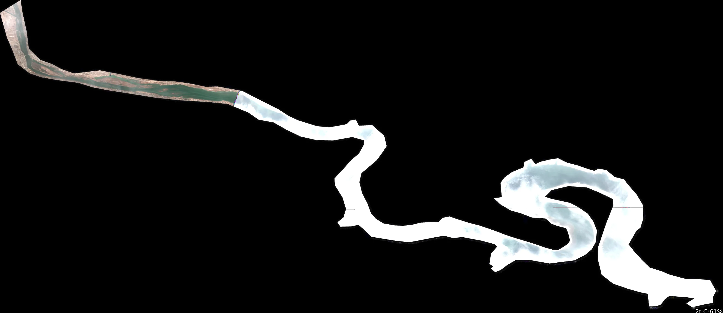
SATELLITE ANALYSIS: Lake Sharpe, SD (Buffalo County) - March 02, 2026
1. LAKE OVERVIEW (Natural Sections & Landmarks)
Lake Sharpe appears as an elongated, winding reservoir running roughly north-south, resembling a river channel that widens into broader basins.
- Northern section/arm: Narrow, serpentine inlet curving from the northwest, tightening into a channel-like arm before widening.
- Main lake body: Central widening area with a prominent westward loop/bend, forming the core open water flanked by irregular shorelines.
- Southern section/arm: Expands into a broader basin splitting into two distinct eastern and western arms/fingers at the southern end.
- Major creek arms: Narrow extensions visible in the northern inlet and subtle side notches along the main body east shore.
- Upper lake vs lower lake: Upper (northern) is narrow/channel-like; lower (southern) is wider basin-like.
- Major landmarks visible: None distinctly marked (no boat ramps, marinas, bridges, islands, or dams clearly outlined). Lake naturally divides via narrow necks: one at the north-to-main transition and another mid-main before the southern expansion.
- Note: Shoreline geometry shows sharp points (protrusions into water) and coves (indentations), with serpentine lines suggesting channel-like paths.
2. FINDABLE FISHING SPOTS
Identified 6 high-priority spots based on visible shoreline structure (points, bends, coves). Prioritized winter/pre-spawn patterns (33°F): channel bends, points near deep-water transitions (inferred from abrupt shoreline changes), and protected coves. No color gradients or cover (docks/vegetation) visible—focus on geological structure only. Spots ranked 1-10 using guidelines (structure complexity, depth transition via sharp lines, seasonal fit for walleye/bass in channels/points).
-
Northern section - the northwest inlet bend
- How to Find It: Enter from the northernmost narrow inlet; follow the first sharp right-hand curve where the shoreline hooks east.
- What You See: Tight serpentine channel bend with a protruding point on the west shore.
- Why Fish It (Priority: 8/10): Channel bend acts as structure for walleye staging in winter; adjacent point offers transition from shallow inlet to wider water (structure complexity high).
- Best Approach: Drift or troll the bend's inside edge; fan-cast the point from shallow to deep side.
-
Northern section - the eastern shore point before main lake
- How to Find It: From northern inlet, head south past the first bend to the prominent point jutting west from the east shore at the narrow-to-wide transition.
- What You See: Bold shoreline protrusion extending into the channel, flanked by smoother banks.
- Why Fish It (Priority: 9/10): Deep-water point at seasonal migration funnel (pre-spawn walleye/smallmouth); sharp geometry suggests drop-off (excellent depth transition + structure).
- Best Approach: Anchor or hold on the point's deep side; jig vertically or bounce bottom along the edge.
-
Main lake body - the big westward loop point
- How to Find It: In the central main body, locate the major westward bulge/loop; target the southernmost protruding point on its west shore.
- What You See: Large shoreline hook with a distinct point pushing into open water amid the loop.
- Why Fish It (Priority: 10/10): Complex structure (bend + point) ideal for winter refuge; wind-blown exposure for walleye, protected inside for bass (top seasonal/structure score).
- Best Approach: Circle the point with electronics; slow-troll the loop's channel edge.
-
Main lake body - the east shore cove notch
- How to Find It: Central main body east shore, between the north transition and westward loop—find the deep indentation/cove cut into the line.
- What You See: Prominent shoreline recession forming a protected notch opposite the main loop.
- Why Fish It (Priority: 7/10): Cove provides wind protection with adjacent channel access; pre-spawn staging for catfish/drum near structure transition.
- Best Approach: Position boat at cove mouth; cast into notch or along entrance ledges.
-
Southern section - the western arm split point
- How to Find It: Head to southern basin; at the fork, take the left/western arm—fish the splitting point where the shoreline divides.
- What You See: Central point at the Y-split between western and main southern arms.
- Why Fish It (Priority: 8/10): Key junction point with dual-channel access; suits walleye on deep edges, bass on adjacent flats (high transition suitability).
- Best Approach: Straddle the point; work both sides with search baits.
-
Southern section - the eastern arm inlet
- How to Find It: Southern basin right/eastern arm; follow the narrow extension protruding southeast.
- What You See: Elongated narrow arm with curving inlet line suggesting creek-like entry.
- Why Fish It (Priority: 7/10): Channel arm leading to basin; winter walleye/white bass pattern on bends (good seasonal channel fit).
- Best Approach: Idle up the arm's length; target inside bends with vertical presentations.
3. VISIBLE FEATURES BY LAKE SECTION
Northern section: Narrow winding inlet with 2-3 sharp bends; east shore point at widening transition; subtle creek-like notch on west.
Main lake body: Westward loop with protruding point; east shore cove indentation; irregular points along both shores; narrow neck north entry.
Southern section: Broad basin forking into western (left) and eastern (right) arms; central split point; elongated eastern arm extension.
Eastern/Western arms (southern): Western arm shorter/wider; eastern arm narrow/curving; no other arms distinct.
4. PRACTICAL FISHING GUIDANCE
Suggested fishing progression (33°F winter focus: start deep channels, move to points as sun warms):
- Start (dawn/early): Northern section - northwest inlet bend (protected channel staging).
- Mid-morning: Main lake body - big westward loop point (sun-exposed structure).
- Pattern: Northern shallows/channels early → main lake points midday → southern arms afternoon (follow migration south). Walleye on points/edges; bass/catfish in coves/bends.
Navigation between sections:
- Northern to main: Follow widening channel past east shore point (no obstacles).
- Main to southern: Run south past westward loop, through open basin to fork.
- Arm access: Western arm direct left at split; eastern arm veers right/southeast—stay mid-channel in narrows.
All spots verifiable by shoreline shape alone—use GPS/chartplotter to match outline, then visually confirm points/coves from boat. Target species (walleye priority) hold near visible transitions.
Findings:
-
SATELLITE ANALYSIS: Lake Sharpe, SD (Buffalo County) - March 02, 2026
1. LAKE OVERVIEW (Natural Sections & Landmarks)
Lake Sharpe appears as an elongated, winding reservoir running roughly north-south, resembling a river channel that widens into broader basins.
- Northern section/arm: Narrow, serpentine inlet curving from the northwest, tightening into a channel-like arm before widening.
- Main lake body: Central widening area with a prominent westward loop/bend, forming the core open water flanked by irregular shorelines.
- Southern section/arm: Expands into a broader basin splitting into two distinct eastern and western arms/fingers at the southern end.
- Major creek arms: Narrow extensions visible in the northern inlet and subtle side notches along the main body east shore.
- Upper lake vs lower lake: Upper (northern) is narrow/channel-like; lower (southern) is wider basin-like.
- Major landmarks visible: None distinctly marked (no boat ramps, marinas, bridges, islands, or dams clearly outlined). Lake naturally divides via narrow necks: one at the north-to-main transition and another mid-main before the southern expansion.
- Note: Shoreline geometry shows sharp points (protrusions into water) and coves (indentations), with serpentine lines suggesting channel-like paths.
2. FINDABLE FISHING SPOTS
Identified 6 high-priority spots based on visible shoreline structure (points, bends, coves). Prioritized winter/pre-spawn patterns (33°F): channel bends, points near deep-water transitions (inferred from abrupt shoreline changes), and protected coves. No color gradients or cover (docks/vegetation) visible—focus on geological structure only. Spots ranked 1-10 using guidelines (structure complexity, depth transition via sharp lines, seasonal fit for walleye/bass in channels/points).
-
Northern section - the northwest inlet bend
- How to Find It: Enter from the northernmost narrow inlet; follow the first sharp right-hand curve where the shoreline hooks east.
- What You See: Tight serpentine channel bend with a protruding point on the west shore.
- Why Fish It (Priority: 8/10): Channel bend acts as structure for walleye staging in winter; adjacent point offers transition from shallow inlet to wider water (structure complexity high).
- Best Approach: Drift or troll the bend's inside edge; fan-cast the point from shallow to deep side.
-
Northern section - the eastern shore point before main lake
- How to Find It: From northern inlet, head south past the first bend to the prominent point jutting west from the east shore at the narrow-to-wide transition.
- What You See: Bold shoreline protrusion extending into the channel, flanked by smoother banks.
- Why Fish It (Priority: 9/10): Deep-water point at seasonal migration funnel (pre-spawn walleye/smallmouth); sharp geometry suggests drop-off (excellent depth transition + structure).
- Best Approach: Anchor or hold on the point's deep side; jig vertically or bounce bottom along the edge.
-
Main lake body - the big westward loop point
- How to Find It: In the central main body, locate the major westward bulge/loop; target the southernmost protruding point on its west shore.
- What You See: Large shoreline hook with a distinct point pushing into open water amid the loop.
- Why Fish It (Priority: 10/10): Complex structure (bend + point) ideal for winter refuge; wind-blown exposure for walleye, protected inside for bass (top seasonal/structure score).
- Best Approach: Circle the point with electronics; slow-troll the loop's channel edge.
-
Main lake body - the east shore cove notch
- How to Find It: Central main body east shore, between the north transition and westward loop—find the deep indentation/cove cut into the line.
- What You See: Prominent shoreline recession forming a protected notch opposite the main loop.
- Why Fish It (Priority: 7/10): Cove provides wind protection with adjacent channel access; pre-spawn staging for catfish/drum near structure transition.
- Best Approach: Position boat at cove mouth; cast into notch or along entrance ledges.
-
Southern section - the western arm split point
- How to Find It: Head to southern basin; at the fork, take the left/western arm—fish the splitting point where the shoreline divides.
- What You See: Central point at the Y-split between western and main southern arms.
- Why Fish It (Priority: 8/10): Key junction point with dual-channel access; suits walleye on deep edges, bass on adjacent flats (high transition suitability).
- Best Approach: Straddle the point; work both sides with search baits.
-
Southern section - the eastern arm inlet
- How to Find It: Southern basin right/eastern arm; follow the narrow extension protruding southeast.
- What You See: Elongated narrow arm with curving inlet line suggesting creek-like entry.
- Why Fish It (Priority: 7/10): Channel arm leading to basin; winter walleye/white bass pattern on bends (good seasonal channel fit).
- Best Approach: Idle up the arm's length; target inside bends with vertical presentations.
3. VISIBLE FEATURES BY LAKE SECTION
Northern section: Narrow winding inlet with 2-3 sharp bends; east shore point at widening transition; subtle creek-like notch on west.
Main lake body: Westward loop with protruding point; east shore cove indentation; irregular points along both shores; narrow neck north entry.
Southern section: Broad basin forking into western (left) and eastern (right) arms; central split point; elongated eastern arm extension.
Eastern/Western arms (southern): Western arm shorter/wider; eastern arm narrow/curving; no other arms distinct.
4. PRACTICAL FISHING GUIDANCE
Suggested fishing progression (33°F winter focus: start deep channels, move to points as sun warms):
- Start (dawn/early): Northern section - northwest inlet bend (protected channel staging).
- Mid-morning: Main lake body - big westward loop point (sun-exposed structure).
- Pattern: Northern shallows/channels early → main lake points midday → southern arms afternoon (follow migration south). Walleye on points/edges; bass/catfish in coves/bends.
Navigation between sections:
- Northern to main: Follow widening channel past east shore point (no obstacles).
- Main to southern: Run south past westward loop, through open basin to fork.
- Arm access: Western arm direct left at split; eastern arm veers right/southeast—stay mid-channel in narrows.
All spots verifiable by shoreline shape alone—use GPS/chartplotter to match outline, then visually confirm points/coves from boat. Target species (walleye priority) hold near visible transitions.
How this was synthesized
Professional fishing guide analysis integrating 11 tools: analyze_weather_conditions, analyze_pressure_trends, lure_matrix_wind_clarity, estimate_seasonal_phase, get_community_reports, analyze_solunar_timing, analyze_hourly_conditions, analyze_species_behavior, analyze_water_clarity, analyze_thermal_patterns, analyze_satellite_imagery. User request: 'Generate a comprehensive fishing report for Lake Sharpe. Use tools to analyze satellite structure, thermal patterns, water clarity, weather, and solunar timing, then synthesize a concise plan.'. Synthesis generated comprehensive plan with professional recommendations.