Normandy Lake Fishing Report
Synthesis generated comprehensive plan with professional recommendations.
Normandy Lake Fishing Report
Generated Apr 12, 2026, 3:08 AM.
Key fishing read
- Day 1: High pressure (1025mb) - tougher bite, use finesse tactics
- Day 1: Moderate wind (7mph) - ideal conditions, target windblown points
- Day 1: MostlyClear, High: 80°F, Low: 48°F
- Day 2: High pressure (1023mb) - tougher bite, use finesse tactics
- Day 2: High winds (27mph) - seek protected areas, use heavier lures
- Day 2: PartlyCloudy, High: 82°F, Low: 56°F
- Day 3: High pressure (1022mb) - tougher bite, use finesse tactics
- Day 3: High winds (36mph) - seek protected areas, use heavier lures
Tool analysis details
Analyze Weather Conditions
Weather analysis for Normandy Lake completed
Findings:
- Day 1: High pressure (1025mb) - tougher bite, use finesse tactics
- Day 1: Moderate wind (7mph) - ideal conditions, target windblown points
- Day 1: MostlyClear, High: 80°F, Low: 48°F
- Day 2: High pressure (1023mb) - tougher bite, use finesse tactics
- Day 2: High winds (27mph) - seek protected areas, use heavier lures
Analyze Pressure Trends
Barometric pressure analysis for Normandy Lake: falling trend at 1025.00mb
Findings:
- Falling pressure trend detected (1025.00 → lower). Fish will be more active - excellent feeding windows ahead!
- Target shallow areas, use aggressive presentations. Fish are actively feeding.
Analyze Thermal Patterns
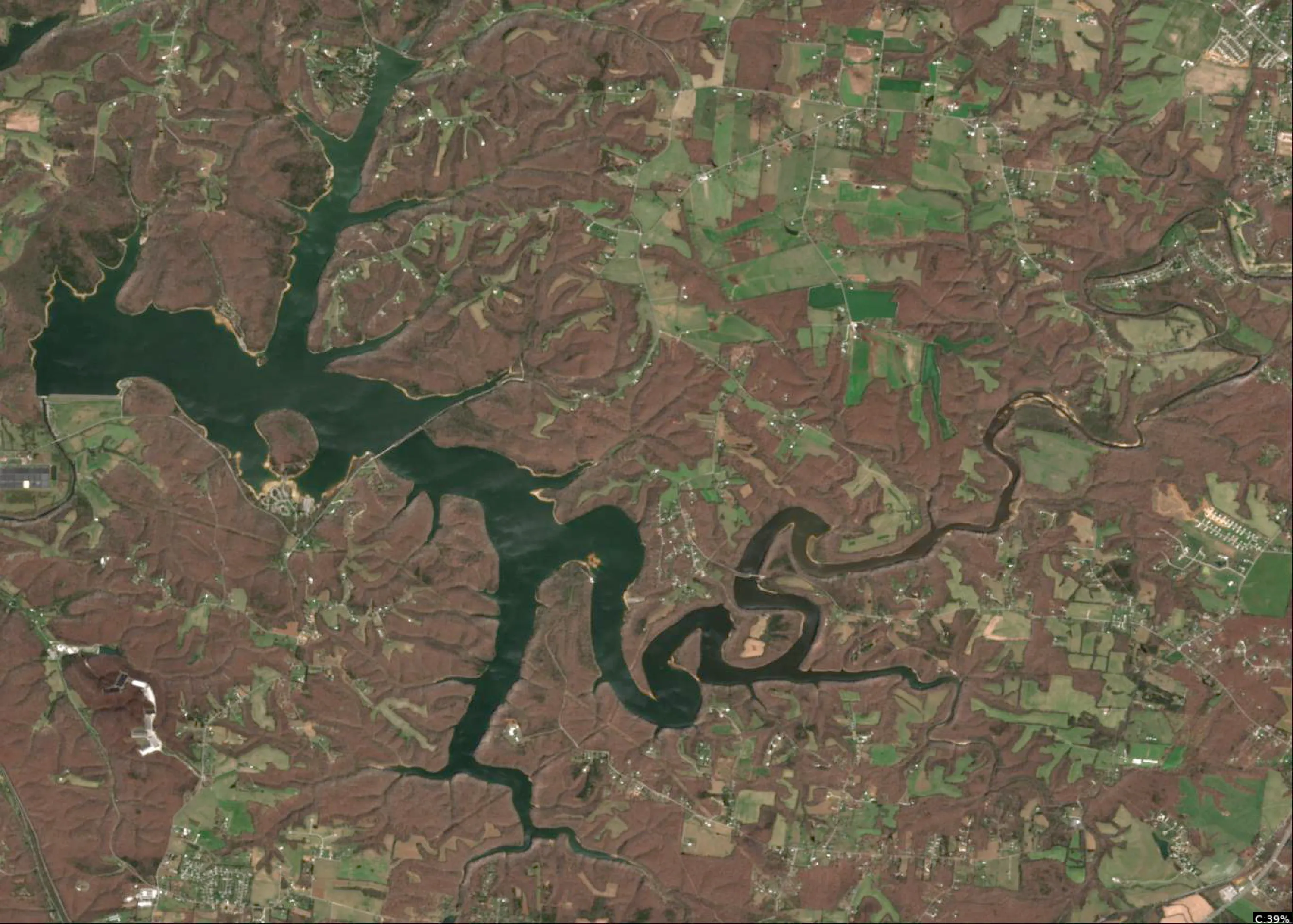
1. Overall Thermal Landscape Summary
- Assumed Orientation: Assuming North is at the top of the image.
- Major Visual Anchors:
- The Western Arm: A long, horizontal channel extending from the far left.
- The Central Junction: The area where the Western Arm meets the southern-trending channel.
- The Southern Inlet: The narrow, winding section at the bottom-center of the image.
- Summary: The lake exhibits a cool-to-moderate thermal profile. The majority of the water surface is dominated by Medium Blue (46-52°F / 8-11°C) and Light Blue (52-56°F / 11-13°C). There are localized pockets of Cyan/Light Teal (56-60°F / 13-16°C), particularly in the western and central sections.
- Temperature Range: Visible surface temperatures range from approximately 42°F (6°C) in the deepest blue pockets to 60°F (16°C) in the warmest cyan-tinted areas.
2. Detailed Thermal Feature Analysis
- Temperature Breaks:
- Location: The most significant break occurs at the Central Junction. Here, the transition from the cooler Medium Blue (46-52°F) of the southern channel to the warmer Light Blue/Cyan (52-60°F) of the Western Arm creates a distinct thermal edge.
- Significance: These edges are high-percentage areas for fish to stage, as they provide a choice between metabolic comfort and active feeding zones.
- Pockets/Patches:
- Location: A distinct Cyan/Light Teal (56-60°F) patch is visible in the northernmost section of the Western Arm.
- Significance: This represents the warmest surface water in the image, likely indicating a shallow flat or a protected area receiving maximum solar radiation.
- Gradients:
- Location: A gradual warming gradient is visible moving from the southern tip of the Southern Inlet northward toward the Central Junction.
- Significance: Fish often move along these gradients to find their preferred "comfort zone" temperature.
- Uniform Areas:
- Location: The mid-section of the Southern Inlet shows a consistent Medium Blue (46-52°F).
- Significance: This indicates a stable, cooler environment where fish are likely less active and holding tighter to structure.
3. Insightful Fish Behavior Interpretation
- Activity Levels: The fish in the Medium Blue (46-52°F) areas are in a "transition" state—they are beginning to move but remain sluggish. Focus on slow-moving presentations here.
- Feeding Zones: The Cyan/Light Teal (56-60°F) areas are the most active zones. Fish here are likely in a pre-spawn or active feeding mode, making these the primary targets for aggressive lures.
- Movement: Expect fish to be migrating from the cooler, uniform southern waters toward the warmer, more thermally diverse Western Arm and Central Junction.
4. Satellite Correlation Analysis
- Inflow/Outflow: The cooler Dark Blue (42-46°F) pockets at the extreme ends of the Southern Inlet and the far-left tip of the Western Arm suggest potential inflow points or areas of deeper, cooler water influence.
- Structure-Surface Relationships: The thermal "fingers" extending into the shoreline in the Western Arm suggest shallow bays or coves that are warming faster than the main channel. These are prime locations for surface-oriented activity.
5. Actionable Fishing Recommendations
- Target the "Warm" Pockets: Prioritize the Cyan/Light Teal (56-60°F) areas in the Western Arm. These are your best bets for active, feeding fish. Use lures that can be worked at a moderate pace.
- Work the Thermal Edges: Focus your efforts at the Central Junction where the Light Blue (52-56°F) meets the Medium Blue (46-52°F). Position your boat in the cooler water and cast into the warmer water, retrieving your lure through the temperature break.
- Slow Down in the South: In the Medium Blue (46-52°F) areas of the Southern Inlet, use finesse tactics. The fish here are likely holding tight to the bottom or structure and will not chase fast-moving baits.
- Monitor the Gradient: If the bite is slow, move along the gradient in the Southern Inlet until you find the transition point where the water begins to warm toward the 55°F mark.
Findings:
- Current surface temperature: 58.0°F. Fish showing moderate activity levels. Target temperature transition zones where warmer water meets cooler areas, often near inflows or wind-protected bays.
-
1. Overall Thermal Landscape Summary
- Assumed Orientation: Assuming North is at the top of the image.
- Major Visual Anchors:
- The Western Arm: A long, horizontal channel extending from the far left.
- The Central Junction: The area where the Western Arm meets the southern-trending channel.
- The Southern Inlet: The narrow, winding section at the bottom-center of the image.
- Summary: The lake exhibits a cool-to-moderate thermal profile. The majority of the water surface is dominated by Medium Blue (46-52°F / 8-11°C) and Light Blue (52-56°F / 11-13°C). There are localized pockets of Cyan/Light Teal (56-60°F / 13-16°C), particularly in the western and central sections.
- Temperature Range: Visible surface temperatures range from approximately 42°F (6°C) in the deepest blue pockets to 60°F (16°C) in the warmest cyan-tinted areas.
2. Detailed Thermal Feature Analysis
- Temperature Breaks:
- Location: The most significant break occurs at the Central Junction. Here, the transition from the cooler Medium Blue (46-52°F) of the southern channel to the warmer Light Blue/Cyan (52-60°F) of the Western Arm creates a distinct thermal edge.
- Significance: These edges are high-percentage areas for fish to stage, as they provide a choice between metabolic comfort and active feeding zones.
- Pockets/Patches:
- Location: A distinct Cyan/Light Teal (56-60°F) patch is visible in the northernmost section of the Western Arm.
- Significance: This represents the warmest surface water in the image, likely indicating a shallow flat or a protected area receiving maximum solar radiation.
- Gradients:
- Location: A gradual warming gradient is visible moving from the southern tip of the Southern Inlet northward toward the Central Junction.
- Significance: Fish often move along these gradients to find their preferred "comfort zone" temperature.
- Uniform Areas:
- Location: The mid-section of the Southern Inlet shows a consistent Medium Blue (46-52°F).
- Significance: This indicates a stable, cooler environment where fish are likely less active and holding tighter to structure.
3. Insightful Fish Behavior Interpretation
- Activity Levels: The fish in the Medium Blue (46-52°F) areas are in a "transition" state—they are beginning to move but remain sluggish. Focus on slow-moving presentations here.
- Feeding Zones: The Cyan/Light Teal (56-60°F) areas are the most active zones. Fish here are likely in a pre-spawn or active feeding mode, making these the primary targets for aggressive lures.
- Movement: Expect fish to be migrating from the cooler, uniform southern waters toward the warmer, more thermally diverse Western Arm and Central Junction.
4. Satellite Correlation Analysis
- Inflow/Outflow: The cooler Dark Blue (42-46°F) pockets at the extreme ends of the Southern Inlet and the far-left tip of the Western Arm suggest potential inflow points or areas of deeper, cooler water influence.
- Structure-Surface Relationships: The thermal "fingers" extending into the shoreline in the Western Arm suggest shallow bays or coves that are warming faster than the main channel. These are prime locations for surface-oriented activity.
5. Actionable Fishing Recommendations
- Target the "Warm" Pockets: Prioritize the Cyan/Light Teal (56-60°F) areas in the Western Arm. These are your best bets for active, feeding fish. Use lures that can be worked at a moderate pace.
- Work the Thermal Edges: Focus your efforts at the Central Junction where the Light Blue (52-56°F) meets the Medium Blue (46-52°F). Position your boat in the cooler water and cast into the warmer water, retrieving your lure through the temperature break.
- Slow Down in the South: In the Medium Blue (46-52°F) areas of the Southern Inlet, use finesse tactics. The fish here are likely holding tight to the bottom or structure and will not chase fast-moving baits.
- Monitor the Gradient: If the bite is slow, move along the gradient in the Southern Inlet until you find the transition point where the water begins to warm toward the 55°F mark.
- Spring warming: Focus on shallow bays and areas showing the warmest surface temperatures in thermal imagery as fish move into spawning areas.
Analyze Water Clarity
This analysis of Normandy Lake is based on the provided multi-spectral imagery, focusing on the interplay between chlorophyll concentration (MCI) and suspended solids (TSS).
1. Overall Water Quality Summary
Normandy Lake currently exhibits a highly stable, clear-water profile across the majority of its main basin. The imagery shows a dominant "Deep Blue/Teal" signature, indicating low sediment and low chlorophyll levels. The primary biological activity is restricted to the extreme shallow shorelines and the furthest reaches of the riverine inflows, where a thin "Green" fringe indicates localized, minor primary productivity.
2. Detailed Clarity Zone Mapping & Characterization
- Zone A: The Main Basin (Deep Blue/Teal)
- Matrix Position: Bottom-Left (Low Sediment + Low Chlorophyll).
- Conditions: High visibility (15-25+ feet).
- Tactical Implications: This is your "finesse zone." Fish will be highly visual and easily spooked. Use fluorocarbon lines (8-10lb), natural color soft plastics (green pumpkin, watermelon), and long-distance casting techniques.
- Zone B: Shoreline Fringes (Bright Green)
- Matrix Position: Bottom-Center (Moderate Chlorophyll + Low Sediment).
- Conditions: 8-15 feet visibility.
- Tactical Implications: These are the primary feeding zones. The slight algae tint provides enough cover for predators to ambush prey. Excellent for moving baits like small swimbaits or jerkbaits.
- Zone C: Riverine/Creek Inflows (Yellow-Green/Tan)
- Matrix Position: Top-Center (Moderate Chlorophyll + High Sediment).
- Conditions: 1-4 feet visibility.
- Tactical Implications: The most "productive" water in the system. The combination of sediment and algae creates a "stained" environment. Switch to power fishing tactics here.
3. Turbidity/Algae Sources & Transition Zones
- Sources: The "Green" signatures are strictly confined to the immediate shoreline and the narrow, winding creek arms. This suggests that the lake is currently experiencing very little runoff-driven turbidity (no large "Tan" plumes). The algae is likely localized to shallow, sun-warmed pockets.
- Transition Zones: The most critical fishing areas are the "Hard Edges" where the deep blue main basin meets the bright green shoreline fringe. These represent the transition from open-water cruising lanes to ambush-heavy structure.
4. Species-Specific Clarity Strategy
- Largemouth/Smallmouth Bass: Target the Transition Zones (Blue to Green). Bass will likely be positioned on the edge of the clear water, looking into the slightly stained shoreline fringe to pick off baitfish.
- Crappie: Focus on the Creek Inflows (Yellow-Green). Crappie prefer the slightly stained water for protection. Use small jigs with chartreuse tails to provide visibility in the 1-4ft visibility range.
- Sight-Feeders (Walleye/Stripers): Stick to the Main Basin (Blue/Teal). These species will be patrolling the deep, clear water. Use natural-colored, shad-imitating lures that mimic the forage base found in the clear, open water.
5. Tactical Fishing Adjustments
- Clear Zone (Blue/Teal):
- Lures: Ned rigs, drop shots, weightless senkos.
- Colors: Natural shad, watermelon seed.
- Retrieve: Slow, subtle, finesse-oriented.
- Stained Zone (Green/Yellow-Green):
- Lures: 1/4 oz spinnerbaits, square-bill crankbaits, chatterbaits.
- Colors: Chartreuse/White, Bluegill patterns.
- Retrieve: Moderate to fast; use vibration to help fish locate the lure.
6. Seasonal Context
The imagery suggests a stable, post-spawn or early summer pattern. The lack of widespread "Tan" (sediment) indicates no recent heavy rainfall or major runoff events. The confinement of chlorophyll to the immediate shorelines suggests that the water temperature is likely warming, but the main body of the lake remains deep and clear, providing a thermal refuge for fish. The lake is currently in a "clear-water dominant" phase, requiring anglers to prioritize stealth and natural presentations over noise and vibration.
Findings:
- This analysis of Normandy Lake is based on the provided multi-spectral imagery, focusing on the interplay between chlorophyll concentration (MCI) and suspended solids (TSS).
1. Overall Water Quality Summary
Normandy Lake currently exhibits a highly stable, clear-water profile across the majority of its main basin. The imagery shows a dominant "Deep Blue/Teal" signature, indicating low sediment and low chlorophyll levels. The primary biological activity is restricted to the extreme shallow shorelines and the furthest reaches of the riverine inflows, where a thin "Green" fringe indicates localized, minor primary productivity.
2. Detailed Clarity Zone Mapping & Characterization
- Zone A: The Main Basin (Deep Blue/Teal)
- Matrix Position: Bottom-Left (Low Sediment + Low Chlorophyll).
- Conditions: High visibility (15-25+ feet).
- Tactical Implications: This is your "finesse zone." Fish will be highly visual and easily spooked. Use fluorocarbon lines (8-10lb), natural color soft plastics (green pumpkin, watermelon), and long-distance casting techniques.
- Zone B: Shoreline Fringes (Bright Green)
- Matrix Position: Bottom-Center (Moderate Chlorophyll + Low Sediment).
- Conditions: 8-15 feet visibility.
- Tactical Implications: These are the primary feeding zones. The slight algae tint provides enough cover for predators to ambush prey. Excellent for moving baits like small swimbaits or jerkbaits.
- Zone C: Riverine/Creek Inflows (Yellow-Green/Tan)
- Matrix Position: Top-Center (Moderate Chlorophyll + High Sediment).
- Conditions: 1-4 feet visibility.
- Tactical Implications: The most "productive" water in the system. The combination of sediment and algae creates a "stained" environment. Switch to power fishing tactics here.
3. Turbidity/Algae Sources & Transition Zones
- Sources: The "Green" signatures are strictly confined to the immediate shoreline and the narrow, winding creek arms. This suggests that the lake is currently experiencing very little runoff-driven turbidity (no large "Tan" plumes). The algae is likely localized to shallow, sun-warmed pockets.
- Transition Zones: The most critical fishing areas are the "Hard Edges" where the deep blue main basin meets the bright green shoreline fringe. These represent the transition from open-water cruising lanes to ambush-heavy structure.
4. Species-Specific Clarity Strategy
- Largemouth/Smallmouth Bass: Target the Transition Zones (Blue to Green). Bass will likely be positioned on the edge of the clear water, looking into the slightly stained shoreline fringe to pick off baitfish.
- Crappie: Focus on the Creek Inflows (Yellow-Green). Crappie prefer the slightly stained water for protection. Use small jigs with chartreuse tails to provide visibility in the 1-4ft visibility range.
- Sight-Feeders (Walleye/Stripers): Stick to the Main Basin (Blue/Teal). These species will be patrolling the deep, clear water. Use natural-colored, shad-imitating lures that mimic the forage base found in the clear, open water.
5. Tactical Fishing Adjustments
- Clear Zone (Blue/Teal):
- Lures: Ned rigs, drop shots, weightless senkos.
- Colors: Natural shad, watermelon seed.
- Retrieve: Slow, subtle, finesse-oriented.
- Stained Zone (Green/Yellow-Green):
- Lures: 1/4 oz spinnerbaits, square-bill crankbaits, chatterbaits.
- Colors: Chartreuse/White, Bluegill patterns.
- Retrieve: Moderate to fast; use vibration to help fish locate the lure.
6. Seasonal Context
The imagery suggests a stable, post-spawn or early summer pattern. The lack of widespread "Tan" (sediment) indicates no recent heavy rainfall or major runoff events. The confinement of chlorophyll to the immediate shorelines suggests that the water temperature is likely warming, but the main body of the lake remains deep and clear, providing a thermal refuge for fish. The lake is currently in a "clear-water dominant" phase, requiring anglers to prioritize stealth and natural presentations over noise and vibration.
Analyze Species Behavior
Species behavior analysis for Normandy Lake completed
Findings:
- Largemouth bass: Spring pre-spawn/spawn mode - target shallow flats and protected coves
- Smallmouth bass: Spring pre-spawn/spawn mode - target shallow flats and protected coves
- Spotted bass: Spring pre-spawn/spawn mode - target shallow flats and protected coves
- White crappie: Pre-spawn/spawn temps (58.0°F), target shallow cover with small jigs
- Black crappie: Pre-spawn/spawn temps (58.0°F), target shallow cover with small jigs
How this was synthesized
Professional fishing guide analysis integrating 5 tools: analyze_weather_conditions, analyze_pressure_trends, analyze_thermal_patterns, analyze_water_clarity, analyze_species_behavior. User request: 'Analyze species-specific behavior patterns for current conditions including feeding triggers, depth preferences, and movement corridors based on temperature and weather.'. Synthesis generated comprehensive plan with professional recommendations.