Norris Lake Fishing Report
Synthesis generated comprehensive plan with professional recommendations.
Norris Lake Fishing Report
Generated Mar 15, 2026, 12:53 AM.
Key fishing read
- Rising pressure trend (1019.00 → higher). Bite may slow down as fish become less active.
- Switch to finesse tactics, target deeper structure. Fish will be less aggressive.
- Day 1: High pressure (1019mb) - tougher bite, use finesse tactics
- Day 1: Moderate wind (9mph) - ideal conditions, target windblown points
- Day 1: MostlyClear, High: 69°F, Low: 39°F
- Day 2: High pressure (1010mb) - tougher bite, use finesse tactics
- Day 2: High winds (28mph) - seek protected areas, use heavier lures
- Day 2: Cloudy, High: 71°F, Low: 48°F
Tool analysis details
Analyze Pressure Trends
Barometric pressure analysis for Norris Lake: rising trend at 1019.00mb
Findings:
- Rising pressure trend (1019.00 → higher). Bite may slow down as fish become less active.
- Switch to finesse tactics, target deeper structure. Fish will be less aggressive.
Analyze Weather Conditions
Weather analysis for Norris Lake completed
Findings:
- Day 1: High pressure (1019mb) - tougher bite, use finesse tactics
- Day 1: Moderate wind (9mph) - ideal conditions, target windblown points
- Day 1: MostlyClear, High: 69°F, Low: 39°F
- Day 2: High pressure (1010mb) - tougher bite, use finesse tactics
- Day 2: High winds (28mph) - seek protected areas, use heavier lures
Estimate Seasonal Phase
No historical temperature data for Norris Lake
Analyze Solunar Timing
Solunar timing analysis for Norris Lake completed
Findings:
- Plan trips around major solunar periods for peak activity, minor periods offer secondary opportunities
Lure Matrix Wind Clarity
Lure guidance for wind=moderate, clarity=unknown.
Findings:
- Loud/bright: chartreuse/black, Colorado blades, big profile cranks
Analyze Species Behavior
Species behavior analysis for Norris Lake completed
Findings:
- Largemouth bass: Spring pre-spawn/spawn mode - target shallow flats and protected coves
- Smallmouth bass: Spring pre-spawn/spawn mode - target shallow flats and protected coves
- Spotted bass: Spring pre-spawn/spawn mode - target shallow flats and protected coves
- White bass: Spring pre-spawn/spawn mode - target shallow flats and protected coves
- Striped bass: Spring pre-spawn/spawn mode - target shallow flats and protected coves
Analyze Satellite Imagery
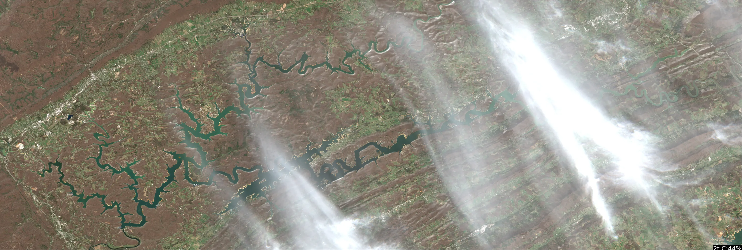
This analysis focuses on the Powell River arm of Norris Lake (Claiborne County), which is the visible section in your provided imagery. Given the current water temperature of 54°F, fish are in a pre-spawn transition, moving from the main river channel toward the shallower secondary creeks and coves.
1. LAKE OVERVIEW
- Section: This is the upper riverine section of the lake. It is characterized by a distinct, serpentine river channel that winds through the valley.
- Navigation: The "main channel" is the darker, deeper water that snakes through the center of the frame. The lighter-colored water along the banks represents the shallower flats and transition zones.
- Landmarks: The primary navigation feature is the main river channel. You are looking for the "bends" in this channel where the deep water swings close to the shoreline.
2. FINDABLE FISHING SPOTS
Targeting the "Channel Swings" where the river channel hits the bank.
-
The Sharp Outside Bend (Upper-Mid Section):
- How to Find: Follow the main river channel upstream until you see a sharp "S" curve where the dark water pushes directly against the bank.
- What You See: A distinct, high-contrast transition from dark (deep) to light (shallow) right at the bank.
- Why Fish It: This is a classic migration highway. Bass will use this deep-to-shallow transition to move into the adjacent flats.
- Approach: Cast parallel to the bank, working a jerkbait or crankbait from the shallow edge out into the dark water.
-
The Creek Mouth Intersection (Mid-Section):
- How to Find: Look for where a smaller, lighter-colored tributary channel meets the main dark river channel.
- What You See: A "Y" intersection where the water color changes.
- Why Fish It: These intersections are staging areas. Fish will hold here before moving into the smaller creek arms to spawn.
- Approach: Focus on the "point" created by the intersection. Use a jig or soft plastic to probe the bottom.
-
The Inside Bend Flat (Lower-Mid Section):
- How to Find: Locate a wide, light-colored area on the inside of a river bend.
- What You See: A large, shallow flat with a gradual color gradient.
- Why Fish It: As the water warms to 54°F, these flats absorb heat faster than the deep channel.
- Approach: Use a slow-moving bait like a shaky head or a vibrating jig to cover the flat.
-
The "Necked-Down" Channel (Upper Section):
- How to Find: Find the narrowest point in the river channel where the banks are closest together.
- What You See: A constriction in the dark water path.
- Why Fish It: This creates a natural funnel. Any fish moving up or down the river must pass through this area.
- Approach: Position the boat in the center and cast toward the banks on both sides.
3. VISIBLE FEATURES BY SECTION
- Upper Riverine Section: Characterized by tight, frequent bends. Focus on the "outside" of these bends where the channel is deepest.
- Mid-Section: The channel widens slightly. Look for the points where the river channel makes a hard turn—these are the most prominent structural features.
- Creek Mouths: Visible as lighter-colored "fingers" extending from the main dark channel. These are your primary targets for pre-spawn movement.
4. PRACTICAL FISHING GUIDANCE
- Start (Early Morning): Begin at the Creek Mouth Intersections. The fish will be staging here, waiting for the sun to hit the shallows.
- Mid-Morning: Move to the Inside Bend Flats. As the sun warms the water, fish will push onto these flats to feed.
- Pattern: Think of the river channel as a "highway." The fish are currently moving from the deep "highway" (the dark channel) to the "off-ramps" (the creek mouths and shallow flats).
- Navigation: Stay within the dark water channel when moving between spots to avoid shallow-water hazards. Use your depth finder to confirm the transition from the dark channel to the light flats as you approach your target.
Disclaimer: This analysis is based on satellite imagery interpretation. Always prioritize on-board sonar and local navigation charts for safe boating, as water levels in Norris Lake fluctuate significantly.
Findings:
- This analysis focuses on the Powell River arm of Norris Lake (Claiborne County), which is the visible section in your provided imagery. Given the current water temperature of 54°F, fish are in a pre-spawn transition, moving from the main river channel toward the shallower secondary creeks and coves.
1. LAKE OVERVIEW
- Section: This is the upper riverine section of the lake. It is characterized by a distinct, serpentine river channel that winds through the valley.
- Navigation: The "main channel" is the darker, deeper water that snakes through the center of the frame. The lighter-colored water along the banks represents the shallower flats and transition zones.
- Landmarks: The primary navigation feature is the main river channel. You are looking for the "bends" in this channel where the deep water swings close to the shoreline.
2. FINDABLE FISHING SPOTS
Targeting the "Channel Swings" where the river channel hits the bank.
-
The Sharp Outside Bend (Upper-Mid Section):
- How to Find: Follow the main river channel upstream until you see a sharp "S" curve where the dark water pushes directly against the bank.
- What You See: A distinct, high-contrast transition from dark (deep) to light (shallow) right at the bank.
- Why Fish It: This is a classic migration highway. Bass will use this deep-to-shallow transition to move into the adjacent flats.
- Approach: Cast parallel to the bank, working a jerkbait or crankbait from the shallow edge out into the dark water.
-
The Creek Mouth Intersection (Mid-Section):
- How to Find: Look for where a smaller, lighter-colored tributary channel meets the main dark river channel.
- What You See: A "Y" intersection where the water color changes.
- Why Fish It: These intersections are staging areas. Fish will hold here before moving into the smaller creek arms to spawn.
- Approach: Focus on the "point" created by the intersection. Use a jig or soft plastic to probe the bottom.
-
The Inside Bend Flat (Lower-Mid Section):
- How to Find: Locate a wide, light-colored area on the inside of a river bend.
- What You See: A large, shallow flat with a gradual color gradient.
- Why Fish It: As the water warms to 54°F, these flats absorb heat faster than the deep channel.
- Approach: Use a slow-moving bait like a shaky head or a vibrating jig to cover the flat.
-
The "Necked-Down" Channel (Upper Section):
- How to Find: Find the narrowest point in the river channel where the banks are closest together.
- What You See: A constriction in the dark water path.
- Why Fish It: This creates a natural funnel. Any fish moving up or down the river must pass through this area.
- Approach: Position the boat in the center and cast toward the banks on both sides.
3. VISIBLE FEATURES BY SECTION
- Upper Riverine Section: Characterized by tight, frequent bends. Focus on the "outside" of these bends where the channel is deepest.
- Mid-Section: The channel widens slightly. Look for the points where the river channel makes a hard turn—these are the most prominent structural features.
- Creek Mouths: Visible as lighter-colored "fingers" extending from the main dark channel. These are your primary targets for pre-spawn movement.
4. PRACTICAL FISHING GUIDANCE
- Start (Early Morning): Begin at the Creek Mouth Intersections. The fish will be staging here, waiting for the sun to hit the shallows.
- Mid-Morning: Move to the Inside Bend Flats. As the sun warms the water, fish will push onto these flats to feed.
- Pattern: Think of the river channel as a "highway." The fish are currently moving from the deep "highway" (the dark channel) to the "off-ramps" (the creek mouths and shallow flats).
- Navigation: Stay within the dark water channel when moving between spots to avoid shallow-water hazards. Use your depth finder to confirm the transition from the dark channel to the light flats as you approach your target.
Disclaimer: This analysis is based on satellite imagery interpretation. Always prioritize on-board sonar and local navigation charts for safe boating, as water levels in Norris Lake fluctuate significantly.
Analyze Thermal Patterns
1. Overall Thermal Landscape Summary
- Assumed Orientation: North is at the top of the image.
- Major Visual Anchors: The lake is characterized by two primary, elongated sections. The Western Section is a complex, dendritic (branching) system with multiple narrow coves. The Eastern Section is a long, linear, and relatively narrow body of water.
- Dominant Temperatures: The lake is dominated by Medium Blue (46-52°F / 8-11°C) and Dark Blue (42-46°F / 6-8°C).
- Temperature Range: Based on the provided labels and color key, the surface temperatures range from approximately 47°F (8°C) in the main channels to 55°F (13°C) in the isolated, protected coves of the Western Section.
2. Detailed Thermal Feature Analysis
Temperature Breaks
- Location: The most significant thermal break occurs in the Western Section, specifically at the mouths of the smaller, branching coves.
- Significance: The transition from the main channel (Dark Blue/47-48°F) to the interior of the coves (Light Blue/51-55°F) represents a critical "warming zone." These boundaries are high-percentage areas where fish will stage to move between the colder main body and the slightly warmer, more stable water of the coves.
Pockets/Patches
- Location: The Western Section contains several distinct "warm" pockets (Light Blue, 51-55°F). These are located in the terminal ends of the narrow, branching coves.
- Significance: These pockets are isolated from the main channel flow. Because they are smaller and more protected, they retain heat better than the main lake, making them the most active areas in the system.
Gradients
- Location: A gradual thermal gradient is visible moving from the main channel of the Eastern Section toward the shoreline.
- Significance: The water near the center of the Eastern Section is consistently cooler (Dark Blue, 47-48°F), while the water immediately adjacent to the shoreline shows a slight warming trend (Medium Blue, 50°F).
Uniform Areas
- Location: The entire Eastern Section exhibits a high degree of thermal uniformity, consistently hovering around the 48-50°F range.
- Significance: This indicates a well-mixed environment with little thermal diversity, suggesting fish will be more dispersed and less likely to be concentrated by temperature alone.
3. Insightful Fish Behavior Interpretation
- General Behavior: The lake is in an early spring transition. Fish are currently in a "slow" state, heavily influenced by the cold water temperatures.
- Movement Patterns: Fish are likely holding in deeper, more stable water in the main channels (Dark Blue areas) but will make short, opportunistic forays into the slightly warmer coves (Light Blue areas) during the warmest parts of the day.
- Feeding: Expect very slow, deliberate feeding. The most aggressive fish will be found in the 55°F (13°C) pockets in the Western Section, as these are the only areas approaching pre-spawn staging temperatures.
4. Satellite Correlation Analysis
- Inflow/Outflow: The narrow, dendritic nature of the Western Section suggests these are creek arms. The cooler temperatures (47°F) in the main channels likely indicate the primary riverine influence, while the warmer pockets (55°F) are likely stagnant, sun-warmed backwaters.
- Structure-Surface Relationships: The "points" where these coves meet the main channel are the most critical features. These points act as funnels for fish moving between the cold main lake and the warmer, protected coves.
5. Actionable Fishing Recommendations
- Target the "Warm" Coves: Focus your efforts in the Western Section of the lake. Specifically, target the terminal ends of the narrow coves where the water reaches the 55°F range.
- Fish the Transitions: Work the points at the mouths of the coves in the Western Section. Use a slow, methodical presentation (e.g., suspending jerkbaits or slow-rolled jigs) to entice fish that are staging at the break between the 47°F main channel and the 51-55°F cove water.
- Avoid the Eastern Section: Given the thermal uniformity (48-50°F) and lack of significant warm pockets, the Eastern Section will likely be a "grind." If you must fish here, focus on the immediate shoreline where the water is slightly warmer than the main channel.
- Timing: Because the water is generally cold (42-55°F), prioritize fishing during the afternoon when the sun has had the maximum amount of time to warm the surface of the protected coves.
Findings:
- Current surface temperature: 54.0°F. Fish showing moderate activity levels. Target temperature transition zones where warmer water meets cooler areas, often near inflows or wind-protected bays.
-
1. Overall Thermal Landscape Summary
- Assumed Orientation: North is at the top of the image.
- Major Visual Anchors: The lake is characterized by two primary, elongated sections. The Western Section is a complex, dendritic (branching) system with multiple narrow coves. The Eastern Section is a long, linear, and relatively narrow body of water.
- Dominant Temperatures: The lake is dominated by Medium Blue (46-52°F / 8-11°C) and Dark Blue (42-46°F / 6-8°C).
- Temperature Range: Based on the provided labels and color key, the surface temperatures range from approximately 47°F (8°C) in the main channels to 55°F (13°C) in the isolated, protected coves of the Western Section.
2. Detailed Thermal Feature Analysis
Temperature Breaks
- Location: The most significant thermal break occurs in the Western Section, specifically at the mouths of the smaller, branching coves.
- Significance: The transition from the main channel (Dark Blue/47-48°F) to the interior of the coves (Light Blue/51-55°F) represents a critical "warming zone." These boundaries are high-percentage areas where fish will stage to move between the colder main body and the slightly warmer, more stable water of the coves.
Pockets/Patches
- Location: The Western Section contains several distinct "warm" pockets (Light Blue, 51-55°F). These are located in the terminal ends of the narrow, branching coves.
- Significance: These pockets are isolated from the main channel flow. Because they are smaller and more protected, they retain heat better than the main lake, making them the most active areas in the system.
Gradients
- Location: A gradual thermal gradient is visible moving from the main channel of the Eastern Section toward the shoreline.
- Significance: The water near the center of the Eastern Section is consistently cooler (Dark Blue, 47-48°F), while the water immediately adjacent to the shoreline shows a slight warming trend (Medium Blue, 50°F).
Uniform Areas
- Location: The entire Eastern Section exhibits a high degree of thermal uniformity, consistently hovering around the 48-50°F range.
- Significance: This indicates a well-mixed environment with little thermal diversity, suggesting fish will be more dispersed and less likely to be concentrated by temperature alone.
3. Insightful Fish Behavior Interpretation
- General Behavior: The lake is in an early spring transition. Fish are currently in a "slow" state, heavily influenced by the cold water temperatures.
- Movement Patterns: Fish are likely holding in deeper, more stable water in the main channels (Dark Blue areas) but will make short, opportunistic forays into the slightly warmer coves (Light Blue areas) during the warmest parts of the day.
- Feeding: Expect very slow, deliberate feeding. The most aggressive fish will be found in the 55°F (13°C) pockets in the Western Section, as these are the only areas approaching pre-spawn staging temperatures.
4. Satellite Correlation Analysis
- Inflow/Outflow: The narrow, dendritic nature of the Western Section suggests these are creek arms. The cooler temperatures (47°F) in the main channels likely indicate the primary riverine influence, while the warmer pockets (55°F) are likely stagnant, sun-warmed backwaters.
- Structure-Surface Relationships: The "points" where these coves meet the main channel are the most critical features. These points act as funnels for fish moving between the cold main lake and the warmer, protected coves.
5. Actionable Fishing Recommendations
- Target the "Warm" Coves: Focus your efforts in the Western Section of the lake. Specifically, target the terminal ends of the narrow coves where the water reaches the 55°F range.
- Fish the Transitions: Work the points at the mouths of the coves in the Western Section. Use a slow, methodical presentation (e.g., suspending jerkbaits or slow-rolled jigs) to entice fish that are staging at the break between the 47°F main channel and the 51-55°F cove water.
- Avoid the Eastern Section: Given the thermal uniformity (48-50°F) and lack of significant warm pockets, the Eastern Section will likely be a "grind." If you must fish here, focus on the immediate shoreline where the water is slightly warmer than the main channel.
- Timing: Because the water is generally cold (42-55°F), prioritize fishing during the afternoon when the sun has had the maximum amount of time to warm the surface of the protected coves.
- Spring warming: Focus on shallow bays and areas showing the warmest surface temperatures in thermal imagery as fish move into spawning areas.
Analyze Water Clarity
This analysis of Norris Lake is based on the provided satellite imagery, which highlights distinct chlorophyll (MCI) and sediment (TSS) patterns.
1. Overall Water Quality Summary
Norris Lake currently exhibits a highly stratified water quality profile. The main basin and deep-water channels are dominated by Dark Blue/Teal (Low Sediment/Low Chlorophyll), indicating excellent clarity (15-25+ feet). Conversely, the extreme upper reaches of the creek arms and riverine inflows show Green to Yellow/Tan (Moderate to High Chlorophyll/Sediment), indicating productive, stained water. The lake is currently in a "clear-water dominant" state, with turbidity and biological activity restricted primarily to the shallow, terminal ends of the major tributaries.
2. Detailed Clarity Zone Mapping & Characterization
- Zone A: The Main Basin (Deep Blue/Teal)
- Matrix Position: Bottom-Left (Low Sediment/Low Chlorophyll).
- Conditions: 15-25+ feet visibility.
- Tactical Implications: This is your "finesse zone." Use fluorocarbon lines (8-10lb), natural-colored soft plastics (green pumpkin, watermelon), and suspending jerkbaits. Stealth is paramount; maintain long casting distances.
- Zone B: Mid-Creek Arms (Green/Yellow)
- Matrix Position: Bottom-Center/Right (Moderate Chlorophyll/Low Sediment).
- Conditions: 8-15 feet visibility.
- Tactical Implications: Productive transition water. This is the "sweet spot" for moving baits. Use a mix of natural and bright colors (chartreuse/white). Spinnerbaits and medium-diving crankbaits are highly effective here.
- Zone C: Terminal Inflows/Creek Heads (Tan/Brown)
- Matrix Position: Top-Left/Center (High Sediment/Moderate Chlorophyll).
- Conditions: 1-4 feet visibility.
- Tactical Implications: Power fishing zone. Use high-vibration baits (chatterbaits, lipless cranks) with loud rattles. Bright colors (chartreuse, white, orange) are necessary to help fish locate the lure in the stained water.
3. Turbidity/Algae Sources & Transition Zones
- Sources: The Tan/Brown signatures are concentrated at the extreme northern and western terminal ends of the creek arms. These are clearly driven by runoff and sediment inflow from the primary feeder streams.
- Transition Zones: The "Clarity Breaks" occur where the Tan/Brown water meets the Deep Blue main channel. These are high-percentage ambush points. Predators (Bass/Walleye) will often sit just inside the clear water, facing the stained water to pick off baitfish disoriented by the transition.
4. Species-Specific Clarity Strategy
- Bass: Target the Transition Zones (where Green meets Blue). Use a "search bait" (spinnerbait) to cover water along these edges. If the bite is slow, switch to a jig in the clearer water adjacent to the mudline.
- Walleye: Focus on the Zone B (Green/Yellow) areas. Walleye prefer the slight tint provided by the chlorophyll, which offers them a predatory advantage over prey in the 8-15ft visibility range.
- Crappie: Look for them in the Zone C (Tan/Green) areas, specifically near any visible structure (docks, laydowns). They will be tighter to cover in these stained conditions.
5. Tactical Fishing Adjustments
- Clear Water (Zone A): Use 8-10lb fluorocarbon. Focus on finesse presentations (Ned rigs, drop shots).
- Stained Water (Zone C): Use 15-20lb braid or monofilament. Increase lure profile size and noise.
- Clarity Breaks: The most effective technique is to cast from the clear water into the stained water, retrieving the lure through the "wall" of the transition. This mimics baitfish moving from safety into the nutrient-rich stained zone.
6. Seasonal Context
The imagery shows a stable, clear-water environment typical of a reservoir in a post-runoff or stable-weather phase. The lack of widespread "Red/Orange" (High Chlorophyll/High Sediment) suggests that there is no major, lake-wide algae bloom currently occurring. The turbidity is localized to the extreme inflows, which is a healthy sign for the main body of the lake, suggesting that the majority of the reservoir is currently in a high-visibility, sight-fishing-friendly state. Given the 54°F water temperature, focus on the Zone B (Green) areas, as these will hold slightly more heat and biological activity than the deep, cold, clear main basin.
Findings:
- This analysis of Norris Lake is based on the provided satellite imagery, which highlights distinct chlorophyll (MCI) and sediment (TSS) patterns.
1. Overall Water Quality Summary
Norris Lake currently exhibits a highly stratified water quality profile. The main basin and deep-water channels are dominated by Dark Blue/Teal (Low Sediment/Low Chlorophyll), indicating excellent clarity (15-25+ feet). Conversely, the extreme upper reaches of the creek arms and riverine inflows show Green to Yellow/Tan (Moderate to High Chlorophyll/Sediment), indicating productive, stained water. The lake is currently in a "clear-water dominant" state, with turbidity and biological activity restricted primarily to the shallow, terminal ends of the major tributaries.
2. Detailed Clarity Zone Mapping & Characterization
- Zone A: The Main Basin (Deep Blue/Teal)
- Matrix Position: Bottom-Left (Low Sediment/Low Chlorophyll).
- Conditions: 15-25+ feet visibility.
- Tactical Implications: This is your "finesse zone." Use fluorocarbon lines (8-10lb), natural-colored soft plastics (green pumpkin, watermelon), and suspending jerkbaits. Stealth is paramount; maintain long casting distances.
- Zone B: Mid-Creek Arms (Green/Yellow)
- Matrix Position: Bottom-Center/Right (Moderate Chlorophyll/Low Sediment).
- Conditions: 8-15 feet visibility.
- Tactical Implications: Productive transition water. This is the "sweet spot" for moving baits. Use a mix of natural and bright colors (chartreuse/white). Spinnerbaits and medium-diving crankbaits are highly effective here.
- Zone C: Terminal Inflows/Creek Heads (Tan/Brown)
- Matrix Position: Top-Left/Center (High Sediment/Moderate Chlorophyll).
- Conditions: 1-4 feet visibility.
- Tactical Implications: Power fishing zone. Use high-vibration baits (chatterbaits, lipless cranks) with loud rattles. Bright colors (chartreuse, white, orange) are necessary to help fish locate the lure in the stained water.
3. Turbidity/Algae Sources & Transition Zones
- Sources: The Tan/Brown signatures are concentrated at the extreme northern and western terminal ends of the creek arms. These are clearly driven by runoff and sediment inflow from the primary feeder streams.
- Transition Zones: The "Clarity Breaks" occur where the Tan/Brown water meets the Deep Blue main channel. These are high-percentage ambush points. Predators (Bass/Walleye) will often sit just inside the clear water, facing the stained water to pick off baitfish disoriented by the transition.
4. Species-Specific Clarity Strategy
- Bass: Target the Transition Zones (where Green meets Blue). Use a "search bait" (spinnerbait) to cover water along these edges. If the bite is slow, switch to a jig in the clearer water adjacent to the mudline.
- Walleye: Focus on the Zone B (Green/Yellow) areas. Walleye prefer the slight tint provided by the chlorophyll, which offers them a predatory advantage over prey in the 8-15ft visibility range.
- Crappie: Look for them in the Zone C (Tan/Green) areas, specifically near any visible structure (docks, laydowns). They will be tighter to cover in these stained conditions.
5. Tactical Fishing Adjustments
- Clear Water (Zone A): Use 8-10lb fluorocarbon. Focus on finesse presentations (Ned rigs, drop shots).
- Stained Water (Zone C): Use 15-20lb braid or monofilament. Increase lure profile size and noise.
- Clarity Breaks: The most effective technique is to cast from the clear water into the stained water, retrieving the lure through the "wall" of the transition. This mimics baitfish moving from safety into the nutrient-rich stained zone.
6. Seasonal Context
The imagery shows a stable, clear-water environment typical of a reservoir in a post-runoff or stable-weather phase. The lack of widespread "Red/Orange" (High Chlorophyll/High Sediment) suggests that there is no major, lake-wide algae bloom currently occurring. The turbidity is localized to the extreme inflows, which is a healthy sign for the main body of the lake, suggesting that the majority of the reservoir is currently in a high-visibility, sight-fishing-friendly state. Given the 54°F water temperature, focus on the Zone B (Green) areas, as these will hold slightly more heat and biological activity than the deep, cold, clear main basin.
How this was synthesized
Professional fishing guide analysis integrating 11 tools: analyze_hourly_conditions, analyze_pressure_trends, analyze_weather_conditions, estimate_seasonal_phase, analyze_solunar_timing, get_community_reports, lure_matrix_wind_clarity, analyze_species_behavior, analyze_satellite_imagery, analyze_thermal_patterns, analyze_water_clarity. User request: 'Generate a comprehensive fishing report for Norris Lake. Use tools to analyze satellite structure, thermal patterns, water clarity, weather, and solunar timing, then synthesize a concise plan.'. Synthesis generated comprehensive plan with professional recommendations.