Sterling Farmer Lake Fishing Report
Synthesis generated comprehensive plan with professional recommendations.
Sterling Farmer Lake Fishing Report
Generated Mar 1, 2026, 6:38 PM.
Key fishing read
- Day 1: High pressure (1021mb) - tougher bite, use finesse tactics
- Day 1: High winds (17mph) - seek protected areas, use heavier lures
- Day 1: PartlyCloudy, High: 69°F, Low: 46°F
- Day 2: High pressure (1023mb) - tougher bite, use finesse tactics
- Day 2: High winds (21mph) - seek protected areas, use heavier lures
- Day 2: Cloudy, High: 66°F, Low: 47°F
- Day 3: High pressure (1023mb) - tougher bite, use finesse tactics
- Day 3: High winds (46mph) - seek protected areas, use heavier lures
Tool analysis details
Analyze Weather Conditions
Weather analysis for Sterling Farmer Lake completed
Findings:
- Day 1: High pressure (1021mb) - tougher bite, use finesse tactics
- Day 1: High winds (17mph) - seek protected areas, use heavier lures
- Day 1: PartlyCloudy, High: 69°F, Low: 46°F
- Day 2: High pressure (1023mb) - tougher bite, use finesse tactics
- Day 2: High winds (21mph) - seek protected areas, use heavier lures
Analyze Pressure Trends
Barometric pressure analysis for Sterling Farmer Lake: falling trend at 1021.00mb
Findings:
- Falling pressure trend detected (1021.00 → lower). Fish will be more active - excellent feeding windows ahead!
- Target shallow areas, use aggressive presentations. Fish are actively feeding.
Analyze Solunar Timing
Solunar timing analysis for Sterling Farmer Lake completed
Findings:
- Day 3: full - increased fish activity expected, especially at night
- Plan trips around major solunar periods for peak activity, minor periods offer secondary opportunities
Analyze Thermal Patterns
Overall Thermal Landscape Summary
Assuming North is at the top of the image, East to the right, West to the left, and South at the bottom (standard orientation for satellite imagery). The lake appears as an irregularly shaped body of water, roughly oval with jagged shorelines, spanning the full image frame. Major visual anchors include: (1) a prominent light green patch in the upper-left (NW) quadrant, (2) a large central cyan-dominated expanse, and (3) a cluster of blue tones extending from the bottom-right (SE) corner inward. Dominant colors are cyan/light teal (56-60°F / 13-16°C) and light/medium blue (46-56°F / 8-13°C), with minor light green accents (60-64°F / 16-18°C). Approximate min/max visible temperatures: coolest medium/dark blue areas at 46-52°F (8-11°C), warmest light green at 60-64°F (16-18°C).
Detailed Thermal Feature Analysis
Temperature Breaks
Clearly visible abrupt color transitions include: (1) sharp boundaries where cyan/light teal (56-60°F / 13-16°C) shifts to light blue (52-56°F / 11-13°C) along the eastern edge of the central cyan expanse, running north-south parallel to the right shoreline; (2) a distinct break from light green (60-64°F / 16-18°C) in the NW patch to surrounding cyan (56-60°F / 13-16°C), forming a narrow eastern edge of the green patch; (3) a jagged transition from bottom-SE blue cluster (46-52°F / 8-11°C) into adjacent cyan areas, protruding westward like a finger-shaped intrusion. These breaks are moderately sharp, indicating potential surface temperature fronts.
Pockets/Patches
- Light green pocket (60-64°F / 16-18°C): Isolated rectangular patch in the upper-left (NW) quadrant, bordered by cyan to the south and east.
- Cyan/light teal patches (56-60°F / 13-16°C): Dominant central and mid-right areas, including a large blocky mass south of the NW green patch and extending into the NE quadrant.
- Blue pockets (46-56°F / 8-13°C): Smaller clustered patches in the bottom-right (SE) corner, with one distinct light blue spot (52-56°F / 11-13°C) labeled near 54-55°F annotations, and medium blue extensions northwest from there.
Gradients
Gradual transitions visible from cyan/light teal (56-60°F / 13-16°C) fading into light blue (52-56°F / 11-13°C) across the southern half of the central expanse, spanning roughly 4-8°F (2-4°C) over short distances; also a subtle west-to-east gradient within the NW green patch blending into cooler cyan.
Uniform Areas
- Large uniform cyan/light teal zone (56-60°F / 13-16°C): Covers the majority of the central and NE areas, appearing consistent without internal breaks.
- Uniform blue zone (46-52°F / 8-11°C): Solid patch in the bottom-SE corner, extending slightly leftward.
Insightful Fish Behavior Interpretation
Surface temperatures in the 46-64°F (8-18°C) range suggest early spring transition conditions, with fish likely sluggish in cooler blue zones (46-56°F / 8-13°C) but increasingly active in cyan/light green areas (56-64°F / 13-18°C), where feeding windows lengthen and movement toward warmer shallows occurs. Fish may congregate along visible temperature breaks (e.g., cyan-to-blue edges) for comfort and bait concentration, using these fronts for ambush feeding at the surface. Warmer light green patches (60-64°F / 16-18°C) in the NW could hold aggressive surface feeders, while uniform cyan expanses support transitional schooling behavior. Expect minimal activity in the SE blue cluster due to cold-induced lethargy; focus on surface-oriented tactics near breaks where subtle warming drives baitfish and predator positioning.
Satellite Correlation Analysis
No additional standard satellite imagery (e.g., visible light or topo maps) is provided alongside the thermal data. Thermal patterns align with general shoreline geometry: the NW light green patch may correspond to a shallow cove or wind-sheltered area retaining warmth, while SE blue tones suggest open-water mixing or inflow influence at the jagged southern shore. No clear inflow mouths, springs, or wind-mixed zones are visually confirmed without supporting imagery.
Actionable Fishing Recommendations
- Prime Targets: Fish the sharp cyan-to-blue breaks, especially the north-south edge along the eastern central expanse (east of the main cyan body) and the westward-protruding blue finger from the SE corner—drift or troll jigs/spoons here for fish staging on 4-8°F (2-4°C) fronts.
- High-Priority Warm Patch: Target the light green pocket (60-64°F / 16-18°C) in the NW quadrant with topwater or shallow crankbaits for active surface biters; its eastern break into cyan is a key transition.
- Secondary Zones: Work uniform central cyan (56-60°F / 13-16°C) with slow presentations; avoid deep casts as this is surface data only.
- Tactics: Early morning/evening for all zones; use electronics to confirm surface schools near described breaks. Image quality limits finer details, so prioritize these visible patterns over unconfirmed areas.
Findings:
- Current surface temperature: 46.0°F. Fish metabolism significantly reduced in cold water. Target sunny, protected shorelines and use extremely slow presentations. Focus on midday when surface temperatures are warmest.
-
Overall Thermal Landscape Summary
Assuming North is at the top of the image, East to the right, West to the left, and South at the bottom (standard orientation for satellite imagery). The lake appears as an irregularly shaped body of water, roughly oval with jagged shorelines, spanning the full image frame. Major visual anchors include: (1) a prominent light green patch in the upper-left (NW) quadrant, (2) a large central cyan-dominated expanse, and (3) a cluster of blue tones extending from the bottom-right (SE) corner inward. Dominant colors are cyan/light teal (56-60°F / 13-16°C) and light/medium blue (46-56°F / 8-13°C), with minor light green accents (60-64°F / 16-18°C). Approximate min/max visible temperatures: coolest medium/dark blue areas at 46-52°F (8-11°C), warmest light green at 60-64°F (16-18°C).
Detailed Thermal Feature Analysis
Temperature Breaks
Clearly visible abrupt color transitions include: (1) sharp boundaries where cyan/light teal (56-60°F / 13-16°C) shifts to light blue (52-56°F / 11-13°C) along the eastern edge of the central cyan expanse, running north-south parallel to the right shoreline; (2) a distinct break from light green (60-64°F / 16-18°C) in the NW patch to surrounding cyan (56-60°F / 13-16°C), forming a narrow eastern edge of the green patch; (3) a jagged transition from bottom-SE blue cluster (46-52°F / 8-11°C) into adjacent cyan areas, protruding westward like a finger-shaped intrusion. These breaks are moderately sharp, indicating potential surface temperature fronts.
Pockets/Patches
- Light green pocket (60-64°F / 16-18°C): Isolated rectangular patch in the upper-left (NW) quadrant, bordered by cyan to the south and east.
- Cyan/light teal patches (56-60°F / 13-16°C): Dominant central and mid-right areas, including a large blocky mass south of the NW green patch and extending into the NE quadrant.
- Blue pockets (46-56°F / 8-13°C): Smaller clustered patches in the bottom-right (SE) corner, with one distinct light blue spot (52-56°F / 11-13°C) labeled near 54-55°F annotations, and medium blue extensions northwest from there.
Gradients
Gradual transitions visible from cyan/light teal (56-60°F / 13-16°C) fading into light blue (52-56°F / 11-13°C) across the southern half of the central expanse, spanning roughly 4-8°F (2-4°C) over short distances; also a subtle west-to-east gradient within the NW green patch blending into cooler cyan.
Uniform Areas
- Large uniform cyan/light teal zone (56-60°F / 13-16°C): Covers the majority of the central and NE areas, appearing consistent without internal breaks.
- Uniform blue zone (46-52°F / 8-11°C): Solid patch in the bottom-SE corner, extending slightly leftward.
Insightful Fish Behavior Interpretation
Surface temperatures in the 46-64°F (8-18°C) range suggest early spring transition conditions, with fish likely sluggish in cooler blue zones (46-56°F / 8-13°C) but increasingly active in cyan/light green areas (56-64°F / 13-18°C), where feeding windows lengthen and movement toward warmer shallows occurs. Fish may congregate along visible temperature breaks (e.g., cyan-to-blue edges) for comfort and bait concentration, using these fronts for ambush feeding at the surface. Warmer light green patches (60-64°F / 16-18°C) in the NW could hold aggressive surface feeders, while uniform cyan expanses support transitional schooling behavior. Expect minimal activity in the SE blue cluster due to cold-induced lethargy; focus on surface-oriented tactics near breaks where subtle warming drives baitfish and predator positioning.
Satellite Correlation Analysis
No additional standard satellite imagery (e.g., visible light or topo maps) is provided alongside the thermal data. Thermal patterns align with general shoreline geometry: the NW light green patch may correspond to a shallow cove or wind-sheltered area retaining warmth, while SE blue tones suggest open-water mixing or inflow influence at the jagged southern shore. No clear inflow mouths, springs, or wind-mixed zones are visually confirmed without supporting imagery.
Actionable Fishing Recommendations
- Prime Targets: Fish the sharp cyan-to-blue breaks, especially the north-south edge along the eastern central expanse (east of the main cyan body) and the westward-protruding blue finger from the SE corner—drift or troll jigs/spoons here for fish staging on 4-8°F (2-4°C) fronts.
- High-Priority Warm Patch: Target the light green pocket (60-64°F / 16-18°C) in the NW quadrant with topwater or shallow crankbaits for active surface biters; its eastern break into cyan is a key transition.
- Secondary Zones: Work uniform central cyan (56-60°F / 13-16°C) with slow presentations; avoid deep casts as this is surface data only.
- Tactics: Early morning/evening for all zones; use electronics to confirm surface schools near described breaks. Image quality limits finer details, so prioritize these visible patterns over unconfirmed areas.
- Spring warming: Focus on shallow bays and areas showing the warmest surface temperatures in thermal imagery as fish move into spawning areas.
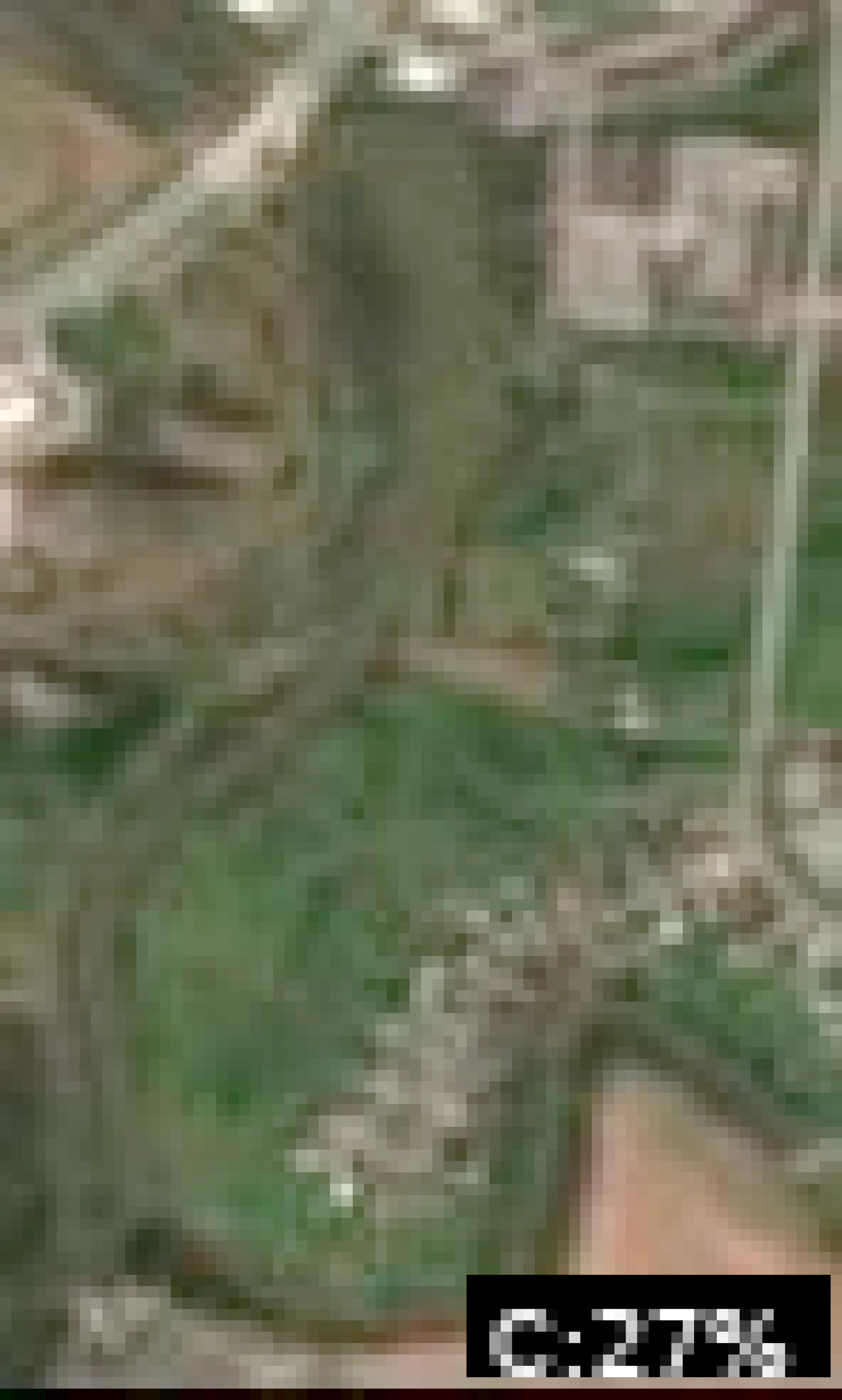
Analyze Satellite Imagery
Sterling Farmer Lake Satellite Analysis - March 01, 2026 (46°F, Winter/Pre-Spawn Focus)
1. LAKE OVERVIEW (Natural Sections & Landmarks)
Sterling Farmer Lake is a compact, irregularly shaped reservoir oriented roughly north-south, about 1-2 miles long, with a narrow northern neck dividing it into distinct sections.
- Main lake body: Central open water area, widest in the middle with a small island visible near the center.
- Northern section/arm: Narrow arm extending north from the neck, with wooded shores and a few scattered docks.
- Southern section/arm: Wider southern basin with more developed shoreline, including a cluster of houses and docks.
- Major creek arms: Short eastern creek arm visible as a narrow inlet off the main body; no prominent western arm.
- Upper lake vs lower lake: Northern section acts as upper lake (shallower, creek-fed appearance); southern section as lower lake (deeper central basin).
Major landmarks:
- Boat ramp on the western shore of the main lake body, just south of the northern neck (paved area with parking visible).
- Small marina/dock cluster in the southern section's southwest corner (multiple slips and a pier).
- Bridge spanning the narrow neck between northern section and main body.
- Single small island in the main lake body, with shallow flats around it.
- No visible dam; lake appears fed by small creeks.
The lake divides naturally at the northern neck bridge (narrows to ~100 feet wide) and a shallower eastern point separating the creek arm.
2. FINDABLE FISHING SPOTS
Here are 6 high-priority, boat-findable spots based on visible structure like points, docks, color transitions (light tan shallows to medium/dark blue), and creek mouths. Prioritized for winter/pre-spawn: points with deep-water access, channel edges.
-
General Area: Northern section
How to Find It: Launch from the main lake boat ramp, head north through the neck bridge, hug the east shore to the first big point with 3 docks.
What You See: Prominent point jutting west into the arm with docks and a sharp color change from tan shallows to medium blue.
Why Fish It: Point offers transition from shallow flats (spawning potential) to deeper water; docks provide cover near channel.
Best Approach: Anchor or drift the point edge, fan-cast docks and color line with jigs or suspending jerkbaits. -
General Area: Main lake body
How to Find It: From boat ramp, head east across main lake to where the creek arm enters on the eastern shore (narrow V-shaped inlet).
What You See: Creek mouth with dark linear channel line leading into tan flats; surrounded by darker blue water.
Why Fish It: Creek channel provides migration route to shallower spawning flats; visible bends hold fish staging pre-spawn.
Best Approach: Position in the channel mouth, cast into bends and adjacent flats with crankbaits or swimbaits. -
General Area: Main lake body
How to Find It: From boat ramp, go southeast to the small central island, then fish the northwest point of the island.
What You See: Island with rocky/shallow appearance (tan surround), sharp drop to medium blue on northwest side.
Why Fish It: Island points create current breaks and depth transitions; refuge near open water for winter bass.
Best Approach: Circle the island, focus casts on point drop-offs with football jigs or drop shots. -
General Area: Southern section
How to Find It: Head south from main lake past the island, enter southern basin, find the marina on southwest shore, then the point just east of it.
What You See: Point extending north from east of marina, with docks and color shift from light blue to dark blue.
Why Fish It: Steep point with dock cover accesses deep basin; ideal winter hangout with wind protection.
Best Approach: Drift or spot-lock the point, target dock shadows and outer edge with shaky heads. -
General Area: Southern section
How to Find It: In southern basin, hug the east shore south from the main lake connection to the long point with linear laydowns.
What You See: Extended point with dark linear objects (laydowns) from shore into medium blue water.
Why Fish It: Laydowns on point create ambush cover near deeper water; pre-spawn staging area.
Best Approach: Parallel the laydowns with Texas rigs, flip into pockets. -
General Area: Northern section
How to Find It: North through neck bridge, west shore cluster of 4-5 docks near arm's end.
What You See: Tight dock cluster on a subtle point with tan flats transitioning to darker water behind.
Why Fish It: Docks over transition provide overhead cover; channel nearby for winter fish.
Best Approach: Pitch jigs under docks, work outer edges toward deeper color change.
3. VISIBLE FEATURES BY LAKE SECTION
Northern section:
- East shore: Big point with 3 docks and color transition.
- West shore: Cluster of 4-5 docks on subtle point.
- Arm end: Narrow creek-like inlet on northeast.
Main lake body:
- Central: Small island with points on all sides, tan shallows around.
- Eastern shore: Creek arm mouth (V-inlet with dark channel line).
- Western shore: Boat ramp south of neck.
- Neck: Bridge spanning narrow connection.
Southern section:
- Southwest: Marina with pier and slips.
- East of marina: Point with docks and dark blue surround.
- East shore: Long point with laydowns (dark lines).
- Southeast: Protected cove with houses/docks.
Eastern creek arm: Short inlet off main body east shore; dark serpentine line visible, tan flats at mouth.
4. PRACTICAL FISHING GUIDANCE
Suggested fishing progression (winter/46°F - start deep, move shallower as sun warms):
- Start (early morning): Northern section - main east shore point with docks (deep transition, wind-protected).
- Mid-morning: Main lake body - creek mouth or island northwest point (follow fish moving from north).
- Pattern: Fish northern arm early (channel staging), transition to main lake points midday, end in southern basin points (deeper refuge). Use electronics to trace visible color lines/channels.
Navigation between sections:
- Northern to main: South through neck bridge (stay mid-channel).
- Main to southern: Southeast past central island (open water, watch for boats).
- Access eastern creek arm: East from boat ramp, 200 yards offshore to inlet.
- Full loop: Boat ramp → north arm → back through bridge → island → south basin → marina → return west.
Think like a local: "Hit that east point north of the bridge first – docks and color break scream winter bass. If quiet, run to the creek dump east of the ramp." All spots visible on Google Earth or similar for pre-trip planning.
Findings:
-
Sterling Farmer Lake Satellite Analysis - March 01, 2026 (46°F, Winter/Pre-Spawn Focus)
1. LAKE OVERVIEW (Natural Sections & Landmarks)
Sterling Farmer Lake is a compact, irregularly shaped reservoir oriented roughly north-south, about 1-2 miles long, with a narrow northern neck dividing it into distinct sections.
- Main lake body: Central open water area, widest in the middle with a small island visible near the center.
- Northern section/arm: Narrow arm extending north from the neck, with wooded shores and a few scattered docks.
- Southern section/arm: Wider southern basin with more developed shoreline, including a cluster of houses and docks.
- Major creek arms: Short eastern creek arm visible as a narrow inlet off the main body; no prominent western arm.
- Upper lake vs lower lake: Northern section acts as upper lake (shallower, creek-fed appearance); southern section as lower lake (deeper central basin).
Major landmarks:
- Boat ramp on the western shore of the main lake body, just south of the northern neck (paved area with parking visible).
- Small marina/dock cluster in the southern section's southwest corner (multiple slips and a pier).
- Bridge spanning the narrow neck between northern section and main body.
- Single small island in the main lake body, with shallow flats around it.
- No visible dam; lake appears fed by small creeks.
The lake divides naturally at the northern neck bridge (narrows to ~100 feet wide) and a shallower eastern point separating the creek arm.
2. FINDABLE FISHING SPOTS
Here are 6 high-priority, boat-findable spots based on visible structure like points, docks, color transitions (light tan shallows to medium/dark blue), and creek mouths. Prioritized for winter/pre-spawn: points with deep-water access, channel edges.
-
General Area: Northern section
How to Find It: Launch from the main lake boat ramp, head north through the neck bridge, hug the east shore to the first big point with 3 docks.
What You See: Prominent point jutting west into the arm with docks and a sharp color change from tan shallows to medium blue.
Why Fish It: Point offers transition from shallow flats (spawning potential) to deeper water; docks provide cover near channel.
Best Approach: Anchor or drift the point edge, fan-cast docks and color line with jigs or suspending jerkbaits. -
General Area: Main lake body
How to Find It: From boat ramp, head east across main lake to where the creek arm enters on the eastern shore (narrow V-shaped inlet).
What You See: Creek mouth with dark linear channel line leading into tan flats; surrounded by darker blue water.
Why Fish It: Creek channel provides migration route to shallower spawning flats; visible bends hold fish staging pre-spawn.
Best Approach: Position in the channel mouth, cast into bends and adjacent flats with crankbaits or swimbaits. -
General Area: Main lake body
How to Find It: From boat ramp, go southeast to the small central island, then fish the northwest point of the island.
What You See: Island with rocky/shallow appearance (tan surround), sharp drop to medium blue on northwest side.
Why Fish It: Island points create current breaks and depth transitions; refuge near open water for winter bass.
Best Approach: Circle the island, focus casts on point drop-offs with football jigs or drop shots. -
General Area: Southern section
How to Find It: Head south from main lake past the island, enter southern basin, find the marina on southwest shore, then the point just east of it.
What You See: Point extending north from east of marina, with docks and color shift from light blue to dark blue.
Why Fish It: Steep point with dock cover accesses deep basin; ideal winter hangout with wind protection.
Best Approach: Drift or spot-lock the point, target dock shadows and outer edge with shaky heads. -
General Area: Southern section
How to Find It: In southern basin, hug the east shore south from the main lake connection to the long point with linear laydowns.
What You See: Extended point with dark linear objects (laydowns) from shore into medium blue water.
Why Fish It: Laydowns on point create ambush cover near deeper water; pre-spawn staging area.
Best Approach: Parallel the laydowns with Texas rigs, flip into pockets. -
General Area: Northern section
How to Find It: North through neck bridge, west shore cluster of 4-5 docks near arm's end.
What You See: Tight dock cluster on a subtle point with tan flats transitioning to darker water behind.
Why Fish It: Docks over transition provide overhead cover; channel nearby for winter fish.
Best Approach: Pitch jigs under docks, work outer edges toward deeper color change.
3. VISIBLE FEATURES BY LAKE SECTION
Northern section:
- East shore: Big point with 3 docks and color transition.
- West shore: Cluster of 4-5 docks on subtle point.
- Arm end: Narrow creek-like inlet on northeast.
Main lake body:
- Central: Small island with points on all sides, tan shallows around.
- Eastern shore: Creek arm mouth (V-inlet with dark channel line).
- Western shore: Boat ramp south of neck.
- Neck: Bridge spanning narrow connection.
Southern section:
- Southwest: Marina with pier and slips.
- East of marina: Point with docks and dark blue surround.
- East shore: Long point with laydowns (dark lines).
- Southeast: Protected cove with houses/docks.
Eastern creek arm: Short inlet off main body east shore; dark serpentine line visible, tan flats at mouth.
4. PRACTICAL FISHING GUIDANCE
Suggested fishing progression (winter/46°F - start deep, move shallower as sun warms):
- Start (early morning): Northern section - main east shore point with docks (deep transition, wind-protected).
- Mid-morning: Main lake body - creek mouth or island northwest point (follow fish moving from north).
- Pattern: Fish northern arm early (channel staging), transition to main lake points midday, end in southern basin points (deeper refuge). Use electronics to trace visible color lines/channels.
Navigation between sections:
- Northern to main: South through neck bridge (stay mid-channel).
- Main to southern: Southeast past central island (open water, watch for boats).
- Access eastern creek arm: East from boat ramp, 200 yards offshore to inlet.
- Full loop: Boat ramp → north arm → back through bridge → island → south basin → marina → return west.
Think like a local: "Hit that east point north of the bridge first – docks and color break scream winter bass. If quiet, run to the creek dump east of the ramp." All spots visible on Google Earth or similar for pre-trip planning.
Analyze Water Clarity
1. Overall Water Quality Summary
Imagery across both clarity visuals reveals predominantly clear to moderately stained conditions in Sterling Farmer Lake, with dark blue/teal tones dominating the main body (indicating low sediment + low chlorophyll, bottom-left matrix quadrant), interspersed with green patches (moderate chlorophyll + low sediment, bottom-center) and localized yellow/tan areas (high chlorophyll + low sediment or low chlorophyll + high sediment, bottom-right/top-left transitions). General visibility ranges from 15-25+ feet in deep blue zones to 2-8 feet in yellow/tan peripheries, suggesting stable clear water in the core basin grading to algae-influenced or sediment-tinged edges, ideal for targeting clarity breaks.
2. Detailed Clarity Zone Mapping & Characterization (3-5 Key Zones with locations, categories, causes)
Zone 1: Dark Blue/Teal (Low Sediment + Low Chlorophyll, Bottom-Left Quadrant)
- Location: Central main basin, extending from mid-lake westward to the northwestern arm (roughly 60% of lake surface).
- Combined Conditions: Minimal particles + minimal algae = 15-25+ feet visibility; clearest premium conditions visually verifiable by uniform deep blue saturation.
- Tactical Implications: Stealth finesse required; natural presentations excel in this expansive clear core.
- Transition: Sharp edges to green zones northeast.
Zone 2: Green (Moderate Chlorophyll + Low Sediment, Bottom-Center Quadrant)
- Location: Northeastern cove and eastern shoreline pockets, clustered around irregular protrusions (visible as brighter emerald patches against blue).
- Combined Conditions: Algae present but no sediment = 8-15 feet visibility; productive clear water with slight green tint from chlorophyll.
- Tactical Implications: Mix natural/bright colors, standard retrieves; algae edges hold baitfish.
- Transition: Gradual fade into yellow northeast and sharp to teal centrally.
Zone 3: Yellow/Tan (High Chlorophyll + Low Sediment transitioning to Low Chlorophyll + High Sediment, Bottom-Right/Top-Left Quadrants)
- Location: Southern shallows and southwestern inlet arm (prominent pale yellow/tan blobs in second image, aligning with greenish-yellow hints in first).
- Combined Conditions: Heavy algae or stirred sediment = 2-8 feet visibility; stained by algae bloom or runoff, no extreme murk.
- Tactical Implications: Vibration and bright colors needed; power-finesse hybrid at edges.
- Transition: Distinct mudline-like boundary northward into green/blue.
Zone 4: Minor Brown/Tan Flecks (Low Chlorophyll + High Sediment, Top-Left Quadrant)
- Location: Scattered along southernmost tip and western cove edges (tan highlights in second image).
- Combined Conditions: High sediment, minimal algae = 2-6 feet visibility; muddy from wind/runoff.
- Tactical Implications: Maximum noise/vibration; short-range power fishing.
3. Turbidity/Algae Sources & Transition Zones Analysis
Source Identification (Visual): Yellow/tan concentrations in the southern shallows and southwestern arm suggest sediment sources from wind-stirred flats or minor inflows (tan flecks align with shallow contours), while green/yellow patches in the northeast cove indicate protected algae growth (chlorophyll hotspots shielded from main currents). No extreme dark brown/red (top-right) visible, limiting worst-case murk.
Clarity Breaks/Edges:
- Sharp "mudline" (tan/yellow meeting dark blue/teal) runs northwest-southeast across the southern third, ~1/3 lake width—prime ambush point as clearer water fish invade stained edges.
- Gradual green-to-yellow shift along eastern shoreline (northeast cove to main basin), spanning 200-300 yards—bait concentration zone where algae edges meet clear water.
- Teal-to-green breaks in northwestern arm, subtle but linear along contours—high potential for suspended fish. These edges signify productivity walls where forage gathers, drawing predators for reaction strikes.
4. Species-Specific Clarity Strategy (Recommendations tied to zones)
- Bass: Target Zone 3 yellow/tan southern shallows and transitions (mudline edges) for aggressive reaction bites in 2-8ft vis; patrol Zone 2 green northeastern cove for ambush along algae edges (8-15ft vis, shad schools visible).
- Crappie/Walleye: Suspend in Zone 1 dark blue/teal central basin (15+ft vis, northwestern arm)—sight-feeding optimal; finesse edges of Zone 2 green pockets for cover-oriented holds.
- Catfish: Bottom-bounce Zone 4 tan flecks in southwestern cove (2-6ft vis, high sediment hides scent trails near structure). Clarity breaks (e.g., southern mudline, eastern green-yellow shift) are universal hotspots—bass/crappie stack on the clearer side ambushing from stained water.
5. Tactical Fishing Adjustments (Lures/Presentations tied to zones)
Zone 1 (Dark Blue/Teal, Clear): Natural colors (green pumpkin, watermelon seed soft plastics, shad jerkbaits); finesse presentations (slow Ned rigs, drop shots); long casts (40+yds), fluorocarbon 8-12lb, spot-on-the-spot stealth—minimal trolling motor noise. Zone 2 (Green, Mod Algae Clear): Mix natural/bright (chartreuse jigheads, white spinnerbaits); standard retrieves with pauses (suspending jerkbaits); moderate casts (20-30yds), 12lb fluoro/mono. Zone 3/4 (Yellow/Tan, Stained/Muddy): High-contrast/bright (chartreuse/white chatterbaits, black/blue lipless cranks, orange big worms); vibration-heavy fast retrieves (rattles critical); short casts (10-20yds), 15-20lb braid/mono, aggressive boat positioning. Clarity Breaks: Fish with reaction baits (fast spinnerbaits along mudline, parallel casts to eastern green-yellow wall)—alternate sides to trigger crossings; downsize 25% (e.g., 1/4oz vs 1/2oz) for 46°F cold, slow overall retrieves emphasizing vibration/scent in low-vis edges.
6. Seasonal Context (Interpretation of visual patterns)
Visuals show stable clear core (persistent dark blue/teal basin) resilient to peripheral staining, with localized green/yellow algae and tan sediment suggesting minor wind/runoff influence rather than major bloom or flood—appears typical for cooler transitions (e.g., consistent with early cold fronts stirring edges without basin-wide turnover). Northeastern green patches indicate sheltered productivity holding through clarity shifts, while southern tan limits suggest recent shallow disturbance but no widespread degradation.
Findings:
-
1. Overall Water Quality Summary
Imagery across both clarity visuals reveals predominantly clear to moderately stained conditions in Sterling Farmer Lake, with dark blue/teal tones dominating the main body (indicating low sediment + low chlorophyll, bottom-left matrix quadrant), interspersed with green patches (moderate chlorophyll + low sediment, bottom-center) and localized yellow/tan areas (high chlorophyll + low sediment or low chlorophyll + high sediment, bottom-right/top-left transitions). General visibility ranges from 15-25+ feet in deep blue zones to 2-8 feet in yellow/tan peripheries, suggesting stable clear water in the core basin grading to algae-influenced or sediment-tinged edges, ideal for targeting clarity breaks.
2. Detailed Clarity Zone Mapping & Characterization (3-5 Key Zones with locations, categories, causes)
Zone 1: Dark Blue/Teal (Low Sediment + Low Chlorophyll, Bottom-Left Quadrant)
- Location: Central main basin, extending from mid-lake westward to the northwestern arm (roughly 60% of lake surface).
- Combined Conditions: Minimal particles + minimal algae = 15-25+ feet visibility; clearest premium conditions visually verifiable by uniform deep blue saturation.
- Tactical Implications: Stealth finesse required; natural presentations excel in this expansive clear core.
- Transition: Sharp edges to green zones northeast.
Zone 2: Green (Moderate Chlorophyll + Low Sediment, Bottom-Center Quadrant)
- Location: Northeastern cove and eastern shoreline pockets, clustered around irregular protrusions (visible as brighter emerald patches against blue).
- Combined Conditions: Algae present but no sediment = 8-15 feet visibility; productive clear water with slight green tint from chlorophyll.
- Tactical Implications: Mix natural/bright colors, standard retrieves; algae edges hold baitfish.
- Transition: Gradual fade into yellow northeast and sharp to teal centrally.
Zone 3: Yellow/Tan (High Chlorophyll + Low Sediment transitioning to Low Chlorophyll + High Sediment, Bottom-Right/Top-Left Quadrants)
- Location: Southern shallows and southwestern inlet arm (prominent pale yellow/tan blobs in second image, aligning with greenish-yellow hints in first).
- Combined Conditions: Heavy algae or stirred sediment = 2-8 feet visibility; stained by algae bloom or runoff, no extreme murk.
- Tactical Implications: Vibration and bright colors needed; power-finesse hybrid at edges.
- Transition: Distinct mudline-like boundary northward into green/blue.
Zone 4: Minor Brown/Tan Flecks (Low Chlorophyll + High Sediment, Top-Left Quadrant)
- Location: Scattered along southernmost tip and western cove edges (tan highlights in second image).
- Combined Conditions: High sediment, minimal algae = 2-6 feet visibility; muddy from wind/runoff.
- Tactical Implications: Maximum noise/vibration; short-range power fishing.
3. Turbidity/Algae Sources & Transition Zones Analysis
Source Identification (Visual): Yellow/tan concentrations in the southern shallows and southwestern arm suggest sediment sources from wind-stirred flats or minor inflows (tan flecks align with shallow contours), while green/yellow patches in the northeast cove indicate protected algae growth (chlorophyll hotspots shielded from main currents). No extreme dark brown/red (top-right) visible, limiting worst-case murk.
Clarity Breaks/Edges:
- Sharp "mudline" (tan/yellow meeting dark blue/teal) runs northwest-southeast across the southern third, ~1/3 lake width—prime ambush point as clearer water fish invade stained edges.
- Gradual green-to-yellow shift along eastern shoreline (northeast cove to main basin), spanning 200-300 yards—bait concentration zone where algae edges meet clear water.
- Teal-to-green breaks in northwestern arm, subtle but linear along contours—high potential for suspended fish. These edges signify productivity walls where forage gathers, drawing predators for reaction strikes.
4. Species-Specific Clarity Strategy (Recommendations tied to zones)
- Bass: Target Zone 3 yellow/tan southern shallows and transitions (mudline edges) for aggressive reaction bites in 2-8ft vis; patrol Zone 2 green northeastern cove for ambush along algae edges (8-15ft vis, shad schools visible).
- Crappie/Walleye: Suspend in Zone 1 dark blue/teal central basin (15+ft vis, northwestern arm)—sight-feeding optimal; finesse edges of Zone 2 green pockets for cover-oriented holds.
- Catfish: Bottom-bounce Zone 4 tan flecks in southwestern cove (2-6ft vis, high sediment hides scent trails near structure). Clarity breaks (e.g., southern mudline, eastern green-yellow shift) are universal hotspots—bass/crappie stack on the clearer side ambushing from stained water.
5. Tactical Fishing Adjustments (Lures/Presentations tied to zones)
Zone 1 (Dark Blue/Teal, Clear): Natural colors (green pumpkin, watermelon seed soft plastics, shad jerkbaits); finesse presentations (slow Ned rigs, drop shots); long casts (40+yds), fluorocarbon 8-12lb, spot-on-the-spot stealth—minimal trolling motor noise. Zone 2 (Green, Mod Algae Clear): Mix natural/bright (chartreuse jigheads, white spinnerbaits); standard retrieves with pauses (suspending jerkbaits); moderate casts (20-30yds), 12lb fluoro/mono. Zone 3/4 (Yellow/Tan, Stained/Muddy): High-contrast/bright (chartreuse/white chatterbaits, black/blue lipless cranks, orange big worms); vibration-heavy fast retrieves (rattles critical); short casts (10-20yds), 15-20lb braid/mono, aggressive boat positioning. Clarity Breaks: Fish with reaction baits (fast spinnerbaits along mudline, parallel casts to eastern green-yellow wall)—alternate sides to trigger crossings; downsize 25% (e.g., 1/4oz vs 1/2oz) for 46°F cold, slow overall retrieves emphasizing vibration/scent in low-vis edges.
6. Seasonal Context (Interpretation of visual patterns)
Visuals show stable clear core (persistent dark blue/teal basin) resilient to peripheral staining, with localized green/yellow algae and tan sediment suggesting minor wind/runoff influence rather than major bloom or flood—appears typical for cooler transitions (e.g., consistent with early cold fronts stirring edges without basin-wide turnover). Northeastern green patches indicate sheltered productivity holding through clarity shifts, while southern tan limits suggest recent shallow disturbance but no widespread degradation.
How this was synthesized
Professional fishing guide analysis integrating 6 tools: analyze_weather_conditions, analyze_pressure_trends, analyze_solunar_timing, analyze_thermal_patterns, analyze_satellite_imagery, analyze_water_clarity. User request: 'Analyze the water clarity for Sterling Farmer Lake. Identify clear vs. murky areas and suggest fishing strategies based on clarity conditions.'. Synthesis generated comprehensive plan with professional recommendations.