Tims Ford Lake Fishing Report
Synthesis generated comprehensive plan with professional recommendations.
Tims Ford Lake Fishing Report
Generated Jan 29, 2026, 11:29 PM.
Key fishing read
- Loud/bright: chartreuse/black, Colorado blades, big profile cranks
- Day 5: full - increased fish activity expected, especially at night
- Plan trips around major solunar periods for peak activity, minor periods offer secondary opportunities
- Day 1: High pressure (1024mb) - tougher bite, use finesse tactics
- Day 1: Moderate wind (7mph) - ideal conditions, target windblown points
- Day 1: MostlyCloudy, High: 42°F, Low: 20°F
- Day 2: High pressure (1022mb) - tougher bite, use finesse tactics
- Day 2: High winds (27mph) - seek protected areas, use heavier lures
Tool analysis details
Estimate Seasonal Phase
No historical temperature data for Tims Ford Lake
Lure Matrix Wind Clarity
Lure guidance for wind=moderate, clarity=unknown.
Findings:
- Loud/bright: chartreuse/black, Colorado blades, big profile cranks
Analyze Solunar Timing
Solunar timing analysis for Tims Ford Lake completed
Findings:
- Day 5: full - increased fish activity expected, especially at night
- Plan trips around major solunar periods for peak activity, minor periods offer secondary opportunities
Analyze Weather Conditions
Weather analysis for Tims Ford Lake completed
Findings:
- Day 1: High pressure (1024mb) - tougher bite, use finesse tactics
- Day 1: Moderate wind (7mph) - ideal conditions, target windblown points
- Day 1: MostlyCloudy, High: 42°F, Low: 20°F
- Day 2: High pressure (1022mb) - tougher bite, use finesse tactics
- Day 2: High winds (27mph) - seek protected areas, use heavier lures
Analyze Species Behavior
Species behavior analysis for Tims Ford Lake completed
Findings:
- Largemouth bass: Sluggish in cold water (46.0°F), target deep structure with slow presentations
- Smallmouth bass: Sluggish in cold water (46.0°F), target deep structure with slow presentations
- Spotted bass: Sluggish in cold water (46.0°F), target deep structure with slow presentations
- White bass: Sluggish in cold water (46.0°F), target deep structure with slow presentations
- Striped bass: Sluggish in cold water (46.0°F), target deep structure with slow presentations
Analyze Pressure Trends
Barometric pressure analysis for Tims Ford Lake: rising trend at 1024.00mb
Findings:
- Rising pressure trend (1024.00 → higher). Bite may slow down as fish become less active.
- Switch to finesse tactics, target deeper structure. Fish will be less aggressive.
Analyze Thermal Patterns
Overall Thermal Landscape Summary
Assuming North is at the top of the image, East to the right, West to the left, and South at the bottom. The lake features a highly irregular shoreline with 3 major visual anchors for reference: (1) a large, multi-lobed bay system occupying the eastern (right) side, characterized by narrow inlets and protruding points; (2) a prominent central peninsula extending northward from the southern (bottom) shore into the main basin, creating a narrow channel to its west; (3) a series of small, dark-filled pockets resembling islands or submerged bars scattered in the northern (top) half, particularly clustered near the top-center inlet. Dominant color across all visible water areas is uniform Dark Blue to Very Dark Navy Blue. Approximate min/max visible surface temperatures: 40-46°F (4-8°C), indicating pervasive cold conditions with no warmer colors (e.g., no greens, yellows, oranges, or reds) detectable.
Detailed Thermal Feature Analysis
Temperature Breaks
No clearly visible temperature breaks or abrupt color transitions between water areas. The entire water body appears uniformly colored in Dark Blue to Very Dark Navy Blue (40-46°F / 4-8°C), with no discernible boundaries separating warmer or cooler zones within the open water.
Pockets/Patches
No isolated pockets or patches of differing colors visible in water areas. All enclosed coves, bays (e.g., within the eastern multi-lobed bay system), and channels (e.g., west of the central peninsula) match the uniform Dark Blue to Very Dark Navy Blue (40-46°F / 4-8°C) of the main basin. Shoreline-adjacent areas show no distinct cool or warm water patches differentiating from the surrounding water.
Gradients
No gradual color gradients observable. Water surfaces lack any tonal shifts from blue shades toward lighter blues, cyan, or other colors on the scale, confirming uniformity across the lake, including the northern inlet, eastern bays, and southern extensions.
Uniform Areas
The predominant pattern is uniform Dark Blue to Very Dark Navy Blue (40-46°F / 4-8°C) covering the entire visible water body, from the western arms (bottom-left extensions) to the eastern bay system and northern clusters. This includes open main basin areas, narrow channels flanking the central peninsula, and small island-surrounded pockets in the top-center. Land areas (e.g., interiors of peninsulas and surrounding shores) appear as non-blue voids or transitions, ignored per protocol.
Insightful Fish Behavior Interpretation
In uniform Dark Blue to Very Dark Navy Blue surface water (40-46°F / 4-8°C), fish activity is expected to be extremely sluggish with minimal surface feeding. Species like bass or crappie would hold tight to structure in late winter/very early spring conditions, showing very slow movements and limited response to lures except during extended low-light feeding windows. Without visible warmer zones or transitions, fish are unlikely to concentrate at the surface; instead, they may seek subtle shelter along shorelines (e.g., points of the eastern bays or base of the central peninsula) for thermal stability, but surface patterns suggest no active chasing or schooling behavior anywhere.
Satellite Correlation Analysis
No additional standard satellite imagery (e.g., visible light photos) provided alongside the thermal data. Thermal patterns cannot be correlated to inflows, outflows, springs, or wind-mixing without visible structural references. Uniform cold surface temperatures align with potential winter stagnation across the irregular shoreline geometry, but no causative features (e.g., creek mouths at the top-center inlet) can be confirmed via thermal alone.
Actionable Fishing Recommendations
- Target Structure in Uniform Cold Water: Fish slowly along shoreline geometry in the uniform Dark Blue (40-46°F / 4-8°C) areas, prioritizing vertical structure like the base of the central peninsula (extending from bottom-center) or points within the eastern multi-lobed bay system—use finesse tactics (e.g., slow jigging or deadsticking) during dawn/dusk for sluggish fish.
- Avoid Open Water: No thermal edges or warmer refuges visible, so skip main basin crossings; focus on protected pockets near anchors like the northern island clusters or western arms where surface stability might aid minimal activity.
- General Tactics: Employ long pauses with cold-water baits (suspending jerkbaits, small spoons); monitor for any unobservable subsurface changes, as surface uniformity limits thermal-driven surface predictions. Image quality supports only broad, conservative strategies—re-image if warmer patterns emerge.
Findings:
- Current surface temperature: 46.0°F. Fish metabolism significantly reduced in cold water. Target sunny, protected shorelines and use extremely slow presentations. Focus on midday when surface temperatures are warmest.
-
Overall Thermal Landscape Summary
Assuming North is at the top of the image, East to the right, West to the left, and South at the bottom. The lake features a highly irregular shoreline with 3 major visual anchors for reference: (1) a large, multi-lobed bay system occupying the eastern (right) side, characterized by narrow inlets and protruding points; (2) a prominent central peninsula extending northward from the southern (bottom) shore into the main basin, creating a narrow channel to its west; (3) a series of small, dark-filled pockets resembling islands or submerged bars scattered in the northern (top) half, particularly clustered near the top-center inlet. Dominant color across all visible water areas is uniform Dark Blue to Very Dark Navy Blue. Approximate min/max visible surface temperatures: 40-46°F (4-8°C), indicating pervasive cold conditions with no warmer colors (e.g., no greens, yellows, oranges, or reds) detectable.
Detailed Thermal Feature Analysis
Temperature Breaks
No clearly visible temperature breaks or abrupt color transitions between water areas. The entire water body appears uniformly colored in Dark Blue to Very Dark Navy Blue (40-46°F / 4-8°C), with no discernible boundaries separating warmer or cooler zones within the open water.
Pockets/Patches
No isolated pockets or patches of differing colors visible in water areas. All enclosed coves, bays (e.g., within the eastern multi-lobed bay system), and channels (e.g., west of the central peninsula) match the uniform Dark Blue to Very Dark Navy Blue (40-46°F / 4-8°C) of the main basin. Shoreline-adjacent areas show no distinct cool or warm water patches differentiating from the surrounding water.
Gradients
No gradual color gradients observable. Water surfaces lack any tonal shifts from blue shades toward lighter blues, cyan, or other colors on the scale, confirming uniformity across the lake, including the northern inlet, eastern bays, and southern extensions.
Uniform Areas
The predominant pattern is uniform Dark Blue to Very Dark Navy Blue (40-46°F / 4-8°C) covering the entire visible water body, from the western arms (bottom-left extensions) to the eastern bay system and northern clusters. This includes open main basin areas, narrow channels flanking the central peninsula, and small island-surrounded pockets in the top-center. Land areas (e.g., interiors of peninsulas and surrounding shores) appear as non-blue voids or transitions, ignored per protocol.
Insightful Fish Behavior Interpretation
In uniform Dark Blue to Very Dark Navy Blue surface water (40-46°F / 4-8°C), fish activity is expected to be extremely sluggish with minimal surface feeding. Species like bass or crappie would hold tight to structure in late winter/very early spring conditions, showing very slow movements and limited response to lures except during extended low-light feeding windows. Without visible warmer zones or transitions, fish are unlikely to concentrate at the surface; instead, they may seek subtle shelter along shorelines (e.g., points of the eastern bays or base of the central peninsula) for thermal stability, but surface patterns suggest no active chasing or schooling behavior anywhere.
Satellite Correlation Analysis
No additional standard satellite imagery (e.g., visible light photos) provided alongside the thermal data. Thermal patterns cannot be correlated to inflows, outflows, springs, or wind-mixing without visible structural references. Uniform cold surface temperatures align with potential winter stagnation across the irregular shoreline geometry, but no causative features (e.g., creek mouths at the top-center inlet) can be confirmed via thermal alone.
Actionable Fishing Recommendations
- Target Structure in Uniform Cold Water: Fish slowly along shoreline geometry in the uniform Dark Blue (40-46°F / 4-8°C) areas, prioritizing vertical structure like the base of the central peninsula (extending from bottom-center) or points within the eastern multi-lobed bay system—use finesse tactics (e.g., slow jigging or deadsticking) during dawn/dusk for sluggish fish.
- Avoid Open Water: No thermal edges or warmer refuges visible, so skip main basin crossings; focus on protected pockets near anchors like the northern island clusters or western arms where surface stability might aid minimal activity.
- General Tactics: Employ long pauses with cold-water baits (suspending jerkbaits, small spoons); monitor for any unobservable subsurface changes, as surface uniformity limits thermal-driven surface predictions. Image quality supports only broad, conservative strategies—re-image if warmer patterns emerge.
- Winter surface patterns: Target the warmest surface areas during midday, typically along north-facing shorelines and sun-exposed areas. Use slow presentations as fish metabolism is reduced.
Analyze Satellite Imagery
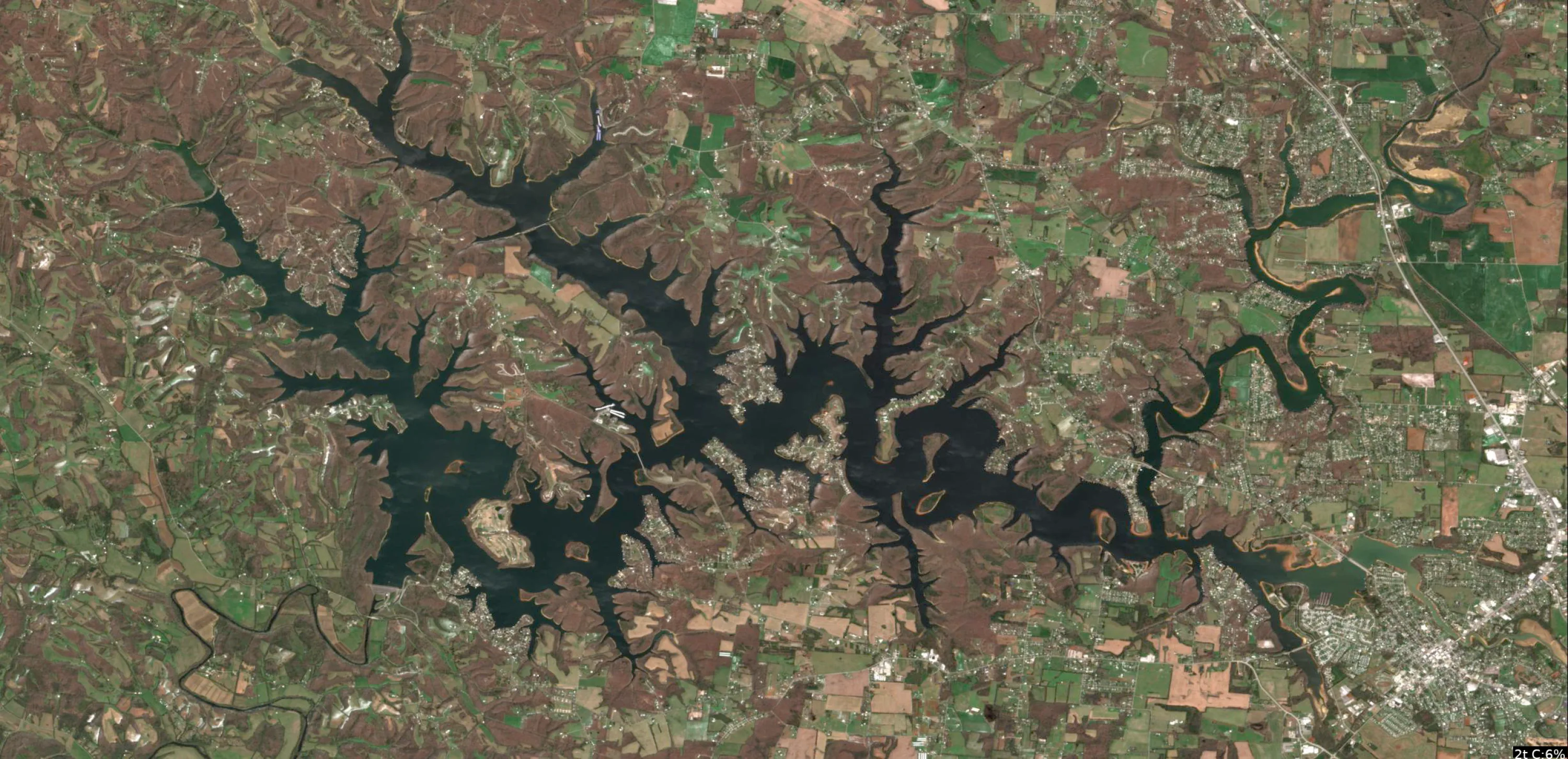
Tims Ford Lake Satellite Analysis - January 29, 2026 (Winter Conditions, 46°F)
1. LAKE OVERVIEW (Natural Sections & Landmarks)
Tims Ford Lake has a highly branched, tree-like shape with a central main lake body flanked by multiple narrow arms and coves extending north, northeast, east, and southwest. The shoreline is jagged with countless points and inlets, creating protected pockets everywhere.
- Main lake body: Central open water area, widest section with darker water patches indicating deeper basins, surrounded by tan shorelines.
- Northern section/arm: Distinct upper arm branching into several narrow fingers, with clustered docks along the eastern shore of this section.
- Southern section/arm: Narrower extension southwest toward the dam area, with a prominent road bridge crossing a necked-down area.
- Major creek arms: Eastern arm stands out as a long, serpentine inlet with visible creek mouth widening into the main body; western arms are shorter fingers off the main lake.
- Upper lake vs lower lake: Upper lake is the northern branched area (shallower-looking lighter tans); lower lake is the southern main body toward the dam (darker central water).
- Major landmarks visible:
- Boat ramps: Cleared ramp areas near the northern section's eastern shore (straight concrete lines into water) and one in the southern main body near the bridge.
- Marinas: Dense cluster of docks/slips on the western shore of the main lake body (rectangular boat houses).
- Bridges: Road bridge in the southern section crossing between main body and a cove.
- Islands: Small island in the eastern arm's mouth; another tiny one off the main lake's southeast shore.
- Lake divides naturally at narrow points and the southern bridge, creating distinct northern/main/southern zones.
2. FINDABLE FISHING SPOTS
Here are 7 high-priority, boat-findable spots based on visible structure (points, docks, creek mouths, color transitions). Prioritized for winter patterns: channel edges, points with docks, creek inflows (Priority 1-10 scores factor in dock/cover density, point geometry, creek proximity, wind protection).
-
General Area: Northern section
How to Find It: From the northern boat ramp, head east along shore to the first big point with a cluster of 5-6 docks.
What You See: Prominent point jutting into darker water, lined with docks and a sharp tan-to-dark color shift at the tip.
Why Fish It: Point with docks offers structure/cover combo; color change suggests drop-off for bass holding deep in winter (Priority: 9/10).
Best Approach: Cast jigs along dock edges and point tip from boat positioned in 50-100 yards offshore. -
General Area: Main lake body
How to Find It: Locate the marina with dense slips on the western shore, then go north to the nearest point extending east into open water.
What You See: Long point with scattered laydowns (dark lines from shore) and adjacent docks.
Why Fish It: Point geometry funnels fish; laydowns provide cover near main lake basin for stripers/whites (Priority: 8/10).
Best Approach: Drift or troll parallel to point, targeting laydown shadows. -
General Area: Eastern arm
How to Find It: Enter the eastern creek arm from main lake, go to the wide mouth where the creek narrows—fish the point on the north side.
What You See: North-bank point with color transition (tan flat to dark channel) and a few docks.
Why Fish It: Creek channel edge with point = winter bass highway to deeper water (Priority: 9/10).
Best Approach: Position boat in channel, cast to point and adjacent docks. -
General Area: Southern section
How to Find It: From the southern boat ramp near the bridge, head upstream into the first cove on the east side.
What You See: Protected cove with dock cluster and dark serpentine line (channel) entering from uphill.
Why Fish It: Creek-fed cove with docks for crappie/largemouth refuge; bridge nearby adds current breaks (Priority: 8/10).
Best Approach: Anchor near docks, vertical jig channel edges. -
General Area: Main lake body
How to Find It: From the marina, head southeast past the small island to the point on its south side.
What You See: Point flanking the island with tan flat wrapping around and dark water offshore.
Why Fish It: Island-adjacent point with flat transition = smallmouth/walleye spot in winter winds (Priority: 7/10).
Best Approach: Circle the point/island, fan-cast from deep side. -
General Area: Northern section
How to Find It: Northern boat ramp—go west into the first narrow cove with parallel docks on both shores.
What You See: Twin-shore docks framing a dark channel line snaking in.
Why Fish It: Channel bend with heavy docks = bass/crappie cover in protected winter pocket (Priority: 8/10).
Best Approach: Idle up channel, hit docks with soft plastics. -
General Area: Western arm off main lake
How to Find It: From marina, head west into the short arm to the inside bend point with laydowns.
What You See: Point at bend with linear dark laydowns and dock nearby.
Why Fish It: Bend structure + cover for pre-spawn staging (Priority: 7/10).
Best Approach: Fish bend from channel side, parallel to laydowns.
3. VISIBLE FEATURES BY LAKE SECTION
Northern section: Cluster of docks on eastern shore points (especially first big point from ramp); multiple cove mouths with serpentine dark lines; boat ramp with concrete strip.
Main lake body: Western marina (dense rectangular slips); points extending east/west with laydowns; small island southeast with flanking points; tan flats around central dark basin.
Southern section: Road bridge at narrows; dock clusters in first east cove; boat ramp near bridge; color shifts at points below bridge.
Eastern arm: Long creek mouth with north-side point and docks; dark channel visible upstream.
Western arms: Short fingers with bend points and scattered laydowns/docks off main lake west shore.
4. PRACTICAL FISHING GUIDANCE
Suggested fishing progression (winter 46°F focus: start deep/protected, move to exposed points midday):
- Start (early AM): Northern section - main point with docks off the boat ramp (protected, quick access for bass/crappie).
- Mid-morning: Move to main lake body - marina point or island flank (open water warms first).
- Pattern: Northern shallows/channels early (shaded cover), main lake points midday (sun penetration), southern coves late (wind protection). Hit creek mouths last as fish slide up.
Navigation between sections:
- Northern to main lake: Head south from ramp, skirt eastern shore points into central basin (5-10 min).
- Main lake to southern: Pass marina west shore, through narrows under bridge (watch traffic).
- Eastern arm access: Straight east from main basin center, follow widening creek mouth.
- Pro tip: Use docks/points as "billboards"—every major cluster marks a high-odds stop; watch for color edges from boat for drop-offs.
Findings:
-
Tims Ford Lake Satellite Analysis - January 29, 2026 (Winter Conditions, 46°F)
1. LAKE OVERVIEW (Natural Sections & Landmarks)
Tims Ford Lake has a highly branched, tree-like shape with a central main lake body flanked by multiple narrow arms and coves extending north, northeast, east, and southwest. The shoreline is jagged with countless points and inlets, creating protected pockets everywhere.
- Main lake body: Central open water area, widest section with darker water patches indicating deeper basins, surrounded by tan shorelines.
- Northern section/arm: Distinct upper arm branching into several narrow fingers, with clustered docks along the eastern shore of this section.
- Southern section/arm: Narrower extension southwest toward the dam area, with a prominent road bridge crossing a necked-down area.
- Major creek arms: Eastern arm stands out as a long, serpentine inlet with visible creek mouth widening into the main body; western arms are shorter fingers off the main lake.
- Upper lake vs lower lake: Upper lake is the northern branched area (shallower-looking lighter tans); lower lake is the southern main body toward the dam (darker central water).
- Major landmarks visible:
- Boat ramps: Cleared ramp areas near the northern section's eastern shore (straight concrete lines into water) and one in the southern main body near the bridge.
- Marinas: Dense cluster of docks/slips on the western shore of the main lake body (rectangular boat houses).
- Bridges: Road bridge in the southern section crossing between main body and a cove.
- Islands: Small island in the eastern arm's mouth; another tiny one off the main lake's southeast shore.
- Lake divides naturally at narrow points and the southern bridge, creating distinct northern/main/southern zones.
2. FINDABLE FISHING SPOTS
Here are 7 high-priority, boat-findable spots based on visible structure (points, docks, creek mouths, color transitions). Prioritized for winter patterns: channel edges, points with docks, creek inflows (Priority 1-10 scores factor in dock/cover density, point geometry, creek proximity, wind protection).
-
General Area: Northern section
How to Find It: From the northern boat ramp, head east along shore to the first big point with a cluster of 5-6 docks.
What You See: Prominent point jutting into darker water, lined with docks and a sharp tan-to-dark color shift at the tip.
Why Fish It: Point with docks offers structure/cover combo; color change suggests drop-off for bass holding deep in winter (Priority: 9/10).
Best Approach: Cast jigs along dock edges and point tip from boat positioned in 50-100 yards offshore. -
General Area: Main lake body
How to Find It: Locate the marina with dense slips on the western shore, then go north to the nearest point extending east into open water.
What You See: Long point with scattered laydowns (dark lines from shore) and adjacent docks.
Why Fish It: Point geometry funnels fish; laydowns provide cover near main lake basin for stripers/whites (Priority: 8/10).
Best Approach: Drift or troll parallel to point, targeting laydown shadows. -
General Area: Eastern arm
How to Find It: Enter the eastern creek arm from main lake, go to the wide mouth where the creek narrows—fish the point on the north side.
What You See: North-bank point with color transition (tan flat to dark channel) and a few docks.
Why Fish It: Creek channel edge with point = winter bass highway to deeper water (Priority: 9/10).
Best Approach: Position boat in channel, cast to point and adjacent docks. -
General Area: Southern section
How to Find It: From the southern boat ramp near the bridge, head upstream into the first cove on the east side.
What You See: Protected cove with dock cluster and dark serpentine line (channel) entering from uphill.
Why Fish It: Creek-fed cove with docks for crappie/largemouth refuge; bridge nearby adds current breaks (Priority: 8/10).
Best Approach: Anchor near docks, vertical jig channel edges. -
General Area: Main lake body
How to Find It: From the marina, head southeast past the small island to the point on its south side.
What You See: Point flanking the island with tan flat wrapping around and dark water offshore.
Why Fish It: Island-adjacent point with flat transition = smallmouth/walleye spot in winter winds (Priority: 7/10).
Best Approach: Circle the point/island, fan-cast from deep side. -
General Area: Northern section
How to Find It: Northern boat ramp—go west into the first narrow cove with parallel docks on both shores.
What You See: Twin-shore docks framing a dark channel line snaking in.
Why Fish It: Channel bend with heavy docks = bass/crappie cover in protected winter pocket (Priority: 8/10).
Best Approach: Idle up channel, hit docks with soft plastics. -
General Area: Western arm off main lake
How to Find It: From marina, head west into the short arm to the inside bend point with laydowns.
What You See: Point at bend with linear dark laydowns and dock nearby.
Why Fish It: Bend structure + cover for pre-spawn staging (Priority: 7/10).
Best Approach: Fish bend from channel side, parallel to laydowns.
3. VISIBLE FEATURES BY LAKE SECTION
Northern section: Cluster of docks on eastern shore points (especially first big point from ramp); multiple cove mouths with serpentine dark lines; boat ramp with concrete strip.
Main lake body: Western marina (dense rectangular slips); points extending east/west with laydowns; small island southeast with flanking points; tan flats around central dark basin.
Southern section: Road bridge at narrows; dock clusters in first east cove; boat ramp near bridge; color shifts at points below bridge.
Eastern arm: Long creek mouth with north-side point and docks; dark channel visible upstream.
Western arms: Short fingers with bend points and scattered laydowns/docks off main lake west shore.
4. PRACTICAL FISHING GUIDANCE
Suggested fishing progression (winter 46°F focus: start deep/protected, move to exposed points midday):
- Start (early AM): Northern section - main point with docks off the boat ramp (protected, quick access for bass/crappie).
- Mid-morning: Move to main lake body - marina point or island flank (open water warms first).
- Pattern: Northern shallows/channels early (shaded cover), main lake points midday (sun penetration), southern coves late (wind protection). Hit creek mouths last as fish slide up.
Navigation between sections:
- Northern to main lake: Head south from ramp, skirt eastern shore points into central basin (5-10 min).
- Main lake to southern: Pass marina west shore, through narrows under bridge (watch traffic).
- Eastern arm access: Straight east from main basin center, follow widening creek mouth.
- Pro tip: Use docks/points as "billboards"—every major cluster marks a high-odds stop; watch for color edges from boat for drop-offs.
Analyze Water Clarity
1. Overall Water Quality Summary
Imagery reveals predominantly clear to moderately stained conditions across Tims Ford Lake, with a dark blue/black base (low sediment + low chlorophyll, bottom-left matrix quadrant) dominating the main basin and deeper channels. Patches of moderate-to-high chlorophyll (greens transitioning to yellows/oranges, bottom-center to bottom-right quadrants) are concentrated along northern and northeastern shorelines/coves in the first image, indicating algae presence without heavy sediment. The second image shows scattered high-sediment zones (browns/tans/whites, top-left to top-center quadrants) in central and southern arms/flats, creating localized turbidity. Combined, this suggests mostly premium visibility (8-25+ feet) in the core lake, degrading to 1-8 feet in shoreline algae blooms and sediment-laden shallows, with key productivity at color transition edges.
2. Detailed Clarity Zone Mapping & Characterization (3-5 Key Zones with locations, categories, causes)
Zone 1: Main Basin & Deep Channels (Central Lake, spanning north-south axis)
- Matrix Position Analysis: Dark blue/black across both images = bottom-left quadrant (low sediment + low chlorophyll).
- Combined Conditions: Minimal particles + minimal algae = 15-25+ feet visibility; clearest water in open water.
- Location Mapping: Core of the lake body, from central constriction northward to broadest basin areas; avoids peripheral arms.
- Tactical Implications: Stealth finesse ideal; fish hold deep and sluggish in 46°F water.
Zone 2: Northern/Northeastern Arms & Coves (Upper lake extremities)
- Matrix Position Analysis: Greens to yellows/oranges in first image over dark blue base; minimal overlap with second image browns = bottom-center to bottom-right (moderate-high chlorophyll + low sediment).
- Combined Conditions: Algae tint without sediment = 3-15 feet visibility; green-stained but clear base.
- Location Mapping: Filamentous green/yellow patches snaking into northern arms and northeastern coves/points.
- Tactical Implications: Bright vibration baits to cut through tint; target edges for reaction strikes.
Zone 3: Central-Southern Arms & Flats (Mid-to-lower lake, eastern/western extensions)
- Matrix Position Analysis: Prominent browns/tans/whites in second image, with some green overlaps from first = top-left to top-center (low-moderate chlorophyll + high sediment).
- Combined Conditions: Sediment-dominated staining + some algae = 1-6 feet visibility; muddy productive zones.
- Location Mapping: Patchy brown clusters in central arms, expanding south into irregular shoreline flats and inlets.
- Tactical Implications: Noise-heavy power fishing; slow due to cold temps.
Zone 4: Southeastern Shallows & Inflows (Lower right lake margins)
- Matrix Position Analysis: Scattered oranges/reds in first image aligning with tan patches in second = bottom-right to top-right fringes (high chlorophyll + moderate-high sediment).
- Combined Conditions: Algae bloom + particles = <2-8 feet visibility; challenging stained water.
- Location Mapping: Orange hotspots and brown smudges at southeastern cove mouths and shallow bays.
- Tactical Implications: Max vibration/sound; structure-focused in low light penetration.
Transition Zone Identification: Sharp green-to-dark blue edges in northern coves (first image); brown-to-dark shifts in central arms (second image) mark high-productivity breaks.
3. Turbidity/Algae Sources & Transition Zones Analysis
Source Identification (Visual): High chlorophyll (greens/yellows/oranges) sources trace to protected northern/northeastern coves and shoreline filaments in first image, likely nutrient inflows or wind-sheltered algae growth. Sediment (browns/tans/whites) in second image originates from central-southern arm shallows, irregular shorelines, and patchy flats, suggesting stirred bottoms, minor creek inflows, or wind-blown resuspension.
Clarity Breaks/Edges:
- Gradual green-to-dark blue fade along northern arm shorelines (bottom-center to bottom-left transition; baitfish trap).
- Sharp tan/white-to-dark lines cutting east-west across central arms (top-left to bottom-left; classic mudlines for ambush).
- Patchy orange-brown mixes at southeastern inlets (bottom-right to top-center; nutrient-turbid walls). These edges signify high fishing potential as fish exploit visibility contrasts for feeding, concentrating bait and predators.
4. Species-Specific Clarity Strategy (Recommendations tied to zones)
- Largemouth/Smallmouth Bass: Patrol transition edges in Zone 2 (northern coves, green-blue breaks) for reaction ambushes from stained algae water; also Zone 3 central arms (brown-dark mudlines) where they hug structure in turbid refuges. Target northeastern points for suspended fish.
- Crappie: Suspend near cover in Zone 1 main basin (dark blue deep channels) for sight-feeding in 15-25+ ft clarity; shift to Zone 4 southeastern shallows (orange-brown edges) for tighter schools around inflows.
- Walleye/Catfish: Bottom-oriented in Zone 3/4 central-southern flats (brown/tan high sediment) using low-light penetration; nighttime focus on mudline transitions in central arms.
- Stripers: Roam open Zone 1 basin chasing bait pushed to blue-teal edges from northern green zones.
5. Tactical Fishing Adjustments (Lures/Presentations tied to zones)
Zone 1 (Clear Blue/Teal, 15-25+ ft): Natural colors (green pumpkin, shad, watermelon); finesse jigs, Ned rigs, drop shots on 8-12lb fluorocarbon. Long casts (40+ yd), minimal trolling motor; slow retrieves for cold 46°F fish.
Zone 2 (Green/Yellow Algae, 3-15 ft): Bright chartreuse/white/blues; chatterbaits, spinnerbaits, small crankbaits. Moderate-fast retrieves with vibration; 12-15lb mono/fluoro, 20-30 yd casts to algae edges. Fish breaks with stop-go for reaction.
Zone 3 (Brown/Tan Sediment, 1-6 ft): High-contrast black/blue, chartreuse/orange; 1/2 oz spinnerbaits, lipless cranks, big worms with rattles. Slow power retrieves, 15lb braid OK; close 10-20 yd casts, aggressive boat position. Drag mudlines bottom-contact.
Zone 4 (Orange-Brown Mix, <2-8 ft): Dark silhouettes or bright vibration (black/blue/chartreuse); large soft plastics, rattling jigs. Vibration/scent-only slow drags; braided 15-20lb, short casts. Fish clarity breaks parallel with steady retrieve to trigger by sound.
General Clarity Breaks: Parallel casts along edges (e.g., north arm green-blue line); alternate power/finesse at transitions; downsize 25% for cold water.
6. Seasonal Context (Interpretation of visual patterns)
Visuals show localized algae (northern greens/oranges) and sediment (central-southern browns) patches amid widespread clarity (dark blue dominance), suggesting stable cold-front conditions with minor wind/runoff stirring shallows—resilient main basin clarity persists despite peripheral staining. The patchy, non-widespread turbidity and contained blooms appear consistent with early cold periods where inflows are low but shorelines retain residual nutrients, keeping deep water premium for sluggish fish. No extreme blooms or basin-wide mud indicate typical transitional stability.
Findings:
-
1. Overall Water Quality Summary
Imagery reveals predominantly clear to moderately stained conditions across Tims Ford Lake, with a dark blue/black base (low sediment + low chlorophyll, bottom-left matrix quadrant) dominating the main basin and deeper channels. Patches of moderate-to-high chlorophyll (greens transitioning to yellows/oranges, bottom-center to bottom-right quadrants) are concentrated along northern and northeastern shorelines/coves in the first image, indicating algae presence without heavy sediment. The second image shows scattered high-sediment zones (browns/tans/whites, top-left to top-center quadrants) in central and southern arms/flats, creating localized turbidity. Combined, this suggests mostly premium visibility (8-25+ feet) in the core lake, degrading to 1-8 feet in shoreline algae blooms and sediment-laden shallows, with key productivity at color transition edges.
2. Detailed Clarity Zone Mapping & Characterization (3-5 Key Zones with locations, categories, causes)
Zone 1: Main Basin & Deep Channels (Central Lake, spanning north-south axis)
- Matrix Position Analysis: Dark blue/black across both images = bottom-left quadrant (low sediment + low chlorophyll).
- Combined Conditions: Minimal particles + minimal algae = 15-25+ feet visibility; clearest water in open water.
- Location Mapping: Core of the lake body, from central constriction northward to broadest basin areas; avoids peripheral arms.
- Tactical Implications: Stealth finesse ideal; fish hold deep and sluggish in 46°F water.
Zone 2: Northern/Northeastern Arms & Coves (Upper lake extremities)
- Matrix Position Analysis: Greens to yellows/oranges in first image over dark blue base; minimal overlap with second image browns = bottom-center to bottom-right (moderate-high chlorophyll + low sediment).
- Combined Conditions: Algae tint without sediment = 3-15 feet visibility; green-stained but clear base.
- Location Mapping: Filamentous green/yellow patches snaking into northern arms and northeastern coves/points.
- Tactical Implications: Bright vibration baits to cut through tint; target edges for reaction strikes.
Zone 3: Central-Southern Arms & Flats (Mid-to-lower lake, eastern/western extensions)
- Matrix Position Analysis: Prominent browns/tans/whites in second image, with some green overlaps from first = top-left to top-center (low-moderate chlorophyll + high sediment).
- Combined Conditions: Sediment-dominated staining + some algae = 1-6 feet visibility; muddy productive zones.
- Location Mapping: Patchy brown clusters in central arms, expanding south into irregular shoreline flats and inlets.
- Tactical Implications: Noise-heavy power fishing; slow due to cold temps.
Zone 4: Southeastern Shallows & Inflows (Lower right lake margins)
- Matrix Position Analysis: Scattered oranges/reds in first image aligning with tan patches in second = bottom-right to top-right fringes (high chlorophyll + moderate-high sediment).
- Combined Conditions: Algae bloom + particles = <2-8 feet visibility; challenging stained water.
- Location Mapping: Orange hotspots and brown smudges at southeastern cove mouths and shallow bays.
- Tactical Implications: Max vibration/sound; structure-focused in low light penetration.
Transition Zone Identification: Sharp green-to-dark blue edges in northern coves (first image); brown-to-dark shifts in central arms (second image) mark high-productivity breaks.
3. Turbidity/Algae Sources & Transition Zones Analysis
Source Identification (Visual): High chlorophyll (greens/yellows/oranges) sources trace to protected northern/northeastern coves and shoreline filaments in first image, likely nutrient inflows or wind-sheltered algae growth. Sediment (browns/tans/whites) in second image originates from central-southern arm shallows, irregular shorelines, and patchy flats, suggesting stirred bottoms, minor creek inflows, or wind-blown resuspension.
Clarity Breaks/Edges:
- Gradual green-to-dark blue fade along northern arm shorelines (bottom-center to bottom-left transition; baitfish trap).
- Sharp tan/white-to-dark lines cutting east-west across central arms (top-left to bottom-left; classic mudlines for ambush).
- Patchy orange-brown mixes at southeastern inlets (bottom-right to top-center; nutrient-turbid walls). These edges signify high fishing potential as fish exploit visibility contrasts for feeding, concentrating bait and predators.
4. Species-Specific Clarity Strategy (Recommendations tied to zones)
- Largemouth/Smallmouth Bass: Patrol transition edges in Zone 2 (northern coves, green-blue breaks) for reaction ambushes from stained algae water; also Zone 3 central arms (brown-dark mudlines) where they hug structure in turbid refuges. Target northeastern points for suspended fish.
- Crappie: Suspend near cover in Zone 1 main basin (dark blue deep channels) for sight-feeding in 15-25+ ft clarity; shift to Zone 4 southeastern shallows (orange-brown edges) for tighter schools around inflows.
- Walleye/Catfish: Bottom-oriented in Zone 3/4 central-southern flats (brown/tan high sediment) using low-light penetration; nighttime focus on mudline transitions in central arms.
- Stripers: Roam open Zone 1 basin chasing bait pushed to blue-teal edges from northern green zones.
5. Tactical Fishing Adjustments (Lures/Presentations tied to zones)
Zone 1 (Clear Blue/Teal, 15-25+ ft): Natural colors (green pumpkin, shad, watermelon); finesse jigs, Ned rigs, drop shots on 8-12lb fluorocarbon. Long casts (40+ yd), minimal trolling motor; slow retrieves for cold 46°F fish.
Zone 2 (Green/Yellow Algae, 3-15 ft): Bright chartreuse/white/blues; chatterbaits, spinnerbaits, small crankbaits. Moderate-fast retrieves with vibration; 12-15lb mono/fluoro, 20-30 yd casts to algae edges. Fish breaks with stop-go for reaction.
Zone 3 (Brown/Tan Sediment, 1-6 ft): High-contrast black/blue, chartreuse/orange; 1/2 oz spinnerbaits, lipless cranks, big worms with rattles. Slow power retrieves, 15lb braid OK; close 10-20 yd casts, aggressive boat position. Drag mudlines bottom-contact.
Zone 4 (Orange-Brown Mix, <2-8 ft): Dark silhouettes or bright vibration (black/blue/chartreuse); large soft plastics, rattling jigs. Vibration/scent-only slow drags; braided 15-20lb, short casts. Fish clarity breaks parallel with steady retrieve to trigger by sound.
General Clarity Breaks: Parallel casts along edges (e.g., north arm green-blue line); alternate power/finesse at transitions; downsize 25% for cold water.
6. Seasonal Context (Interpretation of visual patterns)
Visuals show localized algae (northern greens/oranges) and sediment (central-southern browns) patches amid widespread clarity (dark blue dominance), suggesting stable cold-front conditions with minor wind/runoff stirring shallows—resilient main basin clarity persists despite peripheral staining. The patchy, non-widespread turbidity and contained blooms appear consistent with early cold periods where inflows are low but shorelines retain residual nutrients, keeping deep water premium for sluggish fish. No extreme blooms or basin-wide mud indicate typical transitional stability.
How this was synthesized
Professional fishing guide analysis integrating 11 tools: estimate_seasonal_phase, analyze_hourly_conditions, lure_matrix_wind_clarity, analyze_solunar_timing, get_community_reports, analyze_weather_conditions, analyze_species_behavior, analyze_pressure_trends, analyze_thermal_patterns, analyze_satellite_imagery, analyze_water_clarity. User request: 'Generate a comprehensive fishing report for Tims Ford Lake. Use tools to analyze satellite structure, thermal patterns, water clarity, weather, and solunar timing, then synthesize a concise plan.'. Synthesis generated comprehensive plan with professional recommendations.