Lake Cypress Springs Fishing Report
Synthesis generated comprehensive plan with professional recommendations.
Lake Cypress Springs Fishing Report
Generated Feb 26, 2026, 3:44 PM.
Key fishing read
- Day 1: High pressure (1009mb) - tougher bite, use finesse tactics
- Day 1: High winds (20mph) - seek protected areas, use heavier lures
- Day 1: MostlyClear, High: 79°F, Low: 57°F
- Day 2: High pressure (1017mb) - tougher bite, use finesse tactics
- Day 2: High winds (18mph) - seek protected areas, use heavier lures
- Day 2: Clear, High: 76°F, Low: 51°F
- Day 3: High pressure (1016mb) - tougher bite, use finesse tactics
- Day 3: High winds (26mph) - seek protected areas, use heavier lures
Tool analysis details
Analyze Weather Conditions
Weather analysis for Lake Cypress Springs completed
Findings:
- Day 1: High pressure (1009mb) - tougher bite, use finesse tactics
- Day 1: High winds (20mph) - seek protected areas, use heavier lures
- Day 1: MostlyClear, High: 79°F, Low: 57°F
- Day 2: High pressure (1017mb) - tougher bite, use finesse tactics
- Day 2: High winds (18mph) - seek protected areas, use heavier lures
Lure Matrix Wind Clarity
Lure guidance for wind=windy, clarity=unknown.
Findings:
- Max thump: giant spinnerbaits, slow roll, contact cover
Analyze Pressure Trends
Barometric pressure analysis for Lake Cypress Springs: rising trend at 1009.00mb
Findings:
- Rising pressure trend (1009.00 → higher). Bite may slow down as fish become less active.
- Switch to finesse tactics, target deeper structure. Fish will be less aggressive.
Estimate Seasonal Phase
No historical temperature data for Lake Cypress Springs
Analyze Solunar Timing
Solunar timing analysis for Lake Cypress Springs completed
Findings:
- Plan trips around major solunar periods for peak activity, minor periods offer secondary opportunities
Analyze Species Behavior
Species behavior analysis for Lake Cypress Springs completed
Findings:
- Largemouth bass: sluggish activity at 54.0°F (optimal: 60-75°F)
- Spotted bass: sluggish activity at 54.0°F (optimal: 60-75°F)
- White bass: sluggish activity at 54.0°F (optimal: 60-75°F)
- Channel catfish: sluggish activity at 54.0°F (optimal: 65-85°F)
- Blue catfish: sluggish activity at 54.0°F (optimal: 65-85°F)
Analyze Water Clarity
1. Overall Water Quality Summary
The imagery reveals predominantly clear water conditions across the main body of Lake Cypress Springs, indicated by extensive dark blue/navy areas in both visuals (low sediment + low chlorophyll, bottom-left matrix quadrant). Localized high chlorophyll concentrations appear as bright green patches primarily along northern and eastern shorelines and coves (bottom-center to bottom-right quadrants: moderate-to-high chlorophyll with low sediment). High sediment zones show as tan/brown irregular blotches concentrated in southern and western shallows/arms (top-left quadrant: high sediment + low chlorophyll), with minor overlaps creating brown-green mixes in central transition areas (top-center: moderate chlorophyll + high sediment). Overall, the lake exhibits good clarity in the deep main basin (15-25+ ft visibility), transitioning to stained algal areas (3-15 ft) near northern inflows/coves and muddy shallows (2-6 ft) southward, suggesting wind-stirred sediments and nutrient-driven algae in protected zones.
2. Detailed Clarity Zone Mapping & Characterization (3-5 Key Zones with locations, categories, causes)
Zone 1: Main Basin (Central Lake, spanning mid-lake from northwest to southeast)
- Color Identification/Matrix Position: Dark navy blue dominant in both images (bottom-left quadrant).
- Combined Conditions: Low sediment + low chlorophyll = clearest water, 15-25+ ft visibility.
- Location Mapping: Core open water area, avoiding shorelines; bounded by green/brown patches to north/east/south.
- Tactical Implications: Premium sight-fishing potential; fish deep structure with ultra-subtle presentations.
- Transition Zone Identification: Sharp edges where dark blue meets green (north) or brown (south).
Zone 2: Northern Shoreline Coves and Eastern Arms (Northeast quadrant, upper image sections)
- Color Identification/Matrix Position: Bright green patches on dark blue (bottom-center/right quadrants).
- Combined Conditions: Moderate-to-high chlorophyll + low sediment = productive clear water with green tint, 3-15 ft visibility.
- Location Mapping: Jagged peninsulas and coves in northeast corner, extending south along eastern shoreline to first major point.
- Tactical Implications: Algae edges hold baitfish; target with vibration to penetrate tint.
- Transition Zone Identification: Gradual green fade to dark blue southward into main basin.
Zone 3: Southern Shallows and Western Flats (Southwest to south-central, lower image sections)
- Color Identification/Matrix Position: Tan/brown blotches on dark (top-left quadrant).
- Combined Conditions: High sediment + low chlorophyll = muddy runoff conditions, 2-6 ft visibility.
- Location Mapping: Broad flats and irregular bays along southern shoreline, protruding into central lake from southwest arm.
- Tactical Implications: Power fishing required; noise overcomes low visibility.
- Transition Zone Identification: Distinct mudlines where brown meets dark blue, running east-west across southern third.
Zone 4: Central Overlap Transitions (Mid-lake arms, northwest-southeast corridors)
- Color Identification/Matrix Position: Minor brown-green mixes amid dark blue (top-center quadrant).
- Combined Conditions: Moderate chlorophyll + high sediment = stained productive water, 1-4 ft visibility.
- Location Mapping: Narrow bands where northern green extensions meet southern browns, along western cove near mid-lake points.
- Tactical Implications: High-productivity edges; blend finesse and power.
- Transition Zone Identification: Patchy color shifts, ideal ambush lines.
Zone 5: Eastern Point Extensions (Southeast tips of eastern arms)
- Color Identification/Matrix Position: Yellowish-green fringes (bottom-right quadrant).
- Combined Conditions: High chlorophyll + low sediment = algae-stained clear base, 3-8 ft visibility.
- Location Mapping: Pointed protrusions in southeast, near visible docks/ramps if aligned with shore.
- Tactical Implications: Reaction strikes on bright baits at bloom edges.
3. Turbidity/Algae Sources & Transition Zones Analysis
Source Identification (Visual): High chlorophyll (green patches) sources trace to protected northern/eastern coves and jagged inlets, likely nutrient inflows or wind-sheltered stagnation promoting algae. High sediment (tan/brown) originates from southern/western shallows and flats, appearing wind-stirred or runoff-driven, with irregular shapes suggesting shallow bottoms kicking up particles. No extreme top-right dark brown/red overlaps visible, indicating no widespread "worst" conditions.
Clarity Breaks/Edges:
- Sharp mudline (brown-to-dark blue) bisects southern third east-west, creating a "turbidity wall" ~1/3 from south shore—prime for bait concentration as clearer water fish ambush murky prey.
- Gradual green-to-blue fades along northeast shorelines into main basin, marking algae bloom edges where productivity peaks.
- Patchy brown-green mixes in central-western arms form irregular transition corridors, high-potential for suspended fish. These edges signify dynamic zones where forage gathers, drawing predators for ambush.
4. Species-Specific Clarity Strategy (Recommendations tied to zones)
- Largemouth Bass (primary regional gamefish): Patrol Zone 4 central overlaps and southern Zone 3 mudlines (stained/muddy edges), ambushing from 1-6 ft visibility; target northeast Zone 2 green fringes for reaction bites in 3-15 ft algal tint.
- Crappie: Suspend near cover in clearest Zone 1 main basin (15-25+ ft) and Zone 2 northern coves, where subtle clarity allows tight groupings around points.
- Catfish: Bottom-feed in turbid Zone 3 southern flats (2-6 ft brown), using structure in low-visibility; avoid clear zones.
- Sight-feeders/Walleye analogs: Northwest main basin (Zone 1 dark blue) for deepest clarity; eastern Zone 5 points for moderate tint.
5. Tactical Fishing Adjustments (Lures/Presentations tied to zones)
Zone 1 (Clear Blue/Teal, 15-25+ ft): Natural colors (green pumpkin, shad); finesse jigs, drop shots, Ned rigs. Long casts (40+ yd), fluorocarbon 8-12 lb, slow retrieves; stealth boat positioning. Fish clarity breaks with suspending jerkbaits pausing at edges.
Zone 2 (Green, 3-15 ft): Mix natural/bright (chartreuse, white); chatterbaits, spinnerbaits, soft plastics. Standard retrieves with vibration; target edges by fan-casting gradual green-blue transitions for reaction strikes.
Zone 3 (Brown/Tan, 2-6 ft): High-contrast (black/blue, chartreuse/orange); 1/2 oz spinnerbaits, lipless cranks, big worms with rattles. Fast/power retrieves, braided 15-20 lb; close casts (10-20 yd), aggressive boat approach. Parallel mudlines with steady rips.
Zone 4 (Brown/Green Mix, 1-4 ft): Bright/loud (chartreuse blades, noisy crankbaits); slow jigging worms. Blend tactics at overlaps; scent-enhanced for low vis.
Zone 5 (Yellowish-Green, 3-8 ft): Bright blues/chartreuse; jerkbaits, bright crankbaits. Aggressive pulls at point edges.
Clarity Breaks General: Faster retrieves/reaction baits (e.g., spinnerbaits ripping along mudlines); position boat to cast parallel, letting lure cross from clear-to-turbid.
Cold Water (54°F) Adjustments: Downsize all baits 25% (e.g., 3/8 oz vs 1/2 oz), ultra-slow retrieves across zones; prioritize deeper clear areas (Zone 1).
Line/Casting/Positioning: Fluorocarbon main basin, mono/braid south; long casts clear zones, short muddy; distance in clear, close in turbid.
6. Seasonal Context (Interpretation of visual patterns)
Visuals show localized algae (northern greens) and sediment (southern browns) without basin-wide dominance, suggesting resilient clarity in the deep main blue core despite shallow disturbances—consistent with cold transitional periods where wind stirs flats but protected coves hold nutrients. Widespread dark blue resilience implies stable base conditions, not extreme bloom/turbidity events; southern tan extent hints at recent wind or minor inflow, typical for stirring shallows in cooler months when fish seek clearer deep water.
Findings:
-
1. Overall Water Quality Summary
The imagery reveals predominantly clear water conditions across the main body of Lake Cypress Springs, indicated by extensive dark blue/navy areas in both visuals (low sediment + low chlorophyll, bottom-left matrix quadrant). Localized high chlorophyll concentrations appear as bright green patches primarily along northern and eastern shorelines and coves (bottom-center to bottom-right quadrants: moderate-to-high chlorophyll with low sediment). High sediment zones show as tan/brown irregular blotches concentrated in southern and western shallows/arms (top-left quadrant: high sediment + low chlorophyll), with minor overlaps creating brown-green mixes in central transition areas (top-center: moderate chlorophyll + high sediment). Overall, the lake exhibits good clarity in the deep main basin (15-25+ ft visibility), transitioning to stained algal areas (3-15 ft) near northern inflows/coves and muddy shallows (2-6 ft) southward, suggesting wind-stirred sediments and nutrient-driven algae in protected zones.
2. Detailed Clarity Zone Mapping & Characterization (3-5 Key Zones with locations, categories, causes)
Zone 1: Main Basin (Central Lake, spanning mid-lake from northwest to southeast)
- Color Identification/Matrix Position: Dark navy blue dominant in both images (bottom-left quadrant).
- Combined Conditions: Low sediment + low chlorophyll = clearest water, 15-25+ ft visibility.
- Location Mapping: Core open water area, avoiding shorelines; bounded by green/brown patches to north/east/south.
- Tactical Implications: Premium sight-fishing potential; fish deep structure with ultra-subtle presentations.
- Transition Zone Identification: Sharp edges where dark blue meets green (north) or brown (south).
Zone 2: Northern Shoreline Coves and Eastern Arms (Northeast quadrant, upper image sections)
- Color Identification/Matrix Position: Bright green patches on dark blue (bottom-center/right quadrants).
- Combined Conditions: Moderate-to-high chlorophyll + low sediment = productive clear water with green tint, 3-15 ft visibility.
- Location Mapping: Jagged peninsulas and coves in northeast corner, extending south along eastern shoreline to first major point.
- Tactical Implications: Algae edges hold baitfish; target with vibration to penetrate tint.
- Transition Zone Identification: Gradual green fade to dark blue southward into main basin.
Zone 3: Southern Shallows and Western Flats (Southwest to south-central, lower image sections)
- Color Identification/Matrix Position: Tan/brown blotches on dark (top-left quadrant).
- Combined Conditions: High sediment + low chlorophyll = muddy runoff conditions, 2-6 ft visibility.
- Location Mapping: Broad flats and irregular bays along southern shoreline, protruding into central lake from southwest arm.
- Tactical Implications: Power fishing required; noise overcomes low visibility.
- Transition Zone Identification: Distinct mudlines where brown meets dark blue, running east-west across southern third.
Zone 4: Central Overlap Transitions (Mid-lake arms, northwest-southeast corridors)
- Color Identification/Matrix Position: Minor brown-green mixes amid dark blue (top-center quadrant).
- Combined Conditions: Moderate chlorophyll + high sediment = stained productive water, 1-4 ft visibility.
- Location Mapping: Narrow bands where northern green extensions meet southern browns, along western cove near mid-lake points.
- Tactical Implications: High-productivity edges; blend finesse and power.
- Transition Zone Identification: Patchy color shifts, ideal ambush lines.
Zone 5: Eastern Point Extensions (Southeast tips of eastern arms)
- Color Identification/Matrix Position: Yellowish-green fringes (bottom-right quadrant).
- Combined Conditions: High chlorophyll + low sediment = algae-stained clear base, 3-8 ft visibility.
- Location Mapping: Pointed protrusions in southeast, near visible docks/ramps if aligned with shore.
- Tactical Implications: Reaction strikes on bright baits at bloom edges.
3. Turbidity/Algae Sources & Transition Zones Analysis
Source Identification (Visual): High chlorophyll (green patches) sources trace to protected northern/eastern coves and jagged inlets, likely nutrient inflows or wind-sheltered stagnation promoting algae. High sediment (tan/brown) originates from southern/western shallows and flats, appearing wind-stirred or runoff-driven, with irregular shapes suggesting shallow bottoms kicking up particles. No extreme top-right dark brown/red overlaps visible, indicating no widespread "worst" conditions.
Clarity Breaks/Edges:
- Sharp mudline (brown-to-dark blue) bisects southern third east-west, creating a "turbidity wall" ~1/3 from south shore—prime for bait concentration as clearer water fish ambush murky prey.
- Gradual green-to-blue fades along northeast shorelines into main basin, marking algae bloom edges where productivity peaks.
- Patchy brown-green mixes in central-western arms form irregular transition corridors, high-potential for suspended fish. These edges signify dynamic zones where forage gathers, drawing predators for ambush.
4. Species-Specific Clarity Strategy (Recommendations tied to zones)
- Largemouth Bass (primary regional gamefish): Patrol Zone 4 central overlaps and southern Zone 3 mudlines (stained/muddy edges), ambushing from 1-6 ft visibility; target northeast Zone 2 green fringes for reaction bites in 3-15 ft algal tint.
- Crappie: Suspend near cover in clearest Zone 1 main basin (15-25+ ft) and Zone 2 northern coves, where subtle clarity allows tight groupings around points.
- Catfish: Bottom-feed in turbid Zone 3 southern flats (2-6 ft brown), using structure in low-visibility; avoid clear zones.
- Sight-feeders/Walleye analogs: Northwest main basin (Zone 1 dark blue) for deepest clarity; eastern Zone 5 points for moderate tint.
5. Tactical Fishing Adjustments (Lures/Presentations tied to zones)
Zone 1 (Clear Blue/Teal, 15-25+ ft): Natural colors (green pumpkin, shad); finesse jigs, drop shots, Ned rigs. Long casts (40+ yd), fluorocarbon 8-12 lb, slow retrieves; stealth boat positioning. Fish clarity breaks with suspending jerkbaits pausing at edges.
Zone 2 (Green, 3-15 ft): Mix natural/bright (chartreuse, white); chatterbaits, spinnerbaits, soft plastics. Standard retrieves with vibration; target edges by fan-casting gradual green-blue transitions for reaction strikes.
Zone 3 (Brown/Tan, 2-6 ft): High-contrast (black/blue, chartreuse/orange); 1/2 oz spinnerbaits, lipless cranks, big worms with rattles. Fast/power retrieves, braided 15-20 lb; close casts (10-20 yd), aggressive boat approach. Parallel mudlines with steady rips.
Zone 4 (Brown/Green Mix, 1-4 ft): Bright/loud (chartreuse blades, noisy crankbaits); slow jigging worms. Blend tactics at overlaps; scent-enhanced for low vis.
Zone 5 (Yellowish-Green, 3-8 ft): Bright blues/chartreuse; jerkbaits, bright crankbaits. Aggressive pulls at point edges.
Clarity Breaks General: Faster retrieves/reaction baits (e.g., spinnerbaits ripping along mudlines); position boat to cast parallel, letting lure cross from clear-to-turbid.
Cold Water (54°F) Adjustments: Downsize all baits 25% (e.g., 3/8 oz vs 1/2 oz), ultra-slow retrieves across zones; prioritize deeper clear areas (Zone 1).
Line/Casting/Positioning: Fluorocarbon main basin, mono/braid south; long casts clear zones, short muddy; distance in clear, close in turbid.
6. Seasonal Context (Interpretation of visual patterns)
Visuals show localized algae (northern greens) and sediment (southern browns) without basin-wide dominance, suggesting resilient clarity in the deep main blue core despite shallow disturbances—consistent with cold transitional periods where wind stirs flats but protected coves hold nutrients. Widespread dark blue resilience implies stable base conditions, not extreme bloom/turbidity events; southern tan extent hints at recent wind or minor inflow, typical for stirring shallows in cooler months when fish seek clearer deep water.
Analyze Thermal Patterns
Overall Thermal Landscape Summary
Assuming North is at the top of the image, with West to the left and East to the right. The lake appears as an irregularly shaped body of water with a narrow northern inlet extending downward into a wider central basin, flanked by a prominent eastern arm (elongated protrusion extending southeast from the central basin) and a shorter western arm (jagged extension from the southwest shore). A major visual anchor is the large, irregular eastern arm resembling a hooked peninsula, and a second anchor is the narrow, finger-like northern inlet. Dominant colors are medium blue to cyan/light teal across water areas, with subtle variations to darker blue in some pockets. Approximate min/max visible temperatures: medium blue (46-52°F / 8-11°C) to cyan/light teal (56-60°F / 13-16°C). Land areas along shores appear indistinct or warmer but are ignored per protocol.
Detailed Thermal Feature Analysis
Temperature Breaks
No abrupt color transitions (e.g., sharp edges between distinct color bands) are clearly visible in the water areas; patterns show only subtle shifts from medium blue to cyan/light teal. One minor break is evident along the inner edge of the eastern arm anchor, where medium blue (46-52°F / 8-11°C) meets cyan/light teal (56-60°F / 13-16°C) in a gradual curve following the shoreline.
Pockets/Patches
Small patches of darker medium blue (46-52°F / 8-11°C) are visible in isolated spots within the central basin, specifically a compact cluster just south of the northern inlet anchor. A labeled "59" patch (aligning with cyan/light teal, 56-60°F / 13-16°C) appears near the base of the eastern arm. Another "60" label indicates a similar cyan/light teal patch (56-60°F / 13-16°C) in the mid-eastern arm. No warmer pockets (greens/yellows) are visible.
Gradients
Gradual gradients from medium blue (46-52°F / 8-11°C) in the northern inlet and western arm to cyan/light teal (56-60°F / 13-16°C) in the central basin and eastern arm. These span the bottom half of the image, transitioning smoothly outward from the jagged western shore toward the hooked tip of the eastern arm anchor.
Uniform Areas
The majority of open water in the central basin and eastern arm shows uniform cyan/light teal (56-60°F / 13-16°C), particularly covering the middle third eastward from the central basin. The northern inlet and far western arm are more uniformly medium blue (46-52°F / 8-11°C).
Insightful Fish Behavior Interpretation
Visible surface temperatures in the medium blue to cyan/light teal range (46-60°F / 8-16°C) suggest early spring transition conditions, where fish are beginning to activate with increasing activity and subtle following of warmer surface zones. Fish may hold in the cooler medium blue areas (46-52°F / 8-11°C) like the northern inlet for structure-oriented behavior but move to cyan/light teal patches (56-60°F / 13-16°C) in the central basin and eastern arm for active surface feeding. Subtle gradients could concentrate fish along transition edges for comfort and foraging, focusing on shallow surface activity rather than depth.
Satellite Correlation Analysis
No additional standard satellite imagery (e.g., visible light photos) is provided alongside the thermal data. Thermal patterns align with shoreline geometry: the cooler medium blue (46-52°F / 8-11°C) in the narrow northern inlet may result from limited surface mixing or inflow, while warmer cyan/light teal (56-60°F / 13-16°C) in the eastern arm suggests wind-exposed or sun-warmed shallows. No clear springs, inflows, or wind-mixing zones are distinguishable beyond these shoreline-driven patterns.
Actionable Fishing Recommendations
Target the subtle gradients along the inner curve of the eastern arm anchor, where medium blue (46-52°F / 8-11°C) transitions to cyan/light teal (56-60°F / 13-16°C)—fish here with slow presentations like jigs or soft plastics for early spring activation. Focus surface lures (topwater, spinnerbaits) over the uniform cyan/light teal (56-60°F / 13-16°C) patches labeled "59" and "60" in the central basin and mid-eastern arm for active feeding windows. Avoid uniform cooler medium blue (46-52°F / 8-11°C) zones in the northern inlet unless structure is present, as activity will be sluggish. Image resolution limits finer details; prioritize dawn/dusk for surface bites in these transitional shallows.
Findings:
- Current surface temperature: 54.0°F. Fish showing moderate activity levels. Target temperature transition zones where warmer water meets cooler areas, often near inflows or wind-protected bays.
-
Overall Thermal Landscape Summary
Assuming North is at the top of the image, with West to the left and East to the right. The lake appears as an irregularly shaped body of water with a narrow northern inlet extending downward into a wider central basin, flanked by a prominent eastern arm (elongated protrusion extending southeast from the central basin) and a shorter western arm (jagged extension from the southwest shore). A major visual anchor is the large, irregular eastern arm resembling a hooked peninsula, and a second anchor is the narrow, finger-like northern inlet. Dominant colors are medium blue to cyan/light teal across water areas, with subtle variations to darker blue in some pockets. Approximate min/max visible temperatures: medium blue (46-52°F / 8-11°C) to cyan/light teal (56-60°F / 13-16°C). Land areas along shores appear indistinct or warmer but are ignored per protocol.
Detailed Thermal Feature Analysis
Temperature Breaks
No abrupt color transitions (e.g., sharp edges between distinct color bands) are clearly visible in the water areas; patterns show only subtle shifts from medium blue to cyan/light teal. One minor break is evident along the inner edge of the eastern arm anchor, where medium blue (46-52°F / 8-11°C) meets cyan/light teal (56-60°F / 13-16°C) in a gradual curve following the shoreline.
Pockets/Patches
Small patches of darker medium blue (46-52°F / 8-11°C) are visible in isolated spots within the central basin, specifically a compact cluster just south of the northern inlet anchor. A labeled "59" patch (aligning with cyan/light teal, 56-60°F / 13-16°C) appears near the base of the eastern arm. Another "60" label indicates a similar cyan/light teal patch (56-60°F / 13-16°C) in the mid-eastern arm. No warmer pockets (greens/yellows) are visible.
Gradients
Gradual gradients from medium blue (46-52°F / 8-11°C) in the northern inlet and western arm to cyan/light teal (56-60°F / 13-16°C) in the central basin and eastern arm. These span the bottom half of the image, transitioning smoothly outward from the jagged western shore toward the hooked tip of the eastern arm anchor.
Uniform Areas
The majority of open water in the central basin and eastern arm shows uniform cyan/light teal (56-60°F / 13-16°C), particularly covering the middle third eastward from the central basin. The northern inlet and far western arm are more uniformly medium blue (46-52°F / 8-11°C).
Insightful Fish Behavior Interpretation
Visible surface temperatures in the medium blue to cyan/light teal range (46-60°F / 8-16°C) suggest early spring transition conditions, where fish are beginning to activate with increasing activity and subtle following of warmer surface zones. Fish may hold in the cooler medium blue areas (46-52°F / 8-11°C) like the northern inlet for structure-oriented behavior but move to cyan/light teal patches (56-60°F / 13-16°C) in the central basin and eastern arm for active surface feeding. Subtle gradients could concentrate fish along transition edges for comfort and foraging, focusing on shallow surface activity rather than depth.
Satellite Correlation Analysis
No additional standard satellite imagery (e.g., visible light photos) is provided alongside the thermal data. Thermal patterns align with shoreline geometry: the cooler medium blue (46-52°F / 8-11°C) in the narrow northern inlet may result from limited surface mixing or inflow, while warmer cyan/light teal (56-60°F / 13-16°C) in the eastern arm suggests wind-exposed or sun-warmed shallows. No clear springs, inflows, or wind-mixing zones are distinguishable beyond these shoreline-driven patterns.
Actionable Fishing Recommendations
Target the subtle gradients along the inner curve of the eastern arm anchor, where medium blue (46-52°F / 8-11°C) transitions to cyan/light teal (56-60°F / 13-16°C)—fish here with slow presentations like jigs or soft plastics for early spring activation. Focus surface lures (topwater, spinnerbaits) over the uniform cyan/light teal (56-60°F / 13-16°C) patches labeled "59" and "60" in the central basin and mid-eastern arm for active feeding windows. Avoid uniform cooler medium blue (46-52°F / 8-11°C) zones in the northern inlet unless structure is present, as activity will be sluggish. Image resolution limits finer details; prioritize dawn/dusk for surface bites in these transitional shallows.
- Winter surface patterns: Target the warmest surface areas during midday, typically along north-facing shorelines and sun-exposed areas. Use slow presentations as fish metabolism is reduced.
Analyze Satellite Imagery
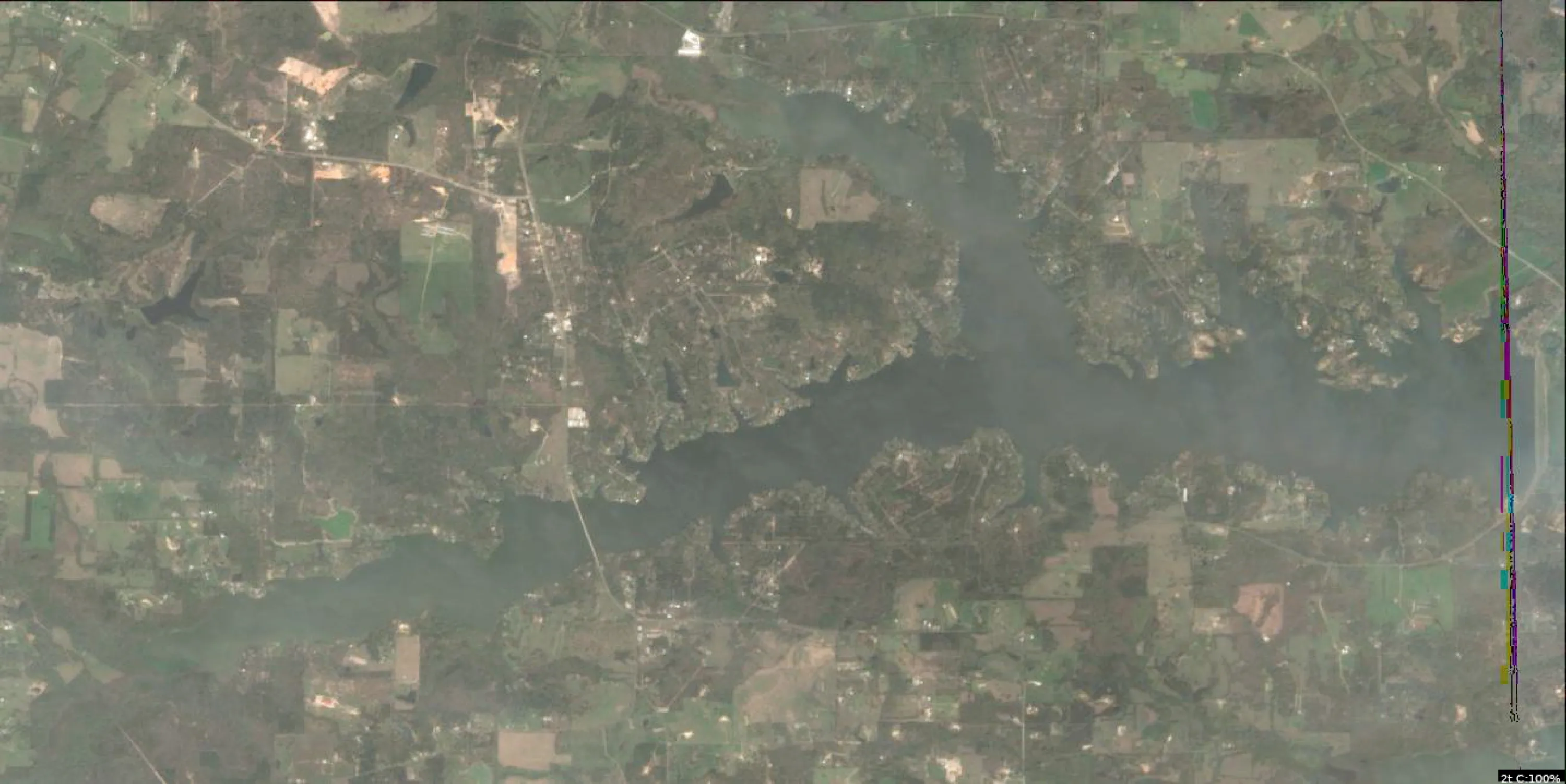
Lake Cypress Springs Satellite Analysis (Feb 26, 2026)
1. LAKE OVERVIEW (Natural Sections & Landmarks)
Lake Cypress Springs has an elongated north-south shape, roughly 8 miles long, with a narrow northern arm, a wider central main lake body, and a broader southern section that fans out. The lake divides naturally at a necked-down area in the central section where the shoreline pinches in, creating distinct upper (northern) and lower (southern) zones connected by this narrower channel.
Major Landmarks Visible:
- Northern boat ramp: Prominent ramp with parking lot on the northwest shore near the upper lake's widest point.
- Central marina: Cluster of docks and boats on the eastern shore of the main lake body, just south of the necked-down area.
- Southern boat ramp: Ramp with adjacent docks on the southwest shore of the lower lake.
- Bridge/road crossing: Visible road bridge spanning the narrow channel between northern arm and main lake.
- No large islands visible, but several small points extend into the main lake.
- Creek inflows: Dark linear inflows visible entering from the northeast shore (upper lake) and southeast shore (lower lake).
The lake shows color gradients from light tan shallows near shores to darker green open water, with sharp transitions at points and coves indicating drop-offs.
2. FINDABLE FISHING SPOTS
Here are 6 high-priority, findable spots based on visible structure (points, creek mouths) and cover (dock clusters, laydowns). Prioritized for pre-spawn bass staging (structure near shallows) and crappie (brushy docks). Ratings (1-10) factor visible complexity, cover, transitions, wind protection, and seasonal fit.
-
General Area: Northern arm
How to Find It: Launch at the northern boat ramp, head southeast along the west shore to the first major point with a cluster of 5-6 docks.
What You See: Point extending into darker water with dock cluster and sharp color change from tan shallows to medium green; linear laydowns from shore.
Why Fish It: Point with docks offers structure-cover combo for pre-spawn bass staging; protected from main lake wind (Priority 9/10).
Best Approach: Cast jigs or soft plastics along dock edges and color break for bass; minnows under docks for crappie. -
General Area: Main lake body (north side)
How to Find It: From the bridge crossing the necked-down channel, head east into the main lake to the big point on the north shore with scattered houses/docks.
What You See: Prominent point jutting south into open water, tan shallows transitioning sharply to dark green; 3-4 docks on the point.
Why Fish It: Classic transition point for bass moving from deep main lake to northern shallows; high structure score (Priority 8/10).
Best Approach: Fish the drop-off with crankbaits or drop-shot for schooling bass; watch for white bass boils. -
General Area: Main lake body (east shore)
How to Find It: Locate the central marina with multiple boat slips on the east shore, then go 1/4 mile north to the cove mouth with a line of docks.
What You See: Sheltered cove opening with dock row across the entrance; dark patch suggesting vegetation or brush inside; color shift at cove lip.
Why Fish It: Docks over transition provide cover for crappie and staging largemouth; wind-protected (Priority 9/10).
Best Approach: Shoot jigs under docks or troll spinners along cove edges. -
General Area: Southern section
How to Find It: Launch at the southern boat ramp, head northeast across the bay to the point with the longest dock row on the east shore.
What You See: Long point with 8+ docks in a row, extending into deeper green water; visible laydowns paralleling the shore.
Why Fish It: Dense dock cover on a point matches largemouth habitat; accessible depth transition (Priority 8/10).
Best Approach: Flip worms or jigs to dock pilings; drag bottom for catfish if bass inactive. -
General Area: Southern section (creek arm)
How to Find It: From the southern boat ramp, go east past the first cove to where the dark creek channel enters from the southeast shore.
What You See: Serpentine dark line (creek channel) swinging into the lake, flanked by points with docks; shallow tan flats nearby.
Why Fish It: Creek mouth staging for pre-spawn bass and catfish; channel provides migration route (Priority 7/10).
Best Approach: Work channel swings with lipless baits or drift cutbait for cats. -
General Area: Northern arm (inflow)
How to Find It: From northern boat ramp, head northeast up the arm to the creek mouth where the dark inflow meets the lake.
What You See: Narrow creek funneling into shallows, with a small point and dock cluster at the junction; color change along the point.
Why Fish It: Inflow point for baitfish and bass transition; compact structure (Priority 7/10).
Best Approach: Fan-cast swimbaits along the creek lip.
3. VISIBLE FEATURES BY LAKE SECTION
Northern Section/Arm: Narrow, creek-like upper end. Features: Northern boat ramp (NW shore); cluster of docks on SE-facing point (west shore); dark creek inflow on NE shore; scattered laydowns along east shore.
Main Lake Body: Widest central open water. Features: Bridge at north neck-down; central marina (east shore, boat clusters); big north shore point with docks; east shore cove with dock row; sharp color transitions at all points.
Southern Section: Broad lower basin. Features: Southern boat ramp (SW shore); long east shore dock row on point; SE creek channel inflow; multiple small coves with docks; tan shallows around bays.
Eastern/Western Arms: Minor extensions off main lake. East: Creek arm with channel visible. West: Narrow bay past southern ramp with dock clusters.
4. PRACTICAL FISHING GUIDANCE
Suggested Fishing Progression (Pre-spawn at 54°F: Start shallow staging, move to transitions midday):
- Start (Early AM): Northern arm - main point with docks off the boat ramp (protected shallows for warming bass).
- Mid-Morning: Main lake east shore cove near marina (as fish stage deeper).
- Pattern: Northern shallows early → main lake points midday → southern creek mouth late (follow sun/wind shifts).
Navigation Between Sections:
- Northern arm to main lake: Pass under/around the bridge at the necked-down channel.
- Main lake to southern section: Head south past the central marina, staying in deeper green water around points.
- Full loop: Northern ramp → bridge → marina → southern ramp → back north via west shore bays.
Focus on visible color breaks and docks—use electronics to confirm transitions on water. Wind today favors east shores for protection.
Findings:
-
Lake Cypress Springs Satellite Analysis (Feb 26, 2026)
1. LAKE OVERVIEW (Natural Sections & Landmarks)
Lake Cypress Springs has an elongated north-south shape, roughly 8 miles long, with a narrow northern arm, a wider central main lake body, and a broader southern section that fans out. The lake divides naturally at a necked-down area in the central section where the shoreline pinches in, creating distinct upper (northern) and lower (southern) zones connected by this narrower channel.
Major Landmarks Visible:
- Northern boat ramp: Prominent ramp with parking lot on the northwest shore near the upper lake's widest point.
- Central marina: Cluster of docks and boats on the eastern shore of the main lake body, just south of the necked-down area.
- Southern boat ramp: Ramp with adjacent docks on the southwest shore of the lower lake.
- Bridge/road crossing: Visible road bridge spanning the narrow channel between northern arm and main lake.
- No large islands visible, but several small points extend into the main lake.
- Creek inflows: Dark linear inflows visible entering from the northeast shore (upper lake) and southeast shore (lower lake).
The lake shows color gradients from light tan shallows near shores to darker green open water, with sharp transitions at points and coves indicating drop-offs.
2. FINDABLE FISHING SPOTS
Here are 6 high-priority, findable spots based on visible structure (points, creek mouths) and cover (dock clusters, laydowns). Prioritized for pre-spawn bass staging (structure near shallows) and crappie (brushy docks). Ratings (1-10) factor visible complexity, cover, transitions, wind protection, and seasonal fit.
-
General Area: Northern arm
How to Find It: Launch at the northern boat ramp, head southeast along the west shore to the first major point with a cluster of 5-6 docks.
What You See: Point extending into darker water with dock cluster and sharp color change from tan shallows to medium green; linear laydowns from shore.
Why Fish It: Point with docks offers structure-cover combo for pre-spawn bass staging; protected from main lake wind (Priority 9/10).
Best Approach: Cast jigs or soft plastics along dock edges and color break for bass; minnows under docks for crappie. -
General Area: Main lake body (north side)
How to Find It: From the bridge crossing the necked-down channel, head east into the main lake to the big point on the north shore with scattered houses/docks.
What You See: Prominent point jutting south into open water, tan shallows transitioning sharply to dark green; 3-4 docks on the point.
Why Fish It: Classic transition point for bass moving from deep main lake to northern shallows; high structure score (Priority 8/10).
Best Approach: Fish the drop-off with crankbaits or drop-shot for schooling bass; watch for white bass boils. -
General Area: Main lake body (east shore)
How to Find It: Locate the central marina with multiple boat slips on the east shore, then go 1/4 mile north to the cove mouth with a line of docks.
What You See: Sheltered cove opening with dock row across the entrance; dark patch suggesting vegetation or brush inside; color shift at cove lip.
Why Fish It: Docks over transition provide cover for crappie and staging largemouth; wind-protected (Priority 9/10).
Best Approach: Shoot jigs under docks or troll spinners along cove edges. -
General Area: Southern section
How to Find It: Launch at the southern boat ramp, head northeast across the bay to the point with the longest dock row on the east shore.
What You See: Long point with 8+ docks in a row, extending into deeper green water; visible laydowns paralleling the shore.
Why Fish It: Dense dock cover on a point matches largemouth habitat; accessible depth transition (Priority 8/10).
Best Approach: Flip worms or jigs to dock pilings; drag bottom for catfish if bass inactive. -
General Area: Southern section (creek arm)
How to Find It: From the southern boat ramp, go east past the first cove to where the dark creek channel enters from the southeast shore.
What You See: Serpentine dark line (creek channel) swinging into the lake, flanked by points with docks; shallow tan flats nearby.
Why Fish It: Creek mouth staging for pre-spawn bass and catfish; channel provides migration route (Priority 7/10).
Best Approach: Work channel swings with lipless baits or drift cutbait for cats. -
General Area: Northern arm (inflow)
How to Find It: From northern boat ramp, head northeast up the arm to the creek mouth where the dark inflow meets the lake.
What You See: Narrow creek funneling into shallows, with a small point and dock cluster at the junction; color change along the point.
Why Fish It: Inflow point for baitfish and bass transition; compact structure (Priority 7/10).
Best Approach: Fan-cast swimbaits along the creek lip.
3. VISIBLE FEATURES BY LAKE SECTION
Northern Section/Arm: Narrow, creek-like upper end. Features: Northern boat ramp (NW shore); cluster of docks on SE-facing point (west shore); dark creek inflow on NE shore; scattered laydowns along east shore.
Main Lake Body: Widest central open water. Features: Bridge at north neck-down; central marina (east shore, boat clusters); big north shore point with docks; east shore cove with dock row; sharp color transitions at all points.
Southern Section: Broad lower basin. Features: Southern boat ramp (SW shore); long east shore dock row on point; SE creek channel inflow; multiple small coves with docks; tan shallows around bays.
Eastern/Western Arms: Minor extensions off main lake. East: Creek arm with channel visible. West: Narrow bay past southern ramp with dock clusters.
4. PRACTICAL FISHING GUIDANCE
Suggested Fishing Progression (Pre-spawn at 54°F: Start shallow staging, move to transitions midday):
- Start (Early AM): Northern arm - main point with docks off the boat ramp (protected shallows for warming bass).
- Mid-Morning: Main lake east shore cove near marina (as fish stage deeper).
- Pattern: Northern shallows early → main lake points midday → southern creek mouth late (follow sun/wind shifts).
Navigation Between Sections:
- Northern arm to main lake: Pass under/around the bridge at the necked-down channel.
- Main lake to southern section: Head south past the central marina, staying in deeper green water around points.
- Full loop: Northern ramp → bridge → marina → southern ramp → back north via west shore bays.
Focus on visible color breaks and docks—use electronics to confirm transitions on water. Wind today favors east shores for protection.
How this was synthesized
Professional fishing guide analysis integrating 11 tools: analyze_weather_conditions, lure_matrix_wind_clarity, analyze_pressure_trends, estimate_seasonal_phase, get_community_reports, analyze_solunar_timing, analyze_hourly_conditions, analyze_species_behavior, analyze_water_clarity, analyze_thermal_patterns, analyze_satellite_imagery. User request: 'Generate a comprehensive fishing report for Lake Cypress Springs. Use tools to analyze satellite structure, thermal patterns, water clarity, weather, and solunar timing, then synthesize a concise plan.'. Synthesis generated comprehensive plan with professional recommendations.