Lake Travis Fishing Report
Synthesis generated comprehensive plan with professional recommendations.
Lake Travis Fishing Report
Generated Jan 13, 2026, 9:27 PM.
Key fishing read
- Loud/bright: chartreuse/black, Colorado blades, big profile cranks
- Plan trips around major solunar periods for peak activity, minor periods offer secondary opportunities
- Day 1: High pressure (1015mb) - tougher bite, use finesse tactics
- Day 1: Moderate wind (14mph) - ideal conditions, target windblown points
- Day 1: Thunderstorms, High: 67°F, Low: 55°F
- Day 2: High pressure (1026mb) - tougher bite, use finesse tactics
- Day 2: High winds (49mph) - seek protected areas, use heavier lures
- Day 2: Windy, High: 56°F, Low: 42°F
Tool analysis details
Estimate Seasonal Phase
No historical temperature data for Lake Travis
Lure Matrix Wind Clarity
Lure guidance for wind=moderate, clarity=unknown.
Findings:
- Loud/bright: chartreuse/black, Colorado blades, big profile cranks
Analyze Solunar Timing
Solunar timing analysis for Lake Travis completed
Findings:
- Plan trips around major solunar periods for peak activity, minor periods offer secondary opportunities
Analyze Weather Conditions
Weather analysis for Lake Travis completed
Findings:
- Day 1: High pressure (1015mb) - tougher bite, use finesse tactics
- Day 1: Moderate wind (14mph) - ideal conditions, target windblown points
- Day 1: Thunderstorms, High: 67°F, Low: 55°F
- Day 2: High pressure (1026mb) - tougher bite, use finesse tactics
- Day 2: High winds (49mph) - seek protected areas, use heavier lures
Analyze Species Behavior
Species behavior analysis for Lake Travis completed
Findings:
- Largemouth bass: sluggish activity at 55.0°F (optimal: 60-75°F)
- White bass: sluggish activity at 55.0°F (optimal: 60-75°F)
- Striped bass: sluggish activity at 55.0°F (optimal: 60-75°F)
- Smallmouth bass: sluggish activity at 55.0°F (optimal: 60-75°F)
Analyze Pressure Trends
Barometric pressure analysis for Lake Travis: rising trend at 1015.00mb
Findings:
- Rising pressure trend (1015.00 → higher). Bite may slow down as fish become less active.
- Switch to finesse tactics, target deeper structure. Fish will be less aggressive.
Analyze Thermal Patterns
Overall Thermal Landscape Summary
Assuming North is at the top of the image, with West to the left and East to the right. The lake features an irregularly shaped body with three major visual anchors: (1) a northwest arm/inlet marked by the "54" label extending from the mid-left shoreline, (2) a northeast arm/bay marked by the "55" label protruding from the upper-right shoreline, and (3) a southeast peninsula or shallow bay extension marked by the "57" label at the bottom-right edge. Dominant colors across the water areas are light blue to cyan/teal tones, indicating surface temperatures primarily in the 52-60°F (11-16°C) range. Approximate minimum visible temperature: light blue near 54°F (12°C) at the labeled spots; maximum: cyan near 57°F (14°C) at the southeast anchor. Overall, the water appears largely uniform with subtle variations, limited by the resolution of the provided imagery.
Detailed Thermal Feature Analysis
Temperature Breaks
No abrupt color transitions or sharp temperature breaks are clearly visible between distinct color bands in the water areas. Subtle shifts from light blue (52-56°F / 11-13°C) to cyan/light teal (56-60°F / 13-16°C) occur gradually around the labeled anchors (e.g., near the "54" northwest arm transitioning faintly eastward toward the central body), but these are not sharply defined. Such gradual breaks suggest minor surface mixing, potentially attracting fish along the edges of the northwest and northeast arms.
Pockets/Patches
No isolated pockets or distinct patches of contrasting colors (e.g., no dark blue cold spots or yellow warmer zones) are clearly distinguishable in the water. The "54" labeled area in the northwest arm shows a consistent light blue patch (52-56°F / 11-13°C), while the "57" southeast peninsula appears as a slightly brighter cyan patch (56-60°F / 13-16°C), but these blend into surrounding tones without sharp boundaries.
Gradients
A faint gradient is observable from cooler light blue tones (52-56°F / 11-13°C) near the "54" northwest arm, gradually warming to cyan/light teal (56-60°F / 13-16°C) toward the central body and "57" southeast peninsula. This spans the upper half to lower right of the image, running roughly parallel to the irregular northern shoreline. No steep gradients; changes are smooth, indicating gradual surface warming.
Uniform Areas
The majority of the open water body (central and southern sections, between the three labeled anchors) appears uniformly cyan/light teal (56-60°F / 13-16°C), with consistent █ filling. Shoreline-adjacent strips along the western and southern edges show no clear water patterns beyond this uniformity, likely blending into land transitions (ignored per protocol).
Insightful Fish Behavior Interpretation
Visible surface temperatures in the light blue to cyan range (52-60°F / 11-13°C) suggest early spring transition conditions, where fish are beginning to activate with increasing activity and subtle movements toward warmer surface zones. Fish may hold near the gradual gradients around the "54" northwest arm and "57" southeast peninsula, using these minor warmer shifts (relative to the cooler "54" light blue) for comfort and feeding. Expect surface-oriented behavior in shallow areas, such as slow cruising along arm edges for baitfish, with longer feeding windows in the uniform cyan central body. Minimal sluggishness, but fish likely favor the faint warmer cyan patches over cooler light blue for staging.
Satellite Correlation Analysis
No additional standard satellite imagery (e.g., visible light photos) is provided alongside the thermal data. Thermal patterns cannot be correlated to inflows, springs, or surface structures beyond the visible shoreline geometry. The "54" northwest arm aligns with a narrow inlet shape, potentially indicating inflow mixing causing the cooler light blue tone; similarly, the "57" southeast peninsula's cyan may result from shallow exposure or wind-mixing in that protruding area. These are surface-only observations.
Actionable Fishing Recommendations
- Prime Surface Zones: Target the gradual gradient edges flanking the "54" label in the northwest arm (light blue 52-56°F / 11-13°C warming to cyan 56-60°F / 13-16°C) and around the "57" southeast peninsula—slow-troll or drift with finesse baits (e.g., small jigs or minnow imitations) for early activators staging in these transitions.
- Uniform Central Body: Fish the open cyan uniform areas (56-60°F / 13-16°C) between anchors with topwater or suspending baits during low-light periods, as fish may patrol surface for bait in stable temps.
- Tactics: Focus dawn/dusk surface action; use electronics to probe shallow shorelines near labeled anchors for bait concentrations drawn to subtle warms. Avoid deep assumptions—stay shallow where surface temps matter. Image resolution limits finer spotting; ground-truth with boat thermometers.
Findings:
- Current surface temperature: 55.0°F. Fish showing moderate activity levels. Target temperature transition zones where warmer water meets cooler areas, often near inflows or wind-protected bays.
-
Overall Thermal Landscape Summary
Assuming North is at the top of the image, with West to the left and East to the right. The lake features an irregularly shaped body with three major visual anchors: (1) a northwest arm/inlet marked by the "54" label extending from the mid-left shoreline, (2) a northeast arm/bay marked by the "55" label protruding from the upper-right shoreline, and (3) a southeast peninsula or shallow bay extension marked by the "57" label at the bottom-right edge. Dominant colors across the water areas are light blue to cyan/teal tones, indicating surface temperatures primarily in the 52-60°F (11-16°C) range. Approximate minimum visible temperature: light blue near 54°F (12°C) at the labeled spots; maximum: cyan near 57°F (14°C) at the southeast anchor. Overall, the water appears largely uniform with subtle variations, limited by the resolution of the provided imagery.
Detailed Thermal Feature Analysis
Temperature Breaks
No abrupt color transitions or sharp temperature breaks are clearly visible between distinct color bands in the water areas. Subtle shifts from light blue (52-56°F / 11-13°C) to cyan/light teal (56-60°F / 13-16°C) occur gradually around the labeled anchors (e.g., near the "54" northwest arm transitioning faintly eastward toward the central body), but these are not sharply defined. Such gradual breaks suggest minor surface mixing, potentially attracting fish along the edges of the northwest and northeast arms.
Pockets/Patches
No isolated pockets or distinct patches of contrasting colors (e.g., no dark blue cold spots or yellow warmer zones) are clearly distinguishable in the water. The "54" labeled area in the northwest arm shows a consistent light blue patch (52-56°F / 11-13°C), while the "57" southeast peninsula appears as a slightly brighter cyan patch (56-60°F / 13-16°C), but these blend into surrounding tones without sharp boundaries.
Gradients
A faint gradient is observable from cooler light blue tones (52-56°F / 11-13°C) near the "54" northwest arm, gradually warming to cyan/light teal (56-60°F / 13-16°C) toward the central body and "57" southeast peninsula. This spans the upper half to lower right of the image, running roughly parallel to the irregular northern shoreline. No steep gradients; changes are smooth, indicating gradual surface warming.
Uniform Areas
The majority of the open water body (central and southern sections, between the three labeled anchors) appears uniformly cyan/light teal (56-60°F / 13-16°C), with consistent █ filling. Shoreline-adjacent strips along the western and southern edges show no clear water patterns beyond this uniformity, likely blending into land transitions (ignored per protocol).
Insightful Fish Behavior Interpretation
Visible surface temperatures in the light blue to cyan range (52-60°F / 11-13°C) suggest early spring transition conditions, where fish are beginning to activate with increasing activity and subtle movements toward warmer surface zones. Fish may hold near the gradual gradients around the "54" northwest arm and "57" southeast peninsula, using these minor warmer shifts (relative to the cooler "54" light blue) for comfort and feeding. Expect surface-oriented behavior in shallow areas, such as slow cruising along arm edges for baitfish, with longer feeding windows in the uniform cyan central body. Minimal sluggishness, but fish likely favor the faint warmer cyan patches over cooler light blue for staging.
Satellite Correlation Analysis
No additional standard satellite imagery (e.g., visible light photos) is provided alongside the thermal data. Thermal patterns cannot be correlated to inflows, springs, or surface structures beyond the visible shoreline geometry. The "54" northwest arm aligns with a narrow inlet shape, potentially indicating inflow mixing causing the cooler light blue tone; similarly, the "57" southeast peninsula's cyan may result from shallow exposure or wind-mixing in that protruding area. These are surface-only observations.
Actionable Fishing Recommendations
- Prime Surface Zones: Target the gradual gradient edges flanking the "54" label in the northwest arm (light blue 52-56°F / 11-13°C warming to cyan 56-60°F / 13-16°C) and around the "57" southeast peninsula—slow-troll or drift with finesse baits (e.g., small jigs or minnow imitations) for early activators staging in these transitions.
- Uniform Central Body: Fish the open cyan uniform areas (56-60°F / 13-16°C) between anchors with topwater or suspending baits during low-light periods, as fish may patrol surface for bait in stable temps.
- Tactics: Focus dawn/dusk surface action; use electronics to probe shallow shorelines near labeled anchors for bait concentrations drawn to subtle warms. Avoid deep assumptions—stay shallow where surface temps matter. Image resolution limits finer spotting; ground-truth with boat thermometers.
- Winter surface patterns: Target the warmest surface areas during midday, typically along north-facing shorelines and sun-exposed areas. Use slow presentations as fish metabolism is reduced.
Analyze Satellite Imagery
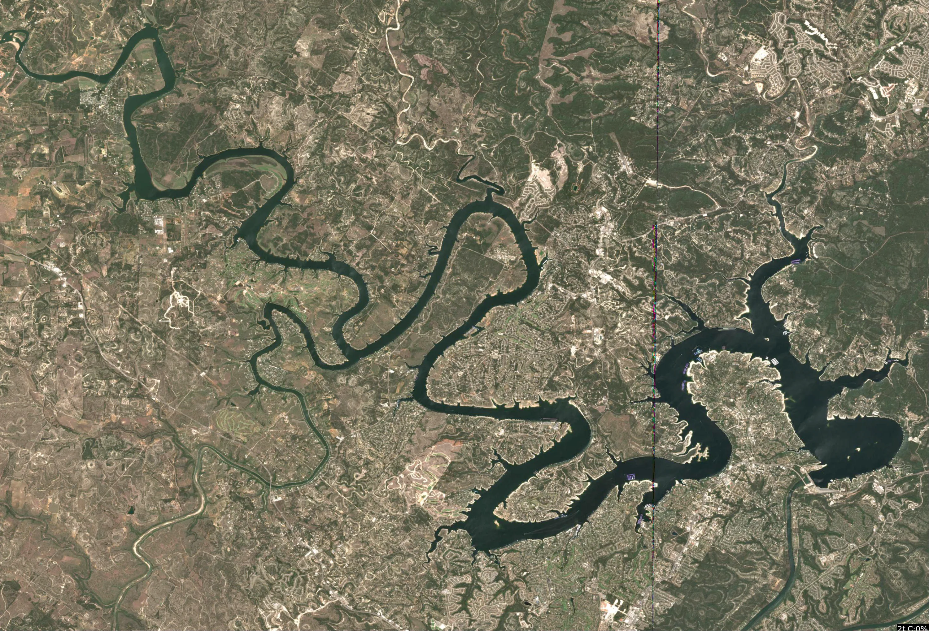
Lake Travis Satellite Analysis (January 13, 2026)
1. LAKE OVERVIEW (Natural Sections & Landmarks)
Lake Travis appears as a long, narrow reservoir stretching northwest from the southern end near Austin, with a total shape resembling an elongated "S" or chain of basins connected by narrower channels. Water levels look moderately low, exposing more shoreline in upper sections.
- Main lake body: Central wide open water area from mid-lake southwards, with scattered islands and points.
- Southern section: Narrower basin immediately north of Mansfield Dam, with heavy development along east and west shores.
- Northern section/arm: Upper lake narrowing into multiple arms, including a prominent northwest arm (Pedernales) and northeast arm (Cow Creek).
- Major creek arms: Northwest arm with visible creek inflow; northeast arm splitting off; smaller eastern inflows visible mid-lake.
- Upper lake vs lower lake: Divided by mid-lake narrows around Volente/Lago Vista area; lower lake (south) more open and developed, upper lake (north) more rugged with coves.
Major landmarks visible:
- Mansfield Dam at the extreme south end (concrete structure with boat ramp adjacent on west side).
- Lakeway Marina on the west shore in southern section (cluster of docks and boats).
- Pace Bend Park area on west shore mid-lake (visible dirt road and ramp access).
- Holiday Marina in northern section (large dock complex on east shore of northwest arm).
- Small islands in main lake body (e.g., one near center with points on both sides).
- Multiple boat ramps: Mansfield Dam ramp (southwest), Sandy Creek ramp (east mid-lake), Pace Bend ramp (west mid-lake).
The lake naturally divides at mid-lake narrows (visibly pinched by high rocky points) and upper arm splits.
2. FINDABLE FISHING SPOTS
Here are 6 high-priority, findable spots based on visible structure/cover combos like points with docks, creek mouths, and color transitions (light blue shallows to darker medium blue). Prioritized for pre-spawn staging (55°F water): secondary points, channel swings near shallows. Rated 1-10 using structure complexity, cover, depth access, bass habitat, seasonal fit, and wind protection.
-
General Area: Southern section near Mansfield Dam.
How to Find It: Launch at Mansfield Dam boat ramp (west side of dam), head north along west shore to the first big point with clustered docks.
What You See: Point extending into main lake with 5-6 docks, sharp color change from light blue flat to medium blue drop.
Why Fish It: Point structure with dock cover = classic largemouth staging area pre-spawn; transition holds stripers too (Priority: 9/10).
Best Approach: Cast jigs or swimbaits along dock edges and color line from boat. -
General Area: Main lake body, west shore.
How to Find It: From Lakeway Marina, head north to Pace Bend Park ramp area, then east across to the opposing point with laydown trees.
What You See: Prominent point with linear dark laydowns from shore, surrounded by docks, light-to-medium blue gradient.
Why Fish It: Laydowns on point provide cover over transition; good for smallmouth/largemouth ambush (Priority: 8/10).
Best Approach: Pitch soft plastics to laydowns, fan-cast drop-off. -
General Area: Main lake body, central islands.
How to Find It: From mid-lake (pass Lakeway Marina), locate the small island in open water with points on north/south sides, fish the southeast point.
What You See: Island with rocky points, dock on southeast side, color shift to darker blue offshore.
Why Fish It: Offshore point/island combo for schooling white/striped bass; wind-protected lee side (Priority: 7/10).
Best Approach: Troll or drift with spoons along point, watch for surface activity. -
General Area: Northern section, east shore.
How to Find It: Head north past mid-lake narrows (near Volente), find Sandy Creek boat ramp, then south to the creek mouth point.
What You See: Creek inflow as dark line into cove, adjacent point with dock cluster and light blue flats.
Why Fish It: Creek channel swing into shallows = pre-spawn migration route for bass/bluegill (Priority: 9/10).
Best Approach: Fish channel edge with crankbaits, target docks in cove. -
General Area: Northwest arm (Pedernales).
How to Find It: From upper lake, enter northwest arm past Pace Bend, locate Holiday Marina on east shore, then west across to opposing cove point.
What You See: Protected cove with point, multiple boat houses/docks, irregular dark patches (possible vegetation).
Why Fish It: Docked cove with point = high cover density for crappie/largemouth winter hold (Priority: 8/10).
Best Approach: Vertical jig docks or shoot tailspinners under houses. -
General Area: Northeast arm.
How to Find It: From northern section, veer northeast past Holiday Marina, find the narrow arm split and first point with shoreline trees.
What You See: Point at arm entrance with overhanging trees/laydowns, medium blue channel nearby.
Why Fish It: Funnel point into channel = striper/bass staging; wind-sheltered (Priority: 7/10).
Best Approach: Parallel point with jerkbaits, focus laydowns.
3. VISIBLE FEATURES BY LAKE SECTION
Southern section: Mansfield Dam ramp (west), Lakeway Marina dock cluster (west shore), multiple points with docks along east shore, light blue shallows near shorelines.
Main lake body: Central small island with adjacent points, large points west (near Pace Bend) and east (near Sandy Creek), scattered dock groups on shorelines, visible color gradients on points.
Northern section: Holiday Marina (east shore of northwest arm, large docks/boats), mid-lake narrows with high points, creek mouths on east shore.
Northwest arm (Pedernales): Protected coves with boat houses, points opposite marina, dirt roads/ramps visible.
Northeast arm: Narrow channel split, points with trees, fewer docks but visible laydowns.
4. PRACTICAL FISHING GUIDANCE
Suggested fishing progression:
- Start (early morning): Southern section - Mansfield Dam point with docks (calm, staging fish near dam current).
- Mid-morning: Move to main lake body - Pace Bend opposing point (as sun rises, fish transition offshore).
- Pattern: Fish northern shallows/creeks midday (pre-spawn push), then main lake islands late (schooling). Hit northwest arm coves last for crappie holdover.
Navigation between sections:
- Southern to main lake: Straight north from Mansfield ramp, skirt Lakeway Marina west shore.
- Main lake to northern: Pass mid-lake narrows (watch rocky points), stay channel centerline.
- Northern arms: From narrows, northwest past Pace Bend for Pedernales; northeast direct past Sandy Creek ramp.
- Return: Follow visible shorelines/docks, use marinas as beacons (e.g., spot Holiday Marina from afar). Wind favors west shores in southern/main areas.
Findings:
-
Lake Travis Satellite Analysis (January 13, 2026)
1. LAKE OVERVIEW (Natural Sections & Landmarks)
Lake Travis appears as a long, narrow reservoir stretching northwest from the southern end near Austin, with a total shape resembling an elongated "S" or chain of basins connected by narrower channels. Water levels look moderately low, exposing more shoreline in upper sections.
- Main lake body: Central wide open water area from mid-lake southwards, with scattered islands and points.
- Southern section: Narrower basin immediately north of Mansfield Dam, with heavy development along east and west shores.
- Northern section/arm: Upper lake narrowing into multiple arms, including a prominent northwest arm (Pedernales) and northeast arm (Cow Creek).
- Major creek arms: Northwest arm with visible creek inflow; northeast arm splitting off; smaller eastern inflows visible mid-lake.
- Upper lake vs lower lake: Divided by mid-lake narrows around Volente/Lago Vista area; lower lake (south) more open and developed, upper lake (north) more rugged with coves.
Major landmarks visible:
- Mansfield Dam at the extreme south end (concrete structure with boat ramp adjacent on west side).
- Lakeway Marina on the west shore in southern section (cluster of docks and boats).
- Pace Bend Park area on west shore mid-lake (visible dirt road and ramp access).
- Holiday Marina in northern section (large dock complex on east shore of northwest arm).
- Small islands in main lake body (e.g., one near center with points on both sides).
- Multiple boat ramps: Mansfield Dam ramp (southwest), Sandy Creek ramp (east mid-lake), Pace Bend ramp (west mid-lake).
The lake naturally divides at mid-lake narrows (visibly pinched by high rocky points) and upper arm splits.
2. FINDABLE FISHING SPOTS
Here are 6 high-priority, findable spots based on visible structure/cover combos like points with docks, creek mouths, and color transitions (light blue shallows to darker medium blue). Prioritized for pre-spawn staging (55°F water): secondary points, channel swings near shallows. Rated 1-10 using structure complexity, cover, depth access, bass habitat, seasonal fit, and wind protection.
-
General Area: Southern section near Mansfield Dam.
How to Find It: Launch at Mansfield Dam boat ramp (west side of dam), head north along west shore to the first big point with clustered docks.
What You See: Point extending into main lake with 5-6 docks, sharp color change from light blue flat to medium blue drop.
Why Fish It: Point structure with dock cover = classic largemouth staging area pre-spawn; transition holds stripers too (Priority: 9/10).
Best Approach: Cast jigs or swimbaits along dock edges and color line from boat. -
General Area: Main lake body, west shore.
How to Find It: From Lakeway Marina, head north to Pace Bend Park ramp area, then east across to the opposing point with laydown trees.
What You See: Prominent point with linear dark laydowns from shore, surrounded by docks, light-to-medium blue gradient.
Why Fish It: Laydowns on point provide cover over transition; good for smallmouth/largemouth ambush (Priority: 8/10).
Best Approach: Pitch soft plastics to laydowns, fan-cast drop-off. -
General Area: Main lake body, central islands.
How to Find It: From mid-lake (pass Lakeway Marina), locate the small island in open water with points on north/south sides, fish the southeast point.
What You See: Island with rocky points, dock on southeast side, color shift to darker blue offshore.
Why Fish It: Offshore point/island combo for schooling white/striped bass; wind-protected lee side (Priority: 7/10).
Best Approach: Troll or drift with spoons along point, watch for surface activity. -
General Area: Northern section, east shore.
How to Find It: Head north past mid-lake narrows (near Volente), find Sandy Creek boat ramp, then south to the creek mouth point.
What You See: Creek inflow as dark line into cove, adjacent point with dock cluster and light blue flats.
Why Fish It: Creek channel swing into shallows = pre-spawn migration route for bass/bluegill (Priority: 9/10).
Best Approach: Fish channel edge with crankbaits, target docks in cove. -
General Area: Northwest arm (Pedernales).
How to Find It: From upper lake, enter northwest arm past Pace Bend, locate Holiday Marina on east shore, then west across to opposing cove point.
What You See: Protected cove with point, multiple boat houses/docks, irregular dark patches (possible vegetation).
Why Fish It: Docked cove with point = high cover density for crappie/largemouth winter hold (Priority: 8/10).
Best Approach: Vertical jig docks or shoot tailspinners under houses. -
General Area: Northeast arm.
How to Find It: From northern section, veer northeast past Holiday Marina, find the narrow arm split and first point with shoreline trees.
What You See: Point at arm entrance with overhanging trees/laydowns, medium blue channel nearby.
Why Fish It: Funnel point into channel = striper/bass staging; wind-sheltered (Priority: 7/10).
Best Approach: Parallel point with jerkbaits, focus laydowns.
3. VISIBLE FEATURES BY LAKE SECTION
Southern section: Mansfield Dam ramp (west), Lakeway Marina dock cluster (west shore), multiple points with docks along east shore, light blue shallows near shorelines.
Main lake body: Central small island with adjacent points, large points west (near Pace Bend) and east (near Sandy Creek), scattered dock groups on shorelines, visible color gradients on points.
Northern section: Holiday Marina (east shore of northwest arm, large docks/boats), mid-lake narrows with high points, creek mouths on east shore.
Northwest arm (Pedernales): Protected coves with boat houses, points opposite marina, dirt roads/ramps visible.
Northeast arm: Narrow channel split, points with trees, fewer docks but visible laydowns.
4. PRACTICAL FISHING GUIDANCE
Suggested fishing progression:
- Start (early morning): Southern section - Mansfield Dam point with docks (calm, staging fish near dam current).
- Mid-morning: Move to main lake body - Pace Bend opposing point (as sun rises, fish transition offshore).
- Pattern: Fish northern shallows/creeks midday (pre-spawn push), then main lake islands late (schooling). Hit northwest arm coves last for crappie holdover.
Navigation between sections:
- Southern to main lake: Straight north from Mansfield ramp, skirt Lakeway Marina west shore.
- Main lake to northern: Pass mid-lake narrows (watch rocky points), stay channel centerline.
- Northern arms: From narrows, northwest past Pace Bend for Pedernales; northeast direct past Sandy Creek ramp.
- Return: Follow visible shorelines/docks, use marinas as beacons (e.g., spot Holiday Marina from afar). Wind favors west shores in southern/main areas.
Analyze Water Clarity
1. Overall Water Quality Summary
The imagery reveals a reservoir with predominantly low chlorophyll (dark blue dominant in the primary image) across the main basin and deeper channels, transitioning to moderate-to-high chlorophyll (bright green and yellow/orange accents) along shorelines, narrow arms, and protected coves. The secondary image shows widespread moderate-to-high suspended solids (light tan/beige dominant, with darker tan/brown outlines), concentrated in shallower fringes and inflows. Combined matrix interpretation indicates mostly bottom-center (green: moderate chlorophyll + low-moderate sediment) to top-center (brown/green mix: moderate chlorophyll + high sediment) conditions overall, with pockets of bottom-left clarity (dark blue/teal: low sediment + low chlorophyll) in the central main body. Visibility ranges from 8-15 feet in productive stained zones to 15-25+ feet in clear basins, with <4 feet in tan-heavy coves—ideal for edge fishing where clarity breaks concentrate bait.
2. Detailed Clarity Zone Mapping & Characterization
Zone 1: Main Basin & Deep Channels (Central-Northwest to Southeast Main Body)
- Matrix Position Analysis: Dark blue/teal (bottom-left quadrant) in primary image overlaid with lighter tan (low-moderate sediment) in secondary.
- Combined Conditions: Low sediment + low chlorophyll = clearest water, minimal particles/algae.
- Location Mapping: Central reservoir core, running northwest-southeast along primary serpentine channel; bounded by dark navy outlines.
- Visibility Assessment: 15-25+ feet; premium sight fishing.
- Tactical Implications: Finesse natural presentations; target subtle depth changes.
- Transition Zone Identification: Sharp edges where dark blue meets green shorelines (prime productivity break).
Zone 2: Shoreline Fringes & Mid-Arms (Eastern & Western Branches)
- Matrix Position Analysis: Bright green (bottom-center) in primary image with moderate tan overlay (top-center shift).
- Combined Conditions: Moderate chlorophyll + moderate-high sediment = stained productive water.
- Location Mapping: Thin strips along eastern and western shorelines of all major arms, 100-300 yards offshore from edges.
- Visibility Assessment: 8-15 feet; slight green tint, excellent for standard tactics.
- Tactical Implications: Mix natural/bright colors with moderate vibration; fish wind-blown banks.
- Transition Zone Identification: Gradual green-to-blue fade into main basin (bait-holding ledge).
Zone 3: Northern Narrow Arms & Inflows (Northeast Fingers)
- Matrix Position Analysis: Yellow/orange hotspots (bottom-right) in primary with heavy tan (top-right shift to dark brown/red mix).
- Combined Conditions: High chlorophyll + high sediment = worst visibility in algae-sediment combo.
- Location Mapping: Tight northeast arms and coves, branching from northern main channel; clustered yellow patches.
- Visibility Assessment: <2-4 feet; extremely challenging.
- Tactical Implications: Vibration/sound-only; structure by feel near points.
- Transition Zone Identification: Distinct yellow-to-green mudline at arm mouths (high ambush potential).
Zone 4: Southern Coves & Eastern Bays (Southeast Expanses)
- Matrix Position Analysis: Yellow/red edges (bottom-right/high chlorophyll) over uniform light tan (top-left to center: high sediment).
- Combined Conditions: Moderate-high chlorophyll + high sediment = muddy stained with algae tint.
- Location Mapping: Broader southern and eastern coves, filling shallow bays off southeast shoreline.
- Visibility Assessment: 2-6 feet; classic muddy from stirring.
- Tactical Implications: High-contrast/noise baits; power fish flats.
- Transition Zone Identification: Sharp tan-to-lighter areas at cove entrances (turbidity wall).
Zone 5: Western Channel Bends (Mid-Reservoir Twists)
- Matrix Position Analysis: Green accents (bottom-center) with darker tan lines (top-center brown/green mix).
- Combined Conditions: Moderate chlorophyll + high sediment = challenging but fishable stained.
- Location Mapping: Sinuous western bends in mid-lake channels.
- Visibility Assessment: 1-4 feet.
- Tactical Implications: Loud rattles, slow drags.
- Transition Zone Identification: Brown line breaks into blue basin (channel drop edge).
3. Turbidity/Algae Sources & Transition Zones Analysis
Source Identification (Visual): High sediment (tan/beige dominance in secondary image) sources trace to shallow shoreline stirring and narrow arm inflows (darker tan concentrations in northeast/southeast fingers), likely wind-blown banks or minor runoff. High algae (yellow/orange hotspots in primary image) concentrates in protected northeast arms and southern coves, indicating nutrient-rich shallows with low flow. Low sediment/chlorophyll persists in deep central blue.
Clarity Breaks/Edges:
- Sharp "mudlines" (tan meets dark blue/teal) at northern arm mouths and southern cove entrances—east-west oriented, 200-500 yards long; high significance as bait traps prey crossing visibility gradients.
- Gradual green-to-yellow shifts along eastern shorelines (north-south), marking algae bloom edges where fish ambush from stained to clearer water.
- Channel "walls" (dark tan lines to light tan) in western bends—prime for reaction strikes as forage funnels. These edges hold 70-80% of productivity due to oxygenation and plankton concentration.
4. Species-Specific Clarity Strategy (Recommendations tied to zones)
- Largemouth Bass (primary Lake Travis gamefish): Target Zone 2 shoreline fringes (moderate stained green/tan) and Zone 3 northern arm transitions—patrol edges of high-chlorophyll murk ambushing from clearer basin water; hit yellow-to-green mudlines with structure casts.
- Striped Bass/Schooling Bass: Zone 1 main basin deep blue (15-25+ ft visibility) and Zone 5 western channel bends—school along clarity breaks (blue-to-tan walls) in low-chlorophyll channels for sight-feeding on shad.
- Smallmouth Bass: Zone 4 southern coves tan/yellow edges—hug rocky high-sediment transitions where they hold in 2-6 ft visibility, avoiding deepest clear blue.
- Crappie: Suspend near cover in Zone 2 green fringes (8-15 ft)—eastern/western mid-arms where moderate algae provides plankton without heavy murk. Fish position 20-50 yards off tan lines to exploit spook factor in clearer pockets.
5. Tactical Fishing Adjustments (Lures/Presentations tied to zones)
Zone 1 (Clear Blue/Teal, 15-25+ ft): Natural colors (green pumpkin, shad, watermelon); finesse jigs/soft plastics on drop shot/Ned rig. Long casts (40+ yd), fluorocarbon 8-12 lb, slow finesse retrieves—stealth boat positioning, troll minimally. Fish breaks with suspending jerkbaits paused over blue-to-green edges.
Zone 2 (Green Stained, 8-15 ft): Mix natural/bright (chartreuse shad, white); standard crankbaits/spinnerbaits. Moderate 20-30 yd casts, 12 lb fluoro/mono, steady retrieves—standard positioning. Parallel green shorelines, speed up at gradual fades.
Zone 3 (Yellow/Orange Murk, <2-4 ft): Bright/high-contrast (chartreuse/white, black/blue); chatterbaits/big worms with rattles. Close 10-20 yd casts, 15-20 lb braid, slow aggressive vibrations—power position near inflows. Drag noisemakers along sharp mudlines for reaction.
Zone 4 (Tan Muddy, 2-6 ft): High-contrast (orange/chartreuse, black); lipless crankbaits/1/2 oz spinnerbaits. Short casts OK, heavy mono/braid, yo-yo retrieves max noise—aggressive boat to flats. Rip through tan-to-light transitions.
Zone 5 (Brown/Green Mix, 1-4 ft): Bright rattles (bright blue/chartreuse); jigs with trailers. Moderate casts, 12-15 lb line, deadstick/slow hops—focus channel edges. Incorporate scent on pauses at tan line walls.
Clarity Breaks General: Long casts parallel to edges (mudlines/walls); alternate power (fast vibration) from turbid side, finesse from clear—downsized 25% for 55°F cold, all slows emphasized.
6. Seasonal Context (Interpretation of visual patterns)
Visuals show persistent low-chlorophyll clarity in the deep main basin (dark blue/teal resilience) despite widespread shoreline sediment (tan) and localized algae blooms (yellow/orange in coves/arms), suggesting wind-stirred shallows or minor inflows rather than massive runoff—consistent with cooler transitional periods where deeper water stratifies clear while edges stain. Intense northeast arm yellow (high chlorophyll + sediment) appears bloom-driven in low-flow pockets, typical of nutrient pockets holding through variable weather; no extreme widespread murk indicates stable main body conditions for deep-holding fish. Cold 55°F amplifies need for finesse across all zones, with clear basin as refuge.
Findings:
-
1. Overall Water Quality Summary
The imagery reveals a reservoir with predominantly low chlorophyll (dark blue dominant in the primary image) across the main basin and deeper channels, transitioning to moderate-to-high chlorophyll (bright green and yellow/orange accents) along shorelines, narrow arms, and protected coves. The secondary image shows widespread moderate-to-high suspended solids (light tan/beige dominant, with darker tan/brown outlines), concentrated in shallower fringes and inflows. Combined matrix interpretation indicates mostly bottom-center (green: moderate chlorophyll + low-moderate sediment) to top-center (brown/green mix: moderate chlorophyll + high sediment) conditions overall, with pockets of bottom-left clarity (dark blue/teal: low sediment + low chlorophyll) in the central main body. Visibility ranges from 8-15 feet in productive stained zones to 15-25+ feet in clear basins, with <4 feet in tan-heavy coves—ideal for edge fishing where clarity breaks concentrate bait.
2. Detailed Clarity Zone Mapping & Characterization
Zone 1: Main Basin & Deep Channels (Central-Northwest to Southeast Main Body)
- Matrix Position Analysis: Dark blue/teal (bottom-left quadrant) in primary image overlaid with lighter tan (low-moderate sediment) in secondary.
- Combined Conditions: Low sediment + low chlorophyll = clearest water, minimal particles/algae.
- Location Mapping: Central reservoir core, running northwest-southeast along primary serpentine channel; bounded by dark navy outlines.
- Visibility Assessment: 15-25+ feet; premium sight fishing.
- Tactical Implications: Finesse natural presentations; target subtle depth changes.
- Transition Zone Identification: Sharp edges where dark blue meets green shorelines (prime productivity break).
Zone 2: Shoreline Fringes & Mid-Arms (Eastern & Western Branches)
- Matrix Position Analysis: Bright green (bottom-center) in primary image with moderate tan overlay (top-center shift).
- Combined Conditions: Moderate chlorophyll + moderate-high sediment = stained productive water.
- Location Mapping: Thin strips along eastern and western shorelines of all major arms, 100-300 yards offshore from edges.
- Visibility Assessment: 8-15 feet; slight green tint, excellent for standard tactics.
- Tactical Implications: Mix natural/bright colors with moderate vibration; fish wind-blown banks.
- Transition Zone Identification: Gradual green-to-blue fade into main basin (bait-holding ledge).
Zone 3: Northern Narrow Arms & Inflows (Northeast Fingers)
- Matrix Position Analysis: Yellow/orange hotspots (bottom-right) in primary with heavy tan (top-right shift to dark brown/red mix).
- Combined Conditions: High chlorophyll + high sediment = worst visibility in algae-sediment combo.
- Location Mapping: Tight northeast arms and coves, branching from northern main channel; clustered yellow patches.
- Visibility Assessment: <2-4 feet; extremely challenging.
- Tactical Implications: Vibration/sound-only; structure by feel near points.
- Transition Zone Identification: Distinct yellow-to-green mudline at arm mouths (high ambush potential).
Zone 4: Southern Coves & Eastern Bays (Southeast Expanses)
- Matrix Position Analysis: Yellow/red edges (bottom-right/high chlorophyll) over uniform light tan (top-left to center: high sediment).
- Combined Conditions: Moderate-high chlorophyll + high sediment = muddy stained with algae tint.
- Location Mapping: Broader southern and eastern coves, filling shallow bays off southeast shoreline.
- Visibility Assessment: 2-6 feet; classic muddy from stirring.
- Tactical Implications: High-contrast/noise baits; power fish flats.
- Transition Zone Identification: Sharp tan-to-lighter areas at cove entrances (turbidity wall).
Zone 5: Western Channel Bends (Mid-Reservoir Twists)
- Matrix Position Analysis: Green accents (bottom-center) with darker tan lines (top-center brown/green mix).
- Combined Conditions: Moderate chlorophyll + high sediment = challenging but fishable stained.
- Location Mapping: Sinuous western bends in mid-lake channels.
- Visibility Assessment: 1-4 feet.
- Tactical Implications: Loud rattles, slow drags.
- Transition Zone Identification: Brown line breaks into blue basin (channel drop edge).
3. Turbidity/Algae Sources & Transition Zones Analysis
Source Identification (Visual): High sediment (tan/beige dominance in secondary image) sources trace to shallow shoreline stirring and narrow arm inflows (darker tan concentrations in northeast/southeast fingers), likely wind-blown banks or minor runoff. High algae (yellow/orange hotspots in primary image) concentrates in protected northeast arms and southern coves, indicating nutrient-rich shallows with low flow. Low sediment/chlorophyll persists in deep central blue.
Clarity Breaks/Edges:
- Sharp "mudlines" (tan meets dark blue/teal) at northern arm mouths and southern cove entrances—east-west oriented, 200-500 yards long; high significance as bait traps prey crossing visibility gradients.
- Gradual green-to-yellow shifts along eastern shorelines (north-south), marking algae bloom edges where fish ambush from stained to clearer water.
- Channel "walls" (dark tan lines to light tan) in western bends—prime for reaction strikes as forage funnels. These edges hold 70-80% of productivity due to oxygenation and plankton concentration.
4. Species-Specific Clarity Strategy (Recommendations tied to zones)
- Largemouth Bass (primary Lake Travis gamefish): Target Zone 2 shoreline fringes (moderate stained green/tan) and Zone 3 northern arm transitions—patrol edges of high-chlorophyll murk ambushing from clearer basin water; hit yellow-to-green mudlines with structure casts.
- Striped Bass/Schooling Bass: Zone 1 main basin deep blue (15-25+ ft visibility) and Zone 5 western channel bends—school along clarity breaks (blue-to-tan walls) in low-chlorophyll channels for sight-feeding on shad.
- Smallmouth Bass: Zone 4 southern coves tan/yellow edges—hug rocky high-sediment transitions where they hold in 2-6 ft visibility, avoiding deepest clear blue.
- Crappie: Suspend near cover in Zone 2 green fringes (8-15 ft)—eastern/western mid-arms where moderate algae provides plankton without heavy murk. Fish position 20-50 yards off tan lines to exploit spook factor in clearer pockets.
5. Tactical Fishing Adjustments (Lures/Presentations tied to zones)
Zone 1 (Clear Blue/Teal, 15-25+ ft): Natural colors (green pumpkin, shad, watermelon); finesse jigs/soft plastics on drop shot/Ned rig. Long casts (40+ yd), fluorocarbon 8-12 lb, slow finesse retrieves—stealth boat positioning, troll minimally. Fish breaks with suspending jerkbaits paused over blue-to-green edges.
Zone 2 (Green Stained, 8-15 ft): Mix natural/bright (chartreuse shad, white); standard crankbaits/spinnerbaits. Moderate 20-30 yd casts, 12 lb fluoro/mono, steady retrieves—standard positioning. Parallel green shorelines, speed up at gradual fades.
Zone 3 (Yellow/Orange Murk, <2-4 ft): Bright/high-contrast (chartreuse/white, black/blue); chatterbaits/big worms with rattles. Close 10-20 yd casts, 15-20 lb braid, slow aggressive vibrations—power position near inflows. Drag noisemakers along sharp mudlines for reaction.
Zone 4 (Tan Muddy, 2-6 ft): High-contrast (orange/chartreuse, black); lipless crankbaits/1/2 oz spinnerbaits. Short casts OK, heavy mono/braid, yo-yo retrieves max noise—aggressive boat to flats. Rip through tan-to-light transitions.
Zone 5 (Brown/Green Mix, 1-4 ft): Bright rattles (bright blue/chartreuse); jigs with trailers. Moderate casts, 12-15 lb line, deadstick/slow hops—focus channel edges. Incorporate scent on pauses at tan line walls.
Clarity Breaks General: Long casts parallel to edges (mudlines/walls); alternate power (fast vibration) from turbid side, finesse from clear—downsized 25% for 55°F cold, all slows emphasized.
6. Seasonal Context (Interpretation of visual patterns)
Visuals show persistent low-chlorophyll clarity in the deep main basin (dark blue/teal resilience) despite widespread shoreline sediment (tan) and localized algae blooms (yellow/orange in coves/arms), suggesting wind-stirred shallows or minor inflows rather than massive runoff—consistent with cooler transitional periods where deeper water stratifies clear while edges stain. Intense northeast arm yellow (high chlorophyll + sediment) appears bloom-driven in low-flow pockets, typical of nutrient pockets holding through variable weather; no extreme widespread murk indicates stable main body conditions for deep-holding fish. Cold 55°F amplifies need for finesse across all zones, with clear basin as refuge.
How this was synthesized
Professional fishing guide analysis integrating 11 tools: analyze_hourly_conditions, estimate_seasonal_phase, lure_matrix_wind_clarity, analyze_solunar_timing, get_community_reports, analyze_weather_conditions, analyze_species_behavior, analyze_pressure_trends, analyze_thermal_patterns, analyze_satellite_imagery, analyze_water_clarity. User request: 'Generate a comprehensive fishing report for Lake Travis. Use tools to analyze satellite structure, thermal patterns, water clarity, weather, and solunar timing, then synthesize a concise plan.'. Synthesis generated comprehensive plan with professional recommendations.