Seminoe Reservoir Fishing Report
Synthesis generated comprehensive plan with professional recommendations.
Seminoe Reservoir Fishing Report
Generated Jan 6, 2026, 7:35 PM.
Key fishing read
- Max thump: giant spinnerbaits, slow roll, contact cover
- Plan trips around major solunar periods for peak activity, minor periods offer secondary opportunities
- Day 1: High pressure (1016mb) - tougher bite, use finesse tactics
- Day 1: High winds (63mph) - seek protected areas, use heavier lures
- Day 1: Windy, High: 40°F, Low: 27°F
- Day 2: High pressure (1010mb) - tougher bite, use finesse tactics
- Day 2: High winds (53mph) - seek protected areas, use heavier lures
- Day 2: Windy, High: 38°F, Low: 28°F
Tool analysis details
Estimate Seasonal Phase
No historical temperature data for Seminoe Reservoir
Lure Matrix Wind Clarity
Lure guidance for wind=windy, clarity=unknown.
Findings:
- Max thump: giant spinnerbaits, slow roll, contact cover
Analyze Solunar Timing
Solunar timing analysis for Seminoe Reservoir completed
Findings:
- Plan trips around major solunar periods for peak activity, minor periods offer secondary opportunities
Analyze Weather Conditions
Weather analysis for Seminoe Reservoir completed
Findings:
- Day 1: High pressure (1016mb) - tougher bite, use finesse tactics
- Day 1: High winds (63mph) - seek protected areas, use heavier lures
- Day 1: Windy, High: 40°F, Low: 27°F
- Day 2: High pressure (1010mb) - tougher bite, use finesse tactics
- Day 2: High winds (53mph) - seek protected areas, use heavier lures
Analyze Species Behavior
Species behavior analysis for Seminoe Reservoir completed
Findings:
- Walleye: Cold water active (37.0°F), target deep edges with live bait or slow jigs
- Rainbow trout: sluggish activity at 37.0°F (optimal: 45-65°F)
- Brown trout: sluggish activity at 37.0°F (optimal: 45-65°F)
- Cutthroat trout: sluggish activity at 37.0°F (optimal: 45-65°F)
- Walleye: sluggish activity at 37.0°F (optimal: 45-65°F)
Analyze Pressure Trends
Barometric pressure analysis for Seminoe Reservoir: rising trend at 1016.00mb
Findings:
- Rising pressure trend (1016.00 → higher). Bite may slow down as fish become less active.
- Switch to finesse tactics, target deeper structure. Fish will be less aggressive.
Analyze Thermal Patterns
Overall Thermal Landscape Summary
Assuming North is at the top of the image, East to the right, West to the left, and South at the bottom (standard orientation for satellite imagery). The overall shape appears to be an irregularly shaped lake body with sparse, scattered pixel-like features amid mostly uniform empty space, suggesting low-resolution or heavily compressed data. No major visual anchors like distinct bays, peninsulas, islands, or inlets are clearly distinguishable due to the minimalistic text-based representation. Dominant "features" are three small, isolated clusters of characters labeled with numbers and degree symbols (33° near top-center-right, 34° mid-right, and 32°/33° at bottom-left). No colors are visible in the provided image, preventing direct mapping to the thermal color key. Approximate min/max temperatures cannot be precisely determined without colors, but numeric labels suggest surface water around 32-34°F (0-1°C), below the provided scale's minimum (40°F), indicating extremely cold conditions overall. Image quality is poor and ambiguous—analysis is severely limited to these sparse labels and dot patterns.
Detailed Thermal Feature Analysis
Temperature Breaks: No clearly visible color-based boundaries or abrupt transitions between thermal zones, as no colors are present. The sparse clusters (e.g., the 33° cluster separated from the 34° cluster by empty space) show isolation rather than connected breaks, with no evident sharpness or gradients.
Pockets/Patches: Three small, distinct patches are visible as character clusters:
- Top-center-right patch centered on "33°" surrounded by dots and accent marks (e.g., ` ´), suggesting a localized anomaly ~33°F (1°C).
- Mid-right patch at "34°" with adjacent dots, ~34°F (1°C).
- Bottom-left patch with "32°" and "33°" amid dots, ~32-33°F (0-1°C). These are tiny (few characters wide) and not analyzable for shape/orientation beyond isolation.
Gradients: No gradual or visible color transitions detectable; the image is predominantly uniform empty space with abrupt appearances of these clusters against the background.
Uniform Areas: The vast majority of the image (open water areas) shows uniform empty space or scattered single dots, implying consistent very cold surface temperatures below the scale (likely <40°F / <4°C), with no distinguishable warmer or cooler variations within water zones. Land-water boundaries are unclear due to lack of detail.
Insightful Fish Behavior Interpretation
With surface temperatures indicated around 32-34°F (0-1°C)—well below the scale's coldest category (very dark navy blue, 40-42°F / 4-6°C)—fish activity would be extremely sluggish across the lake. Expect minimal surface feeding, with fish in deep holding patterns or dormant states typical of deep winter/ice-over conditions. The isolated clusters may represent minor surface anomalies (e.g., slight upwellings or inflows), potentially attracting lethargic fish seeking any relative warmth, but overall uniformity suggests no active surface behavior. Focus on long, slow presentations near any structure if accessible, but surface-oriented fishing is unlikely viable.
Satellite Correlation Analysis
No additional satellite imagery (e.g., visible light or bathymetry) is provided alongside the thermal data. The sparse clusters could hypothetically align with inflows (e.g., the top-center-right 33° near potential northern inlet) or wind-mixed spots, but this cannot be confirmed without visible features. Shoreline geometry is indistinct, preventing correlation with points, coves, or springs. Observed patterns (isolated cold spots) likely result from surface cooling or minor freshwater inputs, but image resolution limits confident surface feature causation.
Actionable Fishing Recommendations
Due to poor image quality and lack of visible colors/patterns, recommendations are general and conservative—prioritize safety (possible ice) over surface fishing. Target the three isolated clusters as potential minor warm refuges:
- Probe near the top-center-right "33°" cluster (relative to assumed North top) with ultra-slow jigs or deadbait for staging fish.
- Check mid-right "34°" patch similarly, watching for any surface ripples.
- Bottom-left "32°/33°" area as a last resort, focusing on adjacent dots. Use electronics for depth confirmation; avoid open uniform areas. If ice fishing, drill near clusters. Re-scan with higher-res imagery for better intel—current data supports low expectations for surface activity.
Findings:
- Current surface temperature: 37.0°F. Fish metabolism significantly reduced in cold water. Target sunny, protected shorelines and use extremely slow presentations. Focus on midday when surface temperatures are warmest.
-
Overall Thermal Landscape Summary
Assuming North is at the top of the image, East to the right, West to the left, and South at the bottom (standard orientation for satellite imagery). The overall shape appears to be an irregularly shaped lake body with sparse, scattered pixel-like features amid mostly uniform empty space, suggesting low-resolution or heavily compressed data. No major visual anchors like distinct bays, peninsulas, islands, or inlets are clearly distinguishable due to the minimalistic text-based representation. Dominant "features" are three small, isolated clusters of characters labeled with numbers and degree symbols (33° near top-center-right, 34° mid-right, and 32°/33° at bottom-left). No colors are visible in the provided image, preventing direct mapping to the thermal color key. Approximate min/max temperatures cannot be precisely determined without colors, but numeric labels suggest surface water around 32-34°F (0-1°C), below the provided scale's minimum (40°F), indicating extremely cold conditions overall. Image quality is poor and ambiguous—analysis is severely limited to these sparse labels and dot patterns.
Detailed Thermal Feature Analysis
Temperature Breaks: No clearly visible color-based boundaries or abrupt transitions between thermal zones, as no colors are present. The sparse clusters (e.g., the 33° cluster separated from the 34° cluster by empty space) show isolation rather than connected breaks, with no evident sharpness or gradients.
Pockets/Patches: Three small, distinct patches are visible as character clusters:
- Top-center-right patch centered on "33°" surrounded by dots and accent marks (e.g., ` ´), suggesting a localized anomaly ~33°F (1°C).
- Mid-right patch at "34°" with adjacent dots, ~34°F (1°C).
- Bottom-left patch with "32°" and "33°" amid dots, ~32-33°F (0-1°C). These are tiny (few characters wide) and not analyzable for shape/orientation beyond isolation.
Gradients: No gradual or visible color transitions detectable; the image is predominantly uniform empty space with abrupt appearances of these clusters against the background.
Uniform Areas: The vast majority of the image (open water areas) shows uniform empty space or scattered single dots, implying consistent very cold surface temperatures below the scale (likely <40°F / <4°C), with no distinguishable warmer or cooler variations within water zones. Land-water boundaries are unclear due to lack of detail.
Insightful Fish Behavior Interpretation
With surface temperatures indicated around 32-34°F (0-1°C)—well below the scale's coldest category (very dark navy blue, 40-42°F / 4-6°C)—fish activity would be extremely sluggish across the lake. Expect minimal surface feeding, with fish in deep holding patterns or dormant states typical of deep winter/ice-over conditions. The isolated clusters may represent minor surface anomalies (e.g., slight upwellings or inflows), potentially attracting lethargic fish seeking any relative warmth, but overall uniformity suggests no active surface behavior. Focus on long, slow presentations near any structure if accessible, but surface-oriented fishing is unlikely viable.
Satellite Correlation Analysis
No additional satellite imagery (e.g., visible light or bathymetry) is provided alongside the thermal data. The sparse clusters could hypothetically align with inflows (e.g., the top-center-right 33° near potential northern inlet) or wind-mixed spots, but this cannot be confirmed without visible features. Shoreline geometry is indistinct, preventing correlation with points, coves, or springs. Observed patterns (isolated cold spots) likely result from surface cooling or minor freshwater inputs, but image resolution limits confident surface feature causation.
Actionable Fishing Recommendations
Due to poor image quality and lack of visible colors/patterns, recommendations are general and conservative—prioritize safety (possible ice) over surface fishing. Target the three isolated clusters as potential minor warm refuges:
- Probe near the top-center-right "33°" cluster (relative to assumed North top) with ultra-slow jigs or deadbait for staging fish.
- Check mid-right "34°" patch similarly, watching for any surface ripples.
- Bottom-left "32°/33°" area as a last resort, focusing on adjacent dots. Use electronics for depth confirmation; avoid open uniform areas. If ice fishing, drill near clusters. Re-scan with higher-res imagery for better intel—current data supports low expectations for surface activity.
- Winter surface patterns: Target the warmest surface areas during midday, typically along north-facing shorelines and sun-exposed areas. Use slow presentations as fish metabolism is reduced.
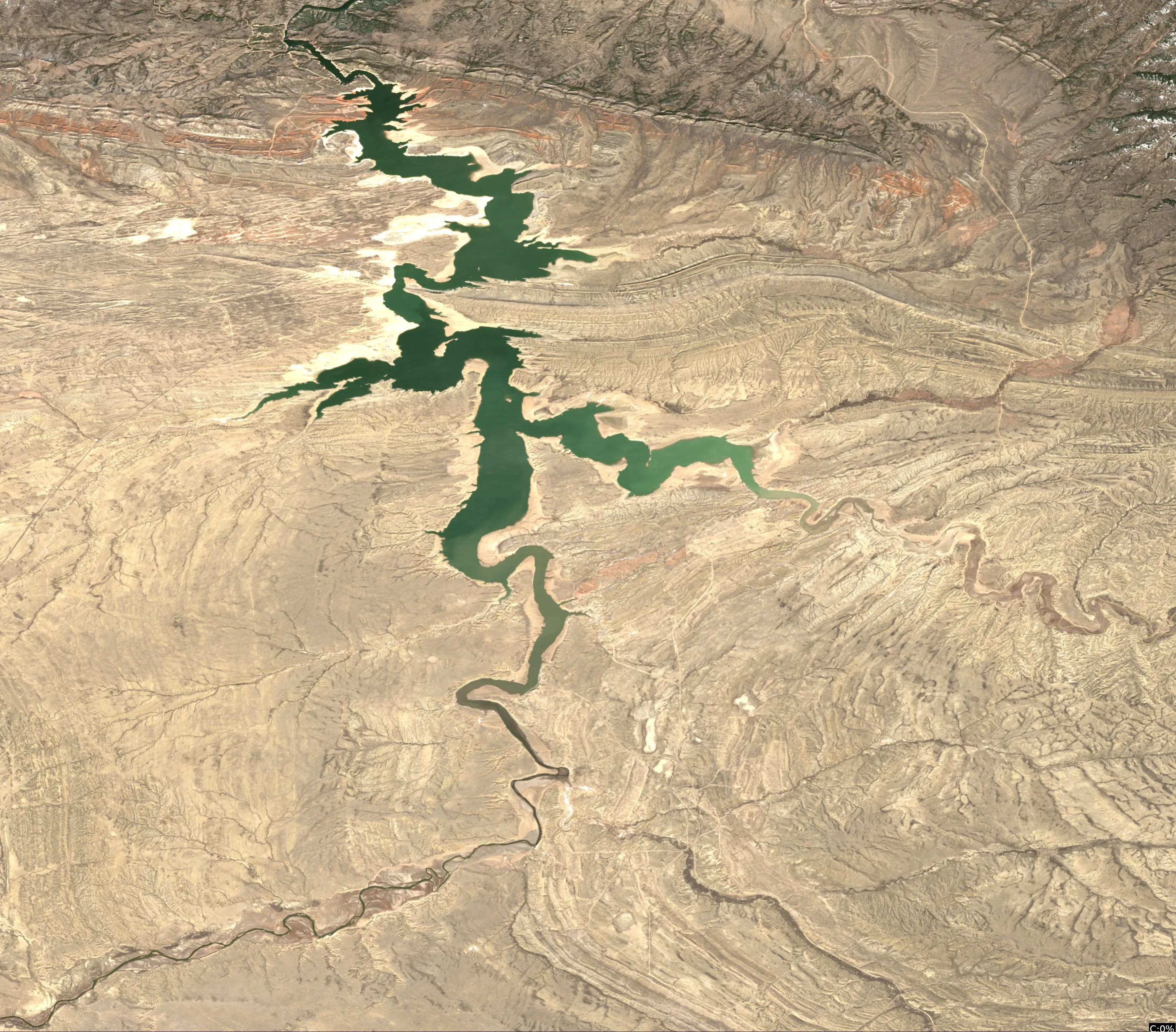
Analyze Satellite Imagery
Seminoe Reservoir Satellite Analysis (WY, Carbon County - Jan 6, 2026)
1. LAKE OVERVIEW (Natural Sections & Landmarks)
Seminoe Reservoir is a large, irregularly shaped body of water oriented roughly north-south, with a wide main lake body in the central area flanked by extended arms.
- Main lake body: Broad central open water (dark blue gradients indicating deeper areas), narrowing at points to the north and south.
- Northern section/arm: Narrower extension northward from the main body, with tan/light blue shallows along shores and darker channels visible snaking in.
- Southern section/arm: Tapered area south toward the dam, with steep tan shorelines transitioning to medium blue.
- Eastern arm: Distinct elongated bay extending east from the main body, with serpentine dark lines suggesting channels and multiple coves.
- Western arm: Shorter bay west off the main body, with clustered docks visible.
- Upper lake vs lower lake: Upper (northern) lake more fragmented with arms; lower (southern/main) lake wider and deeper-toned.
Major landmarks visible:
- Seminoe Dam: Prominent straight structure at the far southern tip, with light tan reservoir drawdown visible upstream.
- Boat ramp: Gravel launch area on the western shore mid-main body (near clustered docks).
- Marina/docks: Cluster of linear docks and boat houses on the northwest shore of the main body.
- Islands: Small island in the eastern arm (dark patch surrounded by lighter water).
- Creek mouths: Dark linear inflows visible at the north end of the northern section and southeast edge of the eastern arm.
- No bridges visible; lake divides naturally via narrow points and shallow tan bars.
2. FINDABLE FISHING SPOTS
Identified 6 high-priority spots based on visible color transitions (sharp light-to-dark blue drop-offs), points, channels, and cover. Prioritized for winter/pre-spawn (deep refuge near structure) and walleye/trout habitat (channel edges, points). Each rated 1-10 using structure/cover complexity, depth access, seasonal fit.
-
General Area: Main lake body - northwest shore near marina.
How to Find It: Launch from the visible boat ramp on west shore, head north 0.5 mile to the cluster of docks/marina.
What You See: Cluster of rectangular docks with paths, adjacent point extending east into medium-dark blue transition, tan shallows on inside.
Why Fish It (Priority: 9/10): Point with docks offers structure/cover combo; color shift suggests drop-off for winter thermal refuge; wind-protected cove suits walleye on edges.
Best Approach: Troll channel edge along point (dark line) or cast jigs to dock shadows from boat. -
General Area: Southern section - just north of the dam.
How to Find It: From main body, head south past wide points to the straight dam wall; fish the first major point upstream on east shore.
What You See: Prominent east-shore point with sharp tan-to-dark blue change, linear dark shadow possibly laydown from shore.
Why Fish It (Priority: 8/10): Steep bank drop-off (color transition) near deep basin; pre-spawn trout staging; dam current influence.
Best Approach: Anchor or drift point edge, vertical jig for deep water adjacent to shallows. -
General Area: Eastern arm - mid-arm near island.
How to Find It: From main body, enter eastern arm heading east, pass first cove to the small central island.
What You See: Small dark island with points on both sides, surrounding medium blue with dark serpentine channel leading south.
Why Fish It (Priority: 9/10): Island points with channel = high structure complexity; protected from wind; walleye reefs/edges visible as color bands.
Best Approach: Circle island trolling channel bends or cast to windward point flats. -
General Area: Northern section - creek mouth area.
How to Find It: From marina docks, head north into narrowing northern arm to where dark linear creek inflow meets the lake on west shore.
What You See: Dark serpentine line (creek channel) dumping into tan flat, flanked by darker blue on east side.
Why Fish It (Priority: 7/10): Creek channel transition to deep water; winter fish following inflow for staging near spawning flats.
Best Approach: Position in channel mouth, fan-cast edges or slow-troll inbound path. -
General Area: Main lake body - eastern shore point.
How to Find It: From boat ramp, cross main body east to the large protruding point before the eastern arm entrance.
What You See: Bold point jutting west into dark blue, with tan flat inside bay and dock nearby on north side.
Why Fish It (Priority: 8/10): Exposed point with quick depth change (light-to-dark gradient); wind-blown for walleye; adjacent cover.
Best Approach: Drift or troll point from shallow to deep side, focus color break. -
General Area: Western arm - back of bay.
How to Find It: From boat ramp, head west into short arm to the rearmost cove with clustered dark patches.
What You See: Protected cove with irregular dark clusters (possible brush/veggie) on tan bottom, medium blue drop to main lake.
Why Fish It (Priority: 6/10): Cover in transition zone; wind-sheltered winter holdover; secondary structure.
Best Approach: Anchor over dark patches, pitch to shore or fan-cast ledge line.
3. VISIBLE FEATURES BY LAKE SECTION
Northern section: Narrow arm with west-shore creek mouth (dark line), scattered single docks on east shore, tan shallows narrowing to dark channel.
Main lake body: Central dark blue expanse; northwest marina dock cluster; large east-shore point with color transition; boat ramp gravel on west mid-shore; subtle dark humps as light-surrounded patches south-central.
Southern section: Dam at south end; east-shore point with sharp tan-dark line; steep tan bluffs west shore; medium blue basin north of dam.
Eastern arm: Elongated with central small island; serpentine dark channels into coves; multiple points with blue gradients; creek-like inflow at SE end.
Western arm: Short bay with rear cove dark clusters; dock lines mid-bay; tan flats leading to medium blue drop.
4. PRACTICAL FISHING GUIDANCE
Suggested fishing progression (winter 37°F pattern: deep structure early, transitions midday):
- Start (dawn/early): Main lake body northwest near marina docks (priority 9) - sheltered deep edges for refuge trout/walleye.
- Mid-morning: Move south to dam point (priority 8) as sun warms shallows slightly.
- Pattern: Northern creek mouth early inflows, then eastern arm island midday for wind shifts; end on main lake points. Relate sections via main body crossings.
Navigation between sections:
- Northern to main: Straight south from creek mouth, pass marina.
- Main to eastern arm: East from big point, follow shorelines.
- Main to southern: South past ramp, skirt west bluffs to dam.
- Western arm: Short hop west from ramp into bay.
- All spots accessible in 10-20 min from ramp; hug shores for visible landmarks, watch color breaks for drop-offs. Safe in winter; check ice edges if present.
Findings:
-
Seminoe Reservoir Satellite Analysis (WY, Carbon County - Jan 6, 2026)
1. LAKE OVERVIEW (Natural Sections & Landmarks)
Seminoe Reservoir is a large, irregularly shaped body of water oriented roughly north-south, with a wide main lake body in the central area flanked by extended arms.
- Main lake body: Broad central open water (dark blue gradients indicating deeper areas), narrowing at points to the north and south.
- Northern section/arm: Narrower extension northward from the main body, with tan/light blue shallows along shores and darker channels visible snaking in.
- Southern section/arm: Tapered area south toward the dam, with steep tan shorelines transitioning to medium blue.
- Eastern arm: Distinct elongated bay extending east from the main body, with serpentine dark lines suggesting channels and multiple coves.
- Western arm: Shorter bay west off the main body, with clustered docks visible.
- Upper lake vs lower lake: Upper (northern) lake more fragmented with arms; lower (southern/main) lake wider and deeper-toned.
Major landmarks visible:
- Seminoe Dam: Prominent straight structure at the far southern tip, with light tan reservoir drawdown visible upstream.
- Boat ramp: Gravel launch area on the western shore mid-main body (near clustered docks).
- Marina/docks: Cluster of linear docks and boat houses on the northwest shore of the main body.
- Islands: Small island in the eastern arm (dark patch surrounded by lighter water).
- Creek mouths: Dark linear inflows visible at the north end of the northern section and southeast edge of the eastern arm.
- No bridges visible; lake divides naturally via narrow points and shallow tan bars.
2. FINDABLE FISHING SPOTS
Identified 6 high-priority spots based on visible color transitions (sharp light-to-dark blue drop-offs), points, channels, and cover. Prioritized for winter/pre-spawn (deep refuge near structure) and walleye/trout habitat (channel edges, points). Each rated 1-10 using structure/cover complexity, depth access, seasonal fit.
-
General Area: Main lake body - northwest shore near marina.
How to Find It: Launch from the visible boat ramp on west shore, head north 0.5 mile to the cluster of docks/marina.
What You See: Cluster of rectangular docks with paths, adjacent point extending east into medium-dark blue transition, tan shallows on inside.
Why Fish It (Priority: 9/10): Point with docks offers structure/cover combo; color shift suggests drop-off for winter thermal refuge; wind-protected cove suits walleye on edges.
Best Approach: Troll channel edge along point (dark line) or cast jigs to dock shadows from boat. -
General Area: Southern section - just north of the dam.
How to Find It: From main body, head south past wide points to the straight dam wall; fish the first major point upstream on east shore.
What You See: Prominent east-shore point with sharp tan-to-dark blue change, linear dark shadow possibly laydown from shore.
Why Fish It (Priority: 8/10): Steep bank drop-off (color transition) near deep basin; pre-spawn trout staging; dam current influence.
Best Approach: Anchor or drift point edge, vertical jig for deep water adjacent to shallows. -
General Area: Eastern arm - mid-arm near island.
How to Find It: From main body, enter eastern arm heading east, pass first cove to the small central island.
What You See: Small dark island with points on both sides, surrounding medium blue with dark serpentine channel leading south.
Why Fish It (Priority: 9/10): Island points with channel = high structure complexity; protected from wind; walleye reefs/edges visible as color bands.
Best Approach: Circle island trolling channel bends or cast to windward point flats. -
General Area: Northern section - creek mouth area.
How to Find It: From marina docks, head north into narrowing northern arm to where dark linear creek inflow meets the lake on west shore.
What You See: Dark serpentine line (creek channel) dumping into tan flat, flanked by darker blue on east side.
Why Fish It (Priority: 7/10): Creek channel transition to deep water; winter fish following inflow for staging near spawning flats.
Best Approach: Position in channel mouth, fan-cast edges or slow-troll inbound path. -
General Area: Main lake body - eastern shore point.
How to Find It: From boat ramp, cross main body east to the large protruding point before the eastern arm entrance.
What You See: Bold point jutting west into dark blue, with tan flat inside bay and dock nearby on north side.
Why Fish It (Priority: 8/10): Exposed point with quick depth change (light-to-dark gradient); wind-blown for walleye; adjacent cover.
Best Approach: Drift or troll point from shallow to deep side, focus color break. -
General Area: Western arm - back of bay.
How to Find It: From boat ramp, head west into short arm to the rearmost cove with clustered dark patches.
What You See: Protected cove with irregular dark clusters (possible brush/veggie) on tan bottom, medium blue drop to main lake.
Why Fish It (Priority: 6/10): Cover in transition zone; wind-sheltered winter holdover; secondary structure.
Best Approach: Anchor over dark patches, pitch to shore or fan-cast ledge line.
3. VISIBLE FEATURES BY LAKE SECTION
Northern section: Narrow arm with west-shore creek mouth (dark line), scattered single docks on east shore, tan shallows narrowing to dark channel.
Main lake body: Central dark blue expanse; northwest marina dock cluster; large east-shore point with color transition; boat ramp gravel on west mid-shore; subtle dark humps as light-surrounded patches south-central.
Southern section: Dam at south end; east-shore point with sharp tan-dark line; steep tan bluffs west shore; medium blue basin north of dam.
Eastern arm: Elongated with central small island; serpentine dark channels into coves; multiple points with blue gradients; creek-like inflow at SE end.
Western arm: Short bay with rear cove dark clusters; dock lines mid-bay; tan flats leading to medium blue drop.
4. PRACTICAL FISHING GUIDANCE
Suggested fishing progression (winter 37°F pattern: deep structure early, transitions midday):
- Start (dawn/early): Main lake body northwest near marina docks (priority 9) - sheltered deep edges for refuge trout/walleye.
- Mid-morning: Move south to dam point (priority 8) as sun warms shallows slightly.
- Pattern: Northern creek mouth early inflows, then eastern arm island midday for wind shifts; end on main lake points. Relate sections via main body crossings.
Navigation between sections:
- Northern to main: Straight south from creek mouth, pass marina.
- Main to eastern arm: East from big point, follow shorelines.
- Main to southern: South past ramp, skirt west bluffs to dam.
- Western arm: Short hop west from ramp into bay.
- All spots accessible in 10-20 min from ramp; hug shores for visible landmarks, watch color breaks for drop-offs. Safe in winter; check ice edges if present.
Analyze Water Clarity
1. Overall Water Quality Summary
Imagery reveals a predominantly transitional water quality pattern across Seminoe Reservoir, with large expanses of dark blue/teal (low sediment + low chlorophyll, bottom-left matrix quadrant) in the central and western main basin indicating clearest conditions (15-25+ feet visibility), grading into green (moderate chlorophyll + low sediment, bottom-center quadrant) and yellow patches (high chlorophyll + low sediment, bottom-right quadrant) along northern and eastern arms. The TSS image overlays tan/brown dominance (low-moderate chlorophyll + high sediment, top-left to top-center quadrants) concentrated in southern and peripheral bays/arms, creating combined stained-to-muddy conditions (1-6 feet visibility) in inflows and shallows. Overall, the reservoir shows clear main body resilience amid peripheral turbidity and algae staining, with prime productivity at color transition edges.
2. Detailed Clarity Zone Mapping & Characterization
Zone 1: Central-Western Main Basin (Broad central area west of central constriction)
- Color Identification: Dark blue/teal dominant in MCI image; lighter tan fringes in TSS image.
- Matrix Position Analysis: Bottom-left quadrant (low sediment + low chlorophyll).
- Combined Conditions: Minimal particles + minimal algae = 15-25+ feet visibility; premium clear water.
- Location Mapping: Southwest to northwest sectors of main basin, encompassing the widest deep-water expanse.
- Tactical Implications: Stealth finesse required; natural presentations excel in high-visibility setting.
- Transition Zone Identification: Sharp edges to adjacent green zones northeast, ideal ambush lines.
Zone 2: Northern Arm & Adjacent Shorelines (Elongated northern inlet and bays)
- Color Identification: Bright green with yellow hotspots in MCI; medium tan transitioning to darker brown in TSS.
- Matrix Position Analysis: Bottom-center to top-center (moderate-high chlorophyll + low-moderate sediment).
- Combined Conditions: Algae present + sediment influx = 3-8 feet visibility; stained productive water.
- Location Mapping: Entire northern arm from main basin northward, including branching coves along eastern shore.
- Tactical Implications: Mix bright vibration with moderate noise; target algae-sediment edges for reaction strikes.
- Transition Zone Identification: Gradual shift from dark blue main basin southward; fish the northern basin interface.
Zone 3: Eastern Arm & Central Bays (Eastern protruding arm and mid-lake pockets)
- Color Identification: Dense green tendrils in MCI; patchy tan-to-brown in TSS.
- Matrix Position Analysis: Bottom-right to top-center (high chlorophyll + moderate sediment).
- Combined Conditions: Heavy algae + stirred sediment = 1-4 feet visibility; challenging stained mix.
- Location Mapping: Southeast-trending eastern arm from central constriction, plus irregular bays along northeastern shore.
- Tactical Implications: Vibration and rattles critical; slow drags over structure in low-visibility algae-sediment blend.
- Transition Zone Identification: Distinct yellow-green to tan break along arm's western edge; high-productivity wall.
Zone 4: Southern Arm & Inflow Shallows (Southern extension and peripheral flats)
- Color Identification: Sparse green in MCI; heavy dark tan/brown in TSS.
- Matrix Position Analysis: Top-left quadrant (low chlorophyll + high sediment).
- Combined Conditions: High sediment + minimal algae = 2-6 feet visibility; muddy runoff-dominated.
- Location Mapping: Southern arm protruding southwest, with tan plumes along southern shoreline points.
- Tactical Implications: Maximum noise/vibration, high-contrast baits; power fish stirred shallows.
- Transition Zone Identification: Sharp tan-to-teal line at southern main basin boundary; mudline ambush zone.
Zone 5: Peripheral Fringe Shallows (Scattered western and southeastern coves)
- Color Identification: Yellow-green patches in MCI over tan base in TSS.
- Matrix Position Analysis: Top-right fringes (high chlorophyll + high sediment).
- Combined Conditions: Maximum particles + algae = <2 feet visibility; worst-case turbid bloom.
- Location Mapping: Narrow western coves and southeastern shallow pockets near irregular shorelines.
- Tactical Implications: Sound-only presentations; structure by electronics in extreme low visibility.
- Transition Zone Identification: Gradual brown-red mix fading to green; edge for desperate reaction bites.
3. Turbidity/Algae Sources & Transition Zones Analysis
Source Identification (Visual): High sediment (tan/brown in TSS) sources trace to southern arm inflows and wind-exposed southern/western shorelines, with stirred shallows evident in darker brown concentrations. Algae (green/yellow in MCI) concentrates in protected northern/eastern arms and coves, likely nutrient inflows, forming tendril patterns along shorelines. No extreme red/orange blooms visible, but yellow hotspots suggest localized high-chlorophyll pockets.
Clarity Breaks/Edges:
- Sharp mudline (tan TSS meets dark blue MCI) along southern main basin edge (east-west across southern third), indicating inflow turbidity wall—prime for bait concentration and predator ambushes.
- Gradual green-to-teal shift (MCI) in northern arm base, blending with tan TSS overlay—high potential for suspended forage at the algae-clear interface.
- Distinct yellow-green to brown transition in eastern arm (north-south along western flank near central bays)—gradual but fishable edge where sediment meets algae, fostering cross-zone feeding.
4. Species-Specific Clarity Strategy (Recommendations tied to zones)
- Bass: Target Zone 2 (northern arm edges) and Zone 3 (eastern arm transitions) where stained green-brown mixes (3-8 feet visibility) allow ambushes from algae edges; patrol Zone 1 (central basin teal) for sight-feeding in 15+ feet clear.
- Walleye: Focus Zone 4 (southern muddy tan, 2-6 feet) and adjacent transitions for low-light power fishing; Zone 5 (peripheral turbid <2 feet) for night/structure bites using vibration to draw from murk.
- Crappie: Suspend near cover in Zone 3 (eastern bays green-tan, 1-4 feet) edges; finesse Zone 1 (western basin teal) shorelines for vertical presentations in ultra-clear.
- Catfish: Bottom-drag Zone 4/5 (southern/peripheral brown <6 feet) where sediment hides scent trails; transitions like southern mudline for inflow feeders.
5. Tactical Fishing Adjustments (Lures/Presentations tied to zones)
- Zone 1 (Clear Teal, 15-25+ ft): Natural colors (green pumpkin, shad, watermelon seed) on jigs/soft plastics/suspending jerkbaits; finesse slow retrieves, long casts (40+ yards), fluorocarbon 8-12lb; stealth boat positioning.
- Zone 2 (Green Stained, 3-8 ft): Bright chartreuse/white/blue chatterbaits/spinnerbaits; moderate-fast retrieves with vibration; mono/fluoro 12-15lb, 20-30 yard casts; fish green-teal breaks parallel with steady roll.
- Zone 3 (Yellow-Green/Brown Mix, 1-4 ft): Bright blues/chartreuse lipless crankbaits/big worms with rattles; slow yo-yo or drag over structure; 12-15lb line; hug eastern arm transitions, burn along edges for reaction.
- Zone 4 (Muddy Tan, 2-6 ft): High-contrast black/blue or orange/chartreuse 1/2oz spinnerbaits/large profile swimbaits; aggressive vibration retrieves; braid 15-20lb OK, short 10-20 yard casts; power position near southern inflows.
- Zone 5 (Turbid Brown-Red, <2 ft): Dark silhouettes or max-noise rattling jigs/big worms; dead-stick or ultra-slow with scent; heavy 15-20lb; electronics-guided to cove structure.
Clarity Breaks: Parallel long casts to mudlines/transitions (e.g., southern tan-teal), alternate power/finesse every 5-10 casts; faster retrieves along sharp edges to trigger crosses.
6. Seasonal Context (Interpretation of visual patterns)
Visuals depict peripheral turbidity (tan southern arms) and algae staining (green northern/eastern) against resilient central clear blue/teal, suggesting recent inflow/wind events stirring shallows amid stable main basin—consistent with cold transitional periods where runoff persists but deep water clarifies quickly. Limited yellow hotspots indicate contained algae, not peak bloom; widespread tan without extreme dark brown/red implies moderate disturbance, with clear basin resilience pointing to fishable stability despite current 37°F sluggishness (downsize baits 25%, slow all retrieves).
Findings:
-
1. Overall Water Quality Summary
Imagery reveals a predominantly transitional water quality pattern across Seminoe Reservoir, with large expanses of dark blue/teal (low sediment + low chlorophyll, bottom-left matrix quadrant) in the central and western main basin indicating clearest conditions (15-25+ feet visibility), grading into green (moderate chlorophyll + low sediment, bottom-center quadrant) and yellow patches (high chlorophyll + low sediment, bottom-right quadrant) along northern and eastern arms. The TSS image overlays tan/brown dominance (low-moderate chlorophyll + high sediment, top-left to top-center quadrants) concentrated in southern and peripheral bays/arms, creating combined stained-to-muddy conditions (1-6 feet visibility) in inflows and shallows. Overall, the reservoir shows clear main body resilience amid peripheral turbidity and algae staining, with prime productivity at color transition edges.
2. Detailed Clarity Zone Mapping & Characterization
Zone 1: Central-Western Main Basin (Broad central area west of central constriction)
- Color Identification: Dark blue/teal dominant in MCI image; lighter tan fringes in TSS image.
- Matrix Position Analysis: Bottom-left quadrant (low sediment + low chlorophyll).
- Combined Conditions: Minimal particles + minimal algae = 15-25+ feet visibility; premium clear water.
- Location Mapping: Southwest to northwest sectors of main basin, encompassing the widest deep-water expanse.
- Tactical Implications: Stealth finesse required; natural presentations excel in high-visibility setting.
- Transition Zone Identification: Sharp edges to adjacent green zones northeast, ideal ambush lines.
Zone 2: Northern Arm & Adjacent Shorelines (Elongated northern inlet and bays)
- Color Identification: Bright green with yellow hotspots in MCI; medium tan transitioning to darker brown in TSS.
- Matrix Position Analysis: Bottom-center to top-center (moderate-high chlorophyll + low-moderate sediment).
- Combined Conditions: Algae present + sediment influx = 3-8 feet visibility; stained productive water.
- Location Mapping: Entire northern arm from main basin northward, including branching coves along eastern shore.
- Tactical Implications: Mix bright vibration with moderate noise; target algae-sediment edges for reaction strikes.
- Transition Zone Identification: Gradual shift from dark blue main basin southward; fish the northern basin interface.
Zone 3: Eastern Arm & Central Bays (Eastern protruding arm and mid-lake pockets)
- Color Identification: Dense green tendrils in MCI; patchy tan-to-brown in TSS.
- Matrix Position Analysis: Bottom-right to top-center (high chlorophyll + moderate sediment).
- Combined Conditions: Heavy algae + stirred sediment = 1-4 feet visibility; challenging stained mix.
- Location Mapping: Southeast-trending eastern arm from central constriction, plus irregular bays along northeastern shore.
- Tactical Implications: Vibration and rattles critical; slow drags over structure in low-visibility algae-sediment blend.
- Transition Zone Identification: Distinct yellow-green to tan break along arm's western edge; high-productivity wall.
Zone 4: Southern Arm & Inflow Shallows (Southern extension and peripheral flats)
- Color Identification: Sparse green in MCI; heavy dark tan/brown in TSS.
- Matrix Position Analysis: Top-left quadrant (low chlorophyll + high sediment).
- Combined Conditions: High sediment + minimal algae = 2-6 feet visibility; muddy runoff-dominated.
- Location Mapping: Southern arm protruding southwest, with tan plumes along southern shoreline points.
- Tactical Implications: Maximum noise/vibration, high-contrast baits; power fish stirred shallows.
- Transition Zone Identification: Sharp tan-to-teal line at southern main basin boundary; mudline ambush zone.
Zone 5: Peripheral Fringe Shallows (Scattered western and southeastern coves)
- Color Identification: Yellow-green patches in MCI over tan base in TSS.
- Matrix Position Analysis: Top-right fringes (high chlorophyll + high sediment).
- Combined Conditions: Maximum particles + algae = <2 feet visibility; worst-case turbid bloom.
- Location Mapping: Narrow western coves and southeastern shallow pockets near irregular shorelines.
- Tactical Implications: Sound-only presentations; structure by electronics in extreme low visibility.
- Transition Zone Identification: Gradual brown-red mix fading to green; edge for desperate reaction bites.
3. Turbidity/Algae Sources & Transition Zones Analysis
Source Identification (Visual): High sediment (tan/brown in TSS) sources trace to southern arm inflows and wind-exposed southern/western shorelines, with stirred shallows evident in darker brown concentrations. Algae (green/yellow in MCI) concentrates in protected northern/eastern arms and coves, likely nutrient inflows, forming tendril patterns along shorelines. No extreme red/orange blooms visible, but yellow hotspots suggest localized high-chlorophyll pockets.
Clarity Breaks/Edges:
- Sharp mudline (tan TSS meets dark blue MCI) along southern main basin edge (east-west across southern third), indicating inflow turbidity wall—prime for bait concentration and predator ambushes.
- Gradual green-to-teal shift (MCI) in northern arm base, blending with tan TSS overlay—high potential for suspended forage at the algae-clear interface.
- Distinct yellow-green to brown transition in eastern arm (north-south along western flank near central bays)—gradual but fishable edge where sediment meets algae, fostering cross-zone feeding.
4. Species-Specific Clarity Strategy (Recommendations tied to zones)
- Bass: Target Zone 2 (northern arm edges) and Zone 3 (eastern arm transitions) where stained green-brown mixes (3-8 feet visibility) allow ambushes from algae edges; patrol Zone 1 (central basin teal) for sight-feeding in 15+ feet clear.
- Walleye: Focus Zone 4 (southern muddy tan, 2-6 feet) and adjacent transitions for low-light power fishing; Zone 5 (peripheral turbid <2 feet) for night/structure bites using vibration to draw from murk.
- Crappie: Suspend near cover in Zone 3 (eastern bays green-tan, 1-4 feet) edges; finesse Zone 1 (western basin teal) shorelines for vertical presentations in ultra-clear.
- Catfish: Bottom-drag Zone 4/5 (southern/peripheral brown <6 feet) where sediment hides scent trails; transitions like southern mudline for inflow feeders.
5. Tactical Fishing Adjustments (Lures/Presentations tied to zones)
- Zone 1 (Clear Teal, 15-25+ ft): Natural colors (green pumpkin, shad, watermelon seed) on jigs/soft plastics/suspending jerkbaits; finesse slow retrieves, long casts (40+ yards), fluorocarbon 8-12lb; stealth boat positioning.
- Zone 2 (Green Stained, 3-8 ft): Bright chartreuse/white/blue chatterbaits/spinnerbaits; moderate-fast retrieves with vibration; mono/fluoro 12-15lb, 20-30 yard casts; fish green-teal breaks parallel with steady roll.
- Zone 3 (Yellow-Green/Brown Mix, 1-4 ft): Bright blues/chartreuse lipless crankbaits/big worms with rattles; slow yo-yo or drag over structure; 12-15lb line; hug eastern arm transitions, burn along edges for reaction.
- Zone 4 (Muddy Tan, 2-6 ft): High-contrast black/blue or orange/chartreuse 1/2oz spinnerbaits/large profile swimbaits; aggressive vibration retrieves; braid 15-20lb OK, short 10-20 yard casts; power position near southern inflows.
- Zone 5 (Turbid Brown-Red, <2 ft): Dark silhouettes or max-noise rattling jigs/big worms; dead-stick or ultra-slow with scent; heavy 15-20lb; electronics-guided to cove structure.
Clarity Breaks: Parallel long casts to mudlines/transitions (e.g., southern tan-teal), alternate power/finesse every 5-10 casts; faster retrieves along sharp edges to trigger crosses.
6. Seasonal Context (Interpretation of visual patterns)
Visuals depict peripheral turbidity (tan southern arms) and algae staining (green northern/eastern) against resilient central clear blue/teal, suggesting recent inflow/wind events stirring shallows amid stable main basin—consistent with cold transitional periods where runoff persists but deep water clarifies quickly. Limited yellow hotspots indicate contained algae, not peak bloom; widespread tan without extreme dark brown/red implies moderate disturbance, with clear basin resilience pointing to fishable stability despite current 37°F sluggishness (downsize baits 25%, slow all retrieves).
How this was synthesized
Professional fishing guide analysis integrating 11 tools: estimate_seasonal_phase, analyze_hourly_conditions, lure_matrix_wind_clarity, analyze_solunar_timing, get_community_reports, analyze_weather_conditions, analyze_species_behavior, analyze_pressure_trends, analyze_thermal_patterns, analyze_satellite_imagery, analyze_water_clarity. User request: 'Generate a comprehensive fishing report for Seminoe Reservoir. Use tools to analyze satellite structure, thermal patterns, water clarity, weather, and solunar timing, then synthesize a concise plan.'. Synthesis generated comprehensive plan with professional recommendations.