Table Rock Lake
LakeMonster AI fishing reportFirst stop
View lake imageryA wind-swept main-lake point or transition edge — not a protected cove. You need to verify this on site or on a map: find a point where the wind is blowing directly into it, or a transition where the bank changes from rock to gravel or from shallow to a deeper edge. Walleye will use that wind-blown bank to pin baitfish. If you can't verify a point, fish the first wind-swept bank you find with a hard bottom — gravel or rock.
When to move
If you've worked the wind-swept bank for 45 minutes with no strikes, follows, or marks on electronics, move to the first deeper main-lake point or hump you can verify on a map — 15–25 feet of water. Switch to a 1/4-oz jigging spoon (white or gold) and vertical jig it off the bottom. The walleye have already pulled off the bank into deeper water.
The call
Walleye on a main-lake wind-blown point or transition edge. Start in a legally accessible area you verify where the measured wind remains manageable during the 7:56 AM – 10:26 AM window. Throw a 3/8-oz chartreuse/white jig tipped with a minnow on a slow bottom-bounce cadence.
Why it wins
- 64°F surface temp (stale from Oct 30) is below the listed reference range for walleye — this is a cold-water scenario. Walleye handle it fine, but they'll be relating to the bottom, not suspended or shallow.
- Moderate 7–10 mph wind pushes bait and discolors a wind-swept bank, giving walleye a visual advantage on a reaction presentation.
- Major solunar 07:56–10:26 is a timing hypothesis that aligns with low-light morning conditions when walleye are most likely to be active on a bank or point.
- No recent catch reports means no conflicting intel — the plan is built from the strongest available signals, not guesswork.
Start here
A wind-swept main-lake point or transition edge — not a protected cove. You need to verify this on site or on a map: find a point where the wind is blowing directly into it, or a transition where the bank changes from rock to gravel or from shallow to a deeper edge. Walleye will use that wind-blown bank to pin baitfish. If you can't verify a point, fish the first wind-swept bank you find with a hard bottom — gravel or rock.
Throw this
Lure: 3/8-oz chartreuse/white jig tipped with a minnow
Color: Chartreuse head, white body
Cadence: Cast to the bank, let it hit bottom, then hop it slowly — lift the rod tip 6–8 inches, let it fall back on a tight line. The minnow does the work. Keep the jig in contact with the bottom.
Backup: 1/4-oz firetiger crankbait — only if the jig produces follows but no commits. Slow-roll it just off the bottom.
Best window
7:56 AM – 10:26 AM. The major solunar hypothesis aligns with the morning low-light period when walleye are most likely to be on a wind-blown bank. The forecast wind of 7 mph is manageable for boat control. After 10:30 AM, the sun gets higher and walleye will slide off the bank.
Next move
If you've worked the wind-swept bank for 45 minutes with no strikes, follows, or marks on electronics, move to the first deeper main-lake point or hump you can verify on a map — 15–25 feet of water. Switch to a 1/4-oz jigging spoon (white or gold) and vertical jig it off the bottom. The walleye have already pulled off the bank into deeper water.
Sources behind this plan (6)
LakeMonster AI generated this plan from the sources below. Each source carries its own observation or forecast date.
SolunarView details
Solunar timing hypotheses for Table Rock Lake on 2026-11-04
Solunar periods do not measure feeding, fish activity, catches, depth, or location.
Water temperatureView details
Water temperature trend for Table Rock Lake: unknown; Lake-page surface-water value: 64°F, timestamped 2026-10-30T12:00:00+00:00; it is 105 hours old and stale for a current-conditions decision.
Recent catchesView details
Community reports for Table Rock Lake over the past 7 days
No reports in last 7 days
SatelliteView details
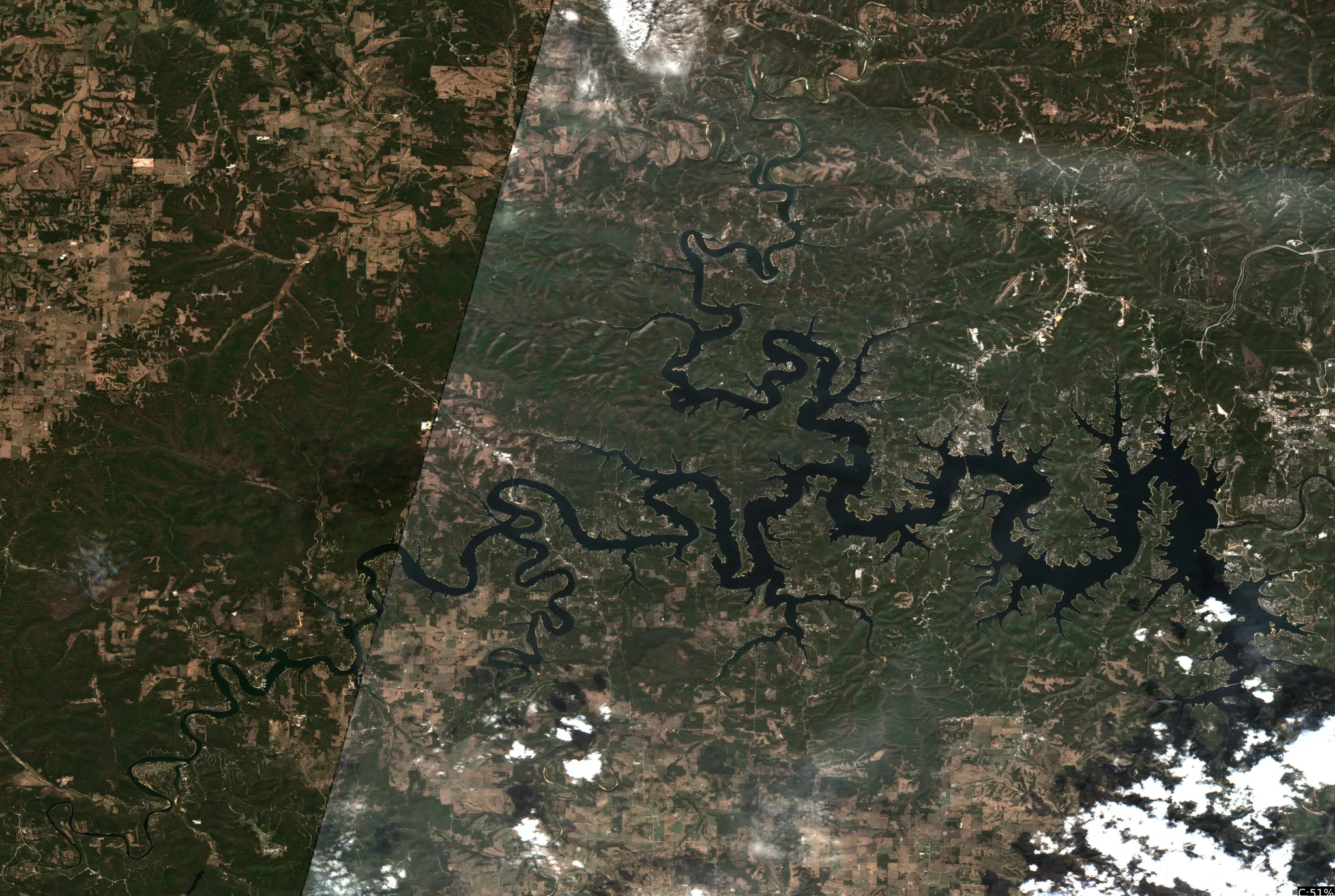
Image quality: usable — The imagery provides a clear, high-resolution view of the shoreline geometry, surface-color transitions, and man-made structures across a large geospatial extent. North-up orientation is verified by GIS metadata. sinuous shoreline pocket | northwest quadrant | Observed: highly sinuous shoreline geometry | Position: upper left | Scale: 1km to_5km | Evidence: shoreline geometry (95% visual confidence) main channel transition | center to east | Observed: wide surface water corridor | Position: center | Scale: 1km to_5km | Evidence: surface pattern (90% visual confidence) complex inlet system | southwest quadrant | Observed: narrow winding waterway | Position: lower left | Scale: 1km to_5km | Evidence: shoreline geometry (90% visual confidence) sinuous shoreline pocket | Derived: The high density of shoreline bends may provide varied habitat access. Because: the pixels show a highly sinuous shoreline geometry with numerous small inlets and points in the northwest quadrant Verify: Use a marine chart or GPS to locate specific points and inlets within these sinuous bends to check for submerged structure. main channel transition | Derived: The wider water area may represent a primary transit corridor. Because: the pixels show a significantly wider surface-water expanse compared to the narrow inlets Verify: Use depth sounder or bathymetric map to confirm the width and depth of the main body of water.
WeatherView details
Weather analysis for Table Rock Lake on 2026-11-04: moderate wind, stable pressure
Get water level historyView details
No written analysis was saved.
Every level point retains its source and date. A last-known gauge level is not a current access or ramp-clearance determination.
LakeMonster AI
Turn the lake into a fishing plan
Forecast read: Go sheltered · 10 AM. Use the imagery, weather, and listed species to choose your first area and when to move.
First area, exact setup, best window, and a backup.
Sign in or create a free account to use the quick questions. Building a plan and asking your own question are Pro.
Compare the next 3 days, scout imagery, and build a backup pattern.
8 sources for this lake
- Current water temp
- 79°F
- Water temp history
- 462 readings
- Hourly weather
- 224 hours
- Solunar timing
- 2/5
- Fish species
- 14 listed
- Satellite imagery
- 545 captures
- Thermal imagery
- 1487 captures
- Map structure
- available
Latest source update: Nov 22, 12:14 PM CST. Each image and reading has its own date.