NOAA Says Lake Erie's 2026 Harmful Algae Bloom Is Over
The 2026 cyanobacteria bloom in western Lake Erie has ended, NOAA reports, and the agency's end-of-season assessment rates it a moderate year—close to the outlook issued in June. Here is how the season unfolded from Maumee Bay to Port Clinton.
By LakeMonster News5 min read
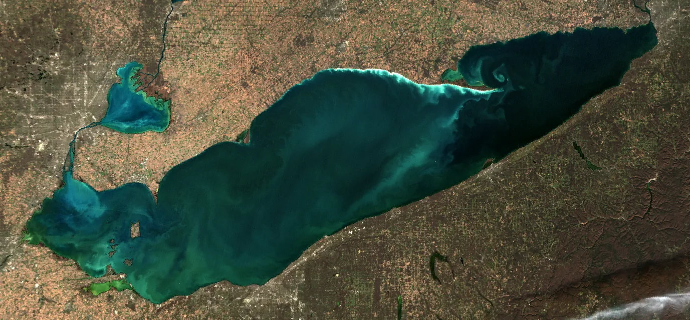
The 2026 harmful algal bloom in western Lake Erie is over.
That is the latest word from the National Oceanic and Atmospheric Administration, whose National Centers for Coastal Ocean Science (NCCOS) run the Lake Erie forecast. In a bulletin updated on November 21, 2026, forecasters wrote, "The 2026 cyanobacteria bloom has ended," and pointed readers to the official seasonal assessment. They said the forecast will return in May 2027.
Two days earlier, on November 19, NOAA issued that assessment. It gave the year a severity index of 3.4, which the agency classifies as a moderate bloom. That result landed almost exactly on the seasonal outlook issued on June 25, which had predicted a severity of 3.5, with a range of 3 to 4.5.
For people who boat, fish, or swim along the Ohio and Michigan shores, the message is simpler than the numbers: the summer's Microcystis bloom has run its course, according to the federal forecast. Local health departments still have the last word on any beach or drinking-water notice at a given ramp.
A slow start, a mid-September peak
NOAA's seasonal write-up traces a familiar western-basin pattern. The bloom began in Maumee Bay around July 12 and was slow to grow in both biomass and area, much as it was in 2025. It did not fully establish until early to mid-August, then reached its peak biomass and area in mid-September.
Intensity dropped quickly in mid-October, NOAA said, as winds picked up and clouds moved in. Low concentrations lingered into November. Through the season, the bloom stayed close to the U.S. shore, mainly from Stony Point, Michigan, to Port Clinton, Ohio, with the highest concentrations in and extending from Maumee Bay. Portions appeared off the Canadian coast near Leamington, Ontario, in early October and wrapped east and south of Pelee Island later in the month.
The seasonal severity index is not a single snapshot. NOAA calculates it from the three 10-day composite satellite images with the most cyanobacterial biomass. The June forecast, in turn, is an ensemble of statistical models that use Maumee River phosphorus loads into the western basin from March through July.
More intense than 2025, smaller than several recent years
On NOAA's scale, 2026 (3.4) was more intense than 2025 (2.4). The peak bloom area, however, was smaller than in 2025: 339 square miles, compared with 411 square miles in the relatively low-density bloom a year earlier.
Over the last decade, NOAA said, 2026 was most similar in overall severity to 2021, which also scored 3.4—but that earlier bloom covered a larger average area at its peak, 607 square miles. Maumee River cumulative total bioavailable phosphorus loads were similar in 2024 and 2026, yet 2024 was both larger and more severe, with a severity index of 4.2 and an average peak area of 626 square miles.
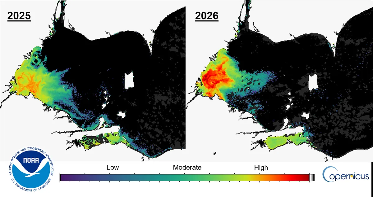 Photo: NOAA National Centers for Coastal Ocean Science, using Copernicus Sentinel data · Contains modified Copernicus Sentinel data 2025-2026; NOAA federal product
NOAA's comparison of the 10-day maximum bloom severity in 2025 (August 19–28) and 2026 (September 8–17). Credit: NOAA NCCOS, using Copernicus Sentinel data.
A longer view appears in NOAA's severity chart for 2000 through 2026. The 2026 bar sits in the moderate band (an index of 3 to 5), well below the very severe years of the 2010s, including the 2011 peak.
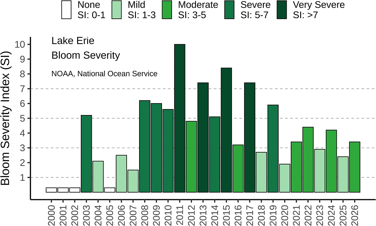 Photo: NOAA National Ocean Service · Public domain (U.S. government work)
Western Lake Erie bloom severity index, 2000–2026. Credit: NOAA National Ocean Service.
What the latest pictures show
The operational forecast's November 21 satellite product, built from the Ocean and Land Color Imager on the Copernicus Sentinel-3 satellites, is a true-color view of the lake after the bloom had shut down. Grey in those products marks clouds or missing data. NOAA's detection threshold on the mapped products is 20,000 cells per milliliter.
In mid-November updates, before the official end-of-season call, forecasters also reported that no toxins had been detected in western Lake Erie. A November 17 bulletin signed by Owens and Hounshell carried that line, and NOAA repeated it on the forecast webpage the next day.
That is reassuring, but it is not a blanket all-clear for every cove or every future week. Cyanobacteria blooms can be uneven, and state or local agencies may still post or lift site-specific advisories on their own schedules. NOAA's Lake Erie products are a western-basin forecast, not a substitute for a sign at a particular beach.
Looking ahead
Forecasters said they will be back in May 2027, when early-season projections typically resume, based on Maumee River discharge and phosphorus. Until then, the 2026 file is closed: a moderate year, close to what NOAA expected in June, peaking later and over a smaller area than some recent blooms, and, as of the late-season bulletins, without detected toxins in the western basin.
If you are headed to Lake Erie, check the current local advisory before you swim or let a dog near the water, and treat any leftover scum or discolored water with caution even after the seasonal bloom is declared over.
Frequently asked questions
Is it safe to swim in western Lake Erie now? NOAA says the 2026 western-basin cyanobacteria bloom has ended, and mid-November forecast bulletins reported no toxins detected. That is not the same as a permit to ignore local beach notices. Follow any advisory from Ohio, Michigan, or local health officials at the place you plan to enter the water.
What does a severity index of 3.4 mean? NOAA calls 3.4 a moderate bloom. The index is based on satellite estimates of cyanobacterial biomass during the three worst 10-day stretches of the season, not on a single day's photograph.
Did the June forecast get it right? Closely. On June 25, NOAA predicted a severity of 3.5, with a range of 3 to 4.5. The final score was 3.4.
Where was the bloom worst? NOAA said the highest concentrations were in and extending from Maumee Bay, with the bloom hugging the U.S. coast from Stony Point, Michigan, to Port Clinton, Ohio, and later appearing near Leamington and Pelee Island, Ontario.
Questions and answers
- Is it safe to swim in western Lake Erie now?
- NOAA says the 2026 western-basin cyanobacteria bloom has ended, and mid-November forecast bulletins reported no toxins detected. That is not the same as a permit to ignore local beach notices. Follow any advisory from Ohio, Michigan, or local health officials at the place you plan to enter the water.
- What does a severity index of 3.4 mean?
- NOAA calls 3.4 a moderate bloom. The index is based on satellite estimates of cyanobacterial biomass during the three worst 10-day stretches of the season, not on a single day's photograph.
- Did the June forecast get it right?
- Closely. On June 25, NOAA predicted a severity of 3.5, with a range of 3 to 4.5. The final score was 3.4.
- Where was the bloom worst?
- NOAA said the highest concentrations were in and extending from Maumee Bay, with the bloom hugging the U.S. coast from Stony Point, Michigan, to Port Clinton, Ohio, and later appearing near Leamington and Pelee Island, Ontario.
Lakes in this story
Sources
- Lake Erie Harmful Algal Bloom Forecast, NOAA National Centers for Coastal Ocean Science (read Nov 22, 2026)
- Lake Erie Harmful Algal Bloom Forecast bulletin (2026-11-21), NOAA National Centers for Coastal Ocean Science (read Nov 22, 2026)
- Western Lake Erie HAB Seasonal Assessment (2026-11-19), NOAA National Centers for Coastal Ocean Science (read Nov 22, 2026)
Photo credits
- NOAA National Centers for Coastal Ocean Science, using Copernicus Sentinel-3 OLCI data · Contains modified Copernicus Sentinel data 2026; NOAA federal product · source
- NOAA National Centers for Coastal Ocean Science, using Copernicus Sentinel data · Contains modified Copernicus Sentinel data 2025-2026; NOAA federal product · source
- NOAA National Ocean Service · Public domain (U.S. government work) · source