Storms Lift Navajo Reservoir Nearly 60 Feet, and Lake Powell Rises Too
Back-to-back autumn storms flooded parts of the Four Corners and sent a surge of water into Navajo Reservoir, which NASA says rose nearly 60 feet in about seven weeks. Farther down the Colorado River system, Lake Powell also climbed more than 20 feet—welcome storage, but still a reservoir that is only about 28 percent full.
By LakeMonster News5 min read
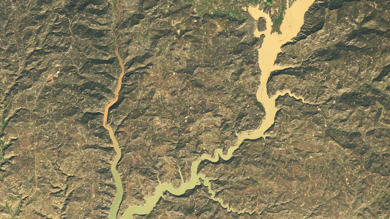
Navajo Reservoir, which straddles northern New Mexico and southern Colorado, rose nearly 60 feet in a matter of weeks after heavy autumn rains swept the Four Corners.
That is the picture drawn by NASA Earth Observatory, which compared Landsat 9 images from September 20 and November 7, 2026, and by water-level data from the U.S. Army Corps of Engineers. The November 7 scene shows a wider, sediment-stained lake. On that date, NASA reported, the reservoir stood at its highest level since August 2019 and at 108 percent of the average capacity for the date. On September 20 it had held just 60 percent of average.
The jump is striking because the lake had a weak start to the year. NASA noted that a snow drought across the West in the winter of 2025–26 left relatively little spring snowmelt, which is usually when Navajo Reservoir rises. The Bureau of Reclamation also decreased releases from Navajo Dam on September 16 and 17, just before the storms arrived.
Flooding on the way in, relief in the reservoir
The same weather that refilled the lake caused serious flooding. NASA, citing official gauges and news reports, said back-to-back extreme rain events in late October and early November pushed some rivers to record or near-record levels.
Pagosa Springs, Colorado, about 40 miles northeast of the reservoir on the San Juan River, was especially hard hit. In the first round of rain, 5.05 inches fell in town, and on October 23 the river reached major flood stage. After more rain, the river spiked again on November 1, nearly to the record set in 1911. Officials issued evacuation orders, and responders rescued dozens of people, NASA reported, while water damaged streets and property.
Precipitation from early September through early November was two to four times average across the Four Corners, NASA said, in a region already dealing with long-term drought, a poor snowpack, and high temperatures in 2026.
Those downpours were dangerous along the rivers. They also helped on the drought maps. NASA pointed to the U.S. Drought Monitor's November 3 summary, which found that "short-term drought has ended for the Southwest and Great Basin," even though long-term drought persists in places.
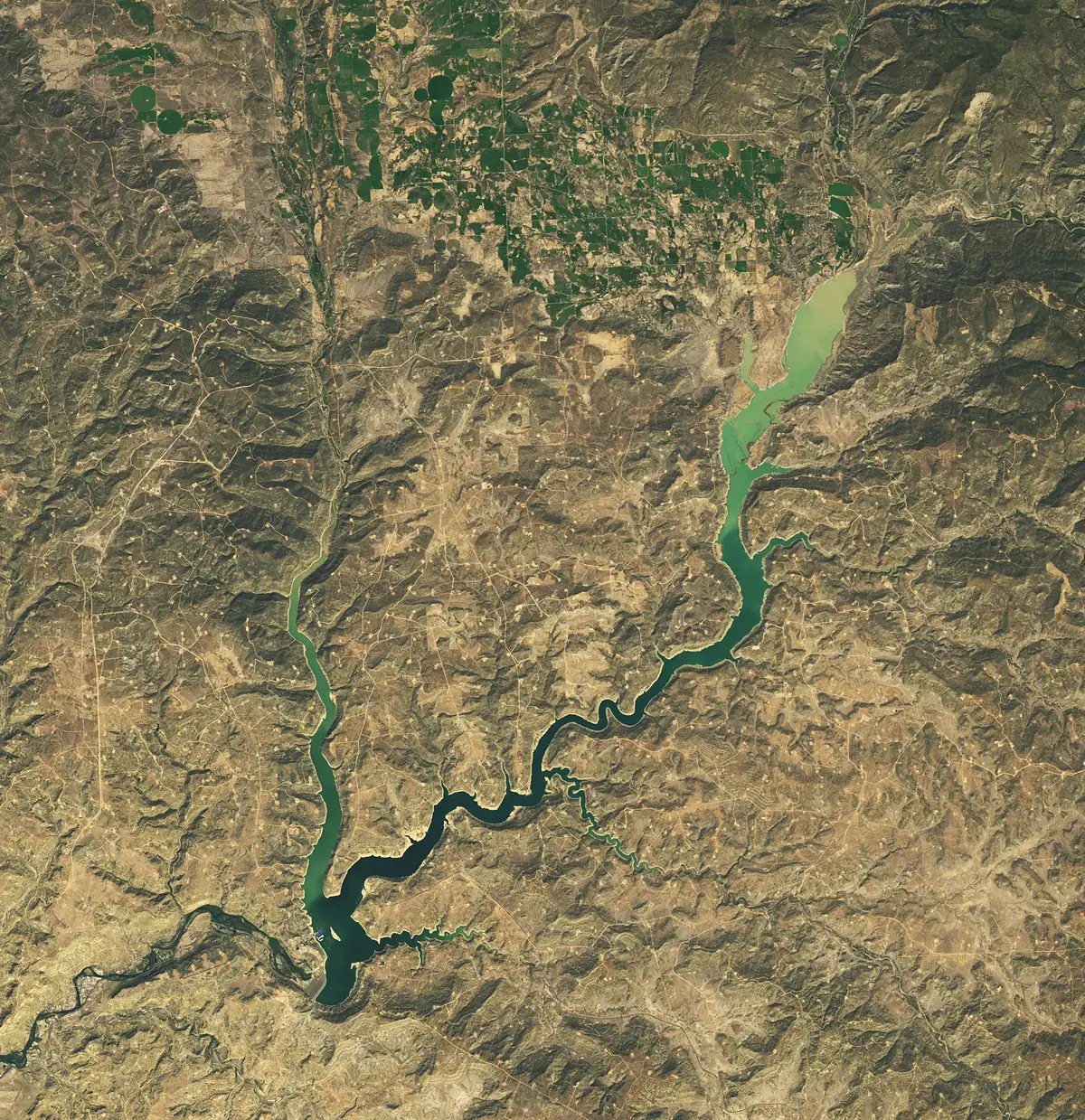 Photo: NASA Earth Observatory image by Michala Garrison, using Landsat data from the U.S. Geological Survey · Public domain (U.S. government work)
Navajo Reservoir on September 20, 2026, before the autumn storms. NASA Earth Observatory image by Michala Garrison, using Landsat data from the U.S. Geological Survey.
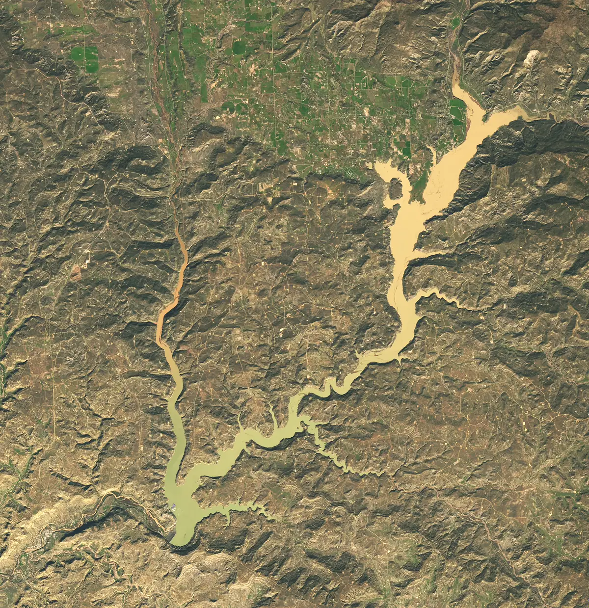 Photo: NASA Earth Observatory image by Michala Garrison, using Landsat data from the U.S. Geological Survey · Public domain (U.S. government work)
The same view on November 7, 2026, after the reservoir rose nearly 60 feet, according to U.S. Army Corps of Engineers data cited by NASA. Image by Michala Garrison, Landsat / USGS.
Lake Powell also climbed—but is still far from full
The surge was not limited to Navajo. Provisional daily figures from the Bureau of Reclamation show Lake Powell, the country's second-largest reservoir, rising quickly through the same period.
On October 15, Reclamation recorded Powell at 3,519.79 feet above sea level, with 5,249,812 acre-feet in storage. By November 19, the lake stood at 3,540.62 feet and 6,488,104 acre-feet. That is a gain of about 20.8 feet and roughly 1.24 million acre-feet in a little more than a month. Reclamation marks those daily numbers as provisional and subject to review.
A fuller snapshot of the Colorado River system comes from Reclamation's weekly hydrologic update as of November 15. It listed Lake Powell at 3,539.99 feet, up 1.15 feet on the week, with 6,448,000 acre-feet in storage—28 percent full. Lake Mead was at 1,041.14 feet, up 1.48 feet on the week, and 27 percent full (7,056,000 acre-feet). The system as a whole held 20,119,000 acre-feet, or 34 percent of capacity, compared with 21,848,000 acre-feet, or 37 percent, a year earlier.
In other words, the storms delivered a real bump, especially at Navajo Reservoir, without filling the big Colorado River reservoirs. Powell and Mead remain well below what most boaters would think of as a full lake.
Reclamation's weekly report also showed a wet start to water year 2027 in parts of the basin, and it raised the forecast for unregulated inflow to Lake Powell. Those outlooks can change quickly this early in the season, the agency cautioned.
A wet El Niño pattern, with limits
NASA noted that wet weather in the Southwest is often associated with El Niño, when the jet stream near the equatorial Pacific tends to strengthen. Experts cited in the Earth Observatory story said the low-pressure system that delivered the autumn 2026 rain sat at a low latitude for the time of year and drew energy from unusually high ocean temperatures, and that the El Niño pattern then underway can make it more likely for moisture-laden storms to reach the Southwest interior.
None of that erases the flooding along the San Juan, or the fact that long-term drought has not disappeared. It does explain why a lake that started the year short on snowmelt could rise nearly 60 feet before Thanksgiving, and why Lake Powell could add more than 20 feet without climbing out of the bottom quarter of its capacity.
If you are planning a trip, check current water levels, ramp conditions, and any flood or recreation notices at the reservoir you intend to visit. A rising lake is good news for storage. It does not always mean every launch is open, or that every side canyon is back to a familiar shoreline.
Frequently asked questions
How much did Navajo Reservoir rise? NASA, citing U.S. Army Corps of Engineers data, said the reservoir rose nearly 60 feet (18 meters) between the September 20 and November 7 Landsat 9 images. On November 7 it was at 108 percent of average capacity for the date, and its highest level since August 2019.
How much did Lake Powell rise? Reclamation's provisional daily data show Powell at 3,519.79 feet on October 15 and 3,540.62 feet on November 19, a rise of about 20.8 feet. As of November 15, Reclamation's weekly update listed the lake at 28 percent of capacity.
Did the storms end the drought? The U.S. Drought Monitor, as quoted by NASA from a November 3 summary, said short-term drought had ended for the Southwest and Great Basin, while long-term drought persists in places.
Why is the November water such a different color? The November 7 Landsat image shows tan, sediment-laden water in the newly flooded arms of the reservoir, a common sight after heavy runoff. NASA used the two satellite scenes to show the change in shoreline, not to measure water quality.
- Navajo Reservoir
- Lake Powell
- Lake Mead
- Drought
- Colorado River
- Nasa
- Bureau Of Reclamation
- Water Supply
- New Mexico
- Colorado
- Utah
- Arizona
Questions and answers
- How much did Navajo Reservoir rise?
- NASA, citing U.S. Army Corps of Engineers data, said the reservoir rose nearly 60 feet (18 meters) between the September 20 and November 7 Landsat 9 images. On November 7 it was at 108 percent of average capacity for the date, and its highest level since August 2019.
- How much did Lake Powell rise?
- Reclamation's provisional daily data show Powell at 3,519.79 feet on October 15 and 3,540.62 feet on November 19, a rise of about 20.8 feet. As of November 15, Reclamation's weekly update listed the lake at 28 percent of capacity.
- Did the storms end the drought?
- The U.S. Drought Monitor, as quoted by NASA from a November 3 summary, said short-term drought had ended for the Southwest and Great Basin, while long-term drought persists in places.
- Why is the November water such a different color?
- The November 7 Landsat image shows tan, sediment-laden water in the newly flooded arms of the reservoir, a common sight after heavy runoff. NASA used the two satellite scenes to show the change in shoreline, not to measure water quality.
Lakes in this story
Sources
- Water Surges Into Navajo Reservoir, NASA Earth Observatory (read Nov 22, 2026)
- Upper Colorado Region 40-Day Data: Lake Powell, U.S. Bureau of Reclamation (read Nov 22, 2026)
- Lower Colorado Weekly Hydrologic Update (November 16, 2026), U.S. Bureau of Reclamation (read Nov 22, 2026)
- Navajo Reservoir, U.S. Army Corps of Engineers (read Nov 22, 2026)
Photo credits
- NASA Earth Observatory image by Michala Garrison, using Landsat data from the U.S. Geological Survey · Public domain (U.S. government work) · source
- NASA Earth Observatory image by Michala Garrison, using Landsat data from the U.S. Geological Survey · Public domain (U.S. government work) · source
- NASA Earth Observatory image by Michala Garrison, using Landsat data from the U.S. Geological Survey · Public domain (U.S. government work) · source